HAL Id: hal-02014702
https://hal.parisnanterre.fr//hal-02014702
Submitted on 11 Feb 2019HAL is a multi-disciplinary open access archive for the deposit and dissemination of sci-entific research documents, whether they are pub-lished or not. The documents may come from teaching and research institutions in France or abroad, or from public or private research centers.
L’archive ouverte pluridisciplinaire HAL, est destinée au dépôt et à la diffusion de documents scientifiques de niveau recherche, publiés ou non, émanant des établissements d’enseignement et de recherche français ou étrangers, des laboratoires publics ou privés.
Investigations at Ramat Saharonim: A Desert Neolithic
Sacred Precinct in the Central Negev
Steven Rosen, Fanny Bocquentin, Yoav Avni, Naomi Porat
To cite this version:
Steven Rosen, Fanny Bocquentin, Yoav Avni, Naomi Porat. Investigations at Ramat Saharonim: A Desert Neolithic Sacred Precinct in the Central Negev. Bulletin of the American Schools of Oriental Research, American Schools of Oriental Research, In press, pp.1-27. �hal-02014702�
Investigation
s
at Ramat Saharonirn:
A De
s
ert Neolithic Sacred
Precinct
i
n th
e
Central
Negev
STEVEN A. ROSEN Archaeological Division Ben-Gurion University of the Negev
POB 653 Beersheva. lsrael
rosen@bgu.ac.il
YOAV AVNI Geological Survey of Israel
30 Malkhei Israel Street Jerusalem 95501. lsrael
yavni@gsi.gov.il
FANNY BOCQUENTIN Centre Nationale Recherche Français
MAE Université Paris-X Paris, France
fanny.bocquentin@libertysurf.fr
NAOMl PORAT
GeologicaJ Survey of Israel 30 Malkhei Israel Street Jerusalem 95501, lsrael naom i.porat@gsi.gov. i 1
fnve.stigations aJ t/le open-air sltrf11e ami cairn complex at Ramat Saharonim in the Makhtesh Ramon in 1/te central Negev reveal a sai:red precinc/ or ritua/ ce111er with a focus on a morcuary cult, artributable to .tlie Late Neolirliir, ra. 5000 n.c. The four shrines are aligned wirh the set1in1: Still of the s11111mer solstice. along with other l and-scape features. The tilree /1111111/i l!Xrm•ared, mughly rontemporary with the shrines. re-vea/ed primary and secondary /Juriai.f and inlentimia/ bnne realig11111ent. Excavations al Shrine 4 allow derailed recon'i/rttf'lirm . of siteformatio11 pmces.ves, demonstrating fo11g-1erm development of the fen111res of the complex. ln general, the megalithic aspect of the site, 1he symbolic nspear 1~{ tlw alig11111en1.1·, and the a11riburio11 11• the Lme Neolithic
suggest a close rela1io11s/Jip berween 1he rise of the de.sert cuit and tribal sociery
asso-ciated witlz the earlieJI intmductin11 of domestic herd animais i11to the central Negev.
A
LNTRODUCTLON
s with the transition from hu111ing-galbering to farming in the Mediterranean zone. the rise of pastoral nomadism in the desert per -iphery entailed far-reacbing transform<Uions in the basic cultural matrix of the desert. The shift from hunting animais to herding them marked a fundamen -tal transformation to a society based on ownershîp of the basic rneans of subsistence, and the consequent need to preserve those meam. and entailed profound concomitant change in virtually every realm of society (e.g., lngold L980). Archaeologically, it should corne as no surprise that the earliest evidence for elaborate shrines reflecting public ritual and rnortuary cuit in the southern Levantine deserts, in the Late Neoli1hic
ca. 5500-5000 B.c.. only slightly postdates the ear-liest i11fiJtration and adoption of berd animals-sheep and goat- replacing hunting as a primary subsistence base.
The presence of ancient cuit and mortuary sites in the deserts of the southern Levant ba~ been known since the late 19th century-for example, t:rom Palmer"s ( 1872: 121) discovery of the nawamis fields of easl Sinai. These sites exhibit a wide range of types and functions, frorn single stelae, groups of stelae, and elaborate arrangements of standing stones, to tumuli and fields of lumuli and otber mortuary structures, and on lhrough various types of other constructions, usuaJly lumpeù into the general rubric of "open-air shrinc'' (see especially Avner 1984; 1990; 2002; also Yisrael and Nachlieli L998). Other
difficult-to-classify features. such as Lhe "K-Line" (e.g., Haiman 2000) may also be included in Lhe general category. The general class of calL s truc-tures ranges in date from the sixtb mHlennium a.c. through recent limes-a~. for example, in open-air mosques- and thus has been assocint:ed with the com -plete complement of cultures lmown in Lhe deser1 from the historical and pmtohistorical periods.
ln cerms of the earlier part of this long Lime pan, several recenc investigations provide imporiant back -ground for the excavations at Ramat Saharonim. The earliest of these is the systematic exploration of the nawamis fields al Ein el Hudera (Bar-Yosef et al.
J 977) and Geb.el Gunna (Bar-Yosef et al. 1986) in Sinai. These studies documented the nawamis. cy -lindrical corbel arched buildings usually 4-8 m in extemal diameter and 2 m high, as mortuary s truc-tures dating to roughly the early fourth millennium B.c. They reflect a local pastoral society (e.g., Coren 1980) organized at a tribal level. wilh cultural linki. 10 Egypt. La1er analyses (Bar-Yosef et al. 1983; Hersh-kowitz et al. 1985) also established a seasonal and cosmological aspect to the nnwarnis; doorways are aligned to the west, facing the sening sun. with de-viations apparently in accordance with the season of construction but wiLh modaliUes suggesüog seasonal preferences. The focus on the setling sun clearly has symbolic meaning and is tied Lo Egyptiao beliefs in lhe connections be1ween dealh, lhe west. and the set -ting sun.
The tumulus fields of the central Negev are con-ceptualJy similar to the nawamis in terms of spatial clustering of the structures and 1heir morruary asso -ciations. However, unlike 1·he nawamis, tumuli ex -cavations have usually (but not aJways) shown Lhem to be empty of burial remains, either from poor prcs -ervation or perhaps the removal of 1hc bones (c.g., Haiman 1992). Also contrasting wilh the nawnmis, buriaJ goods are rare in the tu mu li, rendering chrono-cultural anribution problematic. Although rcciang u-lar tumuli have usually been auribULed ro the ln1er -mediate Bronze Age (= EB lV
=
MB l), Haiman ( 1992: l993) bas suggested that the standard round tumuJi be dated to Lhe Early Bronze Age, based on a pauern of geographic association with large Early Bronze Age campsites. Avner (2002: 154-55) has presented radiocarbon date indicaling earlier oc-currences. and, anticipaling later discussion. the Ra -mat Saharonim excavations indicaie a deeper his1ory with the tradilion of tumulus burial beginning in 1he Late Neolithic.Open-air shrinei., sometimes referred to as tem-ples, have also been investigated. Yogev (1983) ex-cavaced a courlyard shrine with stelae in a cist in the focal corner of the shrine. in the Uvda Valley. llated to the sixlh millennium cal s.c. Eddy and We n-dorf ( J 998; 1999: 36, 39) documented a rectangular shrine in eastern Sinaï similar to those al Ramat Saharonim. also dating it by radiocarbon to the sixth milleon.ium caJ
o.c
.,
and Rothenberg (1979: 125. lig. 28) excavated anothcr, uggesting it be dated 10 the Pre-Ponery Neolithic on the basis of associated anifacts. Given the absence of artifacts ar vinoally ail other such sites, and 1heir consistent Late Neo-lithic attributîon, il is likcly ù1at the shrine at Ein Yarka was builL on an earlier occupation. More si g-nificantly, Avner's (e.g., 1984: 1990: 2002; Avner and Cam1i 2001) pioneering long-tenn research pro-gram on tbe desen cuit has documented numeroushrines in the Negev and Sinaï, many typologjcally idemical 10 those of Ramat Saharooirn. He. too. has dated the origins of these structures to the Late Nenlithic and has noced solstice alignments which he has interpreted in a cosmological framework drawn from lmer Mesopotamian civilization (Avner 2002: 102-J). On chis basis. he suggests a winter sunrise as opposed to a summer sunsel orientation.
Wilh respect to Ramat Saharonim itself, Cohen cxplored the site in the 1970s. publishiog plans and n few surface artifacts in his doctoral thesis ( 1986: 8-9. pis. 5-6; also see Avner 2002: table 14.9-12) and Inter in hil> synthetic study of che Negev High-land ( 1999: 21-24). Tnformal test excavations werc also cbnducted but never publisbed. Chronologi-cally. Cohen attributed the site to the Chalcolithic perioù based on su.rfacc ar1ifac1s, including several wbular scrapers !Cohen 1999: fig. 9: 1. 2, 7) and a simple bifacially retouchcd knife (Cohen 1999: fig. 9: 11 ). ln fact. tabular scrapers as a class appear in 1he late stages of ù1e Pottery Neolithic (second half of Lhe sixtb millennium B.C.) (Ro en L997: 75) and continue through the Early Bronze Age. The bifacial knifo is 1101 diagnostic. lniûal assessments based on survey work also tended 1oward the Early Bronze Age attribution (Rosen and Rosen 2003). especially based on the strong architectural simiJarities be -lween the Early Bronze Age tumuli in the Negev Highlands (Haiman 1992: 1993) and those of Ramat Sahnronim.
The investigations at Ramai Sabaronim were ini -1ia1ed in order to build on these pioneering works. The general goal of 1he project was to survey the
site (Rosen and Rosen 2003) and excavate part of il in a methodologicaJly dgorous fashion in anticipa-tion that the greater detail would provide answers lo some of the quesùons conceming the early desert cuit not yet rcsolved. Three sets of issues were LO be addressed:
1. The explication of the relationships. chr ono-logical and cultural, between the different com
-ponents of the site. using a suite of field and laboratory methods. including assay in both
radiocarbon and opticaJly stimulated l umines-cence (OSL) datiJ1g.
2. The documentation of ù1e slratigraphy of o shrine in order to understand its construction, ils original fon11. the different phases of
develop-menl, and the post-abandonment formation pro-cesses that result in the current ite features. 3. Examinaiion of the relaùonship between the
site, the landscape. and Olher natural features. including astronomical aspects (cf. TilJey 1994;
Cannichael et al. 1.994).
The first phase of the project. initiated in 1999, consisted of the intensive mapping of the site (Rosen
and Rosen 2003). A large-scale map of the entire precinct was prepared, and 1:20 stonc-by-stone plans of each shrine were completed. The solstice orient<-t· lion of the shrines was also documented.
THE REGJON AND THE
SITE AREA
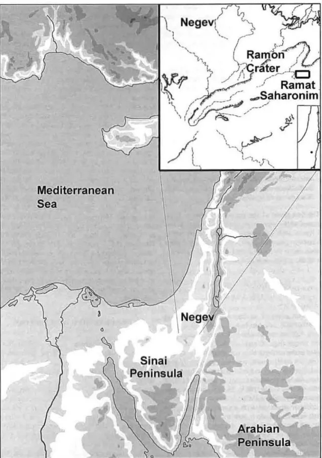
The cuit complex at Ramat Saharonim (Israel
Grid 1434/0035) is located south of Mt. Ardon in the
eastem half of 1he Makhtesh Ramon. a large ero-sionaJ cirque (e.g .. Y. Avni 1993: Zilbem1an 2000) located in the soulhem Negev Highlands (fig. 1 ). The region is a rocky desert, receiving roughly 75 mm of rainfall per year, and is characlerized by sparse Saharo-Arabian vegetatfon (e.g .. Roseni\11 and Gllead l 985a: l 985b; Danin 1983: 35. 53). Surface sedi
-ment are reg soils. and the shrines resl on a devel -oped desert pavement with a sandy substrale. The tumuli rest on limestoae bedrock. Geomorpbologi-cally, the site is located in a shnllow valley fonned
between sets of paraUel cuesta clitfa varying in heigbt from roughly 2 m in the west to up Lo 5 m in
tbe east (fig. 2). GeologicaJJy, the site lies on the tran -sition from the Lower-Middle Jurassic Ardon
For-m,ation (Zak 1968) (prirnarily, Limestone wiù1 clays, maris. and some sandstones) to the Middle Jl!rassic
lnmar Formation (sandstone) (fig. 3).
Historically, the area has been primarily the reaJm of pastoral nomadic societies. The Azazmeh and
Saidiyyin Bedouin tribes inbabited the region in the
l 9lh and early 20th centuries. During the periods of clnssical antiquity, the Early 1slamic and Byzantine, Roman, and Hellenis1ic periods. pastoral sites of vari-ous kinds dominate the arcbaeology of the Makhtesh Ramon. including most notably Nabataean campsiles (e.g .. Rosen 1993). lndeed. the site lies adjacent to the Nabataean spice route leading from Perra Lo Gaza (e.g .. Cohen 1982). Although intensive run-off irri -gation farming was practiced in desert areas some -whal farther north, in ùie lrano-Turaninn zone, ùiis
re.gion remained unexploited agriculturally. With
re pect to site prior LO the classical era. survey in the general region has revealed campsi1es primariJy from lhe Early Bronze nnd lntermediate Bronze Ages, although not in the immediate vicinity of the site.
Neolithic sites are known from the northern Arava (e.g .• Taute 1994). farther south, in the Uvda Valley (e.g .. Goring-Morris and Gopber 1983; Avner 1990). and in lùgher area.-; to the west and north (e.g .. Noy u111d Cohen 1974; Rosen 2002: Goring-Morris 1993: Si mmons 1981 ). Across the Rift Valley. the bi
gh-lands of southèrn Jordan saw the evolution of village and Ltrbao settlements from the Nêolithic thrnugh the Bronze Age in a less arid cnvironment more suilable
lo scdentary and agricultural pursuits. No habitation sites are found in the immediate vicinity of Ramat Saharonim.
GENERAL Sfl'E DESCRlPTLON
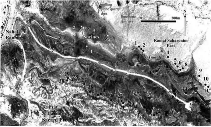
The Ramat Saharonim sacred precinct (fig. 2) con ists of three areas: ( l) the Sbrine Area. wilh four shrines and associated instaUations: (2) Ramat Sa -haronim East, consisting of L4 tumuli on 1wo parallel
cuesta cliffs east of ù1e Shrine Area: and (3) cbe
Southern Ridge, with 16 tumuli aligned on the cuesta cfüf south of the Shrine Area and Ramat Saharonim East. ln addition 10 the cuit complex. a sundstone quarry for the production of milling stones is locaced approximately 100-200 m nortb of the Shrine Area. probably dating 10 the Early Bronze Age (Abadi 2003; Abadi and Rosen in press).
The Shrine Area consisL~ of four courtyard shrines (numbered Shlines 1-4; fig. 4). A detailed descrip1ion
Mediterranean
Sea
•
Fig. 1. Location map showing the Mskhtesh Ramon and the Negev ln the Levant, and the location of Ramat Sa -haronim with1n the Makhtesh Ramon.
11
,
..
,\
..
• : 1
'•
~ ~
t"
~
Fig. 2. Aenal photograph of Ramat Saharonim wlth srte leatures tndlcated
c
\
c
1"
B 12"
c
.
,,,,.
.
....
.
..
,~ ... .;..
1
1
~
~~
~c
...
..
, ~ ;, çl';; • !r.
... f
·~.
·;~ .l; ~ ~c
'.
....
B ,):·~~,,'\ D D D....
... Il Shnnr 4 11 ~ 11 10• BA Upper conglamcrate
Ramat
B Lower conglomelllteSarahonim:
wcll prclCIYl:<Ic
Lower conglommne crodedShrine
D Surface covtn:d by local
rock fragments
Geomorphology
p Playa
12 No. of 11nlignpbic unit
B '<. Dip direction and ioctinal.ioo
7-10'
Fig. S. Norlhwest v1ew of unexcavaled Shrine 3 loward Lower Cre1aceous volcanlc Ml. Ga'ash and the northern wall of lhe Makhtesh Ramon Nole the orientation between fow hills on e1ther sfde of lhe shnne.
of the individual shrinc!.1 as bai-.cd on 'urvey has been presented in the repon on 1hc 'itc survcy (Rosen and Roscn 2003; nlso sec Cohen 1999: 21-24; Avner 2002: table 14: 10-12). but se verni fc111urcs derived from the '!urvcy arc imporcant for undcri.tanding the nature of the complex, a wcll a' it., chronology and development. First. each shnne i.how' two compo-nentl.. a largcr. primary rectangular 'tructure. and a
maller. more squarii.h '>Ccondttr) one. located on the nonh side or the primary. Although Shrine 3 laèb thii. structure, it 'hows rcmains of u dilTerent chara c-ter. vaguely rcminisccnt of the .,ecundary ~trucLUres associ:ued with the other shrines. but con'ltructed in a difTcrent fa.,hion and IC\'\ well prescrvcd. Avoer {2002: 120-22. 126) ha~ refcrred lO lhese pairs or i.tructure a temple pairi. or 1w1n temple<.. 1mplying 1heir con1emporaneity and llUggc.,ting thcy con~ùtute male and femalc pairs, perhap <;pecihc godl> and go<ldel> 'C!.. ln thil> light, the importance of establish -ing 1hc chronological relationship j., clcar.
The priniary structures are cach on the order of 20-22 m in leng1h. They cons1s1 of a IHrge forward wnll on the wcs1 side of the rcctungle. built or two rows of large limestone blocks or slabs with a space of 20-40 cm be1ween the rows. and in the east. a courtyard, fcnced off by a single row. '>ingle course, or small Monc slab . This fencc i' now fallen but origmally stood upright, a<; rcnected 111 a few slabs -;till embeddcd in the ground in Shnne 1 The source for 1he limcstone bloclo..s (sec di\CUS'>ton below) is locaJ. The we 1ern wall. ongm:illy slood to a height of about 1.5 m. ba ed on the pre,crvcd height of the walls and the quantity of ... 1one fall on 1hc surface and found in excavation.
1Thc teml .. 1hnnc .. 1~ emplo}cd hcrc 111 ordc:r11111,01d wme of the p1tlolls of u~mg londcd 1enn• -uch J\ .. temple .. or .. ,illlclll.ir)." wh1c:h rc,onuu.: "uh 01hcr mcan111g,. \UO:h '" hou\c
or
god. or pro-'1dmg shcher, etc Other opt1m1'. \UCh "' "euh ~tructun::· pc:rhap~tcchmcnll} more corrcc1. 'eem awk" urd
The sccondury stn1cturcs, buih on the north side of 1he primtu·y shrines. ure square or ni.!ar square structures, upprnximately
8
mon a sic.li.!. built of what appearJ. to have been a single row and single courset1f roumkd wudi cobbles placcd carefully one against the othcr n1ey each also show an intcrn:ù feature: a mali '-lone pile. poorly pre.\crved and d10icuh to de-scnbe. TI1c \Ource for the i.tone of 1hc econdary i.tructurc' appcar. to be conglomerate e~pol>ures lo-cated in the immediatc vicinity of the 5hrinc (fig. 5). The con1ra ... 1 with the primary s1ructurci. is triking. As abovc, Shnne 3 doei. not show a ·imilar second-ary 'itructure. although smalt "fonce" slabi. suggc t 1ha1 some other feature remim cent ol the 'ecoodary ... 1ruc1urcs walt prei.ent (contra Cohen 1999: fig. 23: Avner 2002: fig. 5:2).
ln add111on to the 'econdary '>lructure ... nonde -'>Cnpl slone 'cutter in roughly linear pattern!>. appar-enlly panially lhe re ults of human fü:tivitie~. and a few iimall coni.1ruc1ed features ~uch a!. boxe!. made of small limcl>tonc slabs. arc locatcd uround 30 m wesl of Shrinci. 1. 2. and 4 and coincidl.' wi1h con-glomcratl.! cxposures. Avner {2002: 1 16- 17, fig. 5:2) refen. to thc!tc remuins as "circlc chains," but it is dif
-ficult to 'lce any patterns.
The 30 large tumuli at Ramat Saharonim East and the Southern Ridge are arranged in 1wo rough lines along the parallel cuc!.ta cliffo;. '!Omewhat con verg-ing toward the ca ... 1. The tumuli arc cach 4-8 macro s m the ba\I.' and about 1-2 m high. con.,tructed of limestonc bluet....:;. ln many cases. a margin of larger '>IOnes i' cv1dent around the ba.,ul circumference. wilh the remaining -.1one~ of the cairn piled more haphazardly on top. MoM of the tumuli are concave on top. and excavations at 01hcr 'itci. (e.g .. Haiman 1992: 1993). U'> well ~Ls at Ramat Saharonim. indicate the prc. encc of bunal ci t. in .. ide. often lacking skel-etons. al tht: b~e of 1hc tumulu~. A . ingle cairn <Tumulus 30> opcned in the 1980s by urcbaeologi·1s working for the l rael Department of Antiquitie~
revcaled a keleton (Y. Israel. persona! communi
ca-1 ion. 2000).
The specific locations of lhe featurei. in lhe com
-plex were clearly chosen for Lheir position!> amid the
smaJI- cale topographie relief and larger-scale lnnd
-cape features. Alignmems of the shrines were derer
-mined by landscape feamres- mos1 nouibly a large.
black volcanic mouniain in the distance (fig. 5)-ancl to accord generally with the seuing sun of the 1>um -mcr olsticc. with nzimuth deviations from only 2°
to 8° (Roscn and Roscn 2003). Thrce of the four
shrines were placed so as 10 view this sol1>1ice i.uni.c!I
in Lhe shallow depre sion between two low hi lb (fig. 5). The oricntution lOward spccific geogrnphic fca
-ture. in the nonhwes1 <:trongly suppons the summt!r
sols1icc sunset interprclation of 1he alignmc111, ai.
oppose(.) 10 the wintcr sunrise suggcsced by Avncr
(2002: 102-3). for whicb no geographic pmterns arc
evident. Although il is diflicuh 10 pcrceivc any clèar
pattern with respect LO the placement of 1he wmuli
vis à vi the shrines, the cliffs constitute folsc hori
-zons. wilh Lhe tumuli visible in silhouetLc from grcm
dis1ances. seeming to integrate visually wnh more distant ridges.2 The shrines are locaied tll the open
(ea~t) end, between the two lines of 1umuli. They nre.
on one hand, set off from the tumuli, and on 1he
other. merge with them, forming :l large- cale cum -ple.>.. There can be littlc doubt as to the deliberate choice in thesc alignments and Lhc placement ot lhe
StlC features.
THE GEOLOGY ANO
GEOMORl'HOLOGY OF THE SITE The special nature of the cuit complex ai R<1mm
Saharonim suggested 1ha1 <letailed cxplica1îon of
it:-geological and geomorphological con1ex1s might o(. fer important insigh1s into understanding various is
-sue:, of site location. feature placement, con:.truction. and general site fornrntion. To this end, the following investigation wcre undertaken:
J. A detniled geologicaJ scc1ion of the site arèa
wai. con!>truCtcd (fig. 3). providing a kcy for un -derstanding û1e nature of 1hc site sediments, 1hcir di tribu1ion, and 1hcir ultimaie origin!..
2. Dctailed geological and geomorphologicnl
maps of both the general site area and 1hc
:yu, al Yd.uueli suggc~tcd 1he pos~ibihlu~' of a rcln11on\h1p bc1w~n the di\1ant ndgcs and th.: tumuli on th.: ncarby .:l1fl\.
Shrine Aren were constructed (figs. 4 and 6). nllowing beuer comprehensioa of 1he detail.
of 1he placement of individual archaeological feaiure in the l311dscape.
3. Geoarchaeological survey (on which lhe ectioa and maps were based) also locatcd special
gco-logical features, sucb as the limestone quarries/ cxposures from which lhe building material. for the primary shrines and mmuli were taken. Thi
survey also documented the location of the con -glomcrate e.xpo ures from which the cobbles
used in 1he consLruction of the seconclary . truc
-lllrc origioated.
The gcological section was constructed using an cxposurc east of lhc site area. in the area
o
r
the wa -1ershcd berween Naha! Ardon and Nahal Ramon.The section tilts 7°-10° 10 the norlh. resulting in a
typical laycred eue ta. The specilics of the section
ure sttmmarized in tigure 3. The uppem1os1 unit of
the i.cction. the lnmar Formation. dates to the Middle
Jurasi.ic. Il provide. the source materials for the !>and -"'onc milling <,tone quarrics mcntioncd earlier (Abadi 2003: Abad1 and Ro en in press). The iumuli and
shnncl. are associated with different facies of the
Ardon Ponna1ion, dating tO the Lower-Middle Jura
s-'>ÎC (fig. 3). The transitional Trias ic-Jura sic Mishor Fonnt11ion lies bencath the Ardon Formation.
ln nddition to the geological section. geological
and geomorphologica.I mapping defined imponant
femures in the landscape (fig. 6). Survey wa,<;
con-ductcd u-;ing a 1 :5000 color aerial photograph pm -duced hy Ofck Aerial Photographs Lld. in 1989,
cnlargèd 10 1 :4000. Geologically, Ramat Saharonim cun hù dividcd into two areas. The geology of che castern urca il> rela1ively straigh1forward, consisting of a r-cquencc of cues1as rilted 7°-10° to the nonh -C<l\I. The area is cut by a number of generally nonh -sou1h dikes. cspecially eviden1 in Unit 11. the lim
e-"tonc capping layer of lhe Ardon Fotmation which forms the primary cuesta anù on which 1he 1umuli of
Ramat Saharonim East rest.
Th!.! western area is more complex than the easr -em. the rc~ult of a nonhwest-soutbeast fault which
creatcd f\tructural. geomorphological. and topograph
-ical anomalies relative to lhe eastern area. The ~ub
-idcnce of the block south of the fault line created a
long. shullo\\ vaUey in10 which ahal Ramon pcn
e-Lr:ucd at leas1 twice during 1he Pleistocene. depo
s-iting two conglomcrnte units along both the main chnnncl and itt- tributaries. The two units are 15 m
0035 1 1432 0030 1432 1 1 1 I I I §l I
$°
I ~ I ~l
<:'$
) .
B Lower cooglomerate
we!J preserved
c
Lower cooglomerate erodedD Surface covaal by local
rock fragments
M Mjsbor ·rormanon
p Playa
ll No. of Sll'lltigraphic unit '<. Dip <olim:tion and inclination
7-10'
"<-z
Fault Une ..-
..-
.. Dike,,
,,- Drainage line·
---
,,~
Cliff ,1 11/
N 0030 zoom ...J.. 7-10• 1440'
1440'
'
1~
.
.
{ ,.
0035 ' . 7-10'
'
and 10 m above the modern chan11cl of Nahul R
H-mon. They show similar components. primarily large
cobble , 20-40 cm in diamett:I', of limesrone, dol
o-mite, llînt. harù sandstone. and basall, t.he bedrock of
Makhtesh Ramon. These terraces arc loca1ed in close
proximity co the hrîncs and providcd rhe source
materials for the secondary structures of the shrines. The g.coarchaeologîcal su.rvey focused on the areas
in the immediate vicinity of the shrines (tig. 5) but
exrendcd throughout the site arca.
or
particular notejs the presence of small-scate quarries from which
limestone blocks were pried out of the bedrock u~
ing fissures already present in the bcdrock,
provid-ing block 40-60 cm in length <md 20-40 cm thick. These quarries are particularly nbtable in Unit 11
of the Ardon Fonnation, 200-300 m nonh of the
~hrincs and somewhat closer to the tumuli of Ramar Saharonim East No drag marks were eviderll
bc-tween the quarries and the shrines or the tumuli.
Ahhough lrnowledgc of modern geological sc
i-ence was obviously not a prerequisitc for si1ua1ing.
the Ramat Saharonim shrines in ancient limes. eanh
sciences anaJyses indicate that the locales cbosen for the shrines are indecd unusual. For cxample. lhe
va-riery of surface colors and textures, rcflected in the
cliJferent geological and geomorphological units pr es-ent in the dlrect vicinity of the shrines. con1rasts sjgnlficantly wïth 1he eastem part
or
Ramat Sah ar-onim. Shrines 1 and 4 arc even alig11ed with color contrasts such that the structures dernarcate unit dis-tinctjons, reflected in surface cotors und textures, Jt is difficult to be unequivocal in rcconstructing chc
specific motivation and decisions in 1he placement of lhc shrine on one spot or ano1hcr: however, givcn the solstice aJignment and the clear topographie d c-cisions in placement, micro-deci~ions based on i;ur
-face colon, and texture do not ~eem too far-fetchcd.
Of course. speculation as to meuning is beyond our
reacb.
EXCAVATIONS AT SHRlNE 4
Following the carlier survey work resuhing in
1 :20 stone-by-stone site plans (fig. 4; aJso Rosc.:n
and Rosen 2003), excavations at Shrine 4 were con
-ducted according to a mcter grid square (fig. 7) and
arbitrary levels (spits) of 5 cm. 111 the presence of
discernible surfaces (the original land surface), the
arbicrary spit level was abandoned in favor of the
natural surface. DeAation in the courtyard area of
the shrinc, beyond the area immediately adjacent lo
the primary wall, rendered excavation in 1his area
pointless. and it was not tested. Ali sedimenls were
sieved through 2- to 3-mm mesh, but in the event,
no in situ artifacts were recovered. Severa! sections
wcre intentionally left intact. bo1h for later inves
ti-ga1io11 and for stratigraphie documentation. Thal is.
elle cntire lengtb of the shrine wall was not excavated
since total exposure was considered both scien
tifi-cally unnecessary and potentially damaging to larer
rcsearch. The interior of the primary wall comprised
smaller cobbles in
an
apparently intentional fill (fig. 8). This was cleared in the squares opened. but the insitu block!> of Lhe primary wall were left in place. leaving the W:\11 itself intact.
The excavalious revealed a massive double wail.
with 20-40 cm between the rows filled with cobbles
and smaller slabs (fig. 8), which served as the
west-ern wall of the primary shrine. The double wall was
built
or
large limestone blocks, some up to 450 kg (based on linear dimensions anda
specific gravity of 2.5 for limestone). and many greater than 1 OO kg.The wall is preserved to a beight of approxirnately
0.75 m. Considering che stonc fall present on both
sides of 1he structure, the original height of the wall
can be estimated at about 1.5 m, and a conscrvative
estimmc of the total mass of the western wall,
includ-ing inccrnal 1111, ii. 30 tons.3
Stratigraphically. four general units can be
de-fined surrounding the double wall. on either side and
atso at each of the ends (figs. 9, 10):
Unit/: The modern land surface in the vicinity of
1be sh1;nc, beyond 1hc confines of the site itself. is a
deflatcd desert pavement. Il shows a stony gravel and
cohblc surface with a substrate of red saody clay or
sill with calcium carbonate nodules. probably
reflect-.iog Pleistocene pedogenesis known io the Ncgev
Highlands (cf. Avni and Porat 2002).
Unit 1/; The upper surface of the excavation con -sists of a crust of silt, sand. and grave! 1-2 cm thick,
with occasional limestone blocks fallen from the
double walls rcsting on and in it. This surface
1 Avncr (2002; 100) ~ugge$IS a gencral helgbt of half thi~ for open-air sa11ctu1lfics. bul his suggestion wa.~ made prior 10 i:xca -valions .11 Ramm Saharonim and lhe documcn1u1ion of large
quan-liuc~ of sione fait. He also sur;gests thauomc of the slabs wcrc se1 horilonwlly, sort
or
.1~ roofing ~labs. ll1i~ wa; indeed the apparent plcturc hu~od on survcy, hui is not borne oui in excavatiC)n, Theappurcnl rnofing slubs ;ire fal ic·n and not present over most of the
Ramat
Saharon
im
Shrine 4
B
a e ~ a.i~0,
..
~~...
~o"I1
l ) .'
434 ~ ~ -~ -~ 433 -lllf .!:!! 431-
-"".. 431 c '..m
430 ..."
r::: c ~ 4l9..
w ~ 418-
c
DOUBLE w~ ~,
~
..
. . :l .JI! ' ~ 4l5 '14 c. 'i 1F,.. 413 H ... "' "" 412 1 11 ""',
,
COURTVARO 4ll l "' -410 rt 1 ~ 419"'
.,.. -.1 418,.
..
~ 417 -"' r' ~ 416.,
415•
"1 414 " 1,,-ll, .. ~•
413 11 -p ~ï:JJ
~ 412-.
...
0D
a cP 0 • 'O D t • t> 0 . . . . 0 "q\ ~ .~.
1) O•• o q....
OO.
•
..
o •• 0 •• • ••• 0•
• "1. ' ' 0 o<> r::to 0.0 Cft 0 -o• • r....
-
:"a
•..
0 •o••
0 0 • 0•
0.
..,.
..
.
• • • ,1·· ... (. ':. o-:'··,
.
.
.
.
.·~.
J'.
•..
.
..
" of
f'.
...
& ,..
'
.
....
• C) : ' • 0 0,.
..
• d.
..
.
.
..
".
Fig. 7. Plan of excavations of Shrlne 4: (A) photograph ol secondary structure; (B) photograph of prlmary structure betore excavation: (C) grid and plan of excavations of prlmary structure: (D) plan of unexcavated areas. Note that the darkened areas ln excavation grid are unexcavated.
Fig. 8. Photographs oi primary double wall: (A) portion of wall wlth some 1nterior till duringJatter excavation; (8) portion of wall before excavation; (C} vlew of entire wall af1er excavation (note thal the foreground ls unexcavated; also note the presence of sections left in place); (0) view of section of the western face of the primary wall.
reache~ to the top or to within a few centimeters of
the top of the preserved wall height and slopes awuy
from the wall.
Unit Ill: This layer is comprised of ligbt gray
-brown silt andsand. li is 20-40 cm thick adjacent lo Lhe double wall and tapers to a feather t.ermination
away from the wall. le lies directly beneath the uppcr
surface crnst an<l also abuts the double waU. As on
the surface layer. limestone blocks fallen from the wall are found in it, marking differenl stages or wall collapse. Lenses and sublayers, marking episodcs of
deposiLion, can be distinguished within the general
uniL These do not occur withfo alJ sections and Jo
nol reflect general episodes.
Unit IV: This .layer is a red sandy Clay or silt horizon, wich small nodules of calcium carbonate.
20-50 cm thick, onJy the upper part of which was exposed during most of the excavation. Il constitutcs the remains of the original land surface al 1he 1ime of shrine construction and is essentiaJJy the same as the
modern land surface, but bas been disturbed and is lacking the desert pavemenl The contact between
this layer and Unit Ill is sharp and clear. TJ1e deeper parts of rhis layer are more consolidated, supporting
the idea or disturbance of the upper portion. Indeed, activities hy the excavators around the site destroyed
the dcscrl pavement. leaving a norizon equivalenL 10 the one exposed during excavation. The double wall penctrates tbis layer, indkating the excavation of Iwo narrow foundation channels into which the
1 imcs1one blocks of the wall were placed. Occasional limcstone blocks are found resting on tbis surface, bul these are less common than in the upper strala. ln some cases, these may represent support stones, and in otbers. stone fall. This layer grades inlo the
modem land surface 3-4 m from the site.
The stratigraphie relationship berween the features
of the site and the units described above suggests a
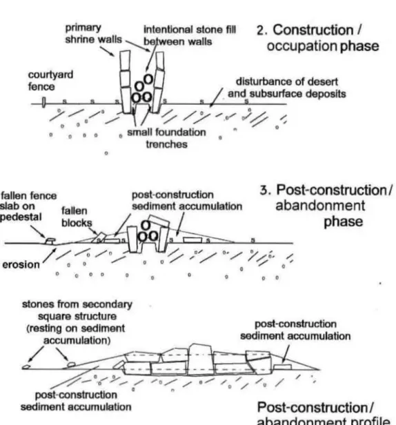
clear developmental sequence in the sire formation (fig. 11 ). This is summarized in four stages:
Fig. 9. Ramat Saharon1m Shrme 4 stratigraphy photo-graphs; (A) Section C·F/425-426; (B) strat1graphy ol sec-ondary structure in Square F35.
Stage l- Pre·occupat1011 (fig. 11 · / ): The land -scapc is essemially n:u. with a cover of <>mail gravel
(2-5 cm: desen pavement). Lhe uppermosl part of a
young <lesert reg soil. unJcrlafr1 by the gruvcl-free A
horizon comprising fine sand and silt (Amil. H
arri-son, and Enzel 1995) and cssentially the modem land surface beyond the immcdiate proximity of the
shrines (Su-atigraphic Unit 1). The uppem10-.1 reg soil
developed on top of an crosional surface. wh1ch
trun-cate a late Plcistocene calcic paleosol. charnctcri~ed
by carbonate nodules within a red silty mu1rix that
developed on a sandy--.ilty unit of the Juras-.ic lnmar
Formation.
Stage 2-Co11structio11 a11d initial 11~e <JiR. 11 :2):
Thi phase conSÎ'>t'> of Lhe construction of the
pri-mary double watt. ca. 1.5 m h1gh. Il '' al-;o po~sible
that the counyard fcncc was constructcd al &hi-. lime.
but there is no tirm evidcnce conccrning th1..,. The
ac-tivities in and around the shrine destroycd the desert
pavement (Stratigraphie Unit 1). leaving only the soft and porous sill and sand A horiton of the reg soil
and underlying palcoi.ol (Stratigraphie Unit IV).
During lite course of u~c. one may a~surne some
maintenance and repair, perhups even cleaning.
Ac-tivit1e~ around the o;hrine would have tended to r
e-duce the accumulat1on of ..,cdirnents. One heanh was
pre.,en1 on the original land -.urface in clo'\e
prox-imity to the shrine wull (Sq. 432E). and charcoal.
perhap~ from another hearth not preserved, was r
e-covered from the surface a few meters south of that
(Sq. 422F). The watigraphic contex1 of the hearlhs.
and the1r proximity 10 the wuJI. i strong cvidcnce
that they arc in fac1 asc;ociated wilh shrine activitic!..
SttH(<! J-Aba11do11111e111 lj1!(. 11 :3 ): With the
ces-<>ation of activitics around the shrioe, the massive
double wall actcd ai; n sand trap. accumulating wind
-blow11 sedimcnts (Slrntigraphic Unit Lli) all around
the structure. like a dune. abovc the original l:rnd sur
-face (Strutigraphic Unit IV). The higher elemcnl!. of
the <ihrinc. now in disrepair. foll onco the:.e scdiments
al diITercnl ...iagc of accumulation (in fact. bcgin-ning carly. presumubly i-.hortly after abandonment). The accumulation of "ediments abuning the primary
wall Ît'ielf constitutes a significam change in
topo-graphie relief in the previou~ly na1 landscape. and
alrhough the court}urd wall reslricted dnunage in
Lhe hort term, the double wall change:. the basic
drainage pallems. rcsulting in increru.ed eroi.ion
be-yond the 1onc of accumulation. The de. truction of
the original dei-ert pavement in the v1cinity of tht>
structure also cxpo~c" unprotected areas to wind d
e-natio11 and to local cro-.ion caused by runoff (from
lhe increu.,.ed relief) during the infrequeot rain events.
This cau,es the stones of the counyard fence to
1opplc. and after the upright stones have fallcn.
ped-esrnli- are formed (ai. a consequence of difîerential
erosion/Jcna1ion cuuscd by the proteclion offered
the follcn stones) on which some of the counyard
fence stones still rest (fig. 11 :3). Huma11 dc.,tru
c-tion muy al~o play a rolc here as well, givcn Lhe widcly scattcrcd di tribution of the courtyard fcnce o;tones. whicb i~ difficuh to cxplain by natural pr
o-cess alune.
Sta!(e 4-Sec:ondarv .w·11ct11re co11s1rnctio11 (jig.
11 :3 /ower): The sediments accumulating adjacent
to the primary wall create a 1>lope also on the north
and 'lOuth ends of the structure. uJtimately capped
by the 'urface cru-.t (Stratigraphie Unit Il). Round
conglomeralc cobble~ of the subi.idiary tructure
are placed on these accurnulationi.. resting in and abovc Stratigraphie Uni1 li (figs. 9. 11 ). Therefore,
Lhcy mulil postdate the double wall construction by
i.ome i.igniticunl span of timc, probably thou aods
Section ~--OS 0 Sec1lon 43Cl-OI ~
·
-..::::::::;
~';--'-:
·
~
·
·
::::i
1
...-:
·
~
••
·
·~L
I
Il 0 c Section 423-424.
..
'
".
.
.
0 Section 417""'818 0 e;:;J:;cz;s1\
.
...
. .
'.
.
I
. ""' ~ c DFig. 1 O. Ramat Saharonlm Shrine 4 section drawlngs.
0(1, 4pl - ~ B E F O(; H ~ •o< b e 1
~
~
~" 0 4160
3,If'
2 .1~, 17 170'
12S 1 0 ~ ~ i-m 185 ~ ~ 0 196 r::;C (\ ~ l:M 9 [189 89_
q;t
:Q
33 .,~ 8 Il 0' 7 35 190 [' r} 6 130 1 101'"
01 's
.~<l
';J'- J3 4 ~ri-1 1~
3 4 1~ 3r ~ ~ 2 t l!-.t,.
...
,
,
_JIJ/Of O 1!tl
~ 11 1 .,.. Il 0 ( l~
ns
9 117 "~ '(1fa' 1) 1 !l 8 12 ri~() 7 31 il~ 6~
... ~ j;)s
....__
'
.
,,
0_
Jj
~ ~ ':J 1 l 4.
\' ..J 1 8 1o; 43 43 43 43 4342
42
42
4242
42
42
42
42
42
41
414
1
41 41 4141
41 3 j j,__~
IJ .2jb71J
Secdon 427-'f28A
.
.
•
çRamat
Saharonim
Shrine
4:
Schematlc of Phases of
Construction
,
Occupation,
and
Deposition
stones / desert pavement
s 8 • 8 8 a a 0 • 0 8 s s s a s 8 s original surface
/ / / ,.. //-///"'//~ 4/'sand/loess
o o / 0 0 ' / " ' o ' subsurface
0 0 O O 0 0 0 0 0
o - - - Pleistocene paleosol
1
.
Pre-occupation stratigraphy
wlth CaC03 nodulesprimery fntenUonal stone flll
shrine
~ls
:--.roeen walls2
.
Construction I
occupation
phase
courtyard
0
fenœ
0
dlsturbance of desertend subsurface deposlts
,,.-~~..._---~--~~
/
"";./·,,,,,,,
-/
/
/
/...
)
~
...;
, 0 0 smell foundation " 0 0 0 0 0 tranches 0fallen fence post-construction
slab on fallen sedlment accumulation
3
.
Post
-
construction
I
abandonment
phase
pedes~ bl~k
't
_
Lr,ef::;;J__
.
/e
/~/~/
~
7,
-:-
/,
-
;
-
.
-,,.-eros1on o o / 0 "' ,... " / , 0 0 0 0 0 0 0 0stones from secondary
square structure .
(restlng on sedlment post-constructton
accumulation) sedlment accumulation
/
~~
~/
" o / / ,,...- , , o / / /u / / ·, post-constructlon
°
"
sediment accumulation
Post
-
construction
/
abandonment
prof
i
le
Fig. 12. Tumulus 28 looking west. wlth Tumulus 29 ln the background
EXCAVATION OF TUMULl 28, 29, AND
30 0 THE SOUTHERN RIDGE Tumulu 28. Tumulus 29. and Tumulus 30-ihe
westernmost 1umuli on the Southern Ridge (figs. 2.
12)-were excavated. Excavations wcre conducted from the top down inlo the cist of each 1umulus s-uch
that the structure of each was left iniact. A 11 sedi· ments were sieved through 2-lO 3-mm mesh.
The basic llLrucLure of the 1umuli is idcntical to
that describcd by previous scholars {e.g., Haiman
1992: 1993). Tumulus cons1n1ction begins with 1hc excavation of a shallow pit-in the case of Ramm
Saharonim, no more 1han 20 cm deep due LO the sh•ll·
low dcpth
o
r
surface sedimcms on the limcstonc lay· ers or the Ardon Formation. The interior wull of 1hc turnului:; was Lhen constructed around the. hallow pit. A ring of large margin stones was placed dellmiting1he ou1er edge of the tumulus. The interior c:îst was constructed using horizontal slabs of varying lcngth!. 10 forrn a rough oval or polygon. At some point 1hc body (or bodies) wcre placed in the ci:.L. and !.lab:-. wcre placcd over il (or them). The massive super· structure of the tumulus, bctween the wall of lhe cisl and the margin stones. was con. tructed more hap·
huardly. Il is likely tbat the cist wa.<; also covered in the process of building the superstructure, although
it is difficult to detcrmine wbether the tonet. ln the interior are întentional fill or fall. Given the repcmed
use of the tumuli. accessibilily lô the cist must have bccn considered in construction.
The excavation revealed remai_ns of seven in· dividual.;;;1 six of whom could be associated witb the pcriod of the construction of tbe Lumuü. The seventh, round an 1lw upper level of Tumulus 29, clearly rep·
re~cnt!. a Inter reuse of the tumulus. and indeed lies almmt
a
metcr above the very poorly pre erved re· m111ns of an inûividual on the lowest surface of the tumulus.1'11 Ill""' s 2 8
Tumulus 28 has a relatively small cist opening at 1.75 m (nbovc dnium). wilh a rectangular shape ori·
en1ed northwest-southeast. From the top. the cist
narrows fmm 0.70 tu 0.60 min width. but increases
frorn 0.85 10 1.20 m in length. A few isolated human
boncs werc round as high as l.65 m. being probably
movcd hy later ùisturbance. The main level of bone wns fCJund from 1.25 10 1.13 m. Two di fferent areas. the !ICluthcaM and the nonhwest. were clearly recog-nizc<l during the dig. Scattered fragrnented bones mixcd wi1h numcrous maJI slabs and stones (fig.
13A) fi lied the southeast half of the cist. At least iwo adult individual!. wcre pan of this assemblage. At the bottom, a right hand wa'i fow1d connecced in a dor al
po~ition anJ arcîculated to an ulna. Severa! anatorn·
ical ly cohcrent asscmblages-thoracic venebrae clus-cered w1th rios. a skull fragment on top of an atlas,
'A llltJrc Jc111l11.:d phy~ical anthropological report is undcr prepunuion.
Fig. 13. Tumulus 28: (A) view of clst before exposure of skeletal remelns: (B) view of lower part of articulated skeleton
ln northwest hall of cist.
and a mandible wilb a hyoid bonc- were also un
-covered. Thal is. Lbere was at least one primary in
-humation in thi~ area. cven if major disturhances
destroyed the buriaJ(s) aflerward. The northwei;t halr
of the ci 1 was protected by a large lab. The removal
of this slab revealed Lhe lower part of a skeleton
(from the fourth lumbar vertebra to the feel) in full articulation (fig. 13B). Preliminary examlnalion in
Lhe field suggests these are the remaini. of an adult
male. lying on his back with the legs flexed on the
Jeft side, perpendicular to the vertebral column. We
assume Lhat the anacomical clusters seen in the south
-cast half of the cist are part or the samc individual. The body was otiented in a southeast-northwest di
-rection. wilh the head against the !.outheast wall of
the cist. Beneath the bonei., the surface of the cist
was carefully paved with large and medium-sjzed
slabs (fig.138). Tumulus 29
Tumulus 29 has the largest cist or the lhree tumuli
excavated ( 1.60 x 1 .10 m). The opening is pentag-onal in shape. oriented norlheast-southwei.t. The
highest point of the tumulus is al 2.12 m. and the
highest human remains were discovered al 1.68 m.
At this level, a weU-preserved and complete skeleton of an old woman (over 60 years old) wns found. The
body was placed on the left lateral side with the head lifted up (fig. L4A). The legs were nexed as well as
the arms. which were tight to the body with the right
hand under the chin and the tert under the thorax.
Pieces of desiccated leather ·urrounded the whole skeleton. uggesting burial in a tightened sack. or
shroud. Arouad the skull, pieces of a different k.iad
of organic macerial. perhap rope made of vegetal
Fig. 14. Tumulus 29: (A) view of upper skeleton, a
second-ary use of tumulus, (B) the lower scatter of bones.
fibers, wcre ulso found. The excellent state of
pres-ervation, the pre ervation of Lhe leather. and the high
location in the tumulus suggest thar this burial wa ··iocrusive·· to the tumulus. as reflected clearly in the
Fig. 15. Tumulus 30: (A) central cluster of bones wlth wall affect on south sida; (B) closeup view of articulated foot.
second half of the ftrst millennium B.C.E. (see larer
discussion). The proximity to the Nabataean spice
route (e.g .• Cohen 1982) suggests a Nabataean cul -tural attribution.
Under tllis skeleton, che internai structure of the cist was organized with slabs one on top of rhe other
filling the east half of the cist down 10 the bottom of lhe tumulus and a fill of infiltrated sandy matrix on
the wcst side. in which a second cl us 1er of hum an re-mains was found between 1.02 and 0.89 m high (fig.
148). Only about 40 bone fragments, in a very poor
statc of preservation, were found scattercd. These inclùde pieces of long bones. vertebrac, ribs, and
teeth. More detaîled study is necessary bcforc a1
-tempting to ioterpret this assemblage in terms of
funerary treatment, but there is no doubt that this is
part of the initial use of the tumulus. Small slabs
paved the bouom of the cist immedintely beneath
the bones.
Tumulus 30
Tumulus 30 is 1.84 m high. The opening of the cist (0.95 x 0.75 m) was pentagonal and oricnced nonheast-soutbwest. The cist was fillecl by infil
-Lrated sedünent almosl ro the top. lts internai stnu
.:-ture was organized with two rows of slahs one above
lhe 01her on lhe north side from 1.36 to 1.19 m high.
Slabs were absent from lhe central part of lhe cisL,
and the south edge of these areas is filled only by sediment. A few isolaced bone were found between the slabs al the northwes1 corner of the cist, bu1 the
major layer of human remains was round henemh
Lhe level of the slabs in the central and north part of
the cist. No bones were round on the sou1h side,
and a very clear "waJI effect" is shown (fig. 15A).
This cou Id be eitber the resull of a perishable stru c-ture. which prevenred the dcposit of Lhe body or bones in tbis area, or the result of a specific
tapho-nomic process in tbis area thaL destroyed the r e-mai ns :tfterward. In fact. the alignmenl of che bones
at the limit of the empty area suggests that the exis
-Lence of a hard perishable structure, now gone, is the
most likely bypothesis. Analyses of Lhe sedimem
samplcs taken Crom this area will help to answer this
quei.tion.
The level of bones was approximately 20 cm thick. lsolated bones were mixed with parts of artic -ulmed skelecons. Ali catcgories of bones are pre s-ent: long bones, skulls and mandibles, hand and foot
bone~. girdJe. and thorax. A minimum of three adult individuaL<; i present in the assemblage. Al Ica t 1wo
of them remain parrially articulated at the bollom of the pit (one complète left foot and leg [fig. 1581, one
complete right hand and forearm. and a skull articu
-Ja1ed with the mandible). but later disturbance does not allow reconstruction of lhe original position of the bt)die~. The few additional remains suggest Lhat a secondary burial was also made in Tumulus 30.
Ac-cording to the disturbancc&, the cist was visited s
ev-eral times for funerary purposes. and the burials were
probably not contemporaneous but successive ones.
The final stage of the grave. with two skulls lying
agains1 each other and a cluster of long bones ut lhe center of the cist. is certainly a deliberate reorgani
-zaLion of the bones. Eighc Conus sbells, with holes
drilled in the Hat end to form beads, were also r
e-covered at the burial level. Four of lhese were round in a cluster becween foot bones in articulation and a
skull (fig. 158).
The bones in Tumulus 30 were resting in a s hal-low basin filled wilh stony sediment. The bouom is
T ABL~ 1. Radiocarbon Determinations 14C Age±
Context lu years Lab code (square, depth) 1}•pe 8.P. RTI466J Shrinc 4 Chorcnal Cll1SU~40
( 422F, 1.40-1.42)
RTT4665 Shrine 4 bearth Chun:oal 5945 ±45 (432E, 1.94)
RTI4664 Tumulus 29 L.:ulhcr 2225 ± 35 Upper burial
situaLed in t:he middle of Lbe cist, l .OJ m ltbove da·
Lum, at approximarely the base of the tumulus ilself.
Al this level, the cist was much larger Lhun Lbe upper opening ( 1.30 x 1.50 m). Under the basin, a Sandy. oft sediment was present. sîmilar LO lhe sediment covering t:he upper parl of tbe cii.t.
Summary ·a11d Discussin11
The excavation of 1he westernmost tumuli of tbe
Southern Ridge reveals well-preserved cist burials. Two are pentagonal-shaped with a major axis ori
-en1ed northeast-southwest Jike the shrines, and Lhe
Lhird one is rectangular with an axis perpendicular to 1he previous ones. ln each tumulus. human r e-mains were discovered, clearly associated with Lhe
initial construction of the cist. with slab covers and/ or pavements. At least six adult individuals were
bur-ied in tbese three rumuli during the Laie Neoli1hk. Severa! Lhousand year la1er, Tumulus 29 was reused by Nabataeans (mos1 likely) for the inhumation of an old woman. The Neolithic remains are very poorly preserved, and the bones crumbled on louch. At leas1 three burials were primary inhumations. With
the exception of the half skeleton in Tumulus 28. whicb was well pro1ec1ed by a large slab, the original
position of the bodies at burial could not be recon-structed because the Neolithic people reorganized
the boues after the decay of soft tissue. Neverth e-less, given the arriculated anatomical clusters al the base of the cists, il is clear that the bodies were not
covered immecliarely by sedimenl. The stale of pres-ervation of t:he articulations shows thal the decay
oc-curred in an empty space, allowing small movements
of the bones during the process of decomposiûon. More likely. and in accord with geomorphological analysis (see discussion below). the bodie!l were cov-ercd by scooe slabs and the sedimenl infiltrated the graves Jater. Secondary burial is also likely to have been part of funerary customs at Ramat Saharonim.
Calihrated Calibra1ed guc
age B.C age B.P. %oPDB 5210-5050 (68.2%) 7170-7000 (68.2%) -24.6 5280-4990 (95.4%) 7230-6940 (95.4%) -1910-4730 (68.2%) 6860-6680 (68.2%) (-23) 494()-4710 (95.4%) 6890-6660 (95.4%) 180-200 (68.2%) .23'.l0-2150 (68.2%) -20.4 390-200 !95.4CK) 2)4()-2150 (95.4%)
at leasl in Tumulus 30. This tumulus is the best pr e-servcd and seems not to have been reopened since Neoli1hic limes. The state of preservation of the scat -1ered remains in Tumuli 28 and 29 are more difficult to interpret as secondary inhumations because the poor slate of the assemblages could also be 1he result
of taphonornic processcs.
Although dst burials are also known from Ponery Neolilhic contexts .in Jordan (e.g., Banning 1995:
1998: 224). tJ1ey differ in numerous particulars. in -cluding social context (sedentary fanning villages),
the presence of grave offerings like pots. the exclu -sive pracLicc of prima.ry burial. and the absence of tumulus superstructures. These contrasts undo ubt-edly reflect the fundamenlal contrasts berween the
lifeways of Lbe desert and the sown.
Finally. iris imporcanl to emphasize that the burial remains from Lbe Ramat Saharonim tumuli suggest a closer behavioral relalionship with Lhe Sinai nawamis tombs than previously assumed. Wbereas previous assessments teuded 10 view the tumuli as single-epi
-sodc. single-burial tombs. in significanl conLrast to the nawamis. Lhe reused and multi-burial iumuli at Ramat Snharonim suggesl similarities not recognized
in earlicr studies.
ABSOLUTE CHRONOLOGY
fn the virtual absence of malerial culture remains associal'ed with the Ramat Saharonim complex, two
independent methods of dating, L4
c
and OSL, werenssayed in order to place the site in historical coo-texl. A dctailed discussion of the methods and resullS has been publisbed elsewhere (PoraL et al. 2006), but a review bere will allow better evaluation of the
dates in light of lhe detailed site description.
The melhod of radiocarbon dating is well knowa
(e.g .. Mook and Waterbolk 1985; Ramsey 1995), and the results of the de1ermina1ions are presented in table 1. The two dates from Shrine 4 derive from
charcoaJ fragrnenlS associated with the contact bc
-t ween Units Ill and fV, that is. the original land
sur-face associated with the construction of the shrinc.
They clearly place Lhe construction ca. 5000 cal B.c .•
the Late Pouery Neolithic in standard Levantine
chronological tcrminology. and Lo the early phase of
the Timnian in Rothenbcrg's (e.g .. Rothenberg and
Glass 1992) desert framcwork.
Although both dates dcrive from wcll-controllcd contexls, RIT-4665 from a 'lmall in siru heanh and RTT-4663 from a concentrntion of charcoal on the
original land surface, givèn only two dmes (the rotai
charcoal recovered). it i, difficult to as~css the minor
differcnce betwecn them. Although they overlup ut
the 2-sigma confidence imcrval, in gcneral lhi:: con
-struction of four shrines nnd 30 tumuli supports the
likelihood that the span in the dates renecrs a long
period of site use, implying that the differencc 111
dtues is meaningJul.
The 14C date for tJ1c upper buriul in Tumulus 29
·uggest a Hellenistic/carly Nabarnean reuse of the
tumulus. Beyond dating the burial itself, and po
s-sible implications for :in early use of the southcrn
spice route. the relativcly dose agreement between the t.ic determination und the OSL date (sec
he-low) lends grcater confidence 10 the chronology in
generaJ.
Luminescence dating rnethods (Aitkin 1998) date
rhe las1 sunlight exposurc epii.odc in à minernl's hi:-.·
tory and use signais thm arc acquire<l by minerai
grains such as quartz or fcldspar from the natural en
-viron mental radiation. The magnitude of OSL signal
is relatcd 10 che touù radiauon rhat the $ample rc
-cei ved. Sincc the OSL signal is ensirive to sunlight,
exposure 10 1he sun during lranspon and deposition
of the sedimem will reduce ihe previously acquirec.J
OSL signal 10 zero ("blcaching''), and after burial it
will grow again. These mcthods are used ex1e11:.ivt:ly
for dating Late Pleistocene 10 Holocent! aeolian. allu
-vial. fluvial. and colluvial sedimcnts, nncl major ap·
plicatioas include paJaeoseismology. palaeoclimatc.
land cape evolutioa. and prehistoric sites. ln order
to date an archaeological installation, one needi. w
sample sedimems (preforably aeolian) deposited cloi.e
ro the lime of construction that are likely Lo have
becn exposcd to unLight. Appropriarc ·edimenl con
-texts include two basic types: ( 1) sediments und
erly-ing stones used for construction whercin presumably
the uppermost sand grains were exposed 10 the sun
prior to the placement of stones. 1hus providing a
maximum luminescence age for the site, and (2) sed
-iment füling interstices betweea construction stoncs
which prt:sumably accumulated soon after the
con-struction or abandonment of the site. This age will
be a minimum age for rhe sire. By combining the two
typei.. the age of the site can be constrained.
The need for alternative dating merhod terns Erom the anticipated paucity of charcoaJ on lhe site.
and indeed. the OSL date. provided lhe only means
of daring the earlicr phase of tumulus construction
and use. The details of the methods as applied to Ra
-mat Sahuronim arc published el ewhcre (Porat et al.
2006; also see Por:u 2002). Briefly stated, 1wo tech
-niques were employed, one utilizing single aliquots
Con the tumuli and the shrîne) whereby a large num
-ber of quurt7 graini. (several thousands) are measured
LOgether, and the second 11tilizing single graill analy
-ses. Results arc summarized in table 2.
With respect to the tumuli at Ramat Saharonim.
one can c;afely assume that ail the scdiment within
thcm, betwcen the slabs abovc and below the burial •
and be1wccn Lhe srones of the cist walls. accumulaled
after burial (see Porat et al. 2006 for detailed discus -sion). The bodies were not covered with soil. as no
soil is nvall:lble in the area. but with Stone slabs (sce
aJso discussion of <;kcletal remains above). The infil
-1ra11ng grains arc fine. wind-bome. and were blown
into the tumulus Lhrough gaps in the stone,. There
-forc. 1hcy were mosr Ukely well bleached ut the tirne
of dcposition, <U1d their age would give a minimum
ag.e l'or buriaL
The i.ample cottected from the ame level as the
skcl~ton in Tumulus 28 (RS-8) gave an agc of 6000
± 600 ycurs B.P., a11d a second sample (RS-9), taken
2 cm lower, gave 7500 :t 700 years B.P. ln Tumulus
29. the <;ample lRS-11) from the sediment
underly-ing the feet of the skeleton gave 1800 ± 170 yeari>
B.1> .. while a second sarnpJe fRS-10), taken from under
<• tone in the wull of the cist. from the same level as
the upper. well-preserved skcleton. gave un age of
2000 ± 200 years B.P. Evidently. the two burials are
of differcnt ages, supporting the idea of secondury
use of Tumulus 29. As these ages are from sedimems
depoi.11ed after burial. the burial in Tumulus 29 took
place ahout 7500 ± 700 years ago, and the b11rial in
Tlumllus 28 about 2000 ± 200 years ago.
ln the shrine. both pre- and pos1-construc1ion ed
-imcnr., were identified. At the time of construction,
the uppcnnosr pan of the surface sediment on which
the sroncs wcrc placcd was disturbed and mixed.
exposing a layer of several cenrimeters 10 sunlight
(a bimilur process happened during the excavation.
when a large number of people treaded the surface).
con-TABLE 2. Summary of Op1ically Stimula1cd
Luminescence (OSL) Dates S111,f?le Aliquot Mt'fH1tre111et11J
St1111ple Deptlr (111) De (Gy}
Slmne 4: RS·I 04 268±7.9 RS-2 0 -~ -Il 2± 11)5 RS-3 04'i :?O.ll±7 6 RS--1 () ~ 16.8±5.5 RS-5 0.-1 73±21 RS-6 0,5 l l 9±2.5 RS-7 0,2 234 ± 19 "/1111111/i T28 RS-8 O.H 118±1.2 T28 RS-9 U.H 147±1.4 T29 RS-10 () 7 3 :'il: 0 35 T29 RS-11 0.7 ) 0±0.27
Single Grain Mem11re11w11t,f No. 11/ De (Gy) Somple grc111u Main peak
RS·l 12Œl -17± 1.4 R ·2 3!17.l 8.2± 2.6 RS·J 271.16 5.4 ± 2.4 RS-l 30/40 5.1 ± 1.5 RS·5 9142 5.4 ± 0.7 RS·6 23/34 6 1 ±2-6
struction. when the placement of stones ~caJed the
sedimcnLS off from furthcr exposure to sunlight. Af
-ter construction and ab<indonment. sand accumu
-la1ed along both sides of the main wall. Luter. stones
collapsed and covered the accumulatcd sand, seaJing it from further exposure. The sanJ under the col
-lapsed sloncs and between standing stones will give
a minimum age of construction.
Ali single aJiquot analyse& from the shrine showed
a very large intra-aliquot sample i.caller (table 2).
The ample with the highest c;catter and olde~t ages
are th.ose that wcre collec1ed clo<>e 10 the base uf
the site. from the layer tha1 was d"turbed during
~ite construction. One obvious rea<;On for Lhe e large
scaner and old ages is thai in 1.>ome
or
the sedimentgrains. the OSL signal was not fully rcset during
transportation. and thcy carried a c;ubi.tantial resid-ual signaJ at the timc of deposition. The aJiquot with
1he lowesr dose equivalcnt (De) would contain the
Axe (ka) YmmgeH age
Dose rate H.P. (~a) H.I'.
1122 ± 66 23.9±77 12.5 l:.?TH.!4 J2 4±81 19 7 !071i 2.1 20.8±7 l 9 l 9110 ± 60 17.2±57 q4 121K ± 76 60± 18 41 991 ± 23 12.0± 2.5 iUl 15·1Jl 76 152 ± 14 (il) 197H1R 60±06 1960 ± 28 7 5 ±0.7 1714 ± 2'1 2.010211 IM0±26 1 8±1117 A}le(ka) Dose "''" H.I'. 1122 ±66 4
z
± 1.) 1173±24 6.4 ±2.1 1071.123 5.U± 2.2 9ll0i60 5.11± 1.6 1211! ±76 4.8±0 8 991±2.1 6.1 ±26largc1.>t proportion of well·blcached grains. and Lbe
age culculaled from it could indkate the true time
of deposition. For each samplc. such an age was c
al-culated from Lhc lowcst aliquot (table 2). giving an
age range fur the samples from 41.000 to 8800
years o.P. So. cvcn the age calculated from the
lowei.t De values arc very scattered and probably too old, considcring the age ob1a1ned from the tumulus. the radiocarbon dates. nnd the archaeological evi-dence. Apparently. evcn these youngcst aliquots co
n-tain graini. nol rese1 at the 1ime of depo i1ion.
Single grain measurcmems (B01ter-Jen en et al.
2000) of huntlrcdi. of individual grains from the
shrine howed a mixed population of young and old age1.>. For each <;ample. 1hcre is a distinc1 peak distri· buLion in the young ages (4000-6000 years 11.P.) with a tail of older grain1.> (~ee Porat el al. 2006). This con· firm~ our inference from the '>ingle aJiquot meas