HAL Id: hal-00464563
https://hal.archives-ouvertes.fr/hal-00464563
Submitted on 17 Mar 2010
HAL is a multi-disciplinary open access archive for the deposit and dissemination of sci-entific research documents, whether they are pub-lished or not. The documents may come from teaching and research institutions in France or abroad, or from public or private research centers.
L’archive ouverte pluridisciplinaire HAL, est destinée au dépôt et à la diffusion de documents scientifiques de niveau recherche, publiés ou non, émanant des établissements d’enseignement et de recherche français ou étrangers, des laboratoires publics ou privés.
Upstream floods and damages : heavy rains. Example of
2 december 2005 at Nice (France) and mechanisms
analyse.
Pierre Carrega
To cite this version:
Pierre Carrega. Upstream floods and damages : heavy rains. Example of 2 december 2005 at Nice (France) and mechanisms analyse.. Upstream floods and damages : heavy rains. Example of 2 de-cember 2005 at Nice (France) and mechanisms analysis., Jul 2006, Timisoara, Romania. cdRom 10 p. �hal-00464563�
Actes du 2nd International Symposium « Preventing and Fighting Hydrological Disasters ». 29 June 2006 - 01 July 2006. Timisoara. ROMANIA
Upstream floods and damages : heavy rains. Example of 2
december 2005 at Nice (France) and mechanisms analyse.
Pierre CARREGA
Professor at University of Nice - Sophia Antipolis (France). Environment Team of UMR “Espace” - CNRS
carrega@unice.fr
Abstract :
In this paper a heavy rainfall event which causes damages is studied. Rain quantities > 200 mm in 12 hours (100 years return period) were exceeded in some locations of Alpes-Maritimes Department (South – East of France) and of Italian Riviera. Such important quantites are due to two main factors : first is a high water vapour quantity (because of Sea Surface Temperature) available for condensation and precipitation. Second is strong vertical air ascendances caused by vertical thermal instability, important orographic effect,and powerfull cyclonism and vorticity. This event was very well forecasted by the Italian Bolam model, available on Internet, that allows to understand the weight of each component.
Keywords : Heavy rainfall, damages, meteorological situation, SST, vertical air ascendances, model.
Introduction :
Floods are often considered as hazard part of natural risk, and also the damages caused by flood are considered to depend upon vulnerability.
In fact if we want to have a chance to modify risk and damages (in term of human lives and costs), a flood must be considered as the result of the capacity or, more accurately, the susceptibility of the environment to transform fallen rain in a flood. The intermediate role of topography (especially slopes values), of ground permeability, of vegetation cover, etc. constitute the susceptibility. This is a parameter on which we can act at least a little (but less than on vulnerability). Thus, the only parameter on which we cannot act is the real hazard : rain (not flood). And this is why it is necessary to get the best possible forecast of dangerous meteorological situations.
1- Description of the event :
The study takes place in the Department of Alpes-Maritimes (South-east of France) the main town of which is Nice, on the French riviera. It is a mountaneous region, due to the south end part of the Alps at the sea contact, with altitudes > 1000m at less than 3 km from the sea at east of Nice, and > 3000m at 45 km from the sea.
Weather is fine and sunny on the beginning of december 2005, after a period which was not rainy enough : 56 mm for november (instead of 100-120 for average monthly values), and only 4 mm in the previous 15 days.
In this mediterranean region, the maximum rainy season is on october and november, but december can sometimes be rainy, because of the still warm temperature of the sea when dynamic depressionar circulation occurs. The atmospheric pressure is near to normal value the days before this rainy episod, with very clear sky on the previous day, 1st of december. On the 2nd december morning, weather is wholly cloudy and some
weak rains occur before noon on the region. In fact, it is just the beginning of a weather cyclonic perturbation which is moving from West to East and which gave some rain on western part of the domain, but not too much. One of the interests of this perturbation is that it will increase and enforce, during its movement on the studied domain on the afternoon with the strongest moment about 9 pm. On midnight (12 pm ,2nd december) the main part of the rainfall is finished.
Fig 1 The Department of Alpes-Maritimes (right), at the South end of French Alpes (left).
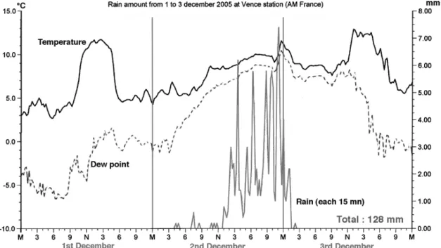
Fig 2 Rainfall episode at Davis station of the author, Vence 323 m altitude, Alpes-Maritimes.
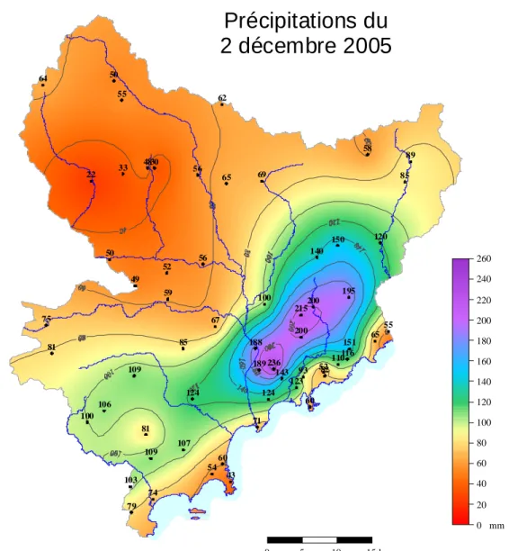
In fact, more than 90 % of the rainfall occurred in less than 12 hours, as it can be seen on the fig 2. But the total rain amount increased in the east part of the domain and especially in Italy (out of map), where rainfall exceeded currently 200 or 250 mm in the Imperia region. In the Alpes-Maritimes, amounts > 200 mm were reached,with 236 mm as higher value as indicated on fig 3 which uses kriging technique, and the most rainy area is located on the beginning of first important relief, at few distance of the sea.
Fig. 3 Total amount of 2nd December rainfall on Alpes-Maritimes. Data from MétéoFrance. Krigging technique mapping by W. Berolo, modified by P. Carrega.
These values > 200mm correspond to centenal values, i.e. daily rainfall the return period of which is about 100 years.
43 54 60 52 236 215 4830 67 120 74 188 109 200 85 64 200 82 52 81 22 62 100 140 79 55 65 109 150 71 93 124 143 189 103 151 116 49 33 50 59 75 100 55 50 60 69 56 106 195 124 123 110 107 65 81 56 89 85 58 0 5 10 15 km 0 20 40 60 80 100 120 140 160 180 200 220 240 260 mm
Précipitations du
2 décembre 2005
The consequences of these rains are various :
There were no very important flood for three main reasons :
- much of the rain was absorbed by the ground which was not saturated due to a sunny weather on the previous days ;
- the spatial gradient of rainfall recorded is very high : in some places, there is a difference of 150 mm on 5 km (!) so that the surface which received very important quantities is not so high ;
- this surface is on at the same moment on 2 catchment basins (Var river and Paillon river), that divises the runoff in 2 different directions.
In some places of Nice, for instance, quantities vary from less to 100 mm up to 199 mm (maximum), values not included in the map of fig 3. In the upper part of Nice it was recorded 139 mm in 4 hours (17 to21 h local), and in this district there were floods with water level up to 50cm in some streets (not in lower position) and a person disappeared. Numerous landslides were trigged in the whole region, and many roads closed for weeks. Rare event, the Nice-Côte d’azur airport was closed for 6 hours and 50 flights cancelled.
We can show now that this rainy event could be forecasted using only free meteorological models available on internet sites, and due to the danger and risk, we made a forecast bulletin on www.meteosudest.org, before this event.
2- The components of the heavy rainfall.
A rainfall is always the result of two main factors familiy : - The water vapour quantity contained in the air mass,
- The possibility for this water vapour to climb, because ascendance causes clouds and rain.
2-1- The water potential :
The air capacity to contain water vapour is a mathematical function of air temperature. Above the sea, this variable is strongly related to sea water temperature, especially if there was not too much wind during the days before, and it was the case in our situation (no high spatial air pressure gradient). At the end of November, the Sea Surface Temperature (SST) is still about 15-16°C in the region, that allows an important amount of water vapor to be contained by air. In a first step this vapour is mixed with air by vertical turbulence, and in a second step, after condensation (cloud formation) it will feed rain.
The condensation occurs with refreshment due to air ascendance : all water vapour exceeding the capacity (linked to temperature) is condensed if there are nucleus (very small solid particles) in air. Usually, there are numerous in all south or South-West fluxes which come over the region, because of air mass flight over the Sahara desert, that will be the case on 2nd December.
Two variables show a rather important vapour quantity :
- Dew point measured on earth surface in all meteorological stations : it is about 10 to 12°C according to locations in the evening and the first part of night (fig 2), that indicates a marine air feeding ;
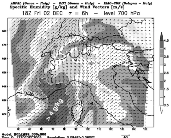
- Specific humidity (in water vapour grammes per dry air kilogramme) is important (fig 4) : it exceeds 4g/kg with a humid tongue shape upon the sea, enclosing Alpes-Maritimes,
in the map forecasted (6h before) for 2 nd December at 18:00 TU (7 pm local), at an altitude of about 3000m (geopotential 700 hPa)
Fig. 4 Specific humidity forecasted 6 h before, for the 2nd December, 7pm, at 700hPa level. From Bolam model. www.meteoliguria.it
2-2- The engine to condense this water vapor : air ascendance.
Gas expansion causes cooling, and cooling provokes condensation of water vapour excess. A cloud is unable to contain very much water, and, especially for convective clouds (cumulus, cumulonimbus), it must be considered as a suction pump which, at the same moment, is driving back water in so far as rain. Vertical positive ascendant movement is thus necessary to obtain rain, and in our case there are 3 reasons forcing humid air to ascend.
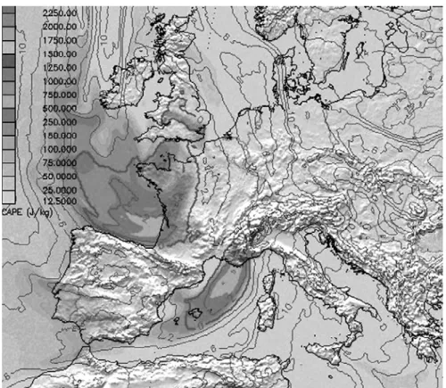
- i- Vertical instability given for instance by CAPE (Convective Available Potential Energy), calculated from radiosoundings. Air particles ascend because of density difference between warm air at low levels and cold air at upper levels, which lead to vertical convection with thunderstorm in extreme cases, as on 2 December where there are more frequent in the evening, > 20:00 UTC (fig 5). More, radiosoundings of Nîmes and Ajaccio (fig 1) which are directly concerned by this event show instability…
Fig. 5 CAPE forecasted for 2 December at 21 UTC. Model NMM. Univ. of Basel.
www.meteoblue.ch
Fig 6 Lightnings impacts analyze on 2nd December from 1 to 23 pm. From Wetterzentrale, modified.
- ii- The orographic ascendances are very important : the relief with steep slopes face to South in the department obliges humid air coming from the sea at all altitudes to ascend. This enhance the vertical positive movement (fig 1 and fig 4), and it explain the location of most rainy area : on the beginning of first important relief, but not too far from water source which is the sea.
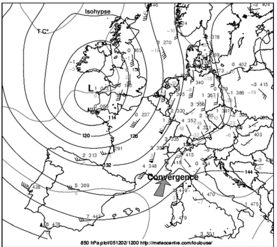
-iii- Vorticity or cyclonism expresses the air movement rolling up itself around air minimum pressure (depression), and ascending. It can be described and forecasted by Potentiel Vorticity Unit (PVU) model output maps, by helicity maps, etc.
An approach of this parameter is also given by the curve radius of the isobars, or of isohypses of geopotentiel, taking into account that most part of this dynamic ascendance is located in front of the depression or the cut-off, in south-West flux. General principle is the more the radius is small, the more the air convergence is important, at low levels (surface, 850 hpa), that provokes strong vertical ascendances for the air mass conservation. On the opposite, at upper levels (300, 250 hpa), divergence provokes an enhancement of the vertical motion, especially on the left exit of the jet-stream (fig 6, 7, 8).
Fig 7 Analysis of geopotential 850 hPa on 2 December at 12 UTC. From Meteocentre, modified.
Fig 9 Relationship convergence-divergence - ascendance - Fig 8 Analysis of geopotential 300 on 2nd December
at 12 UTC. From Meteocentre, modified.
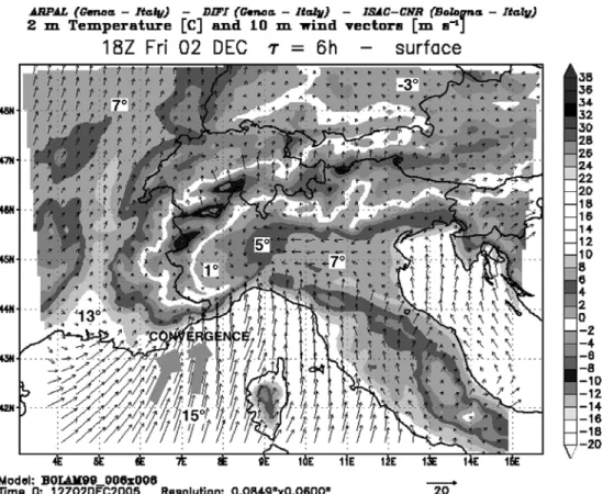
Fig. 10 Wind and temperature forecasted 6 h before, for the 2nd December, 7pm, at 2m / ground level. From Bolam model. www.meteoliguria.it
The fig 9 which is a forecast model output shows a strong convergence of wind vectors at the sea surface which, associated to vertical instability and important orography effect face to the flux at all altitudes (SSW to SW), explains the important rain quantities.
In fact, all dynamic factors linked to vorticity and cyclonism are very favourable to strong rains in this situation.
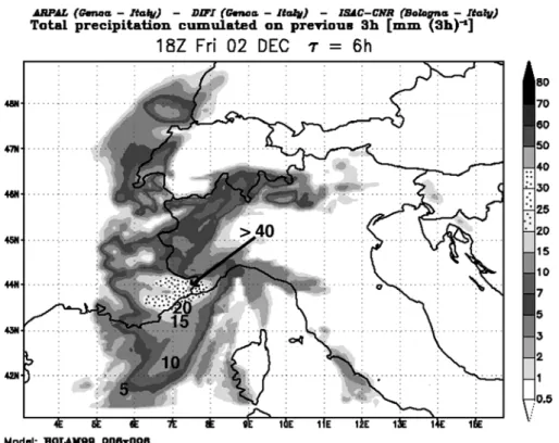
Map of fig 10 gives precipitations that were forecasted in 3 hours from 15 to 18 UTC (4pm to 7pm). As we have seen, these values were widely exceeded with more than 100mm/3h in some points of Nice just 2 hours later.
As forecasted, on Alpes-Maritimes, the main part of the perturbation was over after 23 or 24 UTC, but was at its maximum on the Italian Riviera. This map of fig 10 can be compared to the one of fig 3 which is an analyze, and not a forecast.
Fig. 11 Precipitations forecasted 6 h before, for the 2nd December, from 4pm to 7pm. From Bolam model. www.meteoliguria.it
Conclusion
According to different susceptibility and vulnerability, a same hazard as this important rainfall can provoke different damages. The relative low runoff due to relative soils dryness, the relatively small surface affected by very heavy rain, and the position of this area at the same time on two catchment basins explain there was not overflowing of main rivers. But there were flash floods in the city itself, upon the streets, and numerous landslides.
Thanks to the performance of Italian BOLAM model which gave a very good forecasted description of this event, this study case well time isolated from other rains or perturbations allows to assess the role of each rain component. Obviously, it appears that these phenomena are multivariate, as well as their consequences.
In this meteorological situation, water vapor presence factor was favourable to rain (less than in september but more than in february or march where SST is lower) ; vertical thermal instability was favourable, orographic effect was very favourable, and cyclonism and dynamic factors were also very favourable.
Finally it is very important to notice that all the documents necessary to understand and analyze the meteorological situation and to forecast the weather evolution are available on internet sites, and are free ! In all cases it allows to get a point of view in addition to that of every national meteorological service…
REFERENCES :
CARREGA P., 1995 : "Les précipitations et la situation météorologique responsables de la crue exceptionnelle du Var, le 5 novembre 1994". Nimbus, Societa meteorologica subalpina, Torino, n° 6-7, pp. 68-73.
CARREGA P., 2003 : « Les risques naturels liés à la pluie et à la sécheresse : élaboration de cartes des pluies extrêmes et des risques d’incendies de forêt dans une région méditerranéenne : la Toscane (Italie) ». Riscuri si catastrofe. T.II. (V. Sorocovschi), Universitatea « Babes-Bolyai », Cluj-Napoca, Roumanie, pp.271-286. CARREGA P., 2004 : « Heavy rainfall hazards » ; chapitre 8 du livre « Natural Disasters
and Sustainable Development », R. CASALE, C. MARGOTTINI. Springer, pp. 127 - 139 CARREGA P. , 2005 : Weather report on 2 december situation (forecast) in
Meteosudest : www.meteosudest.org
Meteoblue : www.meteoblue.ch Univ. of Basel Meteocentre : www.meteocentre.com Various maps. Meteoliguria : www.meteoliguria.it. Various maps.
MétéoFrance : climatological data of the stations network. 2 dec. 2005.
RAPETTI F., VITTORINI S., 1994 : "Le precipitazioni in Toscana : osservazioni sui casi estremi". Riv. Geogr. Italiani, pp. 47-76.
RIVRAIN J.C., 1992 : "La situation pluvio-orageuse des 21 et 22 septembre 1992 sur le sud-est de la France dite de "Vaison-la-Romaine". Météo-France. S.M.I.R./S.E., déc. 1992, 95 p.