HAL Id: hal-02283960
https://hal-univ-lyon1.archives-ouvertes.fr/hal-02283960
Submitted on 11 Sep 2019
HAL is a multi-disciplinary open access
archive for the deposit and dissemination of
sci-entific research documents, whether they are
pub-lished or not. The documents may come from
teaching and research institutions in France or
abroad, or from public or private research centers.
L’archive ouverte pluridisciplinaire HAL, est
destinée au dépôt et à la diffusion de documents
scientifiques de niveau recherche, publiés ou non,
émanant des établissements d’enseignement et de
recherche français ou étrangers, des laboratoires
publics ou privés.
Aqueous Processes From Diverse Hydrous Minerals in
the Vicinity of Amazonian-Aged Lyot Crater
Lu Pan, Bethany Ehlmann
To cite this version:
Lu Pan, Bethany Ehlmann. Aqueous Processes From Diverse Hydrous Minerals in the Vicinity of
Amazonian-Aged Lyot Crater. Journal of Geophysical Research. Planets, Wiley-Blackwell, 2018, 123
(7), pp.1618-1648. �10.1029/2017JE005461�. �hal-02283960�
Aqueous Processes From Diverse Hydrous Minerals
in the Vicinity of Amazonian-Aged Lyot Crater
Lu Pan1,2 and Bethany L. Ehlmann1,31
California Institute of Technology, Division of Geological and Planetary Sciences, Pasadena, CA, USA,2Université Claude Bernard Lyon 1, Now at Laboratoire de Geologie de Lyon, Villeurbanne, France,3California Institute of Technology, Jet
Propulsion Laboratory, Pasadena, CA, USA
Abstract
Amazonian-aged Lyot crater is the best-preserved and deepest peak-ring impact crater (diameter, D = 220 km) in the northern lowlands of Mars. Morphological features including scouring channels emanating from its ejecta and small channels within the crater have been examined previously to understand hydrological activity associated with the crater. In this study, we analyze images acquired by the Compact Reconnaissance Imaging Spectrometer for Mars on board the Mars Reconnaissance Orbiter to investigate the mineralogical record in Lyot and its surroundings, which are presently enriched in ground ice, to understand the associated aqueous processes, their relative timing, and a possible role for ground ice in hydrous mineral formation. Wefind diverse hydrous minerals, including Fe/Mg phyllosilicates, chlorite, illite/muscovite, and prehnite in Lyot crater walls, central peak, and ejecta, as well as in two craters to the west of Lyot. The exposure and distribution of the hydrous minerals suggest that they are related to the impact process, either exposed by the excavation of hydrothermally altered rocks or formed through syn-depositional hydrothermal alteration immediately after impacts. The Lyot impact induced channel formation to the north, but no mineralogical evidence of aqueous alteration associated with the channels is observed. The sinuous channels within Lyot, diverted by bedrock units with hydrous mineral detections, did not cause mineralization but likely represent the last stage of water activity in Lyot crater. The separate episodes of water activity indicateflow of liquid water on Mars’ surface during the Amazonian but limited to no aqueous alteration to generate hydrous minerals.Plain Language Summary
Though liquid water is not stable on the surface of Mars presently, water may have had a more active role on Mars in the recent geologic epoch. In particular, meteor impacts may melt ground ice, creating local environments with liquid water activity. Lyot crater is the deepest, well-preserved impact crater in the northern plains of Mars, with a diameter of 220 km, formed in the most recent geologic epoch. In this work, we study the mineralogy and morphology related to water activities within and adjacent to Lyot crater. One of the mineral types (prehnite) found in Lyot form at relatively high temperature (>200 °C) in hydrothermal environments. From the distribution of water-bearing minerals, we found that they probably represent an earlier episode of water activity before or during the impact. While liquid water has carved small channels inside the crater long after the impact, they probably did not exist on the surface long enough to alter the composition of the bedrock materials. Liquid water may be present but probably quite short-lived in the most recent epoch on Mars.1. Introduction
Mars throughout the Amazonian period is thought to be similar to present day Mars—relatively cold and dry with few indications of surface liquid water activity—as opposed to the Noachian and Hesperian periods, which are characterized by the formation of valley networks and large outflow channels. The widespread hydrous mineral detections made by instruments like the Observatoire pour la Minéralogie, l’Eau, les Glaces et l’Activité on board Mars Express and the Compact Reconnaissance Imaging Spectrometer for Mars (CRISM) on board the Mars Reconnaissance Orbiter (MRO) are also found mostly in Noachian- and Hesperian-aged terrains, while the youngest surfaces on Mars lack hydrous mineral detections at orbital scale (Bibring et al., 2006; Carter et al., 2013; Ehlmann & Edwards, 2014; Mustard et al., 2008). Together, these data suggest that by the start of Amazonian period, the widespread, global hydrological activity characteristic of early Mars had transitioned to a cold and arid environment where water changes phase directly from ice to vapor with few occurrences of liquid water. However, emerging evidence from orbital observations suggests that Amazonian Mars is more active than previously thought. The variety of active geologic processes
Journal of Geophysical Research: Planets
RESEARCH ARTICLE
10.1029/2017JE005461 Key Points:
• Diverse hydrous minerals are mapped in Amazonian-aged Lyot crater with prehnite detections on the crater rim
• Hydrous minerals are not found associated with thefluvial channels emanating from Lyot’s ejecta blanket • Localized channel-forming events
occurred in the Amazonian, when there may have been ground ice, but mineralization was limited or absent
Correspondence to:
L. Pan,
Citation:
Pan, L., & Ehlmann, B. L. (2018). Aqueous processes from diverse hydrous minerals in the vicinity of Amazonian-aged Lyot crater. Journal of Geophysical Research: Planets, 123, 1618–1648. https://doi.org/10.1029/2017JE005461
Received 9 OCT 2017 Accepted 24 MAY 2018
Accepted article online 31 MAY 2018 Published online 10 JUL 2018
©2018. The Authors.
This is an open access article under the terms of the Creative Commons Attribution-NonCommercial-NoDerivs License, which permits use and distri-bution in any medium, provided the original work is properly cited, the use is non-commercial and no modifications or adaptations are made.
includes formation of small valley and channel systems (Dickson et al., 2009; Fassett et al., 2010), widespread mantling units in the midlatitudes of Mars (Head et al., 2003; Mustard et al., 2001), formation of gullies on cra-ter central peaks and walls (Malin & Edgett, 2000; Mellon & Phillips, 2001), and the activity of recurring slope lineae (McEwen et al., 2011; Ojha et al., 2015). Understanding the forms of potentially water-related activity in the Amazonian is crucial to our understanding of the changing hydrological cycle and climate on Mars. Modern day subsurface midlatitude and high-latitude ice is observed in fresh impact craters (Byrne et al., 2009) and as slabs on select scarps (Dundas et al., 2018). A global cryosphere with ice stable in the subsurface in the middle to high latitudes has been predicted in the Amazonian (Clifford, 1993; Clifford & Parker, 2001) and is supported by features that are interpreted as glacial in origin, such as lobate debris apron, linear valley fill, and concentric crater fill (Dickson et al., 2008; Head et al., 2006; Levy et al., 2007, 2010; Lucchitta & Earth, 1981; Squyres, 1978). During this period, impact cratering and volcanism may have been important in shap-ing the global climate and may have created localized habitable environments on the surface of Mars. The vaporization of water ice or the melting and circulation of groundwater in the subsurface by impacts are thus one possible form of aqueous activity in the Amazonian (Abramov & Kring, 2005; Barnhart et al., 2010; Rathbun & Squyres, 2002).
Lyot crater is the deepest well-preserved impact peak-ring crater in the northern lowlands of Mars, with a dia-meter of 220 km. The impact event is dated to be Early Amazonian, after the cessation of ancient valley net-work activity (Dickson et al., 2009). As the youngest large impact in the northern lowlands, located near the dichotomy boundary and close to Deuteronilus Mensae where subsurface ice has been detected (Baker & Carter, 2017; Plaut et al., 2009, 2010), the impact event could have interacted with the local cryosphere and induced significant effects on the global climate in the Amazonian. The Lyot impact is similar in size to the Chicxulub crater (with its collapsed transient cavity diameter of ~150 km and a maximum damage dia-meter of ~250 km; J. V. Morgan et al., 2000) on Earth, impacted at the Cretaceous-Tertiary (K-T) boundary (Renne, 2013). Such energetic impacts can cause a series of effects on climate, including the release of subsur-face CO2and H2O into atmosphere; dust and aerosol loading; and a localized hydrothermal or groundwater system (Abramov & Kring, 2005; Segura et al., 2008, 2012; Toon et al., 2010). Fluvial landforms may form in such systems via various mechanisms, including channels emanating from ejecta blankets (Jones et al., 2011; G. A. Morgan & Head, 2009), small valleys from groundwater sapping (Brakenridge et al., 1985) or channels on crater terraces and rims from impact-generated precipitation (McEwen, Hansen, et al., 2007). These processes with liquid water may result in the formation of secondary minerals due to hydrothermal alteration in the impact melt sheet or impacted bedrock, as suggested to occur in terrestrial craters and could be important for Mars (Allen et al., 1982; Newsom, 1980; Osinski et al., 2013; Tornabene et al., 2013). This impact-induced mechanism for the formation of hydrous minerals on Mars is supported by theoretical modeling work (Barnhart et al., 2010; Rathbun & Squyres, 2002; Schwenzer & Kring, 2009) and has been invoked to explain the observed mineralogy in Majuro crater (Mangold et al., 2012) and Toro crater (Marzo et al., 2009). In addition to generation of an impact hydrothermal system, large impacts may also be relevant to the aqueous alteration of primary minerals through devitrification, autometamorphism, and preferred alteration of damaged materials (Tornabene et al., 2013).
The vicinity of Lyot crater has been found with spectral signatures consistent with spatially concentrated exposures of diverse hydrous minerals relative to the entire northern lowlands (Pan et al., 2017), including phases in addition to chlorite-prehnite detections mapped by Carter et al. (2010). Here we specifically inves-tigate the spatial distribution of these hydrous minerals and relationships with previously identified water-related surface features in the vicinity of Lyot, examining whether their origins are water-related. In particular, while most other large craters on Mars appear to have mostly hydrous minerals excavated from the subsurface (Carter et al., 2013; Ehlmann et al., 2011), we consider whether in Lyot the postimpactfluvial activity might be related to mineralization. The ice-rich nature of this region makes it a prime location for impact-related heating to develop mineralized deposits.
2. Geological Context of Lyot and Previous Work
Located close to the dichotomy boundary in the northern lowlands of Mars, Lyot crater (50.46°N, 29.31°E) is a peak ring crater with both a central peak and a peak ring structure. To the south of Lyot is the chaos terrain of Deuteronilus Mensae, a region of dissected valleys, mesas, knobs, and craters of various origin and age
10.1029/2017JE005461
(Lucchitta, 1984; Parker et al., 1989). Linear valleyfills and lobate apron deposits have been found to be wide-spread in this region and are hypothesized to be related to Amazonian glacial deposits (Baker et al., 2010; Dickson et al., 2008; Head et al., 2006; G. A. Morgan et al., 2009). Using Mars SHAllow RADar (SHARAD) sounder radargrams, extensive subsurface ice deposits have been detected in the Deuteronilus Mensae region and are correlated with surface morphology features, including lobate debris aprons and linear valley fills (Plaut et al., 2009, 2010). To the east of the region, a recent survey using SHARAD data showed that the regionally extensive, younger mantling units are also subsurface ice-rich deposits (Baker & Carter, 2017). The crustal structure near Lyot is likely similar to that of the rest of the northern lowlands (Frey, 2002; Russell & Head, 2002) with older Noachian terrains, ~1-km-thick overlying Hesperian lava flows, and Amazonian surface materials. Based on the relationship with adjacent units (including crater ejecta over-lying Hesperian ridged plains and the mantling materials inside craters; Russell & Head, 2002) and crater count statistics (Dickson et al., 2009), the Lyot impact is inferred to have occurred in the Early Amazonian epoch (Figure 1b).
Previous studies have focused on the morphological features near Lyot crater and the indications of water activity at different points in time. Initial attempts to identify features related to surface water (Russell & Head, 2002) in Viking, Mars Orbiter Laser Altimeter (MOLA), and Mars Orbiter Camera data did notfind chan-nels, valleys, crater wall gullies, craterfloor sedimentation, or layered deposits. Later investigations of higher resolution imagery from the Context Camera (CTX; Malin et al., 2007) on board MRO and the Thermal Emission Imaging System (THEMIS; Christensen et al., 2004) on board the Mars Odyssey identified water-related features within and outside of Lyot: Extensivefluvial channels are found to the north of Lyot, emanat-ing from the margin of its ejecta blanket (Harrison et al., 2010). Similar channels emanatemanat-ing from ejecta (and/ or dissected terrains) were observed associated with well-preserved large craters on Noachian terrains, (G. A. Morgan & Head, 2009; Jones et al., 2011). Proposed formation mechanisms for channels emanating from ejecta blankets include dewatering of hot impact ejecta (Harrison et al., 2010; Jones et al., 2011; G. A. Morgan & Head, 2009; Weiss et al., 2017), seismically triggered shallow groundwaterflow (Harrison et al., 2010), or melting of surface snow/ice (Weiss et al., 2017). Within Lyot crater, kilometer-longfluvial channels emanate from crater walls, possibly due to localized melting of ice, promoted by the relatively higher surface atmospheric pressures, which result from the low elevation of craterfloor (Dickson et al., 2009). Through thesefluvial processes during or after the impact, mineralization may be expected to be spatially correlated with thefluvial morphology. In general, impact-generated fluvial processes may also induce higher level of alteration within the crater central region, although impact melt deposition may also result in alteration on the ejecta for large complex craters (Naumov, 2005; Osinski, 2005; Osinski et al., 2013; Tornabene et al., 2013). Here we combine analysis of mineralogy with geomorphology to better distinguish these scenarios and provide new constraints on the formation environment of Lyot’s hydrous minerals and the aqueous pro-cesses that occurred.
3. Methods
3.1. Impact Craters Selection
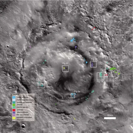
Five craters (Lyot; Micoud; and the unnamed craters c308, c375, and c194) were selected for mineralogy ana-lysis and mapping, based on initial reconnaissance to locate hydrous minerals (Pan et al., 2017) with CRISM data of all craters>1 km in the Lyot vicinity. The c### designation corresponds to the crater ID of unnamed craters in the Mars global crater database (Robbins & Hynek, 2012a).
3.2. Mineral Identification and Mapping Using CRISM Data
To identify and map the different hydrous minerals in the Lyot vicinity, we studied the full and half resolution targeted images (with resolution 18–36 m/pixel) from CRISM on board MRO. CRISM is a push-broom imaging spectrometer, which acquires visible/shortwave-infrared wavelength reflectance data over two detectors between 0.36 and 3.92μm with the highest spatial resolution of 15–19 m/pixel (Murchie et al., 2007). Data processing follows standard routines (e.g., Ehlmann et al., 2009; Murchie et al., 2009), including converting radiance to I/F data, photometric correction, and atmospheric correction based on the volcano scan method (Murchie et al., 2007). After converting to I/F data, we apply a denoising algorithm (method details in Pan et al., 2017). In brief, wefirst remove statistical outliers in the spectral domain. We then calculate column-specific “bland” spectra to use as denominators, by using the median of pixels in the same column that
10.1029/2017JE005461
lack absorptions in mineral parameter maps. By ratioing the original spectrum of each pixel to the spectrally bland spectra, we compute a ratioed image cube, which is then used for identifying mineralogy. We perform spectral parameter analysis where we highlight pixels with strengthened absorptions at specific wavelengths for easy identification of spectrally interesting regions, using customized spectral parameters (Table 1). We verify the denoising algorithm products by comparison to products based on standard parameter maps (Pelkey et al., 2007).
We analyzed 73 CRISM-targeted images covering the impact structures of thefive craters with previously identified mafic and/or hydrous minerals; 32 images covering the overland channels to the north of Lyot; and 93 images covering the ice-rich regions of Deuteronilus Mensae. Using the ratioed infrared spectral data, we identify different spectral classes, based on consistent band location and width and covarying depths. Different spectral classes identified in CRISM images are compared with the U.S. Geological Survey spectral library (Clark et al., 2007) and hydrous minerals are identified based on the spectral features. We also
Figure 1. The geologic context of the study region of Lyot crater and its vicinity near the dichotomy boundary: (a) Lyot cra-ter at 55°N, 30°E, and four cracra-ters (Micoud, c308, c375, and c194) in the vicinity of Lyot investigated in this study on Mars topography map from Mars Orbital Laser Altimeter, in Mars North Polar Stereographic Projection; (b) geological units mapping of the same region (Tanaka et al., 2014). Amazonian units are in green, and Hesperian units are in red and purple. Except for c194, which is situated in the Hesperian-Noachian transition unit, all the other craters investigated in this study are mapped as Amazonian-Hesperian impacts (AHi), overlying the late Hesperian terrains of the northern lowlands.
10.1029/2017JE005461
mapped the units with hydrous mineral detections based on CRISM spectral parameter maps in geographic information system software to better understand their distribution and correlation to morphology.
3.3. Other Data Sets
To further our understanding of the formation processes for the hydrous-mineral-bearing units in Lyot and its vicinity, we investigated data from the CTX (Malin et al., 2007) and High Resolution Imaging Science Experiment (HiRISE; McEwen, Eliason, et al., 2007) instruments onboard MRO and the THEMIS instrument onboard Mars Odyssey. We constructed a full coverage CTX mosaic over the Lyot crater using a nondestruc-tive blending technique (Dickson et al., 2018) with CTX grayscale images acquired over visible and near-infrared wavelengths, at a resolution of ~6 m/pixel and in swaths of ~30 km. The HiRISE instrument, which has a resolution ~30 cm/pixel, also acquired imagery covering parts of thefive impact craters. HiRISE acquires both grayscale and three-band color with the gray scale captured in ~6-km-wide swaths and the color acquired in ~1.2-km-wide swaths in the center of the grayscale image. We manually coregister higher-resolution CTX and HiRISE images with CRISM images where hydrous mineral detections are made to investigate the correlation of mineralogy with morphological units. Daytime and nighttime infrared image mosaics from THEMIS provided additional information on the thermophysical properties of relevant units (Edwards et al., 2011).
3.4. Crater Morphology and Excavation Depth Estimate
We extracted the geometric data for each of thesefive craters from the Mars Global Crater Database (Robbins & Hynek, 2012a; Table 2 and Figure 1) and calculated the maximum excavation depth for ejecta, approxi-mated to 1/10 of the diameter of the transient crater (Dexc= 1/10 Dtransient; Melosh, 1989). The diameter of the transient crater can be computed following the crater scaling relationship: Dtransient= a (Dfinal)b(D*)c, where D* is the transition crater diameter (~8 km for Mars; Garvin & Frawley, 1998); Dtransientis the diameter of the transient crater; Dfinalis the rim-to-rim diameter of thefinal crater; and a, b, and c are scaling depending on different scaling relationships (Croft, 1985; Holsapple, 1993; Melosh, 1989; see Table 3). We calculate the range of possible maximum excavation depths based on these scaling relationships for each crater. For deposits within crater central peaks, we also estimate the depth of origin of central peak materials based on an empirical relationship (SU = 0.086*D1.03; Grieve & Pilkington, 1996).
To assess the degradation state of the craters, we compare the estimated morphology parameters for pristine craters to crater morphology. We report a calculated crater depth (d) between the values predicted by scaling relationships d = 0.25D0.53(Whitehead et al., 2010) and d = 0.323D0.538(Tornabene et al., 2018), where D is the diameter of the crater. These relationships are chosen to cover the range of values predicted based on the scaling relationships in previous Martian craters catalogs (Garvin et al., 2003; Robbins & Hynek, 2012b; Stewart & Valiant, 2006). Expected crater rim height (h) is calculated from scaling relationships: h = 0.025D0.820(Robbins & Hynek, 2012b) and h = 0.02D0.84(Garvin et al., 2003).
4. Results
4.1. Geological Investigation of Lyot Crater
With the analysis of CRISM, CTX, and HiRISE data, we have identified at least five distinguishable spectral classes and mapped out associations with rocks and sediments within and around Lyot crater.
Table 1
Relevant Spectral Parameters in the Study
Spectral parameter Formulation
BD (1.9μm) 1–2*MED (R191:R194)/(MED (R173:R185) + MED (R210:R216))
BD (Mg-OH) 1–2*MED (R229:R233)/(MED (R208:R218))
BD (2.35μm) 1–2*MED (R234:R237)/(MED (R226:R231) + MED (R244:R248))
BD (Al-OH) 1–2*MED (R220:R225)/(MED (R213:R217) + MED (R225:R229))
BD (Olivine) 1.-AVG (R135,R140)/AVG (R170,R181)
BD (LCP) 1-AVG (R185,R215,R208)/AVG (R135 + R154 + R248 + R258)
Note. R### is the reflectance at a specific channel, for example, R190 stands for reflectance value at a wavelength of 1.9μm. MED is the median, and AVG is the mean of the following channels in parentheses.
10.1029/2017JE005461
4.1.1. Spectral Properties and Distribution of Hydrous Minerals
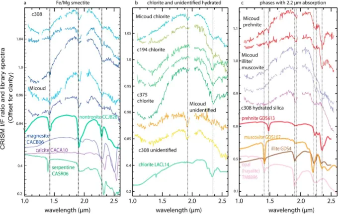
The spectral class with weak 2.3-μm absorptions coexisting with 1.9-μm absorptions is found mainly on the peak ring of Lyot (Figure 2a). The detections have a weak Fe-OH or Mg-OH absorption (~0.5% lower re flec-tance than continuum) in channels between 2.29 and 2.31μm and, typically, a coexisting weak 1.9-μm absorption related to H2O. The position of these absorption bands is consistent with Fe/Mg phyllosilicate detections (Bishop et al., 2002; Clark, 1999), likely smectite or mixed-layer smectite-chlorite. The correlation of these spectral properties with features of discrete surface morphology suggests that these spectra are associated with geologic units of distinct compositions. The Fe/Mg phyllosilicates are mostly concentrated in the kilometer-sized knobs in the peak ring of Lyot (Figures 3 and 4).
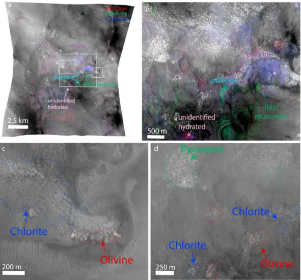
The spectral class with a strong (and broad) 2.35-μm absorption band is identified as chlorite (Figure 2b), con-sistent with the library spectra of chlorite with a strong Mg-OH absorption at 2.35-μm and a weak 1.9-μm H2O absorption (Bishop et al., 2008). In Lyot crater, chlorite detections often appear in spatial mixtures with other phases, including Fe/Mg phyllosilicate, illite/muscovite, or prehnite, which causes variations in band position and width. Chlorite detections are widely distributed in Lyot crater (Figure 3), mostly found associated with bedrock units in the peak ring and terraced rim of the crater. Chlorite is also the most common spectral class associated with Lyot’s proximal ejecta.
A distinct class of spectra is found with a 2.21-μm absorption coexisting with a 2.35-μm absorption (Figure 2), sometimes associated with 1.4- and 1.9-μm bands. This is identified as illite or muscovite, matching the spec-tral features of mica or high-charge phyllosilicates (e.g., vermiculite and mixed illite-smectite) with both sharp 2.21- and 2.35-μm absorptions (Clark et al., 1990). The width of the 2.21-μm feature is inconsistent with that of hydrated silica, which has a broader absorption (Anderson & Wickersheim, 1964; Milliken et al., 2008). In Lyot, illite/muscovite always occurs in close proximity to chlorite/prehnite features (Figure 3). Spatial mixing with nearby chlorite is a possible explanation of the strong 2.35-μm feature, often equivalent to or stronger than the 2.21-μm feature. Illite/muscovite has been identified previously in the southern highlands (Carter et al., 2013; Ehlmann et al., 2009; Fraeman et al., 2009) and often co-occurs with chlorite minerals (e.g., Ehlmann et al., 2009),
Table 2
Summary of Hydrous Mineral Detections in Lyot Crater and Smaller Complex Craters in the Vicinity of Lyot
Crater ID
Crater
name Crater age
Latitude (degree) Longitude (degree) Diameter (km) Rim to floor depth (km) MOLA elevation (km) Maximum excavation depth (km)
Hydrous mineral detectionsa Central peak/ring Crater wall/rim Ejecta Crater floor 05-000000 Lyot Early Amazonian 50.46 29.31 220.3 3.14 3.75 13–14 Fe/Mg sm, chl, hyd chl, ill/mus, preh Fe/Mg sm, chl, ill/mus, hyd chl, ill/mus 05-000053 Micoud Amazonian, probably younger than Lyot 50.56 16.35 50.3 1.55 4.04 3.2–3.8 Fe/Mg sm, chl, preh, ill/mus, hyd n.d. no coverage Fe/Mg sm, hyd 05-000308 Unnamed (c308) Amazonian, younger than Lyot 49.09 20.99 22.4 1.29 3.88 1.4–1.9 Fe/Mg sm, silica, hyd, no coverage n.d. n.d. 05-000375 Unnamed (c375) Amazonian, probably younger than Lyot 52.42 39.86 20.0 1.20 3.59 1.3–1.7 chl n.d. n.d. n.d. 05-000194 Unnamed (c194) Hesperian-Amazonian 47.91 53.78 28.4 0.52 3.05 1.8–2.3 - n.d. n.d. chl
Note. Crater ID and geometry data are from Mars global crater database (Robbins & Hynek, 2012a).
aMineral abbreviations: chl = chlorite; Fe/Mg = Fe/Mg smectite; ill/mus = illite/muscovite; n.d. = not detected; preh = prehnite; silica = hydrated silica;
hyd = hydrated unidentified.
Table 3
Scaling Parameters for Complex Crater’s Transient Crater Diameter Used
Parameters a b c
Melosh, 1989 0.65 1 0
Holsapple, 1993 0.758 0.921 0.079
Croft, 1985 1 0.85 0.15
10.1029/2017JE005461
but within the northern lowlands, it is only found to occur in the Lyot vicinity (Carter et al., 2013; Pan et al., 2017).
The spectra with distinctive 1.47- to 1.48-μm absorption coexisting with 2.23- to 2.24-μm and 2.35-μm absorptions (Figure 2) is a different class associated with the mineral prehnite. The existence of a 1.48-μm absorption and its weak 2.2-μm feature at longer wavelengths distinguish the prehnite from illite/muscovite. Prehnite is a Ca- and Al-rich inosilicate mineral that forms in hydrothermal or metamorphic environments on Earth. The occurrence of prehnite indicates an elevated temperature of at least ~200 °C and is a typical product in low-grade metamorphism (Robinson, 1987). Prehnite is not found within the crater or
Figure 2. CRISM spectra and associated library spectra of hydrous minerals identified in Lyot crater. (a) Fe/Mg phyllosilicate detections, likely smectite or mixed-layer smectite-chlorite. (b) Chlorite is detected with a strong 2.35-μm absorption band, in most cases lacking 1.9 μm. (c) Illite/muscovite is identified with a 2.21 μm coexisting with a 2.35-μm absorption. A spectrum of hydrated silica (opal) is shown for comparison of the 2.21-μm band. (d) Prehnite is identified by distinctive 1.47-to 1.48-μm absorption coexisting with 2.2- and 2.35-μm bands. (e) Unidentified hydrated minerals with only 1.9-μm absorptions and possible 2.5-μm bands. Here we show the library spectra of (hydrated) halite, anhydrite, and zeolite spectra with possible matching features. The lab spectra of saponite and nontronite are from CRISM spectral library, and all other lab spectra are from USGS spectral library (Clark et al., 2007). The CRISM image ID and coordinates of the central pixel the spectra are extracted from are given in Table A1. CRISM = Compact Reconnaissance Imaging Spectrometer for Mars; USGS = U.S. Geological Survey.
10.1029/2017JE005461
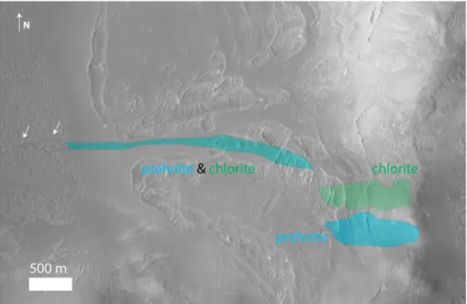
on the ejecta blanket, but only in three occurrences on the crater rim of Lyot (Figure 3). Prehnite detections in Lyot sometimes occur in close proximity to illite/muscovite and chlorite deposits.
The last spectral class with a distinctive 1.9-μm absorption lacks other diagnostic well-defined absorption bands in the 2.1- to 2.5-μm region (Figure 2e). This type of spectra could be explained by a zeolite with absorptions only at 1.9 and 2.5μm, a hydrated chloride or polyhydrated sulfates with drop-off at 2.4 μm. Alternatively, these could be other kinds of hydrated silicate minerals with enhanced water absorptions rela-tive to metal-OH absorptions due to change in relarela-tive humidity, while the absorptions in the 2.1- to 2.5-μm region are weak and cannot be distinguished from noise in the CRISM spectra. In Lyot crater the unidentified hydrated mineral occurs in the central peak as well as on the ejecta blanket (Figure 3).
4.1.2. Morphology of Hydrous Mineral Units
As the previous mapping in Lyot based on CTX data showed, several different surface morphologic units are present in Lyot crater (Dickson et al., 2009). Based on observations of the superposition relationships between the different units, the identified units from older to younger ages are (1) a bedrock unit with knobs and mesas in the peak ring, the terraced crater rim, and the craterfloor; (2) a stippled mantling unit that embays the knobs and mesas; (3) the sinuous channels and fans in thefluvial valley system; and (4) a smooth mantling unit that often occurs on sloping surfaces interpreted to be mass-wasting products from the uplifted bedrock. Previous work on the chronology indicates emplacement of the stippled mantling unit in the mid-late Amazonian after the Lyot impact, and then the channels and fans formed, cross-cutting or overlying the man-tling unit in the late Amazonian (Dickson et al., 2009).
In the peak ring, Fe/Mg smectite and chlorite detections are found spatially associated with topographic highs of the bedrock unit (Figures 4 and 5), though fresh bedrock is not apparent due to mantling. Near the crater rim, chlorite detections co-occur with illite/muscovite in eroded bedrock units (Figure 6), but they sometimes also occur in the smooth mantling units near these topographic highs (Figures 7b and 7c). The
Figure 3. Distribution of the detections of different spectral classes from CRISM data on a CTX mosaic of Lyot crater, with fluvial channels mapped inside the crater. Outlines of CRISM data show the coverage and images examined for mineral detections. CRISM = Compact Reconnaissance Imaging Spectrometer for Mars; CTX = Context Camera.
10.1029/2017JE005461
Figure 5. Fe/Mg smectite bearing units in Lyot crater peak ring. (a) CRISM image (FRT0000CB40) spectral parameter overlay, where red is olivine; green is unidentified hydrated mineral; blue is Fe/Mg smectite. (b and c) Digitized mineral detections on CTX image D02_027864_2294_XN_49N330W. CRISM = Compact Reconnaissance Imaging Spectrometer for Mars; CTX = Context Camera.
Figure 4. Lyot crater mineral map as in Figure 3 the locations of Figures 5–9 indicated. See Table A2 for a full list of the relevant image IDs and projections for the followingfigures.
10.1029/2017JE005461
orientation of the materials down the topographic gradient from the bedrock highs suggests that the detections are of mass-wasting products derived from the bedrock unit. Prehnite has the most distinctive distribution only found close to the crater rim (Figure 3) with two locations on the eastern part of the crater and one on the northwest crater rim location in mixture with illite/muscovite. One prehnite outcrop can be traced from the crater rim to within the crater, following topographic lows, with a morphology consistent with mass wasting of 3- to 4-km distance (Figures 6 and 8). The trace of prehnite-bearing sediments cannot be correlated with the surface morphology in the overlapping HiRISE image (Figure 8), but it is located immediately downslope of the prehnite detection on the rim and small channels incising the mantling unit follow the downslope direction of the mass-wasting deposit. The unidentified hydrated mineral found in the central peak image is correlated with a bedrock exposure with light-toned, fractured unit in the central peak (Figure 9).
Sinuous, kilometer-long channels have been mapped in Lyot cutting across the stippled mantling unit (Dickson et al., 2009). These channels form in topographic lows in between the high-standing bedrock (Figures 7a–7c), diverting around the bedrock knobs (Figure 3), incising the mantling unit. This relationship demonstrates that thefluvial activity forming sinuous channels started later than the emplacement of man-tling units, which embay the phyllosilicate/chlorite-bearing bedrock units. Thus, the sinuous channels did not contribute to the formation of these hydrous minerals but rather played a role in exposing them. Based on cross-cutting relationships, the channel-formation marks the latest aqueous event within Lyot crater.
4.1.3. Scouring Channels to the North of Lyot
Channelized scablands are found to the north of Lyot outside the ejecta blanket (Harrison et al., 2010) with only a few small, morphologically distinct channels recently identified on the ejecta (Weiss et al., 2017).
Figure 6. Chlorite and illite/muscovite detections in the lower levels of the terraced crater wall of Lyot. The detections correlate with degraded knobs embayed by stippled mantling unit. The prehnite detection is located near the crater rim on the smooth mantling units, comprised of materials that have been transported downslope. Spectral parameter map of CRISM image (FRT00020B25) is shown with the color composite of R: BD (1.9μm) G: BD (Mg-OH) B: BD (2.35 μm). Background is CTX image D19_034602_2296_XN_49N328W in simple cylindrical projection). CRISM = Compact Reconnaissance Imaging Spectrometer for Mars; CTX = Context Camera.
10.1029/2017JE005461
Thirty-two CRISM-targeted images were examined (see Table A3) north of Lyot crater covering the region wherefluvial channels have been previously identified, and we did not identify any hydrous minerals.
4.2. Mineralogy of Complex Craters in Lyot’s Vicinity 4.2.1. Micoud Crater
Micoud crater (D = 50 km) is a complex crater with a terraced rim situated to the west of Lyot. Micoud has been partiallyfilled by a mantling unit that has been later eroded, evidenced by a buried small crater near the central peak. Micoud crater’s impact ejecta were emplaced atop the late Hesperian plains material, same as Lyot crater (Figure 1). The interior of Micoud is covered by a mantling unit that has been eroded. The stra-tigraphic relationship with other northern plains units,fill, and overall degradation state is similar to Lyot cra-ter. The secondary craterfield of Lyot (Robbins & Hynek, 2011) extends to the west of Micoud but becomes less prominent within and near Micoud crater, which suggests a similar but possibly younger formation age than Lyot, in the Amazonian.
Micoud crater has the same set of diverse hydrous minerals as Lyot, including Fe/Mg smectite (with possible carbonate detection, in this case), chlorite, illite/muscovite, prehnite, and an unidentified hydrated mineral
Figure 7. Representative sinuous channels that transect knobby regions in Lyot crater with hydrous mineral detections. White arrows indicate the sinuous channels in each image. Channels are diverted around landforms with hydrous mineral detections: (a) chlorite and illite/muscovite, (b) chlorite and Fe/Mg phyllosilicate, and (c) illite/muscovite. The background image is a CTX mosaic in Mars North Polar Stereographic Projection, and the outline of hydrous mineral detections are mapped out based on CRISM detections (FRT00029B25, FRT00023F1F, and FRT00021FCB). CRISM = Compact Reconnaissance Imaging Spectrometer for Mars; CTX = Context Camera.
10.1029/2017JE005461
(Figure 10). Except for one craterfloor deposit, most hydrous minerals are concentrated in the degraded central peak of Micoud, in discrete units (Figure 11a).
Two different spectral classes with 2.3-μm absorptions are found in Micoud (Figure 10a). One is found close to the central peak, with a sharper and narrower 2.3μm and a possible 2.5 μm band, in addition to 1.4- and 1.9-μ m bands due to H2O and OH. The presence of 2.5-μm absorption agrees with magnesium carbonate spectra, which have C─O overtones at ~2.31 and ~2.51 μm (Gaffey, 1987), but the width of the 2.3-μm band is narrow, which matches better with nontronite than magnesite, though the 2.4-μm band often present in nontronite is not observed. There is no clear correlation of the band depths of the 2.3- and 2.5-μm bands, since the detections are limited to small regions. A second spectral class has much broader, asymmetric 2.3- and 2.5-μm absorptions, which may be explained as carbonate or Fe/Mg smectite mixing with phases with a longer 2.35-μm feature such as chlorite or Fe-serpentines. This type of spectra is found mantling the complex zone of bedrock displaced as lower wall terraces and fallback breccia. Regardless of the phase(s) responsible, the 2.3-μm absorptions in these Micoud spectra are stronger and broader than what we see in Lyot. The hydrous mineral present in Micoud with 2.3- and 2.5-μm absorptions is mapped as Fe/Mg smectite, though coexis-tence of intermixed carbonate is possible.
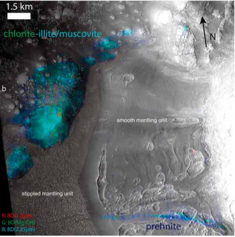
Chlorite is also detected in Micoud’s central peak (Figures 11 and 12). The 2.35-μm absorption is broad and associated with a weak 1.9-μm absorption. Sometimes, the chlorite spectra exhibit a 2.5-μm absorption, similar to the second type of Fe/Mg smectite described above (Figure 10b). These chlorite detections are likely in mixture with Fe/Mg smectites. Illite/muscovite and prehnite detections occur in the same general region within the central peak (Figure 12). Several pixels close to the illite/muscovite have a 1.48-μm absorption band that matches prehnite (Figures 10c and 12). These spectra are similar to the spectra of illite/muscovite and prehnite in Lyot and are found adjacent to mafic-mineral-bearing light-toned bedrock (Figures 12c and 12d). Occurring on the side slope of bedrock, it is unclear if chlorite detections are associated with a mantling material or with the bedrock that is different in composition. An unidentified type of hydrated mineral is also found in a small portion of the light-toned fractured material in Micoud central peak (Figure 10b), near more widespread chlorite detections and localized prehnite and illite/muscovite detections adjacent to the region of mafic-mineral-bearing rocky units.
Figure 8. Detailed morphology of the prehnite and chlorite bearing units on the crater rim and the linear feature with prehnite and chlorite spectral signature near the crater rim seen in Figure 6. The regions of hydrous minerals are highlighted and outlined based on CRISM images (FRS0002CB59 and FRT00020B25) coregistered to CTX image (D19_034602_2296_XN_49N328W). The elongated shape of the prehnite and chlorite detections on the slope next to the crater rim indicates mass wasting of the mineral-bearing materials. White arrows show the small channels in the stippled mantling unit, just downslope of the mass-wasting deposit. CRISM = Compact Reconnaissance Imaging Spectrometer for Mars; CTX = Context Camera.
10.1029/2017JE005461
4.2.2. Crater c308
c308 is a complex crater (diameter, 22 km) ~240 km west of Lyot crater rim. Its crater ejecta overlies the eroded margin of the distal ejecta blanket of Lyot, and the ejecta blanket is well preserved with no sign of disruption by Lyot crater. Thus, c308 likely formed after Lyot. Two kinds of spectra with a strong 2.3-μm band coexisting with 1.9- and 1.4-μm bands have been identified and classified as Fe/Mg smectite (Figure 10a). Similar to Micoud, these spectra with 2.3-μm bands are accompanied by possible 2.5-μm absorptions, with varying relative depths and widths. The varying band width and depth may be induced by varying degrees of mixing with a carbonate endmember that has wider 2.3-μm band than Fe/Mg smectite. In c308, we also detect the presence of hydrated silica, with a broad band at 2.2μm as well as an additional 1.9-μm band (Figure 10c). An unidentified hydrated mineral is also present (Figure 10b). These hydrous mineralogies are concentrated in the central peak region (Figure 13), sometimes associated with exposed bedrock and mass-wasting products near those exposures, with distinct surface texture from that of the light-toned mafic-mineral-bearing block (Figures 13f and 13g).
4.2.3. Crater c375
c375 is a 20-km-diameter crater on the distal ejecta blanket of Lyot, which also postdates the Lyot impact. It has been previously studied as unnamed Ismenius Lacus impact crater (Turner et al., 2016). The crater is par-tiallyfilled with later mantling units and has a central mound ~4.2 km in diameter, ~500 m in height in the center of the crater (Figure 13). This mound is smooth and the blocky central peak materials are mantled by sedimentary debris, with channels incising mantling materials. Unlike Lyot, Micoud, and c308, chlorite is the only hydrous mineral detected here in the central mound (Figure 10b), confirming the detection made by Turner et al. (2016). Active gully formation creates new fan deposits in the central mound, and the chlorite detections are found on dust-free surfaces in the central mound as well as in thefine-grained sediments at the base of the mound (Figures 11c and 14). In addition, there is a prominent linear, light-toned feature
Figure 9. Lyot crater central peak region with a detection of an unidentified hydrated mineral on the bedrock unit. Mineral mapping is based on CRISM image (FRT0000B133). The background image is HiRISE image ESP_027376_2310 in simple cylindrical projection. CRISM = Compact Reconnaissance Imaging Spectrometer for Mars; HiRISE = High Resolution Imaging Science Experiment.
10.1029/2017JE005461
~1 km in length and up to 200 m in width within the eastern slope, which is spatially correlated with the chlorite detection (Figures 14b and 14d). The linear, light-toned feature has a sharp, abrupt boundary at the interface with the surrounding materials.
4.2.4. Crater c194
c194, with a crater diameter of 28 km, is within the Hesperian-Noachian unit. The crater rim elevation varies from 2,750 m (relative to MOLA datum) on the northwest side to 2,350 m on the southeast side, but the craterfill is relatively homogeneous in elevation with the minimum at around 3,100 m. The crater depth varies between ~350 and ~750 m, which is much shallower than the expected crater depth (~1.46 to ~1.94 km) pre-dicted for pristine Martian craters (see section 3). Both the shallow depth and the absence of a central peak indi-cate that the crater is heavily degraded by erosion and infill. These infilled sediments form a concentric ridged surface inside the crater (Figure 11d), consistent with typical concentric craterfill widespread in the region (Levy et al., 2010). This infill unit has been proposed to form via successive episodes of sublimation of near-surface ice. Only dark patches of the infill unit have the concave continuum and strong 2.35-μm band typical of chlorite (Figures 10b and 11d). The dark region is located in the northeast part of the crater in a local topographic low at the transition between the steep crater wall with ~300-m relief and theflat crater floor with infilled sedi-ments (Figure 15). Though dark in the visible-near-infrared (HiRISE and CTX), the area is brighter in the THEMIS nighttime infrared image compared to surrounding units, indicating a higher nighttime temperature and thus higher thermal inertia compared to the surrounding surface. The presence of the decameter-scale ridges or terraces (Figure 15) and the higher thermal inertia of the chlorite-bearing deposits are consistent with higher degree of induration of the underlying craterfill compared to the surrounding units.
Figure 10. CRISM ratioed I/F spectra of hydrous minerals identified in smaller complex craters around Lyot compared to lab spectra (Clark et al., 2007). (a) Fe/Mg phyllosilicate detections in Micoud and c308. (b) Chlorite detections in Micoud, c194 and c375 with a strong 2.35-μm absorption and unidentified hydrated detection in Micoud and c308. The chlorite detections in c194 and c375 lack 1.9-μm band as typical chlorite, but the detection in Micoud has the additional 1.9-μm feature. (c) Less frequently appearing phases with 2.2-μm absorptions are shown in this panel. Prehnite detection is found with a 1.48-μm band in two outcrops in the central peak of Micoud crater; illite/muscovite is identified with a 2.21 μm coexisting with a 2.35-μm absorption, with a weak 1.41-μm band. In c308, we detect the presence of hydrated silica with a broad band at 2.2μm as well as additional 1.4-μm band, distinct in spectral properties from the other detections.
Wavelength regions with known CRISM artifacts and residual of atmospheric correction are masked. Lab spectra are from USGS spectral library (Clark et al., 2007). The CRISM image ID and coordinates of the central pixel the spectra are extracted from are given in Table A1. CRISM = Compact Reconnaissance Imaging
Spectrometer for Mars; USGS = U.S. Geological Survey.
10.1029/2017JE005461
4.3. Subsurface Ice Deposit and Hydrous Minerals in Deuteronilus Mensae
We surveyed thoroughly the CRISM images in the regions with subsurface ice deposits to better understand their relationship to hydrous mineral formation (Figure 16 and Table A4). We found an illite/muscovite detection ~250 km to the south of Lyot crater rim, around the same elevation as the Lyot preimpact surface ( 3,510 m rela-tive to MOLA). Fe/Mg phyllosilicate is found in small knobs and on the wall of channels and mesas further south (300–400 km from the Lyot crater center) located at a higher elevation ( 2,000 to 3,000 m relative to MOLA), as well as in a steep-walled impact crater at the southwesternmost extent of the study area occurring with hydrated silica detections on the craterfloor. The above hydrous detections occur on small knobs or slopes of mesas (e.g., Figure 17), while the lobate debris aprons with subsurface ice detections in the study region have dusty surfaces and do not show different spectral properties from the surrounding units.
5. Discussion
5.1. Relationship of Hydrous Mineralogy to Fluvial Geomorphology
In search for associated mineralogical traces offluvial activities, we find no hydrous mineral detections asso-ciated to thefluvial channels north of Lyot extending from its ejecta blanket, which are a sign of postimpact, and likely impact-induced,fluvial activity (Harrison et al., 2010; Weiss et al., 2017), in contrast to the diverse
Figure 11. Distribution of hydrous minerals in craters in the vicinity of Lyot: (a) Micoud, (b) c308, (c) c375, and (d) c194. Multiple hydrous minerals have been found in Micoud and c308, distributed in the central peak region, but only chlorite has been identified in c375 and c194, associated with distinct morphologic features, respectively.
10.1029/2017JE005461
hydrous mineralogy found within Lyot crater and other smaller craters. Although dust cover may mask some potential mineral detections, wefind it unlikely that dust cover is the sole reason for the lack of detection of hydrous minerals, in particular with various exposures of smaller complex craters and scarps in this region and the relatively light dust cover compared to Deuteronilus Mensae (Ruff & Christensen, 2001), where hydrous minerals have been identified. Thus, we interpret that the channel formation events did not generate pervasive alteration and that the formation of the hydrous minerals inside craters is likely a distinct event from the channel formation to the north of Lyot. The lack of mineralization associated with these channels implies a rapid and probably low-temperature formation process, consistent with the melting of surface ice/snow from hot ejecta or dewatering of an ejecta blanket (Harrison et al., 2010; Weiss et al., 2017), instead of impact-induced groundwater circulation. Indeed, Weiss et al. (2017) estimate that only 102to 103years of erosion from melt of surface or near-surface ice beneath the ejecta are required to carve the channels. For acid weathering in Mars relevant conditions, kinetic and thermodynamic models predict some secondary minerals (e.g., amorphous silica) start to form for a duration of 102to 103years, but the volume is below 1% (Zolotov & Mironenko, 2007), which would be too low to detect from orbit. Given the uncertainties of initial pH, pressure, grain size, water to rock ratio, and degree of exposure, the duration required for secondary alteration may vary up to several orders of magnitude (e.g., Velde &
Figure 12. CRISM detections of hydrous minerals in the central peak region of Micoud crater. (a) Colored CRISM spectral parameter map (from image FRT00019658) overlay. The different colors represent different hydrous mineralogy as indi-cated on thefigure (purple: chlorite; green: illite/muscovite; greenish blue: Prehnite; red: hydrated unidentified). (b) Zoom-in of CRISM parameters for hydrous mZoom-ineralogy overlaZoom-in on HiRISE (PSP_009997_2310) data. (c and d) MZoom-ineral detections digitized based on spectral parameter maps from CRISM image (HRL0000C75D) overlain on HiRISE (PSP_009997_2310), showing the spatial relationship of mafic and hydrous mineral detections. CRISM = Compact Reconnaissance Imaging Spectrometer for Mars; HiRISE = High Resolution Imaging Science Experiment.
10.1029/2017JE005461
Meunier, 2008; Zolotov & Mironenko, 2007), but it is possible that the time span of liquid water that formed these channels may be too short for extensive mineralization that is sufficient to be detectable from orbit. Within Lyot, no hydrous minerals are found in association with the stippled mantling unit, but some of the smooth mantling units in Lyot have chlorite or illite/muscovite features, which usually occur next to
Figure 13. Geologic context of hydrous minerals in crater c308. (a) MOLA elevation overlain on THEMIS daytime infrared data on crater c308 in Mars North Polar Stereographic Projection, showing the context for CRISM image FRT00017D51. (b) CRISM color overlay with spectral parameter maps, with spectral signature associated the dark regions in the central peak. (c–e) Zoom-in on particular locations with CRISM detection on HiRISE image ESP_025082_2295. (f and g) Zoom-in showing the different textures of mafic-bearing and smectite-bearing units in (e). CRISM = Compact Reconnaissance Imaging Spectrometer for Mars; HiRISE = High Resolution Imaging Science Experiment; MOLA = Mars Orbiter Laser Altimeter; THEMIS = Thermal Emission Imaging System.
10.1029/2017JE005461
bedrock units with the same mineralogy. This implies that the hydrous minerals in the mantling units may be sourced locally from the adjacent bedrock units. In addition, sinuous channels on the crater wall are observed to be incising and thus postdating the mantling units and are diverted by the hydrous-mineral-bearing knobs and mesas (Figure 7). Therefore, sinuous channels and fans represent a separate stage of aqueous activity in Lyot crater, which postdates the mantling units and the hydrous mineral forming units. Again, this episode of water activity appears unrelated to the formation of the hydrous mineral units detected from orbit within Lyot.
5.2. Formation of Hydrous Minerals in Lyot
Since thefluvial features are not responsible for the hydrous mineral formation, we consider two different mechanisms for the formation of these hydrous minerals within Lyot: (a) a syn-impact alteration scenario where hydrous mineral within Lyot crater formed during an impact induced hydrothermal system and (b) a preimpact formation scenario where hydrous minerals form in the subsurface and are then excavated by
Figure 14. The central mound of crater c375 where chlorite was detected. (a) Spectral parameter map from CRISM image (FRT0000BFA6) covering crater c375. (b) HiRISE image (ESP_044149_2325) of the central mound overlain by color com-posite in a), showing the context for insert c and d. (c) Active gully and fan forming on the northernflank of the mound. From HiRISE color image, the fan has a bluish hue compared to the other parts of the mound, indicating fresh, dust-free surface. (d) A linear, light-toned feature in the mound ~1 km in length. Insert showing the light-toned feature across the bedrock exposures on the central mound. CRISM = Compact Reconnaissance Imaging Spectrometer for Mars; HiRISE = High Resolution Imaging Science Experiment.
10.1029/2017JE005461
the impact. We focus, in particular, on the consequences of differential erosion of Lyot crater, the spatial distribution of hydrous minerals, and scenarios for the origin of prehnite to better constrain the formation conditions of hydrous minerals in both models.
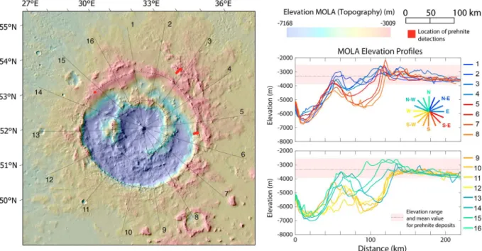
5.2.1. The Differential Erosion of Lyot Crater
One confounding factor to interpreting the spatial distribution and geological context of hydrous minerals is the possibility of modification by later erosion and degradation. The crater shows asymmetric morphology between the southwest and the northeast sides (Figure 18). The raised rim of Lyot crater consists of a series of degraded knobs at varying elevations but is absent on the southwest side. The impact ring in the south-west is much lower in elevation than in the northeastern part of the crater. In addition, Lyot lacks an ejecta blanket and proximal secondary craters to the southwest, which could be due to the denudation of the southwestern rim, an oblique impact, or both (Robbins & Hynek, 2011; Russell & Head, 2002). The differential erosion may explain why less hydrous mineral detections are in the southwest part of the crater, while the northern and eastern rims of Lyot, where most hydrous minerals are found, are relatively well preserved. The raised rim height for crater with a diameter of Lyot’s is predicted to be 1.8–2.1 km relative to the preimpact surface (see section 3). Since there is large variation in the elevation of preimpact surface ( 3.5 to 4.2 km) due to the northward downward trending slope of preimpact topography, we estimate the crater rim height by tak-ing the MOLA elevation at the rim subtracted by the elevation immediately outside the continuous ejecta blan-ket in the same direction. Although heavily degraded, wefind that the raised rim of Lyot can reach as high as ~1.7 km above the preimpact surface. Wefind that the height of Lyot’s raised rim is close to the expected range. Prehnite deposits are mostly found at elevation above the preimpact surface, except when they occur in mass-wasting deposits (Figure 18). This suggests that the prehnite-bearing deposits are part of
Figure 15. Context of the chlorite deposit in crater c194. (a) THEMIS daytime infrared image of crater c194 in Mars Polar Stereographic Projection; (b) THEMIS nighttime infrared image of the crater c194 in Mars North Polar Stereographic Projection, as a proxy for thermal inertia; (c) HiRISE image (PSP_009666_2280) of the ridged craterfloor units of crater c194 showing the bluer-toned, relatively dust-free materials in HiRISE color with a zoomed-in window showing the ridgedfloor unit with chlorite detections. HiRISE = High Resolution Imaging Science Experiment; THEMIS = Thermal Emission Imaging System.
10.1029/2017JE005461
the raised crater rim exposed after several hundred meters of erosion. Within the crater, the central peak and peak ring are the relatively low-lying topography, which is partially buried by the mantling unit.
5.2.2. Distribution of Hydrous Minerals in Lyot and Craters Nearby
The widespread hydrous mineralogy within Lyot crater shows at leastfive different spectral classes, which have been identified as follows: Fe/Mg smectite, chlorite, illite/muscovite, prehnite, and another hydrated mineral of unidentified type (see section 4.1). They mostly occur on or near the bedrock units in the central peak, peak ring, and terraced rim, even though the correlation to the morphology can be obscured due to mass wasting and denudation. The association with the bedrock units indicates formation directly related to the impact process, instead of transport, secondary sedimentation, or later weathering/alteration. The cen-tral peak of Lyot and the inner edge of crater peak ring are found with only unidentified hydrated detection and weak detections of Fe/Mg smectite, whereas prehnite, indicative of elevated temperature (>200 °C), is only found on the crater rim. Hydrous phases including chlorite and illite/muscovite are distributed between the peak ring and outer rim. We consider that impact melts may be preserved in Lyot crater and could give rise to some of the alteration signatures observed. However, due to the widespread mantling units of prob-ably glacial origin (Dickson et al., 2009), this Amazonian-aged crater is more degraded than craters at lower latitudes, and impact melt deposits are not identified.
Figure 16. (a) Geological context map of Deuteronilus Mensae region, with MOLA color hillshade map in Mars North Polar Stereographic Projection. (b) SHARAD detection of subsurface ice (white stripes in the zoom image, personal correspon-dence from J. Plaut) in Deuteronilus Mensae south of Lyot with THEMIS day IR mosaic in the background. Also shown here are the CRISM footprints in this region and associated hydrous mineral detections. In relatively dust-free regions, small outcrops of Fe/Mg phyllosilicate, illite/muscovite, and unidentified hydrated minerals have been identified.
CRISM = Compact Reconnaissance Imaging Spectrometer for Mars; MOLA = Mars Orbiter Laser Altimeter; SHARAD = SHAllow RADar; THEMIS = Thermal Emission Imaging System.
10.1029/2017JE005461
The two craters to the west of Lyot (c308 and Micoud) show mineral assemblages similar to Lyot, while the other two craters (c308 and c394) have only chlorite associated with craterfill. The distribution and mineral assemblages found in Lyot, Micoud, and c308 are consistent with either excavation of the same preimpact altered stratigraphy or impact-induced hydrothermal alteration in similar geologic conditions. The existence of unaltered uplifted bedrock of mafic compositions (e.g., Figures 5, 12, and 13) in proximity with hydrous units can be explained by either excavation and mixing during the impact process or that any impact-induced alteration is limited to localized vents or cracks for aqueous solutions. The craters to the east of Lyot (c194 and c375) likely underwent a separate event where chlorite is either transported or formed in situ while the sediments formed within crater, which is spatially restricted to the east of Lyot crater.
5.2.3. Origin of Prehnite in Lyot and Micoud
Prehnite formation requires a temperature of 200–350 °C at low pressure (<3 kbar) and very low mole frac-tion of CO2(XCO2<< 0.1; Robinson et al., 1999; Schiffman & Day, 1999), typically in association with chlorite and pumpellyite. In this study, wefind a prehnite deposit on the east, northeast, and northwest side of the Lyot crater as well as in small patchy deposits in the central peak Micoud crater.
Wefirst consider if the mineralogy and distribution of hydrous minerals in Lyot crater and its surroundings are consistent with the excavation of a hydrous-mineral-bearing subsurface stratigraphy. The various hydrous miner-als could have formed in a subsurface stratigraphy if they have been buried since Noachian when the geothermal gradient was high enough for burial diagenesis. In the absence of a local heat source, typical hypothesized Noachian geotherms require at least 1.0–2.5 km of depth to reach the minimum temperature of typical chlorite/illite formation temperature (Borlina et al., 2015) and a minimum depth of ~5.5 km for prehnite formation.
Figure 17. Exposure of phyllosilicate-bearing strata in Deuteronilus Mensae region. (a) CRISM image (FRT000049FF) of a southward facing scarp exposing Fe/Mg phyllosilicate. (b) Sample spectra from the highlighted region in (a) showing absorption bands at 1.9- and 2.3-μm region. (c and d) HiRISE image (PSP_002890_2205) of the outcrop, showing the bedrock on the scarp exposed due to active erosion.
10.1029/2017JE005461
Although the maximum excavation depth of Lyot crater can reach 13–14 km, the collapsed crater rim is expected to originate from relatively shallow depths, as observed in similar-sized Chicxulub crater where the col-lapsed rim materials consist of sedimentary units originate from shallower than ~3 km depth (J. V. Morgan et al., 2016). The estimated structural uplift for Micoud crater central peak can reach ~4.9 km (Grieve & Pilkington, 1996). Based on these estimates, the original depth of prehnite should be less than 5 km deep, insufficient for the minimum depth required for prehnite formation. However, mixing of different lithologies occurs during the central peak formation (Kenkmann et al., 2014) and the development of reverse and normal faults on com-plex crater’s terrace rim may induce kilometer-scale offsets of the original stratigraphy (Gulick, 2008), all inducing uncertainties to the original depth estimates. Thus, the formation of prehnite at depth cannot be completely ruled out but requires a higher geothermal gradient in the Noachian as proposed by Borlina et al. (2015). Otherwise, the relatively shallow original depth of prehnite would necessitate a locally elevated geothermal gra-dient or additional heat source preimpact for the formation of prehnite. Ancient impact or volcanic activity that mobilized subsurface water are both plausible scenarios for the formation of relatively shallow prehnite deposits. In a syn-impact alteration scenario, both Lyot and Micoud craters are large enough to mobilize the subsurface cryo-sphere and sustain a hydrothermal system, though the heat source of the impact is predicted to be most intense at the center region when freezing is considered (Barnhart et al., 2010). In the central peak of Micoud crater, central peak temperatures are predicted to reach above 350 °C and thus may reach prehnite formation temperature post-impact (Abramov & Kring, 2005; Schwenzer et al., 2012). For Lyot crater, the craterfloor and crater center do not have hydrous mineralogy indicative of elevated temperature, while the crater rim preserves such phases. The absence of prehnite in the central peak of Lyot may be due to the heterogeneity of the alteration or overprinting by cooler temperature alteration associated with the impact. The diagnostic petrologic textures that would pre-serve the evidence that impact heating facilitated the alteration or that the alteration predated the impact can only be seen at submeter scale. Future missions with the capability of resolving the microscale texture of the mineralogy may shed new light on the existence/absence of impact-induced hydrothermal systems on Mars.
5.3. Implications on Martian Climate in the Amazonian
As we have discussed, the observations of distribution of hydrous minerals within Lyot crater and its sur-roundings can be explained by impact excavation, syn-impact-induced alteration, or a combination of the two. Here we further discuss the implications for Martian climate based on these two endmembers.
Figure 18. Topography map and cross sections of Lyot crater. Crater peak ring is lower in elevation and crater rim is more heavily degraded on the southwestern side (yellow-orange profiles). Black dashed lines highlight the locations of crater rim and crater ring. On the elevation profiles, pink shaded regions are the range of elevations of prehnite found in this study.
10.1029/2017JE005461
5.3.1. Excavation and Subsurface Origin of Lyot Minerals
The identification of diverse hydrous minerals associated with Lyot and its surroundings can be interpreted as the excavation of previous hydrous-mineral-bearing strata in the subsurface. In this scenario, the origin of these hydrous minerals is constrained to be early (Noachian-Hesperian). The formation of prehnite in rela-tively shallow depths involves an elevated heatflow near surface, either due to a locally elevated geothermal gradient or impact or volcanic activity preimpact. The hydrous mineral-bearing stratigraphy is later exposed by erosion and the energetic impact in the Early Amazonian, unrelated to the channel forming events either north of Lyot ejecta, or the small sinuous channels within Lyot crater.
5.3.2. Impact-Induced Hydrothermal Alteration
Alternatively, the impact could have mobilized liquid water to induce alteration during or immediately after the impact. In such a scenario, hydrous minerals may form via water/rock interactions during groundwater circulation, within impact melt vents, or from crystallization in impact melt glass (Tornabene et al., 2013). The impact-induced activity of the groundwater circulation in Lyot may have created localized environments with liquid waterflow and enhanced alteration and could imply a cryosphere in the Lyot vicinity since the Early Amazonian. Nonetheless, the presence of prehnite detection on Lyot rim and the Micoud central peak and lack of detections in Lyot crater central peak suggest the secondary alteration in such a system is highly heterogeneous. The mafic blocks associated with hydrous minerals also indicate that the alteration is only restricted to regions where water may interact with bedrock locally, possibly through vents or fractures.
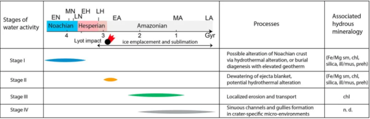
5.4. Synthesis of the Timeline of Aqueous Activity in Lyot Vicinity and Implications for Water on Amazonian Mars
From the investigation of mineralogy inside and surrounding Lyot crater, we suggest that the diverse hydrous minerals represent separate events of aqueous activity, predating geomorphicfluvial features found previously. Here we synthesize four possible stages of aqueous activity in the vicinity of Lyot constrained by the results of this study (Figure 19).
It is possible that some of the hydrous minerals, including Fe/Mg smectite, chlorite, and illite/muscovite, formed in the Noachian or Hesperian period via groundwater alteration, sometimes at hydrothermal/metamorphic temperatures, enabling the formation of prehnite. This may require elevated geotherm, the energy from previous impacts, or volcanic activity interacting with a local cryosphere or hydro-logic cycle. As Lyot crater forms in the Early Amazonian, it either exposed the preimpact stratigraphy with diverse hydrous minerals or formed new aqueous alteration deposits from hydrothermal activity induced by the impact. Channeled scablands were created to the north of Lyot probably from dewatering of ejecta blanket or melting of the surface ice/snow (Harrison et al., 2010; Weiss et al., 2017). This channel-forming event was likely relatively short-lived and took place at low temperatures since it did not result in the forma-tion of pervasive hydrous minerals.
Figure 19. Timeline of different stages of aqueous activity in the Lyot vicinity, with possibly related hydrous mineralogy. Mars epoch boundaries are from the chronology by Hartmann and Neukum (2001). EN = Early Noachian; MN = Middle Noachian; LN = Late Noachian; EH = Early Hesperian; LH = Late Hesperian; EA = Early Amazonian; MA = Middle Amazonian; LA = Late Amazonian. Mineral abbreviations: chl = chlorite; Fe/Mg = Fe/Mg smectite; ill/mus = illite/muscovite; n.d. = not detected; preh = prehnite; silica = hydrated silica. Parentheses indicate minerals that are possibly related to a certain stage of water activity.
10.1029/2017JE005461
Other small complex craters also formed nearby, some atop the Lyot ejecta blanket, excavating materials beneath. In the mid-late Amazonian, ice-related processes generate linear valleyfills, lobate apron units, and mantling units, which were emplaced in the general region of Deuteronilus Mensae, extending to par-tiallyfill the craters in the vicinity of Lyot. Probably during this period, chlorite-bearing mantling materials are deposited within craters to the east of Lyot. These deposits are either comprised of transported materials or mineralized in situ by liquid water, for example, during burial diagenesis.
After the emplacement of the stippled mantling units in the Amazonian, localized channels formed in Lyot crater that cut across the stippled mantling units and are diverted by the preexisting topography with hydrous-mineral-bearing units. The lack of hydrous minerals associated thefluvial channels inside Lyot crater, which postdate the mantling units, indicates that during the period of formation of these geomorphic fea-tures related to liquid water activity, the surface waterflow was transient in nature and/or mineral formation from water-rock interaction was kinetically inhibited, probably due to the low temperature of Mars surface.
6. Conclusions
The investigation into the mineralogical record of aqueous processes in Lyot and its surroundings revealed that smectite, chlorite, and illite/muscovite detections mostly occur within the crater peak ring and terraced crater rim, while prehnite units, indicative of formation temperature>200 °C, are found on the crater rim of
Table A1
Location of Spectral Detections in CRISM Data for Lyot and Small Craters
Figure # Crater/region Interpreted mineralogy CRISM image ID Center pixel/pixels Number of pixels
2a Lyot Fe/Mg smectite FRT0000CB40 X: 579 Y: 187 5 × 5
FRT0000CB40 X: 41 Y: 341 5 × 5 FRT0000CB40 X: 578 Y: 188 5 × 5 2b Chlorite FRT00020CC8 X: 588 Y: 99 7 × 7 FRT00020CC8 X: 600 Y: 126 7 × 7 FRT00018613 X: 366 Y: 277 5 × 5 FRT0001721B X: 594 Y: 63 6 × 6 2c Illite/muscovite FRS0003AEA3 X: 245 Y: 76 5 × 5 FRT00020B25 X: 358 Y: 461 5 × 5 FRT00020CC8 X: 247 Y: 218 7 × 7 FRT00020CC8 X: 160 Y: 225 7 × 7 2d Prehnite FRS0002CB59 X: 382 Y: 116 5 × 5 FRS000327E7 X: 373 Y: 148 5 × 5
2e Unidentified FRT0000CB40 X: 61 Y: 379 ROIs, 499
FRT0000B133 X: 290 Y: 317 ROIs, 177
10a c308 Fe/Mg smectite FRT00017D51 X: 262 Y: 160 ROIs, 346
FRT00017D51 X: 235 Y: 175, X: 238 Y:163 ROIs, 300
FRT00017D51 X: 198 Y: 60 ROIs, 302
Micoud Fe/Mg smectite FRT00016609 X: 543 Y: 61 5 × 5
FRT00009C3C X: 560 Y: 352 7 × 7 10b Micoud Chlorite HRL0000C75D X: 69 Y: 155 3 × 3 HRL0000C75D X: 142 Y: 309 3 × 3 c194 Chlorite FRT0000C141 X:240 Y: 313 5 × 5 FRT0000C141 X: 233 Y: 321 5 × 5 c375 Chlorite FRT0000BFA6 X: 326 Y: 182 4 × 4
Micoud Unidentified FRT00016609 X: 492 Y: 174 5 × 5
c308 Unidentified FRT00017D51 X: 204 Y: 234 7 × 7
10c Micoud Prehnite HRL0000C75D X: 147 Y: 279 3 × 3
HRL0000C75D X: 136 Y: 283 3 × 3
Micoud Illite/muscovite HRL0000C75D X: 231 Y: 207 5 × 5
HRL0000C75D X: 202 Y: 238 5 × 5
c308 Hydrated silica FRT00017D51 X: 325 Y: 191 ROIs, 302
17b Deuteronilus Mensae Fe/Mg phyllosilicate FRT000049FF X: 410 Y: 262 7 × 7
FRT000049FF X: 419 Y: 265 7 × 7
FRT000049FF X: 427 Y: 267 7 × 7
FRT000049FF X: 443 Y: 270 7 × 7
Note. CRISM = Compact Reconnaissance Imaging Spectrometer for Mars.