Publisher’s version / Version de l'éditeur:
Vous avez des questions? Nous pouvons vous aider. Pour communiquer directement avec un auteur, consultez la première page de la revue dans laquelle son article a été publié afin de trouver ses coordonnées. Si vous n’arrivez pas à les repérer, communiquez avec nous à [email protected].
Questions? Contact the NRC Publications Archive team at
[email protected]. If you wish to email the authors directly, please see the first page of the publication for their contact information.
https://publications-cnrc.canada.ca/fra/droits
L’accès à ce site Web et l’utilisation de son contenu sont assujettis aux conditions présentées dans le site LISEZ CES CONDITIONS ATTENTIVEMENT AVANT D’UTILISER CE SITE WEB.
Canadian Building Digest, 1976-12
READ THESE TERMS AND CONDITIONS CAREFULLY BEFORE USING THIS WEBSITE.
https://nrc-publications.canada.ca/eng/copyright
NRC Publications Archive Record / Notice des Archives des publications du CNRC :
https://nrc-publications.canada.ca/eng/view/object/?id=3bc2facb-038d-47a3-b313-72df5d8b6c5b
https://publications-cnrc.canada.ca/fra/voir/objet/?id=3bc2facb-038d-47a3-b313-72df5d8b6c5b
NRC Publications Archive
Archives des publications du CNRC
For the publisher’s version, please access the DOI link below./ Pour consulter la version de l’éditeur, utilisez le lien DOI ci-dessous.
https://doi.org/10.4224/40000728
Access and use of this website and the material on it are subject to the Terms and Conditions set forth at
Drainage and erosion at construction sites
Canadian Building Digest
Division of Building Research, National Research Council Canada
CBD 183
Drainage and Erosion at
Construction Sites
Originally published December 1976. G.P. Williams
Please note
This publication is a part of a discontinued series and is archived here as an historical reference. Readers should consult design and regulatory experts for guidance on the applicability of the information to current construction practice.
Each year in Canada many thousands of acres are converted from agriculture, forest, or waste land to urban development for houses, shopping centres, schools, industrial parks and the roads needed to serve the growing population. More and more marginal land with rougher topography and steeper slope is used for these developments, frequently with little or no effort to control drainage or erosion during the period of construction when the site is most
vulnerable to damage. Such damage can include washed-out roads, gullied slopes, clogged storm sewers, flooding of partially finished excavations, and erosion of valuable soil, with resulting sediment deposits and destruction of natural drainage channels. In addition, valuable construction time can be lost in repairing damage or waiting for poorly drained ground to dry. To these can be added the cost to the builder of damage to mired vehicles and equipment, and spoilage of materials stored on the site.
This Digest outlines some of the principles that can be followed to control drainage and prevent erosion at construction sites. It is designed for the non-specialist, outlining the problem and presenting general guidelines. The Digest is a sequel toCBD 156, which was concerned with good drainage practice around buildings.
The Problem
Most undeveloped urban land has some vegetation on it, either natural grasses or trees. When these are removed, surface runoff and the potential for serious erosion can increase
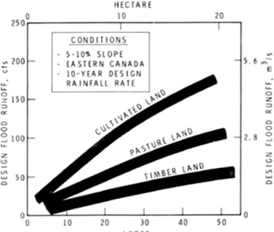
enormously, the amount depending on several variables such as area to be drained, soil type, slope, and type of vegetation removed. Some estimated maximum runoff rates for different types of vegetated land are shown on Figure 1. These values indicate that removal of trees from small watersheds can increase the maximum rate of runoff by as much as a factor of three. Although these values will not apply at every site, they do indicate that clearing land for urban development can result in much higher maximum runoff. This means that drainage channels that have been adequate under natural conditions may not be able to handle the increased flow after land has been cleared.
Figure 1. Surface runoff from varying terrain.
For example, using the values from Figure 1, the maximum flood runoff from 50 acres of timbered land might require an open ditch with 6-ft bottom width, flowing about 2 ft deep (assuming a certain slope and cross-section). If the area is to be cleared for development the potential maximum runoff could be increased threefold, doubling the required depth of flow for the same hydraulic conditions. Unless the ditch is designed for this, it will overflow, with consequent flooding, erosion and silting problems at the construction site.
There are few factual studies on the increased erosion that can take place at development sites during construction. One in the United States has indicated that erosion on land going into use for highways, houses or shopping centres can be ten times greater than that of land in
cultivated row crops, 200 times greater than that of land in pasture, and 2000 times greater than that of land in timber. Soil type and slope will also influence the relative amount of sediment produced from construction sites. Some studies indicate that if the slope of the terrain is increased from 5 to 10 per cent, the erosion rate can be doubled.
Studies of erosion from agricultural land in Canada indicate that on erodible soil up to 66 tons/hr of topsoil can be lost from one acre during a severe rainstorm. Erosion can also take place during rapid snowmelt runoff, although there is little or no danger of erosion in most parts of Canada during the winter when the surface layers of soil are frozen.
Preliminary Assessment
The time to consider control of drainage and erosion is in the initial planning of a project when a property is being evaluated for building purposes. A preliminary assessment should be made by competent specialists to determine whether there will be drainage and erosion problems as well as to estimate the cost of control. All possible sources of information should be tapped, including soil maps, climatological information, ground water data, air photographs, and geological maps.
The following check-list contains some of the factors that should be considered in this preliminary assessment:
Type of Soil - Is it highly erodible? Soils high in sand content tend not to erode so much as those high in clay. Sandy loams and soils with high organic content allow water to penetrate, reducing surface flow. The erosion taking place before construction, as evidenced by gulleys and ravines, provides a good indication of the erodibility of the soil.
Topography - The steeper the slope the greater the runoff and the greater the potential for erosion. The length of slope can also be important; the longer the slope, the greater the potential for erosion. One must consider also that providing drainage for uneven, steep topography will be more difficult and costly.
Vegetation - Trees and most vegetation are highly effective in protecting soil from erosion. In the preliminary planning phases it may be necessary to leave large areas of vegetated land untouched in order to prevent excessive erosion.
Rainfall and Snowfall - The most serious erosion takes place during short intense rainstorms. Rainfall records should be examined to assess the probability of intense rainfall at the site. Snowfall records should also be examined at sites where snowmelt runoff can be high.
Grading - Will the project be developed in stages or will most of the site be graded at one time? The scheduling of grading is most important in assessing potential erosion.
Downstream Drainage - Are the downstream drainage channels adequate? What is the potential for damage to downstream property because of increased runoff or increased sediment load from the construction site?
Contributing Watersheds - Will upstream water discharge or other developments contributing runoff to the site under study be factors? A watershed map showing all developments in the area is often useful.
Basic Principles of Drainage and Erosion Control
Drainage, erosion and sedimentation problems can be controlled effectively if two basic
principles are followed in the treatment of land: (1) the smallest area of soil should be left bare for the shortest time possible; (2) surface runoff should be controlled and its velocity reduced as much as possible.
The construction schedule for development of the site will have a considerable impact on how effectively these principles can be followed. If land is developed in stages it is much easier to control erosion because only small areas need be left bare of vegetation during the construction period. The planning of the permanent streets and drainage for development can also help determine how these principles can be followed. If the streets and sewers are installed before construction, even a large development site can be broken down into smaller areas, thus limiting the length of slope and potential erosion problems. It should be appreciated, however, that permanent drainage facilities, including storm sewers, may not be adequate during the construction period. They will be designed to handle only the flow from the completed project, with permanent buildings, roads and culverts, and established lawns. It is unlikely that they will be adequate to handle drainage during the construction period without supplemental
provisions.
Guidelines For Drainage and Erosion Control
Grading - Grade only those areas going into immediate construction. The graded areas must have sufficient slope to prevent ponding; a minimum grade of about 0.5 to 1.0 ft/100 should be sufficient. Steep slopes should be avoided. In some situations it may be feasible to construct terraces along the side of a slope to intercept flowing water and prevent erosion; fill small gulleys and compact fill; stabilize larger gullies by grading their slopes. Occasionally, heavy cutting, filling or reshaping of the natural topography will be needed to increase the percentage of usable land. Extensive grading almost always increases erosion hazards and will require special precautions to prevent excessive erosion.
Temporary Groundcover - One of the most effective means of controlling erosion and retarding runoff is through the use of temporary groundcover. Fast-germinating rye grasses, mulch, sprayed liquid asphalt, various types of jute and special mattings are some of the types of groundcover available. Straw mulch can be used to protect slopes and other areas brought to final grade at an unfavourable time for seeding. The areas can be seeded later without removing the mulch. Seeding can be accomplished quite economically by means of modern
hydromulching methods in which seed, fertilizer and mulch are applied as a slurry in a
mechanized operation that requires little labour. If it is planned to leave the cover permanently, special care will be necessary to select plants that are best suited to a particular site and
region.
Sediment Basin - A sediment basin is designed to detain runoff and hence reduce peak flows as well as trap sediment. Basins may be formed by the construction of small earth retainer dams across a waterway, using excavation obtained from the area to be used as a sediment trap for the dam. Sediment basins are usually temporary structures; after construction when the area has been stabilized, they can be graded down to become part of the final landscape.
If storm sewers have been installed prior to construction at the site, small temporary sediment basins may be needed to prevent excess sediment from entering the storm sewers.
Diversions - These consist of a water channel and ridge constructed across a slope to divert runoff. Diversions need a stable outlet into a suitable drainage channel to dispose of water safely. If the outlet is down a steep slope it may in some cases need to have temporary paving or a series of temporary check dams to prevent excessive erosion.
Berms are a type of diversion that can be used to protect newly constructed slopes until they have become stabilized with permanent vegetation. They consist of compacted earth ridges usually constructed across a slope in series to intercept runoff. The side slopes are made flat enough to allow work vehicles to cross over them.
Bench terraces can also be used as a type of diversion for erosion control. If the site is suitable, they can be made wide enough to be used as residential sites.
Drainage Outlets - Any system of drainage, temporary or permanent, requires an adequate outlet where the drainage waters can be discharged safely. In many cases well-defined natural channels will act as outlets and all that need be done is ensure that these channels will handle the additional runoff and possible sediment discharge from the development.
Drainage Channels - If new main ditches have to be designed to carry runoff, engineering advice will be needed. The ditches should have sufficient capacity to carry the expected
maximum discharge, which will depend on several variables such as expected maximum rate of rainfall (CBD 156). They should also be designed for a velocity that will not cause erosion of the ditch. In general, this will be determined by the grade of land and the soil types in the
development. It may be necessary to use small check dams or drop structures to limit
velocities where erosion would otherwise occur. The side slopes of a ditch will be determined by the material through which it passes. Soils such as coarse sands require quite a gentle slope for stability. Some slopes may require sodding to prevent excessive erosion and give the ditch sides stability. Special attention should be given to the establishment of grass waterways, especially to the kinds of grass that can tolerate submergence.
Subsurface - Tile or gravel drains are sometimes useful at the base of slopes or in areas where heavy grading has filled natural drainage channels. These drains are used to lower water tables and prevent areas with poor drainage conditions. They are often a part of the permanent drainage facilities, particularly at sites subject to frost heaving problems. Engineering advice is needed for the design of any extensive subsurface drainage system.
Runoff Storage - Sandy areas having high infiltration rates can be used as "soakways" to absorb surplus storm runoff that would otherwise flood downstream sections of a development. Man-made lagoons or small lakes may also be used to store excess runoff. These storage methods are usually part of the permanent drainage plan, but they can also be used to control drainage during the construction period where site conditions demand their use.
Concluding Remarks
Control of drainage and erosion at a construction site is as important during construction as after completion and should receive the same attention. It has been advocated that
most building detail. This may not be necessary if developers realize that temporary drainage and erosion control measures can save money in the long term, particularly if they can be treated as part of a permanent site plan to save the cost of repairing damaged terrain as well as precious construction time during wet periods.
Bibliography
Canada, Department of Agriculture. Soil erosion by water, Ottawa, 1972.
U.S. Department of Agriculture. Controlling erosion on construction sites, Soil Conservation Service, Agriculture Information Bulletin 347, December 1970.
Wolman, M.G., and P.A. Schick. Effects of construction on fluvial sediment, urban and suburban areas of Maryland, Water Resources Research, Vol. 3, No. 2, 1967, p. 451- 462.
Canada, Department of Public Works, Landscape and Site Development. Design Branch, Department of Public Works, March 1971.
Neal, W. Specifying erosion control during construction, Construction Specifier, January 1976, p. 26-32.