HAL Id: hal-02316021
https://hal-brgm.archives-ouvertes.fr/hal-02316021
Preprint submitted on 15 Oct 2019
HAL is a multi-disciplinary open access
archive for the deposit and dissemination of
sci-entific research documents, whether they are
pub-lished or not. The documents may come from
teaching and research institutions in France or
abroad, or from public or private research centers.
L’archive ouverte pluridisciplinaire HAL, est
destinée au dépôt et à la diffusion de documents
scientifiques de niveau recherche, publiés ou non,
émanant des établissements d’enseignement et de
recherche français ou étrangers, des laboratoires
publics ou privés.
An Analogue Approach to Characterize the
Basement-Sediment Transition Zone as a Geothermal
Reservoir
Chrystel Dezayes, Catherine Lerouge, Alexandra Kushnir, Michael Heap,
Patrick Baud, Jean-François Girard, Mathieu Darnet, Julien Porté, Samantha
Neeb, François Chabaux, et al.
To cite this version:
Chrystel Dezayes, Catherine Lerouge, Alexandra Kushnir, Michael Heap, Patrick Baud, et al.. An
Analogue Approach to Characterize the Basement-Sediment Transition Zone as a Geothermal
Reser-voir. 2019. �hal-02316021�
Proceedings World Geothermal Congress 2020 Reykjavik, Iceland, April 26 – May 2, 2020
An Analogue Approach to Characterize the Basement-Sediment Transition Zone as a
Geothermal Reservoir
Chrystel Dezayes1, Catherine Lerouge1, Alexandra Kushnir2, Michael Heap2, Patrick Baud2, Jean-François Girard2, Mathieu Darnet1, Julien Porte1, 2, Samantha Neeb1, 2, François Chabaux3, Julien Ackerer3, Albert Genter4, Vincent
Maurer4
1
BRGM, 3 avenue Claude Guillemin, BP 6009, 45060 Orléans, France
2
IPGS-EOST Strasbourg University, 5 rue Descartes, 67084 Strasbourg, France
3
LyGHeS, Strasbourg University, 1 rue de Blessig, 67084 Strasbourg, France
4
ES-Géothermie, Bâtiment Belem, 5 Rue de Lisbonne, 67300 Schiltigheim, France [email protected]
Keywords: Upper Rhine Graben, Triassic, Hercynian, sandstone, arkose, granite, gneiss, schist, fracture, mineralogy, fluid-rock
interaction, age dating, petrophysics, geophysics.
ABSTRACT
The development of geothermal exploitation in the Upper Rhine Graben for heat and power generation requires detailed knowledge of the subsurface in order to mitigate associated geological risk and streamline exploitation techniques.
In this area, several industrial projects have targeted the basement-sediment transition zone as a permeable reservoir. This is because the zone is located at a depth range where the temperature reaches values between 120 and 200 °C, which is economically exploitable for industrial heat or electricity. However, this zone is complex. Additionally, its geothermal potential is strongly affected by different types of heterogeneities, such as lithology, fracture networks and/or the geometry.
Multidisciplinary and multiscale approaches are used on various sites (deep and shallow boreholes and quarries) to characterize the transition zone: structural analysis of the fracture network that constitutes the deep fluid pathway, geophysical investigations to image the geometry of this zone, fluid-rock interaction studies and petrophysical characterization to reconstruct paleo-fluid circulations and identify the most efficient fluid pathways.
The various results are gathered into a conceptual model of the hydraulic behaviour of the transition zone for the sites and then used to develop new models to inform geothermal energy exploitation in this context.
1. INTRODUCTION
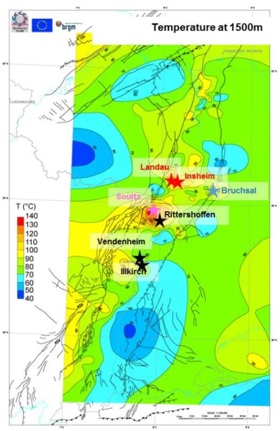
In the Upper Rhine Graben, most of geothermal projects for industrial heat or power generation target the transition zone between the basement and the sedimentary cover located at depth where the temperature is adequate (120°C-200°C) (Figure 1). Therefore, the development of such projects requires detailed knowledge of the subsurface in order to mitigate associated geological risk and streamline exploitation techniques. In addition to temperature, two other conditions are required for geothermal energy exploitation from depth are the presence of a geothermal fluid that acts as a heat vector and a reservoir permeability sufficiently high to produce and re-inject this natural fluid.
The CANTARE-Alsace project, funded by the ANR (French Research Agency) and steered by three academic partners (BRGM, CNRS and University of Strasbourg as LyGHeS and IPGS laboratories) and one local industrial partner (ES-G), aims to acquire a better knowledge of the basement-sediment transition zone in the Rhine Graben. This zone is indeed complex in term of geometry, fracture network, sediment filling and water-rock interactions, and these heterogeneities strongly affect its geothermal potential. The characterization of this transition zone and its heterogeneities poses a great challenge, although not unheard of in the development of geothermal resources exploitation in deep basins throughout Europe.
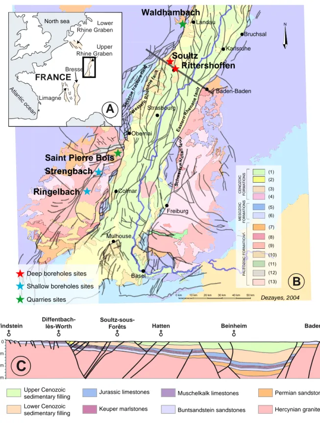
We examine the basement-sediment transition both inside the Rhine Graben by working on deep boreholes (Soultz-sous-Forêts, ca. 5 km; Rittershoffen, ca. 3 km), and outside the graben, on the Western flank of the Rhine Graben, by selecting relevant analogues (Figure 2). Analogue candidates are the Ringelbach site in the Vosges Massif (France), where two 150 m-deep boreholes crosscut the basement-sediment transition between ca. 25 and 75 m depth, and the Strengbach catchment in the Vosges Massif (France), where several shallow boreholes, 50 to 120 m deep were drilled in the upper part of the basement close to the sediment layers that outcrop less than 2 km to the east. Two quarries also offer access to outcrops of the transition zone: Saint Pierre Bois in France and Waldhambach in Germany.
Multidisciplinary and multiscale approaches are used to characterize the transition zone in these sites: 1) structural analysis of the fracture network that constitutes the deep fluid pathway, 2) mineralogical, geochemical and petrophysical studies of fracture fillings and fluid-wall rock interactions in granite and sediments to reconstruct paleo-fluid circulations, and 3) geophysical investigations to image the geometry.
Figure 1: Present-day and future exploitation geothermal site on temperature map at 1 500 m depth within the Rhine Graben (data from LIAG). The colors of stars indicate the targeted reservoir: red: sedimentary cover-basement transition,
pink: granitic basement, black: fault zones at the transition cover-basement zone, blue: deep sediments. 2. GEOLOGICAL CONTEXT AND APPLICATION SITES
The Upper Rhine Graben is a Cenozoic graben belonging to the West European Rift System (Figure 2-A) (Ziegler et al., 1992), which is very well-known because of numerous studies for petroleum and mining exploration (boreholes, geophysical surveys, etc.). The graben, roughly oriented N20°E (Figure 2-B), is filled by Tertiary and Quaternary sediments with minor volcanics. This Tertiary cover (500 to 1000 m thick) overlays the Jurassic (about 150 m thick) and Triassic (about 700 m thick) sediments and the Paleozoic crystalline basement (Figure 2-C).
The crystalline basement is the result of the Hercynian orogeny, which NE-SW sutures occurred in the main tectonic phases at the Carboniferous (Sudete phase) and Permian (Saalian phase) (Ziegler, 1986; Oncken et al., 1999). In the Vosges (Schneider, 1984) and at the western graben border (Villemin et al., 1986), these phases induced brittle tectonic with main fracture sets oriented N45°E, N135°E and N-S for the Carboniferous phase and N60°E to N90°E and N120°E for the Permian phase.
At the end of the Hercynian orogeny, the erosion of the chain led to local extension-related basin subsidence and rhyolitic volcanic activity during Late Carboniferous-Early Permian (Eisbacher et al., 1986). These fault-controlled basins generate the NW direction in the Vosges and the Black Forest massifs (Figure 2-B).
After a large period of sedimentation during Triassic and Jurassic with deposition of clastic and carbonate sediments, the area was uplifted from the late Jurassic to early Eocene. Taphrogenesis occurred during the Tertiary, between the end of the Eocene and the Miocene (Roussé, 2006), due to reactivation of a fault zone, inherited from the Hercynian tectonic under the Africa-Europe collision (Schumacher, 2002; Edel et al., 2006).
In the southern part, the Vosges and Black Forest massifs were uplifted during Mio-Pliocene, probably following the alpine phase (Wyns, 1999). Presently, the altitude difference for the Triassic and the Paleozoic basement limit between the summit of the Vosges massif and the deeper part of the central graben is about 3000-4000 m (Figure 2-C), providing evidence of substantial vertical displacement.
Dezayes et al. Geomorphologically, the structure of the Rhine Graben is characterized by a slightly sinuous form: the northern part trends N-S, the central part trends N30°E and the southern part N10°E (Figure 2-B). The boundaries of the graben are controlled by two types of large synthetic normal faults: the internal (Rhenane) and the external (Vosgian and Schwarzwaldian) faults. These limit crescent-shaped fracture fields, such as the Saverne fracture field (Figure 2-B).
Figure 2: Location of sites used as analogues for studying basement-sediment transition zone of the Upper Rhine Graben. A. Location of the Upper Rhine Graben in Western Europe. B. Schematic geological map showing location of sampling
sites, quarries and wells (1) Quaternary fluvial deposits; (2) Quaternary loess, eolian deposits; (3) Tertiary marine and lacustrine limestones, marls, evaporites; (4) Tertiary basalt; (5) Jurassic limestones; (6) Triassic sandstones, marly limestones, anhydrite (German Trias); (7) Permian red sandstones; (8) Carboniferous volcanism; (9) Carboniferous granites; (10) Dinantian conglomerate; (11) Ordovician-Silurian Limestones and continental altered rocks; (12) Ordo-Silurian-Cambrian clay and argillaceous sandstones; (13) Siluro-devonian paragneiss and orthogneiss. C. - Geological W-E
cross-section through Soultz-sous-Forêts based on 3D geological model from GeORG Team (2013).
Mulhouse Basel Colmar Freiburg Obernai Strasbourg Baden-Baden Karlsruhe Landau Bruchsal Heidelberg Mannheim Darmstadt Frankfurt Worms Dezayes, 2004
B
Sa vern efr ac ture field Wes tern Rh e na ne fau lt Vo sg ian fau lt Ea ste rn Rhe na ne fau lt Sc hw art z w al d ia n fa ul t Beinheim Baden-Baden Hatten Soultz-sous-Forêts Diffentbach-lès-Worth Windstein 0 -2km -4km -6kmC
Lower Rhine Graben Upper Rhine Graben Limagne Bresse North sea A tla ntic oc eanFRANCE
A
Saint Pierre Bois
Waldhambach
Soultz
Rittershoffen
Strengbach
Ringelbach
(1) (2) (3) (4) (5) (6) (8) (9) (7) (10) (11) (12) (13) 0 km 10 km 20 km 30 km 40 km 50 km N P A L E O Z O IC F O R M A T IO N S M E S O Z O IC F O R M A T IO N S C E N O Z O IC F O R M A T IO N S Lower Cenozoic sedimentary filling Upper Cenozoicsedimentary filling Jurassic limestones
Keuper marlstones Muschelkalk limestones Buntsandstein sandstones Permian sandstones Hercynian granite Quarries sites
Deep boreholes sites Shallow boreholes sites
Six sites have been selected for the study of the transition zone: two are deep boreholes sites inside the graben, Soultz-sous-Forêts and Rittershoffen, two are quarries on the shoulders of the graben, Saint Pierre Bois and Waldhambach, and two are observatory sites for environment studies with shallow boreholes, Ringelbach and Strengbach, also on the shoulders of the graben (Figure 2-B). The Soultz-sous-Forêts site is the first European EGS (Enhanced Geothermal System) experimental site (Gérard and Kappelmeyer, 1987), where five boreholes have been drilled since 1987: two relatively shallow exploratory wells (GPK-1 and EPS-1) were drilled to a depth of 3600m and 2200m respectively, and three for reservoir development and heat exploitation at 5000 m depth (GPK-2, GPK-3 and GPK-4) (Baumgärtner et al., 2004). The specific reservoir is located in the granitic basement at 1400 m depth beneath Mesozoic and Cenozoic sediments. EPS-1 was fully cored starting at 800 m depth and provided cores from Triassic limestone and sandstones to granitic basement, including the whole of the transition zone between the sedimentary cover (Genter and Traineau, 1992). This site is now an industrial site led by GEIE EMC and has produced electricity since 2016.
The Rittershoffen boreholes are located 6 km southeast of the Soultz site (Figure 2-B). They were drilled in 2012 and 2014 as part of the ECOGI project associating Roquette frères, Electricité de Strasbourg and the Caisse des Dépôts. The project produces geothermal steam to dry starch in the Roquette factory located close to the Rhine River. The target of the geothermal exploitation is the base of the sediment and the top of the granite basement, which is deeper than at Soultz-sous-Forêts at around 2200m. No cores are available from these boreholes, but different logs and recent seismic profiles have been acquired and are the exclusive use of ES-Géothermie, one of the partners of the project (Baujard et al., 2017).
The Ringelbach catchment site is located near Soultzeren (Haut-Rhin) on the eastern side of the Vosges Massif (Figure 2-B) and covers an area of 0.36 km2 in which interdisciplinary studies on water cycle dynamics have been conducted since 1976 (Ambroise, 1995). The Triassic sandstones overlay the granitic basement. Three boreholes were drilled within the catchment and cross-cut the transition zone: two reached a depth of 150 m and the third one to a depth of 80 m, in order to characterise the alteration profile (Wyns, 2012; Schaffhauser et al., 2014; Lucas et al., 2017).
Like the Ringelbach catchment, the Strengbach catchment (80 ha) is located on the eastern side of the Vosges Massif (Figure 2-B). The bedrock is a Ca-poor Hercynian leucogranite, covered by a small band of gneiss along the catchments northern edge. In order to better characterize the deeper part of the catchment, six boreholes were drilled in 2013 and 2014 between 50 and 120 m depth, three of which have been cored (Chabaux et al., 2017). The sedimentary cover is not present in the boreholes but exists to the east of the catchment.
The Waldhambach and Saint Pierre Bois quarries are located near the western border of the Rhine Graben in the German and the French part respectively (Figure 2-B). In both quarries, basement rocks are exposed just under the base of basin filling. Therefore, the transition zone of sedimentary cover and basement is relatively easily accessible (Dezayes et al., 2011).
3. METHODS
The methodology is based on four approaches that will enable an overall characterization of the transition zone between the sedimentary cover and the basement:
- Structural analysis to identify the different tectonic phases and establish the relationship between the fracture/fault sets and fracture/fault infilling through collecting datasets about the fracture/fault network and determining the relationship of these networks between the sedimentary cover and the basement. A structural survey of the transition zone and also of the large fault zones intersecting the transition zone was performed in detail (fracture distribution, density, orientation, filling, etc.) to characterize fracture network pattern and the evolution of its large fault zone in relation to the different tectonic phases and their chronology. - Water/rock interactions to define circulation cells in the studied areas, establishing the timing of the fluid circulations through the different major fracture and fault sets (ancient versus present-day fluid circulations) and their impact on the evolution of circulation cells (porosity opening or clogging) through geological time. A detailed petrographic study (mineralogy, textural relationships) combined with a geochemical (oxygen, carbon, sulphur and strontium) isotopic study, along with fluid-inclusion microthermometry, was performed to identify and characterize (temperature, chemistry, origin) different generations of fluids and to advance our understanding of the fluid paleocirculations.
- Petrophysical investigations to determine the evolution of the petrophysical parameters (porosity, permeability, elastic wave velocities and electrical and thermal conductivity) along the transition zone. The borehole samples were prepared in three orthogonal orientations to highlight the in situ anisotropy of the measured physical properties. This study provides a full set of petrophysical data to inform on the hydro-thermo-mechanical coupling processes in deep geothermal reservoirs and serve as a database for future reservoir modelling.
- Geophysical survey to evaluate the sensitivity of surface geophysical measurements: electrical resistivity and seismic velocity. Electrical conductivity has been widely used in geothermal prospecting due to its relevance to fluid and weathering. Resistivity measurements were performed on analogue sites using DC and EM methods.
This complete multidisciplinary and multiscale investigation involves high-level interaction between the four approaches. Therefore, all the studies were performed at the same sites described above.
Dezayes et al.
4. RESULTS
Since most of the results are yet to be published, the key take-home points are presented in this section for each discipline. Finally, these data are discussed together.
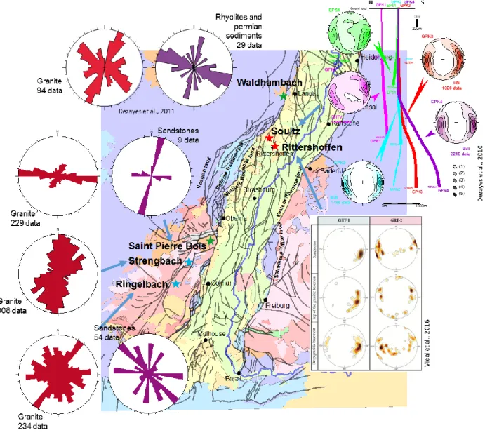
A database of fracture orientation and description have been performed based on previous studies (Dezayes et al, 2010; Dezayes et
al, 2011; Vidal et al., 2016) and completed by measurements performed in the framework of this study (Figure 3). All of them
show the N-S direction and other directions as NE-SW, NW-SE and E-W (Figure 3).
The amount of data in the Permo-Triassic sediments is always lower than the amount of data for the basement (Figure 3), usually due to the fact that the sediment outcrops are not much developed and not much accessible. Except at Saint Pierre Bois, where the main fracture set is N20°E in the sandstones and N100°E in the granite, the direction of fracture is rather the same in the basement and in the sediments.
At Saint Pierre Bois, we observe that some of large E-W faults in the basement continue in the sedimentary cover, but some of them are stopped by the sedimentary layers.
Figure 3: Orientation of fractures for the different sites. Data for Soultz from Dezayes et al., 2010, Waldhambach from Dezayes et al., 2011 and Rittershoffen from Vidal et al., 2016.
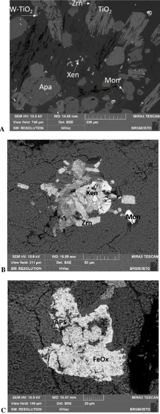
The major fractures and faults was formed during the Hercynian provide dark surfaces in the field and consist of cohesive fracture/fault rocks (breccia and cataclasite) due to pronounced silicification and minor illite formation (Lerouge and Dezayes, 2017). At the transition zone, alteration of Ca-bearing primary minerals such as plagioclase, amphibole or titanite in biotite-amphibole granites or gneiss, and Ca-rich accessory minerals such as apatite and monazite in two-mica granite are a Ca source for further precipitation of hydrothermal carbonates (dolomite/ankerite, calcite) in fractures, shown at Ringelbach, Strengbach and Waldhambach. On another hand, the alteration of K-feldspar seems to be a possible source for Ba for the precipitation of hydrothermal barite in fractures at Ringelbach, Saint Pierre Bois, Strengbach and Waldhambach (see Chabaux et al., 2019 for surface circulation in the Strengbach case). Research dedicated to using accessory authigenic minerals to date hydrothermal fluid circulations provides evidence of xenotime, titanium oxides, and As-Ba-Sr-REE-bearing alumina-phosphates associated with Mg-rich illite (Figure 4).
A
B
C
Figure 4: Backscattered Scanned Electron microscope image of accessory minerals. A- Strengbach; B- Saint Pierre Bois; C- Ringelbach. Zrn zircon, TiO2 with and without W, Xen xenotime, Mon monazite, Apa apatite, APS
aluminum-phosphate-sulfates.
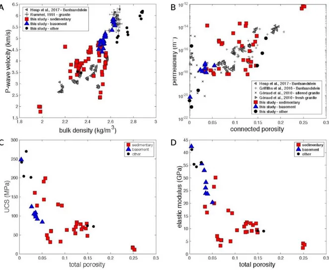
The exploration of the petrophysical variation present across the transition zone shows that the sedimentary rocks are more permeable (Figure 5-B), have lower P-wave velocity (Figure 5-A), lower compressive strength (Figure 5-C) and lower elastic modulus (Figure 5-D) than the basement rocks (Griffith et al., 2016; Heap et al., 2017; see also data in Kushnir et al., 2018a; Villeneuve et al., 2018; Heap et al., 2018, 2019, submitted). The porosity of the rocks is generally low and results from a high quartz cementation and to dissolution of plagioclase and K-feldspar (Kushnir et al., 2018b).
Dezayes et al.
Figure 5: A. P-wave velocity as a function of bulk density (Kushnir et al., 2018b). Grey triangles are data for Permo-Triassic sandstones from the EPS-1 exploratory borehole at Soultz-sous-Forêts, France (Heap et al., 2017); Grey squares are data for granite from the GPK-1 borehole at Soultz-sous-Forêts, France (Rummel 1992). Each square is the average value for a
given depth and the error bars give the standard deviation. B. Permeability as a function of connected porosity. We compare the data gathered in this study with data for the Permo-Triassic sandstones (Griffiths et al., 2016; Heap et al., 2017) and granite (Géraud et al., 2010) from the EPS-1 exploratory borehole at Soultz-sous-Forêts, France. C. Uniaxial
compressive strength of the sedimentary rocks investigated in the present study. D. Elastic modulus of the rocks investigated in the present study. The rocks from this study are categorised as either being sedimentary (red squares), from
the crystalline basement (blue triangles), or as being other lithologies (black circles).
Thermal properties are not particularly related to lithology but thermal conductivity decreases with increasing porosity (Figure 6; Kushnir et al., 2018b). Two submitted manuscripts (Harlé et al., submitted; Heap et al., submitted) present thermal property data for the sedimentary cover.
Figure 6: Thermal conductivity of rocks from Saint Pierre Bois, Raon l’Etape, Waldhambach, and Albersweiler as a function of total porosity. All investigated rocks are categorised as either sedimentary (red squares), or as being other
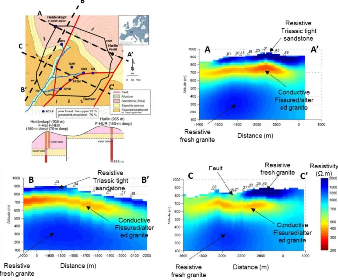
The Ringelbach catchment is particularly adapted to subsurface geophysical investigations due to the shallow depth of the sediment - basement transition. Electro-magnetic and seismic soundings have been carried out to map the electrical resistivity and P-wave velocity distribution within the transition zone (Figure 7 and Figure 8).
A 3D Controlled Source Electro-Magnetic (CSEM) survey over a 1000 m × 1000 m area cutting through the transition zone was acquired (Darnet et al., 2019). The 3D resistivity cube obtained from the inversion of such data shows that the conductive anomaly associated with altered and fractured zone extends over 200 m into the basement and is laterally extensive. It also shows that this conductive zone is mainly developed in the granite at varying depth below the base of the sedimentary cover and varies laterally (from zero to 200 m depth) (Figure 7).
Figure 7: Results of CSEM inversion Top left: geological map of the Ringelbach area with location of the resistivity cross-sections. Top right and bottom: Resistivity cross-sections A-A’, B-B’ and C-C’ obtained from the inversion of 3D
Controlled-Source Electro-Magnetic data (Darnet et al., 2019).
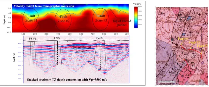
A 2D reflection seismic profile has been acquired over the Triassic sedimentary cover cutting through three fault zones identified in the area. A clear velocity drop from 4000-5000 m/s down to 3500-4000 m/s is observed at the top of the crystalline basement (within the first 100 m) when crossing these faults (Figure 8). Similarly, reflectors associated to layering within the basement fade away when crossing these fault zones, possibly indicating the presence of strongly altered and fractured granite. Interestingly, numerous and continuous reflectors are present within the basement, possibly caused by some layering in the alteration, as evidenced by the layering observed on the sonic logs in the exploratory boreholes.
Dezayes et al.
Figure 8: Results of the 2D reflection seismic profile. Righ: geological map of the Ringelbach area with the location of 2D seismic line. Left top: Velocity model derived from the travel-time inversion of first breaks. Bottom: stacked migrated
section in depth (Darnet et al., 2019). 5. DISCUSSION
The main set of fractures is N-S direction in relation to the main direction of the graben and related to the opening of the graben (Schumacher, 2002). Other directions as NE-SW, NW-SE and E-W are present and are related to Hercynian tectonics (Edel et al., 2007). However, the direction appears in relation with local tectonics depending on the location. The fracture density is lower in the sandstones than in the granitic basement, which went through more tectonic phases. However, the Hercynian direction affects the direction of fracture in the first sedimentary layers above the basement. The paleo-circulation is particularly important in the NE-SW, NW-SE and E-W fractures. At Saint Pierre Bois, the E-W fractures are very large and show some traces of filling and are related to the Villé basin opening during the Permian at the end of the Hercynian orogenesis.
The petrophysical properties measured across the transition zone are highly variable (Heap et al., 2017; Kushnir et al., 2018a, b; Heap et al., 2018, 2019, submitted). Whereas the sandstones are more permeable than the basement, they show a plugged matrix as a result of the paleocirculation of deep fluids.
The presence of accessory minerals on both sides of the cover/basement transition confirms that circulating paleofluids mobilized trace elements from the Hercynian basement on a large scale through the cover/basement transition prior to the opening of the graben (Dezayes and Lerouge, 2019).
At a larger scale, geophysical surveys reveal the geometry and complexity of the basement-sediment transition zone, with the presence of large-scale electrically conductive zone and seismic reflectors layering through the several hundred meter thickness in the altered top of the basement.
6. CONCLUSIONS
Although the transition zone between crystalline basement and the sedimentary cover is a target for geothermal exploitation, it appears that this zone is complex and shows various heterogeneities, in terms of fracture network, permeability and other geophysical properties, and geometry. This on-going work highlights these heterogeneities and, in the future, could present one or several conceptual models for the geological object in order to help the building of more realistic THM models for developing geothermal exploitation in this kind of system.
AKNOWLEDGEMENT
The authors thank the owners of quarries for the access of the sites.
The research leading to these results has received funding from the ANR Programme under grant agreement ANR-15-CE06-0014 (Project CANTARE-Alsace).
REFERENCES
Ambroise B. Topography and the water cycle in a temperate middle mountain environment: the need of interdisciplinary experiments. Agric. For. Meteorol (1995). 73: 217-235.
Baujard C., Genter A., Dalmais E., Maurer V., Hehn R., Rosillette R., Vidal J. Geothermics Hydrothermal characterization of wells GRT-1 and GRT-2 in Rittershoffen , France : Implications on the understanding of natural flow systems in the rhine graben.
Geothermics (2017) 65, 255–268. doi:10.1016/j.geothermics.2016.11.001
Baumgärtner,J., Hettkamp T., Teza D., Baria R; and Michelet S. Building of a Hot Dry Rock scientific power plant at Soultz-sous-Forêts. Geothermal Ressources Council Transactions (2004), Vol. 28, p. 201-206.
Chabaux F., Viville D., Lucas Y., Ackerer J., Ranchoux C., Bosia C., Pierret M.C., Labasque T., Aquilina L., Wyns R., Lerouge C., Dezayes C., Negrel P, Geochemical tracing and modeling of surface and deep water– rock interactions in elementary granitic watersheds (Strengbach and Ringelbach CZOs, France) - Acta Geochimica,Acta Geochim (2017) 36:363–366
Chabaux F., Stille P., Prunier P., Gangloff S., Lemarchand D., Morvan G., Négrel J., Pelt E., Pierret MC, Rihs S., Schmitt A.-D., Trémolières M., Viville D. Plant-soil-water interactions: Implications from U-Th-Ra isotope analysis in soils, soil solutions and vegetation (Strengbach CZO, France) Geochimica et Cosmochimica Acta 259 (2019) 188–210.
Darnet M., Dezayes C., Girard J.-F., Baltassat J.-M., Lerouge C., Reuschlé T., Coppo N., Bretaudeau F., Porté J., Lucas Y. Geophysical signature of the transition zone between the sedimentary cover and the basement: an analogue approach to help de-risking geothermal prospects. European Geothermal Congress (2019), Den Haag, The Netherland, 11-14 June 2019. Dezayes C., Genter A., Valley B. Structure of the low naturally fractured geothermal reservoir at Soultz. CR Geosciences (2010),
Vol.342, n°7-8, p.517-530.
Dezayes C., Capar L., Beccaletto L., Lerouge C. Etude de la partie Trias - Permien - toit du socle dans le Fossé Rhénan pour des applications de géothermie profonde. Rapport final (2011) BRGM Report BRGM/RP-60387-FR: 101 p.
Dezayes C., Lerouge C. Reconstructing paleofluid circulations at the Hercynian basement/sedimentary cover interface in the Upper Rhine graben. Geofluids (2019), vol. 2019, Article ID 4849860, 30 pages. https://doi.org/10.1155/2019/4849860.
Edel J.-B., Schulmann K., and RotsteinY. The Variscan tectonic inheritance of the Upper Rhine Graben: evidence of reactivations in the Lias, Late Eocene–Oligocene up to the recent. International Journal of Earth Sciences, (2006). 96: p. 305-325.
Eisbacher G.H., Lüschen E., and Wickert F. Crustal-scale thursting and extension in the Hercynian Schwartzwald and Vosges Central Europe. Tectonics (1989). 8: p. 1-21.
Genter A., Traineau H. Borehole EPS-1, Alsace, France: preliminary geological results from granite core analyses for Hot Dry Rock research. Scientific Drilling (1992), V. 3, p. 205-214.
GeORG Team, Potentiel géologique profond du Fossé Rhénan Supérieur. Partie1- Rapport Final. (2013). BRGM/RP-61945-FR. Gérard A., Kappelmeyer O. The Soultz-sous-Forêts project. Proceedings of the first EEC/US workshop on geothermal Hot dry
Rocks Technology., Geothermics (1987) Special issue: 393-399.
Géraud Y., Rosener M., Surma F., Place J., Le Garzic E., Diraison M. Physical properties of fault zones within a granite body: Example of the Soultz-sous-Forets geothermal site. Comptes Rendus Geoscience (2010) 342 (7-8):566-574. doi:10.1016/j.crte.2010.02.002.
Griffiths L., Heap M.J., Wang F., Daval D., Gilg H.A., Baud P., Schmittbuhl J., Genter A. Geothermal implications for fracture-filling hydrothermal precipitation. Geothermics (2016) 64:235-245. doi:10.1016/j.geothermics.2016.06.006.
Harlé P., Kushnir A.R.L., Aichholzer C., Heap M.J., Hehn R., Maurer V., Baud P., Richard A., Genter A., Duringer D. Heat flow estimations in the Upper Rhine Graben using laboratory measurements of thermal conductivity on sedimentary rocks, submitted.
Heap M.J., Kushnir A.R.L., Gilg H.A., Wadsworth F.B., Reuschlé T., Baud P. Microstructural and petrophysical properties of the Permo-Triassic sandstones (Buntsandstein) from the Soultz-sous-Forêts geothermal site (France). Geothermal Energy (2017) 5 (26). doi:10.1186/s40517-017-0085-9.
Heap M. J., Reuschlé T., Kushnir A. R., Baud P. The influence of hydrothermal brine on the short-term strength and elastic modulus of sandstones from exploration well EPS-1 at Soultz-sous-Forêts (France). Geothermal Energy (2018), 6(1), 29. Heap M. J., Villeneuve M., Kushnir A. R., Farquharson J. I., Baud P., Reuschlé T. Rock mass strength and elastic modulus of the
Buntsandstein: an important lithostratigraphic unit for geothermal exploitation in the Upper Rhine Graben. Geothermics (2019), 77, 236-256.
Heap M.J., Kushnir A.R.L., Gilg H.A., Violay M.E.S., Harlé P., and Baud P. Petrophysical properties of the Muschelkalk from the Soultz-sous-Forêts geothermal site (France), an important lithostratigraphic unit for geothermal exploitation in the Upper Rhine Graben, submitted.
Kushnir A. R., Heap M. J., Baud P. Assessing the role of fractures on the permeability of the Permo-Triassic sandstones at the Soultz-sous-Forêts (France) geothermal site. Geothermics (2018a), 74, 181-189.
Kushnir A.R.L., Heap M.J., Baud P., Gilg H.A., Reuschlé T., Lerouge C., Dezayes C. Characterising the physical properties of the transition zone from the Paleozoic basement to the overlying Permo-Triassic sedimentary sequences in the Upper Rhine Graben. Geothermal Energy (2018b) 6:16, https://doi.org/10.1186/s40517-018-0103-6.
Lerouge C., Dezayes C. Fluid circulation at the cover/granite interface in the Rhine Graben. EGU (2017) - 23–28 Avril 2017 – Vienna.
Lucas Y., Chabaux F., Schaffhauser T., Fritz B., Ambroise B., Ackerer J., Clément A. Hydrogeochemical modeling (KIRMAT) of spring and deep borehole water compositions in the small granitic Ringelbach catchment (Vosges Mountains, France). Applied
Geochemistry (2017) 87, 1–21.
Oncken, O., von Winterfeld C., and Dittmar U., Accretion of a rifted passive margin : The Late Paleozoic Rhenohercynian fold and thrust belt (Middle European Variscides). Tectonics (1999). 18: p. 75-91.
Roussé, S. Architecture et dynamique des séries marines et continentales de l’Oligocène moyen et supérieur du sud du Fossé rhénan : évolution des milieux de dépôt en contexte de rift en marge de l’avant pays alpin. (2006). p. 474.
Dezayes et al. Rummel F. Physical Properties of the Rock in the Granitic Section of Borehole GPK1, Soultz-sous-Forêts. In: Bresee JC (ed) (1992) Geothermal Energy in Europe: The Soultz Hot Dry Rock Project. Gordon and Breach Science Publishers, Switzerland. Schaffhauser T., Chabaux F., Ambroise B., Lucas Y., Stille P., Reuschlé T., Perrone T., Fritz B. Geochemical and isotopic (U, Sr)
tracing of water pathways in the granitic Ringelbach catchment (Vosges Mountains, France). Chemical Geology (2014) 374-375: 117-127.
Schneider C. Les granitoïdes de la partie Nors-Est des Vosges moldanubiennes: evolutions magmatique et structural. (1984). PhD thesis of Strasbourg University.
Schumacher M.E. Upper Rhine Graben: Role of preexisting structures during rift evolution. Tectonics, (2002). 21: p. 6-1-6-17. Vidal J., Genter A., Chopin F., Dalmais E. Natural fractures and permeability at the geothermal site Rittershoffen, France European
Geothermal Congress (2016), Strasbourg, France, 19-24 Septembre 2016
Villemin, T., Alvarez F., Angelier J., The Rhinegraben: extension, subsidence and shoulder uplift. Tectonophysics (1986). 128: p. 47-59.
Villeneuve M. C., Heap M. J., Kushnir A. R., Qin T., Baud P., Zhou G., Xu T. Estimating in situ rock mass strength and elastic modulus of granite from the Soultz-sous-Forêts geothermal reservoir (France). Geothermal Energy (2018), 6(1), 11.
Wyns, R., Contraintes géologiques et géomorphologiques à l’histoire de la mobilité verticale de la lithosphère continentale en Europe de l’ouest depuis le Crétacé : relations avec la genèse des grabens et du volcanisme tertiaires, in Colloque « Volcanismes, sédimentations et tectoniques cénozoïques périalpins », P. Nehlig, Editor. (1999), Doc. BRGM, 291: Aurillac. p. 46-47.
Wyns R. Etude géologique du cadre structural et des forages du bassin versant de recherche du Ringelbach (Soultzeren, Haut-Rhin). BRGM Report (2012) BRGM/RP-56540-FR.
Zhu W, Baud P, Wong T-F. Micromechanics of cataclastic pore collapse in limestone. Journal of Geophysical Research (2010). doi:10.1029/2009JB006610.
Ziegler P.A., Geodynamic model for the paleozoic crustal consolidation of western and central Europe. Tectonophysics (1986). 126: p. 303-328.