RESEARCH OUTPUTS / RÉSULTATS DE RECHERCHE
Author(s) - Auteur(s) :
Publication date - Date de publication :
Permanent link - Permalien :
Rights / License - Licence de droit d’auteur :
Institutional Repository - Research Portal
Dépôt Institutionnel - Portail de la Recherche
researchportal.unamur.be
University of Namur
FLEXPUB
Crompvoets, Joep; Bouckaert, Geert; Snoeck, Monique; HABRA, Naji; De Terwangne,
Cecile; Vanden Berghe, Ingrid; Chantillon, Maxim; Kruk, Rink ; Simonofski, Anthony; Tombal,
Thomas; Kruk, Rink W.
Publication date: 2020
Document Version
Publisher's PDF, also known as Version of record
Link to publication
Citation for pulished version (HARVARD):
Crompvoets, J (ed.), Bouckaert, G, Snoeck, M, HABRA, N, De Terwangne, C, Vanden Berghe, I, Chantillon, M, Kruk, R, Simonofski, A, Tombal, T & Kruk, RW 2020, FLEXPUB: Public E-Service Strategy : Report WP5 : FLEXPUB - Work Package 5 : Case studies. Belgium Science Policy , Bruxelles.
General rights
Copyright and moral rights for the publications made accessible in the public portal are retained by the authors and/or other copyright owners and it is a condition of accessing publications that users recognise and abide by the legal requirements associated with these rights. • Users may download and print one copy of any publication from the public portal for the purpose of private study or research. • You may not further distribute the material or use it for any profit-making activity or commercial gain
• You may freely distribute the URL identifying the publication in the public portal ? Take down policy
If you believe that this document breaches copyright please contact us providing details, and we will remove access to the work immediately and investigate your claim.
BRAIN-be
BELGIAN RESEARCH ACTION THROUGH INTERDISCIPLINARY NETWORKS
Work Package Report
Sent to [email protected]
Contract nr. BR/154/A4/FLEXPUB
Project – FLEXPUB
WP 5 – Case studies
Period : 01/11/2016 – 31/05/2020
D/2020/10107/003
NETWORK
COORDINATOR
Prof. dr. ir. Joep Crompvoets (KU Leuven – Public Governance Institute)
PARTNERS
• Prof. dr. Geert Bouckaert – Prof. dr. Ir. Joep Crompvoets (KU Leuven – Public Governance
Institute)
• Prof. dr. Monique Snoeck (KU Leuven – Research Centre for Management Informatics)
• Prof. dr. Naji Habra – Dr. Benoit Vanderose (UNamur – Research Centre on Information
Systems Engineering)
• Prof. dr. Cécile De Terwangne (UNamur – Research Centre on Information, Law, and Society)
• Ir. Ingrid Vanden Berghe – Jan De Waele (National Geographic Institute of Belgium)
AUTHORS
1. Prof. dr. ir. Joep Crompvoets (KU Leuven – Public Governance Institute)
2. Prof. dr. Monique Snoeck (KU Leuven – Research Centre for Management Informatics)
3. Prof. dr. Naji Habra – Dr. Benoit Vanderose (UNamur – Research Centre on Information
Systems Engineering)
4. Prof. dr. Cécile De Terwangne (UNamur – Research Centre on Information, Law, and Society)
5. Maxim Chantillon (KU Leuven – Public Governance Institute)
6. Rink Kruk (National Geographic Institute of Belgium)
7. Dr. Anthony Simonofski (KU Leuven – Research Centre for Management Informatics)
8. Thomas Tombal (UNamur – Research Centre on Information, Law and Society)
TABLE OF CONTENTS
NETWORK
2
EXECUTIVE SUMMARY
4
1. INTRODUCTION
6
2. METHODOLOGY
9
O
VERALL METHODOLOGICAL APPROACH... 9
C
ASE1:
B
ES
TA
DDRESS... 11
Questionnaire development ... 11
Interview selection ... 12
Field Observation ... 13
Desk research ... 13
C
ASE2:
C
ADASTRALI
NFORMATIONS
HARING... 14
Questionnaire development ... 14
Interview selection ... 14
Desk research ... 16
C
ASE3:
E
MERGENCYS
ERVICES... 16
Questionnaire development ... 16
Interview selection ... 16
Desk Research ... 17
3. CASE STUDY RESULTS
18
C
ASE1:
B
EST ADDRESS... 18
Background ... 18
Analysis ... 22
Recommendations ... 37
C
ASE2:
C
ADASTRALI
NFORMATIONS
HARING... 48
Background ... 48
Analysis ... 53
Recommendations ... 65
C
ASE3:
E
MERGENCYS
ERVICES... 69
Analysis ... 70
Recommendations ... 74
4. CROSS-CASE ANALYSIS
77
5. IMPACT ON WP6 STRATEGY AND WP7 BLUEPRINT
84
C
ASE1:
B
ES
TA
DDRESS... 84
C
ASE2:
C
ADASTRALI
NFORMATIONS
HARING... 85
C
ASE3:
E
MERGENCYS
ERVICES... 89
6. CONCLUSION
90
BIBLIOGRAPHY
91
ANNEX
93
A
NNEX1
–
Q
UESTIONNAIRE FORB
ES
TA
DDRESSC
ASE STUDY... 93
A
NNEX2
–
Q
UESTIONNAIRE FORC
ADASTRAL INFORMATION SHARING... 95
EXECUTIVE SUMMARY
FLEXPUB aims to contribute to the development of a federal strategy for enabling flexibility, adaptability and innovation in the public sector with a focus on a next generation of geospatial electronic services (e-services). It is expected that the public e-services will continuously change as citizens have higher expectations towards them and technological developments provide new possibilities. During the last two decades, the Belgian federal government and administration have taken significant steps to satisfy (tomorrow’s) stakeholders, i.e. citizens, businesses and public organisations.
“Work Package 5 - Case studies” (hereafter WP5) aims to present the challenges that were faced in three case studies having a strong link to location-based data and to echo these challenges with the key requirements for future e-service delivery by the federal administration identified in WP3 of the FLEXPUB research project. Moreover, WP5 aims at testing the strategic actions suggested in the Draft Strategic Vision for Location-based e-Services (WP6) and the guidelines suggested in the Draft Blueprint on Adaptive and Innovative Government (WP7) by confronting them to real-life scenarios. This iterative process will then allow to refine these strategic actions and guidelines.
The research is executed on the basis of case study research, whereby a multi-method approach is taken. Whereas WP2 and WP3, which focused on the analysis of challenges and requirements for geospatial e-services in the Belgian federal context, aimed to create a broad horizontal overview, the researchers applied, for this WP5, a methodology which allowed to gain an in-depth knowledge of three constellations in which geospatial data constitute the core of the e-service(s) that is/are offered or that might be offered in the future. The combination of a horizontal methodological approach in WP2 and WP3 and the in-depth approach in this WP5 created a complementarity that supports and underpins WP6 and WP7. As stated in the Methodology Chapter, the researchers based themselves on the expertise that can be found in the academic literature.
Three cases were selected for this WP, based on (1) the proposals put forward by the Members of the Follow-up Committee, and (2) the relevancy of the proposed cases compared to the results of WP2. The three selected and studied cases are the BeSt Address Project (BeSt Address & related aspects), the exchange of cadastral information in Belgium (URBAIN & Regional Relations) and the functioning of the emergency services in Belgium (FPS Interior Affairs / ASTRID Dispatching). The first two cases make use of geospatial information which is crucial for geospatial e-services: addresses and cadastral information. Both cases are also internally oriented. This means that the focus lies on the collaboration between public administrations, and not on the relation with external non-governmental organisations. The third case is focused on a key function of the state: Offering security and safety to its citizens. Each of the cases is structure around the COBIT enablers used in WP3, namely Processes; Organisational structures; Service infrastructure & applications; People, skills & competencies; Culture, ethics & behaviour; Principles, policies & frameworks; Semantics and Location-based data. For all three case studies, the researchers made findings that could be related to one of the seven COBIT enablers. This demonstrates, once more, that the development of e-services is a highly complex phenomena which is influenced by various factors that influence each other. Indeed, several of the findings are not just connected to one enabler but have an overlap between various enablers. Each of the case studies contains a number of findings which are highly relevant for the overall geospatial e-services context, and can support administrations in their quest for flexible and innovative e-services. For each of the case studies, the researchers provide a number of recommendations, based, on the one hand, on the information supplied via the respondents, the observations and the document analysis, and, on the other hand, on the project expertise in reaction to the requirements. This had led to a number of case specific and general recommendations, which are summarised in Chapter 3 – Case study results.
Then, on the basis of this analysis, some cross-case issues are identified in Chapter 4. Indeed, even if these cases all aim at tackling different problems, they face similar cross-cutting issues. In essence, nine cross-case issues are identified: i) Improving data quality; ii) Aiming for interoperability and standardisation; iii) Offering trainings to the civil servants; iv) Agreeing on Open Data licences; v) Defining authoritative sources of data; vi) Improving communication; vii) Streamlining cooperation; viii) Solving financial shortcomings; and ix) Increasing user
participation and inclusion.
Finally, as the overall goal of those three case studies was to further refine the Strategy (WP6) and the Blueprint (WP7), the general recommendations, for each pillar, are discussed, in Chapter 5, in connection to the draft strategic actions and guidelines suggested in the draft Strategy and Blueprint.
1. INTRODUCTION
FLEXPUB aims to contribute to the development of a federal strategy for enabling flexibility, adaptability and innovation in the public sector with a focus on a next generation of geospatial electronic services (e-services). It is expected that the public e-services will continuously change as citizens have higher expectations towards them and technological developments provide new possibilities. During the last two decades, the Belgian federal government and administration have taken significant steps to satisfy (tomorrow’s) stakeholders, i.e. citizens, businesses and public organisations.
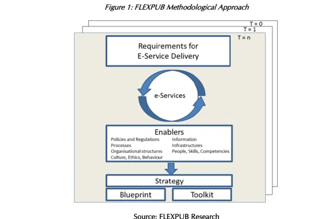
“WP2 – Baseline Measurement” allowed the research team to understand the current situation about e-services in Belgium. The following step was to identify, in “WP3 – Requirements”, the needs, ideas and requirements that the administrations have in order to be able to offer more flexible and innovative e-services, as well as the barriers that they face in doing so. The data was gathered and structured via the COBIT enablers (Processes; Organisational structures; Service infrastructure & applications; People, skills & competencies; Culture, ethics & behaviour; Principles, policies & frameworks; Location-based data and Semantics). On the basis of these requirements, the research team suggested, in “Work Package 4 – Enablers”, leads for solutions to fulfil those needs and overcome those barriers. These requirements and leads for solutions were then used by the research team to suggest strategic actions in “Work Package 6 - Strategic Vision for Location-based e-Services” and to suggest guidelines in “Work Package 7 - Blueprint on Adaptive and Innovative Government”.
Figure 1: FLEXPUB Methodological Approach
Source: FLEXPUB Research
The goal of “Work Package 5 - Case studies” is double. On the one hand, it aims to present the challenges that were faced in three case studies having a strong link to location-based data and to echo these challenges with the key requirements for future e-service delivery by the federal administration identified in WP3 of the FLEXPUB research project. On the other hand, it aims at testing the strategic actions suggested in the Draft Strategic Vision for Location-based e-Services (WP6) and the guidelines suggested in the Draft Blueprint on Adaptive and Innovative Government (WP7) by confronting them to real-life scenarios. This iterative process will then allow the research team to refine these strategic actions and guidelines.
To do so, a selection of three case studies closely linked to location-based data was made, on the basis of input the team received from the Members of the Follow-up Committee and of the relevancy of the proposed cases for the project, in light of the results of previous WPs. These cases are the following:
Case 1: BeSt Address
The BeSt Address project strives for the unification of the way of referencing addresses and the way of linking address data. To do so, the project aims to unify the references used for addresses, in particular by making recommendations on data models; to maintain the reference of addresses according to a Belgian standard; and to unify the rules for the allocation of addresses. This will make it possible to geolocate in a secure and unambiguous way, within administrations, each street and each address1. To do so, each Region will manage a register of
addresses (authentic source) for its own territory.
This case, which focusses on a key type of location-based data, namely addresses, was signalled by a significant number of members of the Follow-up Committee as it includes various stakeholders (at the Federal, Regional and Local level), as it forms the basis for a well-functioning geospatial infrastructure, and as it has a strong historical-legacy (the premises of the project started at beginning of the 21st century), all of which is highly relevant to test the
previous findings of the FLEXPUB project. Case 2: Emergency Services in Belgium
A case study pertaining to the cartographic system of emergency services, with a specific focus on dispatching (ASTRID), was originally suggested by a member of the Follow-up Committee. After internal discussion, the research team decided to broaden this case study. Instead of focusing only on ASTRID, attention will go to the broader context of emergency services in Belgium. ASTRID nevertheless remains the starting point for this case study. This case is relevant for FLEXPUB as it encounters several recurrent problems such as maintaining and automatically updating data, or the difficulty to include external data. Moreover, a number of technical challenges linked to the mapping of emergencies have been signalled. Yet, a well-functioning emergency system is part of the basic tasks of the State.
Case 3: Exchange of Cadastral Information
Cadastral information is managed by the federal public service Finance, and more precisely the General Administration for Patrimonial Information. This information is shared with partners at the federal, regional and local level, whereby the information is used for several policy goals. There are two main policy goals of cadastral information. On the one hand, there is a taxation purpose: the cadastral revenue is set on the basis of a number of factors, and it serves as a taxation basis for the various Belgian administrations. On the other hand, the cadatral information is used in the urban planning. This case study focused on the exchange of cadastral information in the Belgian federal context, and attempted to create an overview of the different challenges and requirements faced by the administrations working with the data.
This case, which focusses on a key type of location-based data was signalled by a number of stakeholders at different administrative levels. This is because the cadastral system is increasingly used by different stakeholders for urban planning, while it was originally created as a tool to tax landowners. Moreover, the complex organisational relations between the federal, regional and local administrations, especially regarding synchronisation of information, is a useful case study for the FLEXPUB project.
The rest of the report is organised as follows. Chapter 2 presents the overall methodological approach as well as the specific methodology used for each of the three cases. Chapter 3 presents, for each case studies, a number of findings which are highly relevant for the overall geospatial e-services context, and can support administrations in
1 Accord de coopération du 22 janvier 2016 entre l'Etat fédéral, la Région flamande, la Région wallonne et la Région de
Bruxelles-Capitale concernant l'unification de la manière de référencer les adresses et de la mise en relation des données d'adresses, M.B., 15 février 2016. Available at http://www.ejustice.just.fgov.be.
their quest for flexible and innovative e-services. For each of the case studies, the researchers also provide a number of case specific and general recommendations. Chapter 4 relies on the analysis conducted in Chapter 3 in order to indentify some some cross-case issues. Indeed, even if these cases all aim at tackling different problems, they face similar cross-cutting issues. In essence, nine cross-case issues have been identified: i) Improving data quality; ii) Aiming for interoperability and standardisation; iii) Offering trainings to the civil servants; iv) Agreeing on Open Data licences; v) Defining authoritative sources of data; vi) Improving communication; vii) Streamlining cooperation; viii) Solving financial shortcomings; and ix) Increasing user participation and inclusion. As the overall goal of those three case studies was to further refine the Strategy (WP6) and the Blueprint (WP7), Chapter 5 discusses the general recommendations, for each pillar, in connection to the draft strategic actions and guidelines suggested in the draft Strategy and Blueprint. Chapter 6 concludes.
2. METHODOLOGY
OVERALL METHODOLOGICAL APPROACH
This Work Package was executed on the basis of case study research, whereby a multi-method approach was taken. Whereas WP2 and WP3, which focused on the analysis of challenges and requirements for geospatial e-services in the Belgian federal context, aimed to create a broad horizontal overview, the researchers applied, for this WP, a methodology which allowed to create an in-depth analysis of three constellations in which geospatial data constitutes the core of the e-service(s) that is/are offered or that might be offered in the future. The combination of a horizontal methodological approach in WP2 and WP3, and the in-depth approach in this WP, creates a complementarity that supports and underpins WP 6 and WP7. For the execution of the case studies, the researchers based themselves on the expertise that can be found in the academic literature, such as the work of, among others, Flyvbjerg (2006)andYin (1981, 2003, 2014).
At the start of the FLEXPUB project, in 2016, the members of the Follow-up Committee were asked to suggest potentially relevant case studies. The members were asked to inform the researchers about case studies with a geospatial orientation as well as an e-service orientation. In total 16 case studies were suggested. An overview of these suggested case studies can be found in the table hereunder. In 2016 a first selection of the case studies was made on the basis of three main criteria and seven minor criteria. The three main criteria are: (1) internally oriented e-services of the federal government, (2) externally oriented e-services of the federal government with a traditional oriented focus and (3) externally oriented e-services of the federal government with a non-traditional geo-oriented focus. The seven minor criteria are (1) usability of the case, (2) innovativeness of the case, (3) effectiveness of the case, (4) applicability of the case, (5) flexibility of the case, (6) overall impact of the case and (7) adaptability of the case to the changing environment. On the basis of those ten criteria, in total five cases were selected as being relevant for Work Package 5. Those cases were BeAlert, URBAIN & Regional relations, INFRABEL Railway Data Distribution, FPS Interior Affairs / ASTRID Dispatiching, and BeSt Address & related aspects.
Follow-up Committee Suggested Case Studies
BeAlert Regional traffic signs database
Proximus Analytics Identification of black points on the road
URBAIN & Regional relations European Location Framework
INFRABEL Railway Data Distribution Crossroads Bank for Points of Interest
IRM-KMI-ULG Start-up Aangifte van Werken – Déclaration de Travaux &
Checkinatwork
FPS Interior Affairs / ASTRID Dispatching BeSt Address & related aspects (POI – hectometre points)
State Archives Digitalisation: AAPD Geo-OptiFed 1
e-TOD Operational Cartography for Wildfire Fighting
At the Scientific Meeting of 18 May 2017, three cases were selected as final case studies for the project, based on (1) the proposals put forward by the Members of the Follow-up Committee, and (2) the relevancy of the proposed cases compared to the results of WP 2. The three selected and studied cases were as such part of this original list: The BeSt Address Project (BeSt Address & related aspects), the exchange of cadastral information in Belgium (URBAIN & Regional Relations) and the functioning of the emergency services in Belgium (FPS Interior Affairs /
ASTRID Dispatching). The first two cases make use of geospatial information which is crucial for geospatial e-services: addresses and cadastral information. Both cases are also internally oriented. This means that the focus lies on the collaboration between public administrations, and not on the relation with external non-governmental organisations.
The third case is focused on a key function of the state: Offering security and safety to its citizens. As can be seen from the titels of the cases, the researchers decided to broaden the scope of the third case study (emergency services). This was decided at the end of 2018. Furthermore, a meeting took place with one of the key actors of this case to further specify the scope of the case study. Originally it was only focused on ASTRID but the functioning of the emergency services in general, in which ASTRID is embedded as a key actor, proved to be more valuable for the purpose of this research. The case thus focussed on the governance of emergency systems, the information management of the data related to emergency services and the legal system in which the emergency services operate. This case is both internally and externally oriented: The focus lies also on the relation with the external users, and not only on the relation with the internal governmental actors.
Once the team presented the Strategic Vision for Location-based e-Services (WP6) in May 2018 to the Members of the Follow-up Committee, the team started to work actively on the case studies. In the period May 2018 – October 2018 attention was devoted to the selection of the relevant actors for each of the case studies, the preparation of the questionnaire and the development of the overall methodological framework. In December 2018 – January 2019, the first interviews were scheduled, and the interviews were launched in February 2019. The majority of the interviews took place in the first half of 2019, with a few remaining interviews taking place in the autumn of 2019. The same methodological approach was applied for all three cases. The team created a questionnaire for each case study, based on the draft Strategy and Blueprint of WP 6 and WP 7 and a first understanding of the case which was studied. This questionnaire was then used for the interviews. Besides the interviews, the team also conducted desk research, and more specifically a document analysis for each of the three cases. The document selection was a combination of purposive sampling and snowball sampling (Bryman, 2016). Some documents were known by the researchers, others were signalled to the researchers by the interviewees and a final group of documents was retrieved on the basis of guidance via the two above-mentioned groups of documens. Finally, the team was allowed as observer to the BeSt Address Committee Meetings, so for this case also a field observation took place. This was not the case for the two other case studies. An overview of the approaches can be found in the table below. Overall, it can be said that a multi-method approach was followed for the case study research.
Case Study Approach Case 1 – BeSt Address Case 2 – Exchange of Cadastral
Information
Case 3 – Emergency Services
Semi-structured Interviews Semi-structured Interviews Semi-structured Interviews
Document Analysis Document Analysis Document Analysis
Field Observation
All interviews were recorded, with the permission of the respondent(s) and transcribed afterwards. All respondents received the transcript afterwards and had the possibility to inform the researchers about issues related to the transcriptions. The analysis of the interview transcriptions was conducted via NVivo 12, a software program used for the analysis of qualitative text material. Coding via this specific software allowed for an objective analysis of the data. NVivo 12 is widely used for qualitative research. The data for all three case studies was structured around (1) the COBIT enablers, and in particular the identified challengens of WP2, and (2) the WP6/7 Strategy and Blueprint structure (De Haes, Van Grembergen, & Debreceny, 2013). In this way the case studies of this work package allowed for a direct connection to the other work packages.
Overall, the methodological approach can be summarised in the following graph:
Step Action Timing
Step 1 Case study selection 2016 – 2017
Step 2 Case study refinement 2018
Step 3 Case study preparation - interviews / document analysis / field observations 2018 – 2019
Step 4 Case study data collection 2019
Step 5 Case study data analysis 2019
Step 6 Case study reporting 2019 - 2020
Hereunder the different methodological steps for each of the three case studies can be found. First the methodology of the BeSt Address case study is presented, followed by the methodology of the cadastral information exchange case. Finally, more methodological information of the third case study, emergency services, is provided.
CASE 1: BEST ADDRESS
The methodology used for the BeSt Address case study relied on a combination of three research approaches, namely (i) interviews with selected actors having a key role in the project, (ii) field observation, (iii) and desk research.
QUESTIONNAIRE DEVELOPMENT
In order to have more coherence and consistency during the interviews that were conducted with key actors of the BeSt address project, a questionnaire containing a specific set of questions was developed by the FLEXPUB research team.
As one of the aims of the case study was to test the strategic actions suggested in the Draft Strategic Vision for Location-based e-Services (WP6) and the guidelines suggested in the Draft Blueprint on Adaptive and Innovative Government (WP7) by confronting them to real-life scenarios, the questions were structured according to the four pillars used for the Draft Strategy (Openness2, Participation3, Collaboration4 and Geo-Orientation5) and echoed the
suggestions made therein. The questions pertaining to the first three pillars6 also echoed the guidelines made in the
2
Openness is about sharing information and services as broadly as possible, when possible for free, in a secure and privacy compliant manner, in order to increase transparency and foster economic growth through collaboration and data re-use, and to generate value-added services.
3
Participation is about involving all the stakeholders impacted by the digitalisation strategy, by taking into account their evolving requirements, needs, ideas or necessary training. This participation is essential to be able to match the expectations of the stakeholders regarding the e-services.
4 Collaboration is about the administration’s organisations embracing an ever more globalising world and society, in which
they no longer act as single actors, but strive from an administration wide perspective towards alliances, cooperation and the sharing of data, tools and capacity to fulfil their tasks and duties towards a variety of stakeholders (public, private and citizens).
5 Geo-orientation is about generating added value by answering the increasing demand for real-time and geo data and
location-based services. This is not only relevant within a group of specialised actors, but also for actors from other policy fields, which might not always realise the potential of including a location component in their services. “What?”, “When?” and “Where?” are the three simple questions that are to be considered in any e-service offered.
draft Blueprint, which is more general in scope and does not have a specific focus on location-based data. This questionnaire can be found in Annex 1.
INTERVIEW SELECTION
The BeSt address project is piloted by an “Address committee”, created by article 7 of the Cooperation agreement of 22 January 2016 underlying the project7. Therefore, it was clear for the research team that the key actors that
should be interviewed, in order to collect their experience about the project and to see whether the Draft Strategy presents useful solutions or, on the contrary, should be adapted in certain respects, were the members of this committee.
However, given that it would have been too time consuming to meet all the members of the Address committee, a sampling approach was taken. This sampling approach aimed to match the balance found in the composition of this Address committee. Indeed, article 7 of the Cooperation agreement of 22 January 2016 provides that it is composed of two reprensatitives of each Region; two representatives of the Flemish and Walloon local communities; one representative of the Brussels and German community local communities; and six representatives of the Federal partners. There is thus a perfect balance (6 - 6 - 6) between the Federal, Regional and Local levels. The sampling made for the interviews aimed to match this balance, as the aim was to conduct nine interviews in order to meet the three Regions, three Federal partners, and three representatives of the local communities. In the end, eight interviews were conducted instead of nine, as it was only possible to meet two representatives of the local communities because the others never followed-up on the research team’s invitation.
These interviews are the following:
Date Level Administration Relevance
6 February 2019 Regional Flemish Region - AIV Manager of the register of Flemish addresses (CRAB)
14 February 2019 Regional Walloon Region – Geomatic Department
Manager of the register of Walloon addresses (ICAR)
20 February 2019 Federal FPS BOSA Develops the information exchange platform
25 February 2019 Federal FPS Economy – KBO/BCE Key future user of the Regional registers 25 February 2019 Regional Brussels Region – CIRB Manager of the register of Brussels addresses
(URBIS)
27 March 2019 Local VVSG Represents the Flemish local communities,
who are the adresses’ initiators 18 April 2019 Federal FPS Interior – National
Register
Key future user of the Regional registers
4 June 2019 Local Local community Represents the Walloon local communities,
7 Accord de coopération du 22 janvier 2016 entre l'Etat fédéral, la Région flamande, la Région wallonne et la Région de
Bruxelles-Capitale concernant l'unification de la manière de référencer les adresses et de la mise en relation des données d'adresses, M.B., 15 février 2016. Available at http://www.ejustice.just.fgov.be.
who are the adresses’ initiators FIELD OBSERVATION
As indicated above, the BeSt address project is piloted by an “Address committee”, created by article 7 of the Cooperation agreement of 22 January 2016 underlying the project8, which meets on a montly basis on average.
Therefore, it was clear for the research team that it was necessary to attend those meetings, in order to observe the discussions that occurred between the members and to understand where the difficulties lie. Moreover, these meetings were highly valuable in order to gather additional information about the progress status of the project. Via this field work, deeper insights were gained about the concrete challenges faced in the context of the project and about the working of the Address committee. These insights then allowed the researchers to ask, during the interviews, additional questions than those prepared in the questionnaire, in order to get individualised feedback by key members of the Address committee about discussion points that emerged during these meetings.
The team attended thirteen meetings of this “Address committee”:
2018 2019 2020 29 March 2018 5 June 2018 6 September 2018 8 November 2018 11 December 2018 24 January 2019 26 March 2019 2 May 2019 26 June 2019 25 September 2019 21 November 2019 21 January 2020 31 March 2020 DESK RESEARCH
The interviews and field observation were completed by desk research focussing on peripheric documents pertaining to the project. In this regard, the reports of the Address committee meetings were analysed, as well as the Cooperation agreement of 22 January 2016 between the Federal State, the Flemish Region, the Walloon Region and the Brussels-Capital Region on the unification of the way addresses are referenced and the linking of address data9; the Ministerial Circular "BeSt-Address - Guidelines and Recommendations for the Determination and
Assignment of an Address and Housing Number" of 23 February 2018 issued by Jan Jambon, Minister of Security and Interior10; the Instructions for maintaining information in the National Register of natural persons up-to-date
(Address of principal residence (TI 020) - New structure)11; and other background documents about the early stages
of the project.
8
Accord de coopération du 22 janvier 2016 entre l'Etat fédéral, la Région flamande, la Région wallonne et la Région de Bruxelles-Capitale concernant l'unification de la manière de référencer les adresses et de la mise en relation des données d'adresses, M.B., 15 février 2016. Available at http://www.ejustice.just.fgov.be.
9 Accord de coopération du 22 janvier 2016 entre l'Etat fédéral, la Région flamande, la Région wallonne et la Région de
Bruxelles-Capitale concernant l'unification de la manière de référencer les adresses et de la mise en relation des données d'adresses, M.B., 15 février 2016. Available at http://www.ejustice.just.fgov.be.
10 Circulaire ministérielle "BeSt-Address - Directives et recommandations pour la détermination et l’attribution d'une adresse
et d'un numéro d'habitation"du 23 février 2018 rédigée par Jan Jambon, Ministre de la Sécurité et de l'Intérieur :
https://www.ibz.rrn.fgov.be/fileadmin/user_upload/fr/rn/circulaires/BeSt_Address_Recommandations_20180223.pdf
11 SPF Intérieur, Direction générale Institutions et Population, Instructions pour la tenue à jour des informations au Registre
national des personnes physiques - Adresse de la résidence principale (TI 020) - Nouvelle structure, 26 janvier 2017 :
CASE 2: CADASTRAL INFORMATION SHARING
A combined qualitative research approach was followed for this case study, whereby the researchers decided to undertake the research by focusing on interviews and a document analysis (Bryman, 2016). It can, as such, be argued that a multi-method research approach was applied for this research. As discussed above, the two other cases had a similar research methodology. By applying a similar approach to the three cases, the comparability of the case study results in increased.
QUESTIONNAIRE DEVELOPMENT
In order to have more coherence and consistency during the interviews that were conducted with the selected actors related to the Cadastral Information Sharing, a questionnaire containing a specific set of questions was developed by the FLEXPUB research team.
As one of the aims of the case study was to test the strategic actions suggested in the Draft Strategic Vision for Location-based e-Services (WP6) and the guidelines suggested in the Draft Blueprint on Adaptive and Innovative Government (WP7) by confronting them to real-life scenarios, the questions were structured according to the four pillars used for the Draft Strategy (Openness12, Participation13, Collaboration14 and Geo-Orientation15) and echoed
the suggestions made therein. The questions pertaining to the first three pillars16 also echoed the guidelines made
in the draft Blueprint, which is more general in scope and does not have a specific focus on location-based data. Two specific comments need to be made here. It has to be underlined that the questionnaire served as a general backbone for the interviews. Firstly, depending on the specific expertise and/or role of the actor involved in the Cadastral Information Sharing, the questionnaire was modified. An example will clarify this: The actors from the local level were asked specific questions related to their local level, whereas the federal public service Finance received a number of specific questions related to their work. Secondly, during the interviews, and based on the responses of the interviewees, more in depth questions which were not taken up in the questionnaire were asked. Finally, it needs to be signalled that the federal public services Finance received, on their request, the questionnaire before hand. The other interviewees did not receive the questionnaire beforehand.
The general questionnaire which was created before defining the more specific questionnaires for the different interviewees can be found in Annex 2.
INTERVIEW SELECTION
The research applied two different selection approaches for the different governmental levels that were studied. For the federal administration as well as the regional administrations, a deliberate selection of the main actors was conducted. Because of earlier research and the active contacts with various actors involved in the cadastral information sharing context in light of the FLEXPUB project, the team was able to identify the main actors within the federal and regional administrations. The following organisations were contacted and granted the team an
12
Openness is about sharing information and services as broadly as possible, when possible for free, in a secure and privacy compliant manner, in order to increase transparency and foster economic growth through collaboration and data re-use, and to generate value-added services.
13
Participation is about involving all the stakeholders impacted by the digitalisation strategy, by taking into account their evolving requirements, needs, ideas or necessary training. This participation is essential to be able to match the expectations of the stakeholders regarding the e-services.
14 Collaboration is about the administration’s organisations embracing an ever more globalising world and society, in which
they no longer act as single actors, but strive from an administration wide perspective towards alliances, cooperation and the sharing of data, tools and capacity to fulfil their tasks and duties towards a variety of stakeholders (public, private and citizens).
15 Geo-orientation is about generating added value by answering the increasing demand for real-time and geo data and
location-based services. This is not only relevant within a group of specialised actors, but also for actors from other policy fields, which might not always realise the potential of including a location component in their services. “What?”, “When?” and “Where?” are the three simple questions that are to be considered in any e-service offered.
interview: FOD Financiën – SPF Finance, AIV, SPW – Département de la Géomatique, CIRB – CIBG and SCIP – CSPI.
At the local level, a random selection was conducted on all the local administrations of Belgium. A pool of local administrations was made for each of the three regions, i.e. Brussels Capital Region, Flemish Region and Walloon Region. From each of those three pools, a random selection of 10 local administrations was made. From this list of 10 local administrations, the first two were contacted for each region. In the Flemish Region and the Walloon Region this led to in total four successful interviews. In the Flemish Region the two first local administrations agreed with an interview. In the Walloon Region, the first local administration agreed, the second declined, and therefore the third local administration was contacted and agreed with an interview. In the Brussels Capital Region, however, the team was unable to find local administrations that were able to grant the reseachers with an interview. The researchers contacted all ten selected local administrations via mail and/or telephone, but none of them was willing to allow an interview. A combination of factors was mentioned: lack of time and resources, lack of interest, and lack of permission from the political level.
Date Level Organisation Relevance
1 October 2019 Federal FOD Financiën – SPF
Finance
Federal actor responsible for cadastral information.
17 April 2019 Inter-federal SCIP – CSPI Inter-federal organisation for the sharing
of patrimonial information.
21 May 2019 Regional SPW – Département de la
Géomatique
Actor responsible for the horizontal geospatial policy in the Walloon public administration.
9 May 2019 Regional CIRB – CIBG Actor responsible for the horizontal
geospatial policy in the Brussels Capital Region public administration.
30 July 2019 Regional AIV Actor responsible for the horizontal
geospatial policy in the Flemish public administration.
15 February 2019 Local Flemish Local Community Randomly selected local administration
updating and using cadastral
information.
20 February 2019 Local Flemish Local Community Randomly selected local administration
updating and using cadastral
information.
25 March 2019 Local Walloon Local Community Randomly selected local administration
updating and using cadastral
information.
9 August 2019 Local Walloon Local Community Randomly selected local administration
updating and using cadastral
DESK RESEARCH
Besides the interviews, the researchers conducted desk research in the form of a document analysis. The selection was a combination of purposive sampling and snowball sampling (Bryman, 2016). As explained above, the documents were selected on the basis of prior knowledge related to this topic, because of references made to documents by the interviewees and on the basis of links in those documents to other documents. The document analysis helped the case study research in a number of ways. Firstly, it allowed to gain an excellent insight in the factual organisation of the exchange of cadastral information in Belgium. Secondly, it provided the possibility to validate and clarify a number of findings that were mentionned by the interviewees. And finally, it allowed to unveil a number of good practices and challenges. The document analysis focused both on legally binding documents, as well as policy documents and online websites. Indeed, the website of the main organisations at the federal and regional level provided us with useful information which allowed to improve the factual knowledge on the case study. Also, the websites of the local administrations that provided the researchers with an interview were analysed to see if any relevant information related to the exchange of cadastral information could be found. Examples of the analysed documents are Cooperation Agreements, federal Laws and Royal Decrees, regional Ordonnances and Decrees. Policy documents are for example the SCIP – CSPI Operation and Strategic Plan and factual information sheets available via the website of the FOD Financiën – SPF Finance.
CASE 3: EMERGENCY SERVICES
The methodology used for this case study relied on the combination of two elements, namely a questionnaire was developed (i) in order to conduct interviews with selected actors having a key role in the project (ii).
QUESTIONNAIRE DEVELOPMENT
In order to have more coherence and consistency during the interviews that were conducted with key actors of the emergency systems ecosystem in Belgium, a questionnaire containing a specific set of questions was developed by the FLEXPUB research team.
As one of the aims of the case study was to test the strategic actions suggested in the Draft Strategic Vision for Location-based e-Services (WP6) and the guidelines suggested in the Draft Blueprint on Adaptive and Innovative Government (WP7) by confronting them to real-life scenarios, the questions were also structured according to the four pillars used for the Draft Strategy (Openness, Participation, Collaboration and Geo-Orientation) and echoed the suggestions made therein. The questions pertaining to the first three pillars also echoed the guidelines made in the draft Blueprint, which is more general in scope and does not have a specific focus on location-based data. This questionnaire can be found in Annex 3.
INTERVIEW SELECTION
In order to understand the ecosystem of stakeholders involved in the digitalisation of emergency services in Belgium, we decided to rely on a snowballing approach. Indeed, since the main focus of the case study was ASTRID, we started to conduct in-depth interviews with this organisation. From this central point, we then asked which stakeholders we should interview next, which led us to a list of other interviewees.
In the end, eight interviews were conducted. These interviews are the following:
Date Level Organisation Relevance
2 March 2017 Federal ASTRID Geographical expert ASTRID and general
overview of ecosystem and ASTRID
3 July 2018 Federal NGI Focus on Emergency System deployed for
17 July 2018 Private CapGemini Focus on Emergency Systems deployed for NATO Summit
28 September 2018
Federal ASTRID / DRI Geographical expert ASTRID, and
discussion on NATO and challenges
9 May 2019 Federal ASTRID Geographical expert ASTRID, first
validation of challenges and suggestion of other stakeholders to interview
22 May 2019 Federal Federal Police – Direction de l’information policière et
des moyens ICT (DRI)
Focus on users and federal collaboration
28 May 2019 Federal NGI Focus on data sources and data quality for
ASTRID
17 July 2019 Local Firefighters Focus of users and operators of emergency
system 19 November
2019
Local Digipolis Focus on innovative app to improve
emergency services DESK RESEARCH
On top of the conducted interviews, the researchers also performed desk research by analysing official documents and the websites of key organisations. The documents were selected on the basis of prior knowledge on the case and on references made by interviewees on the documents (specific questions were asked to the interviewees about potentially interesting documents). Examples of analysed documents include the challenges identified by ASTRID prior to the FLEXPUB project or the description of the ASTRID strategic goals and organigram.
Furthermore, we analysed the website of key organisations in the emergency services landscape such as ASTRID17,
Digipolis18 or DRI19. 17https://www.astrid.be/fr 18https://www.digipolis.be/ 19 https://www.police.be/5998/fr/a-propos/gestion-des-ressources-et-information/direction-de-linformation-policiere-et-des-moyens
3. CASE STUDY RESULTS
CASE 1: BEST ADDRESS
The BeSt Address project strives for the unification of the way of referencing addresses and the way of linking address data. To do so, the project aims to unify the references used for addresses, in particular by making recommendations on data models; to maintain the reference of addresses according to a Belgian standard; and to unify the rules for the allocation of addresses. This will make it possible to geolocate in a secure and unambiguous way, within administrations, each street and each address20.
Before presenting the results of the analysis that was done based on the interviews, field observation and desk research, and the recommendations derived therefrom, it is first necessary to provide some background about the history of this project and the way it is structured, in order to better understand its purpose and challenges.
BACKGROUND
HISTORY
From our understanding, the first cooperation discussions between the Federal and Regional governments on the sharing of information or the joint setting up of authentic sources and their use started in 2003 at the initiative of the land register (Cadastre). It was called GeoCodi (Common Geo Dictionary). It was focussed on a common dictionary for the land register and it wanted to deal with a number of themes, such as cadastral information and addresses. GeoCodi was succeeded by DiCo, which was composed of two working groups21, one dedicated to
addresses and one dedicated to buildings. DiCo was then followed by DiCoAddress, which would eventually become (later on) BeSt address.
During the first five years, from 2003 to 2007, not much progress had been made in terms of finding an agreement on how the Federal and Regional governments could cooperate in order to define a common address framework. This was because this implied difficult political discussions.
However, a European Directive, adopted in 2007, brought the discussion back and gave it a new momentum, namely the INSPIRE Directive22. This is because this Directive contained the obligation for Member States to
implement rules laying down technical arrangements for the interoperability and, where practicable, harmonisation of spatial data sets (Art. 7.1). According to the INSPIRE Directive, these implementing rules should notably provide for the creation of a common framework for the unique identification of spatial objects, amoung which addresses (Annex 1 of the Directive), to which identifiers under national systems can be mapped in order to ensure interoperability between them (Art. 8.2.a). These had to be adopted no later than 15 May 2009 (Art. 9.a).
Accordingly, in order to comply with the INSPIRE Directive, the discussions about the establishment of a common framework for the unique identification of addresses started over. This first led to the Cooperation agreement of 2 April 2010 between the Federal State, the Flemish Region, the Walloon Region and the Brussels-Capital Region for the coordination of a geographical information infrastructure23.
However, the topic of creating a common framework for addresses was still highly sensitive from a political point of view, and a specific Cooperation agreement on the unification of the way of referencing addresses and the way
20 Accord de coopération du 22 janvier 2016 entre l'Etat fédéral, la Région flamande, la Région wallonne et la Région de
Bruxelles-Capitale concernant l'unification de la manière de référencer les adresses et de la mise en relation des données d'adresses, M.B., 15 février 2016. Available at http://www.ejustice.just.fgov.be.
21
One of the interwiewees also mentioned a working group named Strategis, that was ran by the land register, which could be one of these two working groups but we were not able to check how Strategis was linked to GeoCodi or DiCo.
22
Directive 2007/2/EC of the European Parliament and of the Council of 14 March 2007 establishing an Infrastructure for Spatial Information in the European Community (INSPIRE), OJ L 108, 25 April 2007.
23
Accord de coopération du 2 avril 2010 entre l’État fédéral, la Région flamande, la Région wallonne et la Région de Bruxelles-Capitale pour la coordination d’une infrastructure d’information géographique, M.B., 12 avril 2011.
of linking address data was only adopted six years later, on the 22nd of January 201624.
As of this date, and through the means of the “Address committee” created by article 7 of this Cooperation agreement, representatives of the Federal, Regional and Local levels started working on this common address framework and on the integration of the three Regional registers (CRAB, ICAR and URBIS).
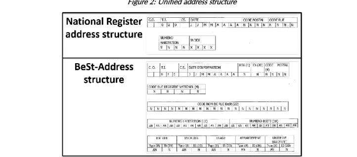
Figure 2: Unified address structure
Source: FLEXPUB (2019) based on the Instructions for maintaining information in the National Register of natural persons up-to-date – New TI 020 structure (2017)25
One of the missions of the “Address committee” was to set up a data exchange platform to connect the address registers and make the relevant address data contained in the address registers available to federal public authorities. It mandated the FPS BOSA to do so. Since 15 May 2019, the first two services (Full Download – including in Open Data - and Mutations) are operational. The other essential services were made available at the end of the summer of 2019. Finally, the secondary services, including the anomaly notification service, will be made available in spring 2020.
Finally, it should be mentioned that, for quite some time, there was an issue with the legal effect of the Cooperation agreement, as it took several years before it became clear that assenting laws and decrees were necessary in order to give legal effect to the Cooperation agreement26. This added some delay to the project as the legislation section
of the Council of State, which reviewed the Federal assenting Law and the Regional assenting Decrees, required the Cooperation agreement of 22 January 2016 to be modified on some elements. Thus, the “Address Committee” had to agree on these modifications. The new text then had to be signed, once again, by the Federal and the Regional governments. This was done by the three Regions in April and May 2019. However, there was fear that it would not be signed by the Federal government during the 2014-2019 legislature, which would have meant that it would have had to been signed by all the new Regional and Federal governments of the 2019-2024 legislature, adding even more delay to the project. Fortunately, it was signed in extremis by the Federal government on 17 July 2019. The revised version of the Cooperation agreement should thus allow the assenting acts to be validated, and will then have full legal effect.
24 Accord de coopération du 22 janvier 2016 entre l'Etat fédéral, la Région flamande, la Région wallonne et la Région de
Bruxelles-Capitale concernant l'unification de la manière de référencer les adresses et de la mise en relation des données d'adresses, M.B., 15 février 2016. Available at http://www.ejustice.just.fgov.be.
25
SPF Intérieur, Direction générale Institutions et Population, Instructions pour la tenue à jour des informations au Registre national des personnes physiques - Adresse de la résidence principale (TI 020) - Nouvelle structure, 26 janvier 2017 :
https://www.ibz.rrn.fgov.be/fileadmin/user_upload/fr/rn/instructions/notes-2017/20170127143951465.pdf
This revised Cooperation agreement provides, in substance, that the three Regional address registers should be built by the 30th of June 2019 (Art. 3) and that the public authorities will have to use the addresses contained in these
registers as of the 30th of June 2020 (Art. 11.2). It should be clarified that this date is only applicable for new
encodings and modifications of addresses, but does not imply that these administrations have to change the addresses that they already have by this date. This will be done in a second step, at a later date that will have to be determined by the “Address committee” (Art. 11.2).
STRUCTURE OF THE PROJECT
The purpose of this BeSt Address project is to establish the organisational framework and minimum data model for the creation and ongoing maintenance, according to a common standard, of the data used for addresses and the establishment of a platform for the exchange of information on this data between the parties27.
This relies on the constitution, by the three Regions, of address registers, recognised as authentic sources of data, each for their own territory28. These registers are CRAB in Flanders, ICAR in Wallonia and URBIS in Brussels. These
Regions, named “Managers” in the project, not only have to build and manage these registers, but also have to give instructions to the “Initiators”29, namely the local communities, who are responsible for the regular update of the
address data corresponding to their territory (new, changed or deleted addresses and anomalies reported), on how this should be done. Moreover, the Regions have to set up a procedure allowing anyone to report any anomalies found30.
Additionnaly, a limited list of Federal administrations31, named “Partners” in the cooperation agreement, are
provided with a free access to the addresses from address registers, but in exchange they are obliged to use these addresses, to cooperate in the development of the registers and to inform the “Managers” of any anomalies found in the address data32.
To pilot this project, the Cooperation agreement created an “Address committee”, composed of two representatitives of each Region; two representatives of the Flemish and Walloon local communities; one representative of the Brussels and German community local communities; and six representatives of the Federal partners33. There is thus a perfect balance (6 - 6 - 6) between the Federal, Regional and Local levels.
As said above, one of the missions of the “Address committee” was to set up a data exchange platform to connect the address registers and make the relevant address data contained in the address registers available to the Partners. It mandated the FPS BOSA to do so.
27
Article 1 of the Cooperation agreement of 22 January 2016, as revised on the 17th of July 2019.
28
Articles 2 to 4 of the Cooperation agreement of 22 January 2016, as revised on the 17th of July 2019.
29 An “Initiator” is “a public authority or third party that has received, by or under this cooperation agreement or by or under
another legal or decreed provision, final and exclusive responsibility for the life cycle of one or more address data” (Art. 2 of the Cooperation agreement of 22 Janurary 2016, as revised on the 17th of July 2019).
30
Articles 4 and 5 of the Cooperation agreement of 22 January 2016, as revised on the 17th of July 2019.
31 These “Partners” are the National Geographic Institute, the General Administration for the Patrimonial Documentation
(FPS Finances), the National Register (FPS Interior), the DG Security and Prevention (FPS Interior), Statbel (FPS Economy), the Crossroad-Bank for Undertakings (FPS Economy), the DG Digital Transformation (FPS BOSA), the Agency for Administrative Simplification (Chancery of the Prime Minister) and B-POST. Other Partners can be added by the Address Committee (Art. 6.1 of the Cooperation agreement of 22 Janurary 2016, as revised on the 17th of July 2019).
32 Articles 6.2 of the Cooperation agreement of 22 Janurary 2016, as revised on the 17th of July 2019. 33 Article 7 of the Cooperation agreement of 22 Janurary 2016, as revised on the 17th of July 2019.
Figure 3: Roles in the BeSt address project
Source: FLEXPUB (2019)
Finally, it should be mentioned that the “Address committee” tasked three working groups to deal with critical elements of the project. The first working group is called “Ascertain and assign” and deals with the instructions to be given to the Initiators (local communities): how to name a street, how to create house numbers, avoid creating street names that sound the same or only have one letter that is different, etc. The second working group is called “Webservices” and deals with the technical aspects pertaining to the registers and the data exchange platform. The third working group is called “Mapping” and deals with how the addresses contained in the Regional registers can be mapped with the addresses contained in the current registers used by the Partners (Federal administrations). The goal is to have a sufficient degree of mapping in order to ensure a smooth transition towards the use of the Regional registers. We will see in the analysis below that this mapping issue is a crucial discussion point between the Managers and the Partners.
Figure 4: Address committee and working groups
ANALYSIS
INTRODUCTION
The goal of the analysis conducted in WP5 is double. On the one hand, it aims to present the challenges that were faced in the three case studies and to echo these challenges with the key requirements for future e-service delivery by the federal administration identified in WP3 of the FLEXPUB research project. On the other hand, it aims at testing the strategic actions suggested in the Draft Strategic Vision for Location-based e-Services (WP6) and the guidelines suggested in the Draft Blueprint on Adaptive and Innovative Government (WP7) by confronting them to real-life scenarios.
Accordingly, the analysis of the challenges is done on the basis of the COBIT enablers used in WP3, namely Processes; Organisational structures; Service infrastructure & applications; People, skills & competencies; Culture, ethics & behaviour; Principles, policies & frameworks; Semantics and Location-based data34.
Before diving into the core of the analysis, it is worth briefly discussing the overall visualisation of these challenges, as outlined by the analysis done via the Nvivo program.
Nodes name Sources References
Enablers
• Processes 6 11
• Organisational structures 4 13
o Federal discussion group 4 5
o Lack of communication 6 18
• Service infrastructure & applications 5 11
o Anomaly notification 2 2
o Draaiboek 7 8
• People, skills & competencies 5 8
34
According to the COBIT 5 framework (ISACA, COBIT 5 Implementation, 2012, p. 27):
- Processes “describe an organised set of practices and activities to achieve certain objectives and produce a set of outputs in support of achieving overall (IT-related) goals”.
- Organisational structures “are the key decision-making entities in an enterprise”.
- Service infrastructure and applications “include the infrastructure, technology and applications that provide the enterprise with information technology processing and services”.
- People, skills and competencies “are linked to people and are required for successful completion of all activities and for making correct decisions and taking corrective actions”.
- Culture, ethics and behaviour “of individuals and of the enterprise are very often underestimated as a success factor in governance and management activities”.
- Principles, policies and frameworks “are the vehicle to translate the desired behaviour into practical guidance for day-to-day management”.
The final enabler defined by the COBIT 5 framework, namely “Information” that is “pervasive throughout any organisation and includes all information produced and used by the enterprise”, was renamed “Location-based data” by the FLEXPUB team, as the focus of the research project lies such type of data data. The team also added the Semantics enabler, to deal with interpretation and definition issues.
• Culture, ethics & behaviour 6 29
o Data quality 8 24
o Lack of political support 6 18
• Principles, policies & frameworks 7 20
o Open data licences 5 9
o Urban planning issues 4 9
• Semantics 1 3
• Location-based data 0 0
As can be seen, it is apparent that the most discussed enabler is “Culture, Ethics and Behaviour”. This does not come as a surprise, as a change in the traditional way of working usually creates some resistance to this change. This enabler is also the most discussed because of data quality and mapping challenges.
On a second tier, come the “Principles, policies & frameworks” and “Organisational structures” enablers. For “Principles, policies & frameworks”, this is mainly because of challenges pertaining to Open data, to urban planning, and to the difficulties in finding a way to convince (or to compel) local communitites to work with the new address structure. For “Organisational structures”, this is mainly due to the difficulties deriving from the need to work with administrations across all levels of power.
On a third tier, come the “Service infrastructure & applications”, “Processes” and “People, skills & competencies” enablers. For the first, this is mainly due to challenges of interoperability, user-friendliness and anomaly notifications. For the second, this is because of the challenges linked to the inclusion of users (Initiators). For the third, this is mainly linked to the lack of financial ressources that are necessary to implement the project.
The “Semantics” enabler was only marginally discussed during one of the interviews.
A final word should be said about the “Location-based data” enabler, which seems to not have been discussed at all. In reality, this enabler serves more as a background support to the others. Therefore, this should not be interpreted as meaning that location-based data was not discussed at all, but rather that it has been discussed in the context of other enablers, as addresses are location-based data. These discussion points were thus referenced in the other enablers but not in the “Location-based data” enabler.
PROCESSES
Stakeholder participation
As the BeSt address project involves the Federal, Regional and Local levels, one of the challenges of this project was to ensure the stakeholders’ participation. While the project succeeded in involving the Regional and Federal stakeholders, it faces more difficulties in involving the local communities (at least in some of the Regions).
Indeed, FPS BOSA and the three Regions work hand in hand to set up the BeSt address model technically, in order to connect the three Regional registers via the information exchange platform created by BOSA, and to develop the services that can be used via this platform (“full download”; “mutations download”; “address history search”; …). Moreover, the federal Partners are actively involved in the validation of the documents’ analysis of the services and in the testing of these services. This is important and necessary because it would be hard for FPS BOSA to build those services on their own if they didn’t receive feedback from the stakeholders.