HAL Id: hal-01058519
https://hal.archives-ouvertes.fr/hal-01058519
Submitted on 27 Aug 2014
HAL is a multi-disciplinary open access archive for the deposit and dissemination of
sci-L’archive ouverte pluridisciplinaire HAL, est destinée au dépôt et à la diffusion de documents
imagery in tracking water level fluctuations in a
freshwater reservoir
R.N. Simon, T. Tormos, P.A. Danis
To cite this version:
R.N. Simon, T. Tormos, P.A. Danis. Geographic object based image analysis using very high spatial and temporal resolution radar and optical imagery in tracking water level fluctuations in a freshwater reservoir. South-Eastern European Journal of Earth Observation and Geomatics, 2014, 3 (2S), p. 287 - p. 291. �hal-01058519�
Geographic object based image analysis using very high spatial and
temporal resolution radar and optical imagery in tracking water
level fluctuations in a freshwater reservoir
R.N. Simona,*, T. Tormosa,c, P. A. Danisb,c
a
Irstea, UR MALY, Onema Irstea Rivers Hydroecology Research Unit, Lyon Villeurbanne, 5 Rue De La Doua CS 70077, F 69336 Villeurbanne Cedex 69100, France
bIrstea, UR HYAX, Onema Irstea Lakes Hydroecology Research Unit, F 13182,
Aix en Provence, France
c
French National Agency for Water and Aquatic Environments (ONEMA), F 94300, Vincennes, France
*Corresponding author: [email protected], +33472208765, +33478477875 Abstract: Tracking water level fluctuations is important to the study and management of waterbodies. A geographic object based image analysis using very high spatial and temporal radar interferometry (Cosmo Skymed and TerraSAR X) and optical (Pléiades) imagery is adopted in this study for this purpose. A linear regression model was sufficient to correlate the water surface area of a mildly sloping and unencumbered littoral zone spatial subset (extracted from 14 images) to water surface altitude data from the field. Results are excellent (R² = 0.963 and RMSE = 0.42 m for the unsupervised classification, with over 99% of land and water areas well classified for radar images and 78.91% for optical images) albeit limited by the need for field data and the presence of a mildly sloping and unencumbered littoral zone. Potential solutions to overcome this limitation are briefly discussed.
Keywords: Remote Sensing, Environmental Science, Spatial Analysis, Environmental Monitoring.
1. Introduction
Natural and anthropogenic water level fluctuations strongly modify key ecological parameters in waterbodies (e.g. water temperature and transparency, productivity, composition and distribution of aquatic vegetation, etc.) (Kolding and van Zwieten, 2012; Zhao et al., 2012). Characterizing this process at a fine scale is essential to better understand its impact, to define effective management strategies and/or to detect disequilibrium of lake water budgets due to climate change (Bates et al., 2008). Very high spatial and temporal resolution remote sensing imagery might be ideal to monitor the expected sudden and/or minor water level fluctuations of a relatively small and irregularly shaped reservoir.
The objective of this study is hence to assess whether such data are suitable for the monitoring of water level fluctuations. A geographic object based image analysis (GEOBIA) approach is adopted given its ability to account for textural and contextual information and provide better image classification results (Blaschke et al., 2014).
2. Study Site
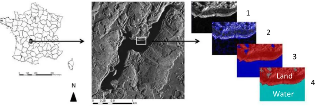
The selected site is Lake Bariousses (7.48 hm3 in volume, 0.857 km² in area, 8.7 km in perimeter, 7.4 m average depth and 22.5 m maximum depth), a stream impoundment located in the central south part of France (Fig. 1).
3. Materials
Tab. 1 provides the characteristics of the imagery data. The French Company of Electricity (EDF) provided field data consisting of punctual water surface altitude measurements encompassing imagery dates (October to November 2013).
Table 1. Characteristics of the optical and radar imagery obtained over the study site. HH and VV refer to the polarization (i.e. transmitted and received electromagnetic waves) of radar images.
4. Methods
Our hypothesis was that, in the absence of modifications in the bathymetry and perimeter of the reservoir (due to sand extraction, for example), water surface altitude fluctuations (i.e. the vertical dimension, acquired in the field) are correlated to water surface area fluctuations (i.e. the horizontal dimensions, extracted from imagery).
Attempts to extract the total water surface area from the single band, speckle filtered radar images were abandoned, however, given the difficulty in discriminating water from land in border areas affected by radar shadows. Instead, a spatial subset of mildly sloping and unencumbered littoral zone was selected (Fig.1). A simple GEOBIA with a single segmentation level followed by one or two classifications based on threshold values and/or contextual information was then adopted. For Pléiades images, all five bands were used for segmentation and threshold values for a single classification step were based on the Normalized Water Difference Index (NWDI) (Gao, 1996). For radar images, thresholds were set on the mean of the signal amplitude for the first classification. Objects from the initial class water were then merged. A second classification within this class was then applied by defining a threshold of total area in pixels (the water object actually corresponding to the lake is invariably much bigger than misclassified water objects scattered on land). Figure 1 gives an illustration of this GEOBIA of a radar image. Validation of the unsupervised classification was conducted by comparing results to those obtained through manual photo interpretation.
A linear regression model was sufficient to relate the water surface area of the spatial subset to water surface altitude. Root mean square error (RMSE) and r² values were calculated to
Imagery Bands Spatial resolution Quantity
Pléiades
4 multispectral (blue, green, red and Near Infrared) 2 m
4
1 panchromatic 0.5 m
Cosmo Skymed 1 HH (horizontal horizontal) 0.5 m 5
Figure 1. Study site Lake Bariousses (45.556° latitude and 1.813° longitude) and the steps of the GEOBIA applied in this study. 1: spatial subset (white rectangle), 2: segmentation, 3: first classification, 4: second classification.
Refer to text for details. Image: Cosmo Skymed (09/10/2013).
5. Results
Table 2 provides the results of the validation exercise, while figure 2 shows the linear regression model and a comparison between the imagery derived and field water surface altitude points. The R² value for the regression model is equal to 0.965 and RMSE equals 0.42 m. Field surface water altitude ranged from 507.25 to 513.19 m (5.94 m difference).
Figure 2. A: Observed water surface altitude from the field versus spatial subset water surface area from imagery. The solid black line represents the linear regression. B: Water level fluctuation time series estimated
from punctual field data and water surface altitude points derived from imagery. CS: Cosmo Skymed, TX: TerraSAR X, PL: Pléiades. Numbers following image ID in A are dates (all from 2013).
1 2 3 4 Water Land A B
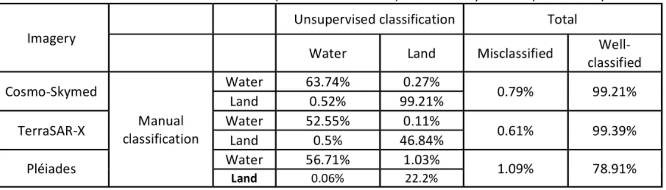
Table 2. Simplified error confusion matrix comparing the percentage of misclassified and well classified land and water surface areas. Manual classification (considered as truth) was made by manual photo interpretation.
Imagery
Unsupervised classification Total Water Land Misclassified Well
classified Cosmo Skymed Manual classification Water 63.74% 0.27% 0.79% 99.21% Land 0.52% 99.21% TerraSAR X Water 52.55% 0.11% 0.61% 99.39% Land 0.5% 46.84% Pléiades Water 56.71% 1.03% 1.09% 78.91% Land 0.06% 22.2% 6. Discussion
Results clearly demonstrate that a GEOBIA using very high spatial and temporal radar and optical imagery is suitable for tracking water level fluctuations at a fine scale. The hypothesis of a strong relationship between water surface altitude and water surface area is also validated. However, such a relationship is dependent on bathymetry and will not necessarily be linear in every case (e.g. steep profiles). And even though field data is required to derive the regression, results are sufficiently robust over Lake Bariousses to allow application of the linear relationship to future images with no coinciding field data, provided that no major changes in the bathymetry and perimeter of the reservoir occur and that water fluctuation levels remain within the range of values used to derive the regression. Analysis of altimetry data from previous years (not shown) suggests this is indeed the case for Lake Bariousses. For any given lake, altimetry field data might hence only be necessary for a limited albeit sufficient period of time to robustly establish the relationship between water surface altitude and water surface area. However, the methodology developed here also requires the presence of a mildly sloping and unencumbered littoral zone along the perimeter of the waterbody, which obviously limits its application. This could be overcome by developing a method to extract total water surface area (by using multi band radar imagery, for instance, so as to avoid radar shadows) instead of only focusing on a spatial subset.
Finally, in the absence of field water surface level data, the detailed characterization of bathymetry, either over a spatial subset or the entire waterbody, might work as a substitute. This would conceivably require less costly and time consuming fieldwork, particularly in the case of natural lakes for which field water altimetry data is not readily available. Other methods based on altimetry remote sensing data should also be considered.
Acknowledgements
We thank the French Company of Electricity (EDF) for providing field data and the GEOSUD and RTU CNES programs for supplying the imagery.
References
Blaschke T., Hay G.J., Kelly M., Lang S., Hofmann P., Addink E., Queiroz Feitosa R., van der Meer F., van der Werff H., van Coillie F., Tiede D., 2014, Geographic Object Based Image Analysis Towards a new paradigm. ISPRS Journal of Photogrammetry and Remote Sensing, Volume 87: 180 191.
Gao B.C., 1996, NDWI A normalized difference water index for remote sensing of vegetation liquid water from space. Remote Sensing of Environment, Volume 58, Issue 3: 257 266.
Kolding J., van Zwieten P.A.M., 2012, Relative lake level fluctuations and their influence on productivity and resilience in tropical lakes and reservoirs. Fisheries Research, Volume 115 116: 99 109.
Zhao D., Jiang H., Cai Y., An S., 2012, Artificial Regulation of Water Level and Its Effect on Aquatic Macrophyte Distribution in Taihu Lake. PLoS ONE, Volume 7, Issue 9: 1 10.