HAL Id: hal-00297445
https://hal.archives-ouvertes.fr/hal-00297445
Submitted on 6 Dec 2007
HAL is a multi-disciplinary open access
archive for the deposit and dissemination of
sci-entific research documents, whether they are
pub-lished or not. The documents may come from
teaching and research institutions in France or
abroad, or from public or private research centers.
L’archive ouverte pluridisciplinaire HAL, est
destinée au dépôt et à la diffusion de documents
scientifiques de niveau recherche, publiés ou non,
émanant des établissements d’enseignement et de
recherche français ou étrangers, des laboratoires
publics ou privés.
WaterNet: the NASA Water Cycle Solutions Network
P. Houser, D. Matthews, M. Brilly
To cite this version:
P. Houser, D. Matthews, M. Brilly. WaterNet: the NASA Water Cycle Solutions Network. Advances
in Science and Research, Copernicus Publications, 2007, 1, pp.23-26. �hal-00297445�
www.adv-sci-res.net/1/23/2007/
©Author(s) 2007. This work is licensed under a Creative Commons License.
Science and
Research
WaterNet: the NASA Water Cycle Solutions Network
P. Houser1, D. Matthews2, and M. Brilly3
1Center for Research on Environment and Water & George Mason University, Calverton, MD 20705, USA
2Hydromet DSS, LLC, Silverthorne, CO 80498-1848, USA
3FGG University of Ljubljana, Slovenia
Received: 10 February 2007 – Revised: 29 March 2007 – Accepted: 14 April 2007 – Published: 6 December 2007
Abstract. This paper provides an over view of a new international network of researchers, stakeholders, and end-users of remote sensing tools that will benefit the water resources management community. It discusses the concept of solutions networks focusing on the WaterNet and it invites EGU teams to join the in the initial stages of our WaterNet network. The NASA Water cycle Solutions Network’s goal is to improve and optimize the sustained ability of water cycle researchers, stakeholders, organizations and networks to interact, identify, harness, and extend NASA research results to augment decision support tools and meet national and interna-tional needs. This paper seeks to invite EU scientific teams and water resource management teams to join our WaterNet Solutions Network.
1 Background and plan
Earth is a unique, living planet due to the abundance and vig-orous cycling of water throughout the global environment. Water is essential to life and directly impacts and constrains society’s welfare, progress, and sustainable growth, and is continuously being transformed by climate change, erosion, pollution, and engineering practices. The water cycle is a critical resource for industry, agriculture, natural ecosystems, fisheries, aquaculture, hydroelectric power, recreation, and water supply, and is central to drought, flood, transportation-aviation, and disease hazards. It is therefore a national prior-ity to use advancements in scientific observations and knowl-edge to develop solutions to the water challenges faced by society. NASA’s unique role is to use its view from space to improve water and energy cycle monitoring and prediction. NASA has collected substantial water cycle information and knowledge that must be transitioned to develop solutions for all twelve National Priority Application (NPA) areas. NASA cannot achieve this goal alone – it must establish collabora-tions and interoperability with existing networks and nodes of research organizations, operational agencies, science com-munities, and private industry.
Therefore, we are developing WaterNet: The NASA Water Cycle Solutions Network, whose goal is to improve and op-timize the sustained ability of water cycle researchers, stake-holders, organizations and networks to interact, identify,
har-Correspondence to: P. Houser
ness, and extend NASA research results to augment decision support tools and meet national needs. We will develop Wa-terNet by engaging relevant NASA water cycle research re-sources and community-of-practice organizations to develop what we term an “actionable database” that can be used to communicate and connect NASA Water cycle research Re-sults (NWRs) towards the improvement of water-related De-cision Support Tools (DSTs). An actionable database in-cludes enough sufficient knowledge about its nodes and their heritage so that connections between these nodes are iden-tifiable and robust. Recognizing the many existing highly valuable water-related science and application networks in the US and EU, we will focus the balance of our efforts on enabling their interoperability in a solutions network con-text. We will initially focus on identification, collection, and analysis of the two end points, these being the NWRs and water related DSTs. We will then develop strategies to connect these two end points via innovative communi-cation strategies, improved user access to NASA resources, improved water cycle research community appreciation for DST requirements, and improved identification of pathways for progress. Finally, we will develop relevant benchmark-ing and metrics, to understand the network’s characteristics, to optimize its performance, and to establish sustainability. Figure 1 shows the NASA solutions approach. The WaterNet will deliver numerous pre-evaluation reports that will iden-tify the pathways for improving the collective ability of the water cycle community to routinely harness NWRs that ad-dress crosscutting water cycle challenges.
24 P. Houser et al.: WaterNet: the NASA Water Cycle Solutions Network
Crosscutting Solutions “Process Flow”
Figure 1. Applied Science Systems Integration Engineering Environment.
Figure 1.Applied Science Systems Integration Engineering Environment.
Houser-Matthews, February 9, 07 , Page 12
P ar tne rs hip A re as
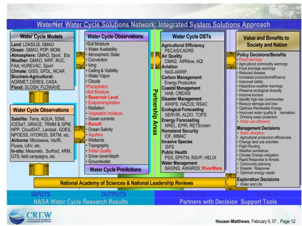
WaterNet Water Cycle Solutions Network: Integrated System Solutions Approach
INPUTS OUTPUTS
National Academy of Sciences & National Leadership Reviews Water Cycle Observations
Satellite: Terra, AQUA, SSMI,
ICESaT, GRACE, TRMM & GPM, NPP, CloudSAT, Landsat , GOES, NPOESS, HYDROS, SRTM, etc.
Airborne: Microwave, Vis/IR,
Fluxes, UAV, etc.
In-situ: Mesonets , Surfrad, ARM,
GTS, field campaigns, etc
Water Cycle Models
Land: LDAS/LIS, GMAO Ocean: GMAO, POP; MOM; Atmosphere: GMAO, Sport, Eta Weather: GMAO, WRF, RUC,
FAA; HUREVAC, Sport
Climate: GISS, GFDL, NCAR Biochem-Agricultural:
AGRMET,CERES, CASA
Flood: SLOSH; FLDWAVE
Water Cycle Observations
•Soil Moisture • Water Availability • Atmospheric State • Convection • Icing • Ceiling & Visibility • Water Vapor • Clouds •Precipitation •Soil Moisture • Reservoir Level • Evapotranspiration • Radiation • Vegetation moisture • Ocean currents • Runoff • Ocean Salinity • Aquifers • Wetlands • Topography • Water Quality • Snow cover/depth • Groundwater
Water Cycle Predictions
Water Cycle DSTs
Agricultural Efficiency
PECAS/CADRE
Air Quality
CMAQ, AIRNow, AQI
Aviation NAS-AWRP, Carbon Management Energy Production Coastal Management HAB; CREWS Disaster Management
AWIPS; HAZUS; RSAC
Ecological Forecasting
SERVIR, ALDO, TOPS
Energy Forecasting
NREL, EPRI, RETScreen
Homeland Security IOF, IMMAC Invasive Species ISFS Public Health PSS; EPHTN; RSVP; HELIX Water Management
BASINS; AWARDS; RiverWare
Value and Benefits to Society and Nation
Policy Decisions/Benefits
• Flood warnings
• Agricultural commodity warnings • Food shortage warnings • Reduced disease • Increased production/efficiency • Improved safety • Hazardous weather warnings • Preserve ecological diversity • Improve tourism • Identify high-risk communities • Reduce damage and loss • Optimize Renewable Energy • Improved water quality & recreation • Drinking water protection • Water use efficiency
Management Decisions
• Water allocation
• Agricultural production efficiencies • Change land use activities • Flight Routing • Weather avoidance • Climate Change mitigation • Rapid Response to threats • Community planning • Disaster Response • Optimize energy needs
Exploration Decisions
• Water and Life
OUTCOMES IMPACTS NASA Water Cycle Research Results Partners with Decision Support Tools
Water Cycle Models
Water Cycle Observations
Water Cycle Predictions
Water Cycle Observations Water Cycle DSTs
Figure 2. the WaterNet Water Cycle Solutions Network approach to integrated system solutions from observations
Figure 2. The WaterNet Water Cycle Solutions Network approach to integrated system solutions from observations and models to models, and predictions into decision support tools (DSTs) that yield value and benefits to society – a network between research and end-users with DSTs.
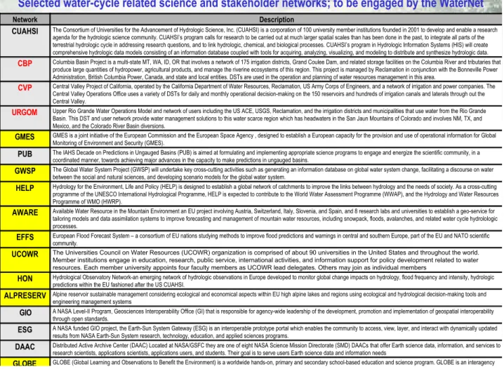
Table 1.Selected water-cycle related science and stakeholder networks to be engage by WaterNet for solutions networks.
Houser-Matthews, February 9, 07 , Page 15
GLOBE (Global Learning and Observations to Benefit the Environment) is a worldwide hands-on, primary and secondary school-based education and science program. GLOBE is an interagency
GLOBE
Distributed Active Archive Center (DAAC) Located at NASA/GSFC they are one of eight NASA Science Mission Directorate (SMD) DAACs that offer Earth science data, information, and services to research scientists, applications scientists, applications users, and students. Their goal is to serve users Earth science data and information needs
DAAC
A NASA funded GIO project, the Earth-Sun System Gateway (ESG) is an interoperable prototype portal which enables the community to access, view, layer, and interact with dynamically updated results from NASA Earth-Sun System research, technology, education, and applied sciences programs.
ESG
A NASA Level-II Program, Geosciences Interoperability Office (GI) that is responsible for agency-wide leadership of the development, promotion and implementation of geospatial interoperability through open standards.
GIO
Alpine reservoir sustainable management considering ecological and economical aspects within EU high alpine lakes and regions using ecological and hydrological decision-making tools and engineering management systems
ALPRESERV
Hydrological Observatory Network-an emerging network of hydrologic observations in Europe developed to monitor global change impacts on hydrology, flood frequency and intensity, hydrologic predictions within the EU fashioned after the US CUAHSI.
HON
The Universities Council on Water Resources (UCOWR) organization is comprised of about 90 universities in the United States and throughout the world. Member institutions engage in education, research, public service, international activities, and information support for policy development related to water resources. Each member university appoints four faculty members as UCOWR lead delegates. Others may join as individual members
UCOWR
European Flood Forecast System – a consortium of EU nations studying methods to improve flood predictions and warnings in central and southern Europe, part of the EU and NATO scientific community.
EFFS
Available Water Resource in the Mountain Environment an EU project involving Austria, Switzerland, Italy, Slovenia, and Spain, and 8 research labs and universities to establish a geo-service for tailoring models and data assimilation systems to improve forecasting and management of mountain water resources, including snowpack, floods, avalanches, and related water cycle hydrolologic processes.
AWARE
Hydrology for the Environment, Life and Policy (HELP) is designed to establish a global network of catchments to improve the links between hydrology and the needs of society. As a cross-cutting programme of the UNESCO International Hydrological Programme, HELP is expected to contribute to the World Water Assessment Programme (WWAP), and the Hydrology and Water Resources Programme of WMO (HWRP).
HELP
The Global Water System Project (GWSP) will undertake key cross-cutting activities such as generating an information database on global water system change, facilitating a discourse on water between the social and natural sciences, and developing scenario models for the global water system.
GWSP
The IAHS Decade on Predictions in Ungauged Basins (PUB) is aimed at formulating and implementing appropriate science programs to engage and energize the scientific community, in a coordinated manner, towards achieving major advances in the capacity to make predictions in ungauged basins.
PUB
GMES is a joint initiative of the European Commission and the European Space Agency , designed to establish a European capacity for the provision and use of operational information for Global Monitoring of Environment and Security (GMES).
GMES
Upper Rio Grande Water Operations Model and network of users including the US ACE, USGS, Reclamation, and the irrigation districts and municipalities that use water from the Rio Grande Basin. This DST and user network provide water management solutions to this water scarce region which has headwaters in the San Jaun Mountains of Colorado and involves NM, TX, and Mexico, and the Colorado River Basin diversions.
URGOM
Central Valley Project of California, operated by the California Department of Water Resources, Reclamation, US Army Corps of Engineers, and a network of irrigation and power companies. The Central Valley Operations Office uses a variety of DSTs for daily and monthly operational decision-making on the 150 reservoirs and hundreds of irrigation canals and laterals through out the Central Valley.
CVP
Columbia Basin Project is a multi-state MT, WA, ID, OR that involves a network of 175 irrigation districts, Grand Coulee Dam, and related storage facilities on the Columbia River and tributaries that produce large quantities of hydropower, agricultural products, and manage the riverine ecosystems of this region. This project is managed by Reclamation in conjunction with the Bonneville Power Administration, British Columbia Power, Canada, and state and local entities. DSTs are used in the operation and planning of water resources management in this area.
CBP
The Consortium of Universities for the Advancement of Hydrologic Science, Inc. (CUAHSI) is a corporation of 100 university member institutions founded in 2001 to develop and enable a research agenda for the hydrologic science community. CUAHSI’s program calls for research to be carried out at much larger spatial scales than has been done in the past, to integrate all parts of the terrestrial hydrologic cycle in addressing research questions, and to link hydrologic, chemical, and biological processes. CUAHSI’s program in Hydrologic Information Systems (HIS) will create comprehensive hydrologic data models consisting of an information database coupled with tools for acquiring, analyzing, visualizing, and modeling to distribute and synthesize hydrologic data.
CUAHSI
Description Network
Selected water-cycle related science and stakeholder networks; to be engaged by the WaterNet
Table 1. Selected water-cycle related science and stakeholder networks to be engage by WaterNet for
solutions networks.
Our team will develop WaterNet by engaging relevant NASA water cycle research resources and community-of-practice organizations, to develop what we term an “action-able database” that can be used to communicate and connect NASA Water cycle research Results (NWRs) towards the im-provement of water-related Decision Support Tools (DSTs). An actionable database includes enough sufficient knowl-edge about its nodes and their heritage so that connections between these nodes are identifiable and robust. Recognizing the many existing highly valuable water-related science and application networks, we will focus the balance of our efforts on enabling their interoperability in a solutions network con-text. We will initially focus on identification, collection, and analysis of the two end points, these being the NWRs and wa-ter related DSTs. We will then develop strategies to connect these two end points via innovative communication strate-gies, improved user access to NASA resources, improved water cycle research community appreciation for DST re-quirements, improved policymaker, management and stake-holder knowledge of NASA research and application
prod-ucts, and improved identification of pathways for progress. Finally, we will develop relevant benchmarking and metrics, to understand the network’s characteristics, to optimize its performance, and to establish sustainability. The WaterNet will deliver numerous pre-evaluation reports that will iden-tify the pathways for improving the collective ability of the water cycle community to routinely harness NWRs that ad-dress crosscutting water cycle challenges. Figure 2 shows the approach for integrating key elements.
Our tightly-knit team is composed of leading experts in NASA water cycle science, the water sector user community, and organizational connections and communications design and optimization. The team represents a strategically placed set of national and international organizations that will part-ner to harness NWRs to characterize and improve networks that sustain NPA solutions. Already established partnerships represent a cross-section of individual and networked NWRs and DSTs from government, private, and academic domains, that will enable us to quickly establish an operational so-lutions network, entrain more partner nodes and networks,
26 P. Houser et al.: WaterNet: the NASA Water Cycle Solutions Network and move WaterNet toward self-sustainability. EU projects
like AWARE, GEOSS, GMES and the Flood Forecasting Re-search projects are potential projects that may directly benefit from this WaterNet networking. Table 1 shows the existing science and stakeholder networks to be engaged by Water-Net.
2 Summary and conclusion
WaterNet is a newly emerging network of water and en-ergy cycle researchers and end-user stakeholders and water managers designed to improve the water resource, energy, and disaster management decisions by demonstrating value added from research. It seeks new partners from the EMS and EGU research and decision-making community. If inter-ested please contact [email protected].
Edited by: M. Brilly Reviewed by: M. Mikoˇs
References
Relevant web pages:
CUAHSI – http://www.cuahsi.org
(The Consortium of Universities for the Advancement of Hydro-logic Science, Inc.).
CBP – http://www.usbr.gov/dataweb/html/columbia.html (Columbia Basin Project).
CVP – http://www.usbr.gov/dataweb/html/cvp.html (Central VAlley Project of California).
URGOM – http://www.spa.usace.army.mil/urgwom/default.asp (Upper Rio Grande Water Operators Model).
GMES – http://www.gmes.info/
(Global Monitoring of Environment and Security). PUB – http://pub.iwmi.org/UI/Content/Default.aspx?PGID=0
(Predictions in Ungauged Basins). GWSP – http://www.gwsp.org/
(Global Water System Project).
HELP – http://portal.unesco.org/sc nat/ev.php?URL ID=1205\
&URL DO=DO TOPIC\&URL SECTION=201 (Hydrology for the Environment, Life and Policy). AWARE – http://www.aware-eu.info/
(Available Water Resource in the Mountain Environment). EFFS – http://effs.wldelft.nl/index.htm
(European Flood Forecast System). UCOWR – http://www.ucowr.siu.edu/
(Universities Council on Water Resources). ALPRESERV – http://www.alpreserv.eu/
(Alpine reservoir sustainable management). GIO – http://gio.gsfc.nasa.gov/
(Geosciences Interoperability Office).. ESG – http://esg.gsfc.nasa.gov/web/guest/home
(Earth-Sun System Gateway). DAAC – http://edcdaac.usgs.gov/
(Distributed Active Archive Center).
GLOBE – http://www.globe.gov/globe flash.html
(Global Learning and Observatories to Benefit the Environment). EOS – http://gcmd.nasa.gov/records/EOSDIS-ECHO.html
(ClearingHOuse ECHO).