HAL Id: hal-01676901
https://hal.archives-ouvertes.fr/hal-01676901
Submitted on 1 Feb 2019HAL is a multi-disciplinary open access
archive for the deposit and dissemination of sci-entific research documents, whether they are pub-lished or not. The documents may come from
L’archive ouverte pluridisciplinaire HAL, est destinée au dépôt et à la diffusion de documents scientifiques de niveau recherche, publiés ou non, émanant des établissements d’enseignement et de
Large Eighteenth–Nineteenth Century Earthquakes in
Western Gulf of Corinth with Reappraised Size and
Location
Paola Albini, Andrea Rovida, Oona Scotti, Hélène Lyon-Caen
To cite this version:
Paola Albini, Andrea Rovida, Oona Scotti, Hélène Lyon-Caen. Large Eighteenth–Nineteenth Cen-tury Earthquakes in Western Gulf of Corinth with Reappraised Size and Location. Bulletin of the Seismological Society of America, Seismological Society of America, 2017, �10.1785/0120160181�. �hal-01676901�
Large 18
th-19
thcenturies earthquakes in Western Gulf of Corinth
with reappraised size and location
Paola Albini (1), Andrea Rovida (1), Oona Scotti (2), Hélène Lyon-Caen (3)
(1) Istituto Nazionale di Geofisica e Vulcanologia, Sezione di Milano, Milano, Italy Corresponding author: paola.albini@ingv.it
(2) Institut de Radioprotection et de Sûreté Nucléaire, Bureau des Risques Sismiques pour la Sûreté des Installations, Fontenay aux Roses, France
(3) Laboratoire de Géologie, Ecole normale supérieure/CNRS UMR 8538, PSL Research University, Paris, France
Abstract. The area of the Western Gulf of Corinth around the city of Aigio (Achaea, NW
Peloponnese, Greece) represents an international pilot site for continuous monitoring and multidisciplinary research on earthquake processes. In the framework of the ANR-SISCOR Corinth Rift Laboratory (CRL) project (2011-2014), a thorough reappraisal of the five largest (M>6) 18th-19th century earthquakes was performed, namely those of 14 May 1748, 23 August 1817, 26 December 1861, 9 September 1888, and 25 August 1889. Written observations of earthquake effects were looked into in their original version and language, and placed in the context from which they originated, to avoid the translations and digests on which previous seismological studies had relied upon. Earthquake records were traced for 108 different localities, and 143 macroseismic intensities in EMS98 have been assigned. Earthquake-related geological phenomena have been identified and carefully mapped, to be used as a further constrain of the location and magnitude of the associated earthquakes. Finally, new parameters for the studied earthquakes have been assessed with two separate and independent strategies, in order to quantify epistemic uncertainties. In conclusion, the 1748, 1817, and 1888 earthquakes were located in the area of Aigio, the 1861 earthquake is reckoned to be the largest of the area, with an epicentral location at sea, while the 1889 earthquake has been re-located to the northwest in mainland Greece, well outside the Gulf of Corinth.
Introduction
The Corinth rift, situated between western mainland Greece and Peloponnese, is among the most tectonically active areas in the Euro-Mediterranean region, as the result of the large-scale back-arc extension of the Hellenic Trench, and the westward propagation of the North Anatolian Fault (e.g. Armijo et al., 1996; Jolivet, 2001; Reilinger et al., 2010).
North-dipping normal faults bounding the southern edge of the Gulf and offshore normal and strike-slip faults (e.g. Armijo et al., 1996; Bell et al., 2009; Beckers et al., 2015) accommodate most of the deformation of the area.
With five earthquakes of magnitude greater than 5.8 in the last 35 years, 1 to 1.5 cm/year of north–south extension, frequent seismic swarms, and destructive earthquakes in the past centuries (e.g. Briole et al., 2000; Papazachos and Papazachou, 2003; Papazachos et al., 2010; Stucchi et al., 2013; Bernard et al., 2006), the rift has long been identified as a site of major importance for earthquake studies in Europe. In 2000, the Corinth Rift Laboratory (CRL) identified the western part of the Gulf of Corinth as an international pilot site for continuous monitoring and multidisciplinary research on earthquake processes (Cornet et al., 2004; Bernard et al., 2006; Corinth Rift Laboratory website), and the project ANR-SISCOR CRL (2011-2014) has focused on the region of Aigio, in today regional unit of Achaea, NW Peloponnese (Figure 1). Adopting a multiscale approach to improve the understanding of the most recent tectonic evolution, it was ascertained that the Corinth fault system is continuously evolving in space and time at geological time scales (Nixon et al., 2016; Beckers et al., 2015; Hemelsdaël and Ford, 2016, and reference therein).
In this multidisciplinary project, there has been space for a specific review of the knowledge of earthquakes in the pre-instrumental period, with the purpose of gathering information to assess macroseismic data, and reappraise the earthquake parameters, eventually. Modern studies and regional seismic catalogues (e.g. Papazachos and Papazachos, 2003) enlist damaging earthquakes that targeted Aigio and its surroundings since Antiquity. This is the case of the famous 373 BCE earthquake, which destroyed the coastal town of Helice and the inland town of Boura, both located close to Aigio(e.g.
Ambraseys, 2009); the ca 23 AD earthquake, which damaged the “Peloponnesian port of Aegeum (Aigio)” (e.g. Ambraseys, 2009); the controversial 551 AD cluster of earthquakes, one of which was located “in the western part of the Gulf of Corinth and in Achaea” by Ambraseys (2009).
For the period 1000-2010 (Figure 1), the seismicity is described up to 1899 by the European-wide catalogue SHEEC (Stucchi et al., 2013), and Papazachos et al. (2010) for the period 1900-2010. Between 1000-1899, the above mentioned catalogues list five earthquakes only, with magnitude values ranging from Mw 6.3 to 6.9, located in the western Gulf of Corinth: 14 May 1748, 23 August 1817, 26 December 1861, 9 September 1888, and 25 August 1889 (Figure 1).
A preliminary overview of previous studies has shown that very few Intensity Data Points (IDPs) were available, even for such indisputably large earthquakes. To reappraise size and location with methods processing macroseismic data, these five earthquakes were
investigated ex novo, to assign robust intensity values at as many different places as possible. Finally, for each earthquake epicentral location and magnitude were estimated, based on the exploration of two separate strategies that allow quantifying epistemic uncertainties when processing macroseismic intensity data.
Collecting and processing macroseismic intensity data
From observations to earthquake records
Macroseismic intensity data are widely recognized as the “best available information from which to constrain the magnitude” of pre-instrumental earthquakes (e.g. Hough and Martin, 2015). Both the definition of macroseismic intensity, in this study according to EMS98 (Grünthal, 1998), and the procedures to obtain reliable intensity values have been the object
of quite a number of contributions (e.g. Musson and Cecić, 2002). What is rarely made available in literature, is the thorough, painstaking process required to i) identify the written sources potentially containing descriptive data useful for seismological purposes, and retrieve them, ii) build up of a set of well-distributed-in-space earthquake records (what Musson and Cecić, 2002, shortly define “all available information”), and eventually iii) have a basic knowledge to place descriptions of earthquake effects in their own
geographical and historical context, in the light of the language, culture and scope at the very origin of the written testimonies.
While these aspects are detailed in the sections dealing with individual earthquakes, the following notes pinpoint historical, historiographical, geographical, and seismological issues, which were inextricably connected with the scientific process carried out to reappraise the five earthquakes of study.
Calendar and time measure - The Calendar in use in Greece in 18th and 19th centuries
was the Julian calendar, defined as Old Style (O.S.) when it was dismissed and substituted with the Gregorian calendar, or New Style (N.S.). The change of calendar had started in western European countries in 1582, but the times of its adoption differ from country to country, and Greece passed to the Gregorian calendar in 1953. Thus, the dates of 19th century Greek newspaper issues are expressed in O.S. in text, figures and tables, including those in the electronic supplement to this article (Tables S5, S6, S7, S8). Dates in both styles are given when introducing the description of each earthquake (e.g.: 14 December O.S./26 December N.S. 1861), and for the press in the reference list, only. The Italian usage of measuring time, with each day starting at sunset, was employed in many Mediterranean countries, and especially in territories ruled by or linked with Italian states, through all 18th
century. From independence onwards (1821), Greece used the French style, spread during the Napoleonic period, with each day starting at midnight and divided into two periods, a.m. and p.m. In the contemporary sources, the time of the 1748 earthquake is given only according to the Italian usage, that for the 1817 event, a moment of transition, is given according to both usages, and from the 1861 event onwards the time of the shock is according to the French or modern style only.
Settlements – After the earthquake observations have been attributed to one and the same
earthquake, starts the process of sorting the data by place. To avoid assigning intensity either “to a single street” or “to a whole county” (Musson and Cecić, 2002), one has to correctly locate and identify the affected settlements, in relation with their actual distribution and location when the earthquake happened. In addition to modern
cartography, were used for Peloponnese “the ‘scientifically-derived’ map” (Witmore, 2013) as drawn by Bory de St. Vincent's "Expédition Scientifique de Morée" (Carte de la Morée, 1832), and for Greece the “General-Karte des Königreichs Griechenland” compiled by I. Kokkidis and H. Kiepert for the K.u.K. Militärgeographische Institut, Vienna (General-Karte, 1884-1885).
Place names have changed, many times, and in correlation with the domination and official language of the rulers of either the Achaea region or Peloponnese. Present day Peloponnese was called “Morea” (or “Mora”) under the succeeding Latin (Frankish and Byzantine, 13th century to 1460), and Ottoman (1460–1687, and 1715-1820) rules, and also “Romania” during the second Venetian rule (1685-1715). The town of Aigio was known by the name of Vostitsa, with the main variants Vostizza, Vostissa, for centuries, and both names were used well into the 19th century. Different place names were used simultaneously and
indifferently, with the dismissed ones simply disappearing from the latest maps. Tables S1, S3, S5, S6, S7 of the electronic supplement to this article contain both the place names as quoted and those in use today.
Sources of information - Types of sources could not but vary in correspondence to
changes of local governments and the passing of time. Administrative documentation was only partially considered in the framework of this study, with the exception of the
documentary sources for the second Ottoman ruling period (1715 to 1820), already studied and accounted for in previous studies (Ambraseys and Finkel, 1999; Ambraseys and Jackson, 1997; Ambraseys, 2009 and 2014). Here follows a list of the main types of sources used, and the related period of production:
• Travelogues, 18th and 19th century
• Early cadasters, 18th century, and Maps, 19th century
• Commercial and diplomatic Consuls’ reports, 18th and 19th century • Periodical press and private correspondence, 18th and 19th century • Local histories, late 19th and early 20th century
• Seismological compilations, mid-19th century onwards.
Language and location of surviving sources have significantly marked this investigation, too. This is due partly to the variety of sources mentioned above and partly to the area of study being a crossroad of cultures and languages, especially in late 18th and 19th
centuries. Although in the end the predominant language was of course Greek, in order of relevance the list comprises German, English, Italian, and French.
As for their location, the greatest part of the original texts were retrieved through the internet, which is surely the main “repository” accessed along the years this study was
carried through. The British Library, London, and The National Archives, Kew Gardens (UK), the “Centre des Archives diplomatiques de La Courneuve”, Paris (France), the “Archivio di Stato” (State Archives) of Venice, and “Biblioteca Comunale” (Municipal Library), Piacenza (Italy) were visited in person.
What sets of sources were looked into, what were the difficulties related to “translation” vs “abridgment”, and what types were eventually used for the interpretation of each individual earthquake, will be explained in the following three sections, in which the five studied earthquakes have been grouped.
Macroseismic intensities and earthquake related phenomena
Once the observations have been gathered, they have to be put in the context of their time and place of production, to identify which sources have a common origin, also in case of no explicit cross-reference, and which are the unquestionably independent items. To this end, each source of information had to be retrieved in its full, original version, regardless of the fact that previous studies had i)already used it, or ii) published some fragments, translated from any language into English, or iii) supplied a summary of its seismological contents. In the words of Musson and Cecić (2002), each set of descriptions has to be checked against “the intensity scale to determine which description of those for the various intensity degrees best fits the sum of the data for the particular place under consideration. The key concept here is coherence. It is not helpful to get lost in a pursuit of detail of individual diagnostics; the correct assignment is the one that best expresses the generality of the observations”. This specific part of intensity assignment was reckoned to be best described in relation with the peculiarities of each of the five earthquakes occurred in the 140 years time-span here considered. With respect to each case study, it will be explained which
earthquake records were recognized to be original, “independent”, not biased, so to become those containing the relevant diagnostics, as well as supplemental information (such as how many buildings existed at the time of the earthquake, how many were affected, and by what grade of damage), needed and used to produce coherent and robust sets of macroseismic Intensity Data Points, according to the guidelines of EMS98 (Grünthal, 1998).
Quite a number of observations of earthquake-related geological phenomena were supplied by contemporary sources, and are fully described and discussed in the following. However, as strongly suggested by the EMS98 guidelines, these effects were not directly used to assign an intensity value, given both the dependence of such effects on peculiar geological environments, and the inherent difficulties in their localization with a pair of geographical co-ordinates (Grünthal, 1998). Anyway, records of earthquake-related phenomena proved to be a useful complementary tool to appreciate the extent, and the most likely location of earthquakes (e.g. see the discussion of the 1817 and 1889 events’ location), a key problem in a region where they may be located offshore.
Reappraising size and location
The above described process was the necessary, preliminary step to re-assess location and magnitude for the five studied earthquake, according to procedures making use of IDPs. Location and magnitude estimates from macroseismic data depend on the Intensity Prediction Equation (IPE) and the Intensity Measure (IM) used. IPEs depend on the regional characteristics of wave propagation and the kinematics of earthquake motion, and are thus derived with a set of events with known magnitude and consistent intensity distributions that occurred in the region of interest. Due to an insufficient number of well
by Papazachos and Papaioannou (1997), hereafter P&P97, and one developed by Gomez Capera et al. (2014).
The P&P97 IPE is derived from a set of 177 earthquakes that occurred all over Greece. It is based on the following functional form:
I = 1.258 + 1.613 Mw – 3.282 Log R - 0.003 R (1) where R is the hypocentral distance.
The IPE by Gomez Capera et al. (2014) is based on the functional form by Sibol et al. (1987):
Mi = ai + bi log2 (Ai) + ci Io2 (2)
where Ai is the area of the i-th isoseismal, and Io is the epicentral intensity. The coefficients
ai, bi and ci were derived, for each intensity class, from 36 crustal (depth between 1 and 16
km) earthquakes that occurred all over mainland Greece in the time-period 1905-2003, with instrumentally recorded magnitudes in the range 5.1 - 7.0. The dataset includes 10 earthquakes in the Gulf of Corinth.
In order to capture the epistemic uncertainty that affects not only IPEs but also the IM used for determining magnitude, two strategies are considered for the reassessment of location and magnitude of the five studied earthquakes:
1) The SISCOR strategy that uses the Bakun and Wentworth (1997) method, hereafter BW, to calculate the macroseismic magnitude based on the minimization of root mean square (rms) of a specific IPE over a grid of trial source locations. Then, it identifies the grid node for which rms is minimum as the macroseismic epicentre, and the associated magnitude value as the earthquake macroseismic magnitude. Bootstrap resampling techniques are then used to calculate 67% confidence regions for the
location (Bakun and Scotti, 2006). In this method the depth is assumed by considering the depth of instrumental seismicity and the IM used is each individual point-to-epicentre distance. The IPE published by P&P97 is selected because it has a functional form suitable for the BW method.
2) The SHEEC strategy that uses the Boxer method (Gasperini et al., 1999; 2010). In this method the trimmed mean of the coordinates of the sites in the highest intensity class(es) is first computed as the macroseismic epicentre. Then, for each intensity class, the area of a circular isoseismal with the radius equal to the mean of the intensity point-to-epicentre distances is computed and used to calculate a magnitude value with an IPE in the functional form of equation (2). The macroseismic magnitude is the trimmed mean of the magnitudes derived for each intensity class. The magnitude uncertainty corresponds to the square root of the inverse of the sum of the weights of the isoseismals used in the trimmed mean. Boxer uses the epicentral intensity to mitigate the effect of source depth (Gasperini et al., 1999). In the Boxer method, the IM used is the mean of the intensity point-to-epicentre distances. The IPE published by Gomez Capera et al. (2014) is selected because it has a functional form suitable for the Boxer method.
Both selected strategies were compared with data from the only three recent earthquakes in the Gulf of Corinth for which both macroseismic data points and instrumentally assessed parameters are available. As shown in the electronic supplement to this article (“Testing location and magnitude”, which includes Tables S9 and S10, Figures S1, S2, S3), the two strategies lead to very similar predictions, reasonably close to the instrumental estimates. Nevertheless, uncertainties in location and magnitude affect both
instrumental and macroseismic determinations, and the application of the two strategies provides a minimum uncertainty estimate.
To obtain reliable seismic parameters, for each earthquake a set of well-distributed, robust, complete, and abundant IDPs is needed. Considering that such IDPs are not available in published literature, it was essential to put them together anew, from scratch, as described in the following.
Two Aigio earthquakes: 14 May 1748 and 23 August 1817
These two earthquakes occurred during the second and last period of Ottoman rule (1715-1820), when Achaea, and all Peloponnese, was included in the “Morea Eyalet”, governed by a pasha residing first at Nafplio (Argolic Gulf), then at Tripoli (also Tripoliçe, Tripolitsa) (e.g. Magocsi, 1993). At that time, the region was certainly not a center of attention of the Ottoman administration. Although the Grand Tour’s revived interest in classical antiquity was already a tradition in mid 18th century, few were the western travelers who reached the places of origin of the classical Greek society, myths and literature, and one has to wait for the beginning of the 19th century to have the Peloponnese really back in the spotlight. This sort of centuries-old oblivion of Achaea represented a challenge with respect to potential - and likely to be accessible - sources of information on earthquakes between 1748 and 1817.
The 14 May 1748 earthquake
The Ottoman re-conquest of Peloponnese from Venice in 1715 did not result in a complete break with the past tradition of hosting diplomatic and trade consuls of the Republic of Venice, the Kingdom of France, and the United Kingdom. Consequently, it is not surprising that the most detailed description of the effects of the 1748 earthquake is contained in a long letter, written three days after the earthquake, by the Venetian trade consul Lappo, residing in Ottoman Morea, exactly at Patras (Figure 1). Lappo’s letter (Lappo, 1748) was addressed to the governor (“provveditore”) of the then Venetian-ruled island of Zakynthos (see Figure 1). Although the original document was looked for without success in the related archival series at the State Archive of Venice (ASVe, 18th cent), a rare printed copy of its full content was found at the Public Library at Piacenza, Italy (Relazione, 1748).
The letter by Lappo was reproduced in extenso and in its original language (Italian) by Issel and Agamennone (1894). They were given the handwritten letter by a “De Biasi” - De Viazis in Greek, who got hold of it in the archive of the Catholic church of San Marco at Zakynthos. The same De Viazis (1891) had already published an abridged version of Lappo’s letter in a Greek translation. Note that all previous studies, and among them Ambraseys and Jackson (1997), Ambraseys and Finkel (1999), Papazachos and Papazachou (2003), Ambraseys (2009 and 2014), relied on De Viazis’s abridged version only, to describe and estimate this earthquake.
Samples were made into diplomatic and commercial correspondence, and the coeval periodical press and travelogues were investigated, too. Although the weekly “Gazette de France” in the period between June and August 1748 published correspondences from “Constantinople”, no items on this earthquake were included. Travelers were still a few,
even less those who actually got to publish their journals. In 1766, Richard Chandler had visited Aigio, and its inhabitants had supplied him with details on the 1748 earthquake’s effects (Chandler, 1776). A well-known traveler and French consul in early 19th century Greece, François Pouqueville, in his “Voyage dans la Grèce” drew upon Chandler’s account, and partially objected to its veracity (Pouqueville, 1820). At that time, western travelers to Greece were a small, pseudo-academic circle, quoting each other, and rarely including first-hand and independent observations.
A confirmation that the coeval sources for Aigio and surroundings in mid-18th century are scarce is found in the history of the town of Aigio compiled by the historian Stavropoulos (1954). He had to glean information from Chandler (1776) and Pouqueville (1820), and for what the 1748 earthquake is concerned, Stavropoulos re-published, in a slightly revised and annotated version, the letter by consul Lappo in the shortened translation into Greek made by De Viazis (1891).
Time and effects
The date of this earthquake had to be re-adjusted with respect to current catalogues (e.g. SHEEC, Stucchi et al., 2013). The day when the earthquake happened is clearly indicated in the letter from consul Lappo as “Last Tuesday, on the 14 extant [May 1748]” (Lappo, 1748; Relazione, 1748). Correctly, Ambraseys and Jackson (1997) dated this event to the 14th of May 1748 N.S., while some following studies (Ambraseys and Finkel, 1999; Papazachos and Papazachou, 2003; Ambraseys, 2009 and 2014) have mistakenly assumed the date to be expressed in O.S. Thus, eleven days were added to transform the date into N.S., to obtain the 25th of May 1748. However, the 25th of May 1748 was a Saturday, and it does not comply with the day of the week being a Tuesday, as given by Lappo (1748). To
further confirm that the style of calendar adopted was N.S., there is the fact that the time is given as “at 21 hours”, according to the Italian usage. It corresponds to 15.30 GMT (17.30 Athens time) when translated into today’s style of time measuring.
The place where Lappo found himself at the time of the earthquake is mentioned at the beginning of the letter: “[…] there was a sensational earthquake that here in Patras, due to the Almighty’s mercy, caused little or no harm.” Then the focus moves towards Aigio: “At its start the earthquake was felt there [Aigio] as modest, and it left the panicked inhabitants enough time to get out from their homes and move in the middle of squares and widely open streets. Hereinafter, as the earth continued to shake, again and again, almost all the buildings, churches and towers ruined, with not much harm to the people, as they had taken the precaution to leave their homes at the earliest opportunity” (Lappo, 1748).
The observers’ attention was caught by the tsunami triggered by the earthquake, as can be seen in the accounts by Lappo and Chandler, which are compared in Table 1.
The plane-tree is the landmark both observers referred to, and used to give a measure of the height of the waves (Figure 2). The third wave seems to have reached the upper part of the town, well above the plane-tree that, still today, lies in the lower part, close to the coastline.
De Viazis (1891) added that some inhabitants of Patras and Aigio had to forcedly migrate to Zakynthos. This same information is quoted by Issel and Agamennone (1894), with the addition that the earthquake had been felt at Zakynthos, though very weakly.
Ambraseys (2009 and 2014) connected to this earthquake the information contained in two Ottoman documents, dated a few years after 1748, and generically mentioning damage suffered by the towns of Nafpaktos, northern coast of the Gulf of Corinth, and
Corinth, at its easternmost tip (Figure 1). These Ottoman documents do not explicitly mention the date of the earthquake, making reference to damage caused by a “former” earthquake. After a thorough consideration, and in the light of the comprehensive reappraisal of the coeval sources presented above, including the complete silence about any earthquake damage in any place other than Aigio, it was decided on not linking these two Ottoman documents to the 1748 earthquake’s effects, and consequently the places of Nafpaktos and Corinth were not included among those that were seriously affected. In conclusion, macroseismic intensity in EMS98 was assigned at three places, namely Aigio with 8 EMS98, Patras with an intensity of 5 EMS98, and Zakynthos, 2 EMS98, as shown in Table S1 in the electronic supplement to this article.
The 23 August 1817 earthquake
Sources and their accounts
Unlike the preceding case, the 23 August 1817 earthquake effects are evoked by quite a number of contemporary and near-contemporary sources, some of which were known to and used by modern studies, such as Ambraseys and Jackson (1997), Papazachos and Papazachou (2003), and Ambraseys (2009).
The most represented types of source used by previous studies of the 23 August 1817 earthquake are travelogues, and periodical press in Greek, French and English. In early 19th century, the Peloponnese (Morea) was travelled by quite a number of British and French visitors, either on diplomatic duty, such as the French consul François Pouqueville (1820), or for scientific and artistic purposes (e.g. the military geographer and British agent W.M. Leake, 1830, or the classical topographer W. Gell, 1817, travelling with the painter E. Dodwell, 1819). None of them could have experienced the earthquake in person, because
their explorations were carried out mostly before, or well before, August 1817, even if their books were published after 1817. The only exception is Fuller (1829), who visited Aigio in 1818, and was supplied with fresh memories by its same inhabitants. To complement this mostly second-hand sources of information, the search was extended to the reports of the British and French consuls in Greece, and more titles of the periodical press of that time, so that hitherto unknown, independent accounts of the 23 August 1817 earthquake were retrieved.
A comprehensive view of place and time of production of the seven independent accounts this study is based upon, together with their date and actual medium of publication is given in Figure 3 (shaded boxes), and they are:
1 & 2) two unpublished reports by the French consul in Patras, Augustin Arady (Arady, 1817a and 1817b), the first written four days and the second ten days after the earthquake, respectively;
3) a so far unknown, anonymous report in Italian, written at Aigio six days after the earthquake, appeared in the Corfu periodical Gazzetta Ionia (1817) three weeks later (Anonymous, 1817a);
4) an anonymous from Patras (Anonymous, 1817b), who dated his account sixteen days after the earthquake; this item, most likely in French, was first published in the
Journal des Débats, Paris (1817) more than two months later, then translated into English
to appear in the Morning Post, London (1817), four days later; this record has been reckoned as the most appreciated by the European and early American press of the time, and was published in several newspapers and journals in a verbatim translation into English (e.g. Morning Chronicle, 1817; Literary Gazette, 1817; American Monthly Magazine,
1818), Italian (e.g. Gazzetta Piemontese, 1817; Gazzetta di Milano, 1817; Messaggere Tirolese, 1817; Gazzetta di Mantova, 1817; Giornale della Provincia Bresciana, 1817); Dutch (e.g. Leydse Courant, 1817), German (e.g. Linzer Zeitung, 1817; Weimarische Zeitung, 1817), and Spanish (e.g. Gaceta de Madrid, 1817);
5) an anonymous from Constantinople (Anonymous, 1817c), who wrote three weeks after the earthquake, addressed his report to Hermes o Logios (1817), a newspaper in Greek language published in Vienna, to see it published two months later;
6) another anonymous from Constantinople (Anonymous, 1817d), who resumed the subject of the earthquake more than three months later, and whose item was published by the Journal des Débats (1818) and by the Gentleman’s Magazine (1818);
7) an anonymous from Constantinople (Anonymous, 1818), who sent two different accounts, dated 27 December 1817 and 8 January 1818, to Hermes o Logios (1818), where they were published together three months later.
Table S2 in the electronic supplement to this article contains the full-text description of the earthquake effects given by these seven independent sources.
Date and macroseismic effects
This earthquake occurred on a Saturday, 11 August O.S., corresponding to 23 August 1817 N.S. Time is approximately indicated between 6 and 9 a.m., as follows:
• “Le 23 aoust a 8 heures du matin” (Arady, 1817a)
• “Agli 11 (23) Agosto giorno di Sabbato a mezz’ora di giorno (alle sei ore circa antimeridiane)” (Anonymous, 1817a)
• On the 11/23 August of the past year 1817, at 9 hours, i.e. at 15 hours Italian style, a Saturday (translated from Greek; Anonymous, 1818).
As in the previous case, the accounts of the earthquake effects focused on the town of Aigio. All the testimonies agree in describing one sudden noise immediately followed by one violent shock, which lasted “one and a half minute”. This is different from what happened with the 1748 earthquake, which had been announced by foreshocks. The suddenness of this earthquake seems to be the reason for the high number of dead, on which there are at least two divergent opinions. According to three sources (Anonymous, 1817a, Arady, 1817b, Anonymous, 1817b) at Aigio 65 people died under the ruins, while they were 110 according to the anonymous from Constantinople (Anonymous, 1818).
A report from Aigio (Anonymous, 1817a) (Figure 3) is a unique source, and its vivid and accurate account of the earthquake effects in each neighborhood (“contrada”) of Aigio gives a detailed distribution of damage on the occasion of the 23 August 1817 earthquake (Table 2). The total number of buildings (694 houses, 52 shops, and 6 ovens) is very close to that of “800” given by the French consul Arady (1817b) as the number of existing buildings in Aigio. The seriously damaged buildings result to be close to 500, and this figure is in agreement with the approximation of “two thirds” given by the late report from Constantinople (Anonymous, 1818).
The available records agree also in reporting at five nearby villages a grade of damage similar to that experienced at Aigio. Two sources only (Anonymous, 1817a; Arady, 1817b) correctly spell the place name of “Cumari”, today Koumaris, while the other places have been identified as Eliki (Zevgolatio until 1917), Temeni, Rododafni, and Dimitropoulo. The earthquake was strongly felt at Patras. In all, macroseismic intensity was assessed at seven places, with the maximum value of 9 EMS98 assigned at Aigio (Figure 4, and Table S3 in the electronic supplement to this article).
There are records of a tsunami affecting both coasts of the Gulf of Corinth with strong effects at Aigio - where 18 people were drowned (Anonymous, 1818) - and Trizonia (Figure 4), where it destroyed two buildings (Anonymous, 1817a).
According to contemporary sources (see Table S2 in the electronic supplement to this article), in the harbor of Aigio, the sea level rose more than 15 cubits (Anonymous, 1817c), or 20 cubits (Anonymous, 1818), or 15 feet (Arady, 1817b; Anonymous, 1817b), which in meters correspond to 6.8 m., 9.1 m., and 11.2 m., respectively. At Aigio and surroundings, especially in the area close to the mouth of the River “Gaidouropnieti” (today Meganitas), the water reached inland a distance of 100 paces (Arady, 1817b; Anonymous, 1817b), or 50 cubits (Anonymous, 1818), corresponding to 75 meters, or 23 meters, respectively. According to Anonymous (1817a), the sea flooded the area comprised between the “wood of Longos and the monastery of Calogericò” (not marked in Figure 4). At Trizonia, the sea advanced inland for 200 paces, corresponding to ca 150 meters (Anonymous, 1817a).
The information about the tsunami reaching Galaxidi (Phocis, see also Figure 1) comes from two contributions by Christomanos (1870a and 1870b), which were not retrieved in their original version. Although accepted by previous interpretations, this unchecked record was considered not reliable enough to be associated with the 1817 earthquake.
A veritable Western Gulf of Corinth earthquake: 26 December 1861
The 26 December 1861 earthquake is included in several studies focusing on large earthquakes of the Gulf of Corinth (e.g.: Mouyaris et al., 1992; Lekkas et al., 1996; Caputo et al., 2015). Researchers’ quite uninterrupted attention was drawn by the presumed 12 to 13 km surface rupture mapped by the German astronomer Johann Friedrich Julius Schmidt
(1825-1884), who at the time of the earthquake was the Director of the Observatory of Athens. Schmidt published two maps (from now on map1 and map2, as in Figure 5), the most famous being that in color, or map2 (Schmidt, 1875). Map2 details the geomorphological features of the Aigio plain, from the mouth of the river Meganitas, roughly at Rododafni – then Mourla, to the mouth of the river Erasinos, in correspondence to the small settlement of Pounta, immediately east of Diakopto (Figure 6). Superimposed are the effects of the 1861 earthquake, according to the observations Schmidt himself made in January 1862, along routes rendered in the map with red lines. The paramount piece of this map is the “grosse Spalte”, literally the large fissure, which had opened between the "alluvial plain southeast of Aigio and the foothills to the south-west" (Schmidt, 1875). This same map was re-drawn in a simplified manner by Montessus de Ballore (1924), and in this latter version published by Richter (1958), also; all the studies referenced above include a reproduction of Schmidt’s map2.
Some authors consider the 1861 surface rupture the effect of the reactivation of the 373 B.C. Helike fault (Sebrier, 1977; Mouyaris et al., 1992; Caputo et al., 2015). Others, following de Ballore (1924), interpreted "this crack nothing more than the surface expression of a large-scale slumping and spreading of the valley material” (Richter, 1958; Antonopoulos, 1980, who also re-published the simplified map from Richter). Recently, also Ambraseys (2009) concluded that “the ground crack described by Schmidt was not of tectonic origin”.
On the contrary, the 1861 earthquake macroseismic effects have been so far less valued, although included in some studies of the historical earthquakes of the Gulf of Corinth (Ambraseys and Jackson, 1997; Ambraseys, 2009), Greece (e.g. Papazachos and
Papazachou, 2003), or the Balkan peninsula (Shebalin, 1974). These authors published either a textual description of the effects, or isoseismals, or earthquake parameters, but no estimate of macroseismic intensity values at the affected sites.
Sources and their accounts
When considering the surviving descriptions of this earthquake, the starring role is undeniably played by the writings of Julius Schmidt, who obscured all the other observers with his detailed and captivating reports, and his two maps. In Schmidt’s own words (Schmidt, 1875) his most important publications on the 1861 earthquake are five accounts, shortly described in Table 3, and referenced in “Julius Schmidt” box of Figure 5.
These five items do not include the several newspaper articles signed by Schmidt himself, as he considered them not so much relevant. He rather nailed down the comprehensive essay completed in 1874, and included in the successive editions of his “Studien über Erdbeben” (Schmidt, 1875, 1879, 1881) as the ultimate study on the 26 December 1861 earthquake: “This is the definitive report on which I have been working in the thirteen years since the earthquake” (Schmidt, 1875). He used his handwritten material, essentially what he had collected on the occasion of the two surveys of the affected area he had done between 31 December 1861 and 29 January 1862, together with the data from other scientists’ essays.
In pinpointing his last account as definitive, Schmidt diverted the attention of those who studied this earthquake after him from the other contemporary sources, as well as the several later publications, to the point that he overshadowed his own other essays, and mainly his first report in Greek (Schmidt, 1862b). The latter was ready to be published in September 1862, with the first map of the effects in the plain of Aigio, but had to wait until
1867 to be published, due to the political turmoil Greece was living in those days. In other words, Schmidt restricted the access to a comprehensive description of the 26 December 1861 earthquake to those able to read German, and focused the scientists’ attention on its most easily accessible part, the self-explaining map of the “grosse Spalte” in the plain of Aigio (Figure 6).
Differences and incoherencies among the data contained in Schmidt’s reports become evident when comparing the digests he included in each of them. Table S4 in the electronic supplement to this article supplies their full texts, and shows that none of them actually describes the earthquake in its entirety. This holds especially from the perspective of acquiring an overall distribution of macroseismic data. On the contrary, excluding the limited area of the plain of Aigio, as in map1 and map2, the scenario of the 1861 earthquake drawn by Schmidt results in a narrow and sometimes blurred vision.
To change this point of view, and go beyond the so far “untouchable” Schmidt’s description, earthquake observations hitherto not considered by previous studies have been added by means of a set of primary sources, and fully reinterpreted. The most substantial contribution comes from an increased set of Greek newspapers, shown in Figure 5 in the box “Local newspapers”. Six of them, namely Aion (1861, 1862), Anegersis (1861, 1862),
Avgi (1861a-h; 1862), Elpis (1862), Merimna (1861), and Phos (1861a-c; 1862a-b) were
published in Athens. Printed in Tripoli (Arcadia, Peloponnese) were Arkadia (1861a-b, 1862a-b), and Veltiosis (1861) (note that Aion, Avgi, and Veltiosis were used by Ambraseys, 2009, too). The newspaper Enosis (1862) was published in Ermoupoli, capital city of the island of Syros (Cyclades, Aegean Sea), and drew its information from the periodical Achaia, printed in Patras. Newspapers from abroad were consulted too, such as
Journal des débats politiques et littéraires (1862) and The Times (1862). Worth mentioning
is also the long letter written on 2 January 1862 by the British consul in Athens, Thomas Wyse (1862) (this source was used by Ambraseys, 2009, too).
Which are the sources that have supplied valuable records on earthquake effects at each place is detailed in Table S5 in the electronic supplement to this article. In summary, out of the 72 places at which the earthquake’s effects were described, 26 are accounted for by the newly retrieved press items, only. These 26 additional localities substantially improved the spatial distribution of the earthquake effects, and increased by more than one third the total number of observation points.
Date and macroseismic effects
Preceded and followed by minor shocks, this damaging earthquake happened on 14 December O.S./26 December N.S. 1861, at 8:28 a.m. (Schmidt, 1875). The actual distribution of intensity values covers an area much wider than that included both in map1 and map2 by Schmidt (1862b and 1875), and in previous modern seismological studies (Figure 6). The number of observations increased in the southern as well as northern coasts of the Gulf of Corinth to such an extent, that the macroseismic scenario has notably shifted, and goes well beyond the area of Aigio and surroundings.
Intensity values in EMS98 were assigned, for the first time, at 72 different places, plus a documented “not felt” at Ermoupoli (island of Syros, Cyclades, Aegean Sea) (Phos, 1861a). The maximum intensity value of 9 EMS98 was assessed at ten places, all located in today regional unit of Achaea (Figure 6), and for which records of damage go along the same lines. For some settlements only, the number of houses they were made of is
mentioned, to conclude that all such buildings were destroyed “from the foundations”, together with the school and the church, as in the case of Valimitika (e.g. Anegersis, 1861).
In comparison, Aigio seems to have suffered slightly lesser damage (8-9 EMS98), as a distinction is made among collapsed, cracked, and inclined buildings, the latter so much so as to be uninhabitable (e.g. Elpis, 1862). An overall view of the disaster in Achaea is appreciable through the news that, in just the two districts of Aigio and Boura, more than 1,950 families remained homeless (Elpis, 1862). Similarly outright is the concentration of casualties in Achaea. Figures of lost lives may differ depending on the source (Avgi, 1861d; Enosis, 1862), as follows: 2 or 4 at Aigio, 1 or 2 at Temeni, 1 or 2 at Valimitika, 3 or 4 at Elaionas, 1 at Boufouskia, 1 “carried away by the sea”. The number of injured seems to have been 126, 18 seriously (Avgi, 1861d).
Intensity reached 8-9 EMS98 also at Galaxidi (Phocis) on the northern coast of the Gulf of Corinth (Figure 6b). The first records of damage to appear on newspapers are imprecise, but the passing of time makes clear that Galaxidi suffered damage, of different grades, to about 200 public and residential buildings - the manor houses, also -, and to about 30 ships and boats at anchor in the harbor. The schools were not spared, although a few students only were injured by the falling of the roof (Phos, 1862b; Elpis, 1862; Anegersis, 1861). The only record of victims in the region of Phocis concerns the village of Vidavi (Figure 6b), where two houses collapsed, and the three children of the owner died in the ruins (Anegersis, 1861).
Out of the 23 intensity values of 8 EMS98, eleven were assigned at settlements in Achaea, four to places in Corinthia, situated to the west of Achaea (Figure 6); the
remaining were assessed at three and five places in Beotia and Phocis, respectively. The earthquake was not felt outside of the territory of today Greece.
The observations on the earthquake related phenomena in the plain of Aigio, as supplied by the press correspondents, complement the data contained in map1 and map2 by Schmidt (1862b and 1875), and they have been put together in the following list and in Figure 6b.
• The coast between the rivers Selinous and Vouraikos sank “to a great depth and was cut from the land, for a width of 100 to 120 royal meters” (Anegersis, 1862; Enosis, 1862), and from the Diakopto to Pounta (Schmidt, 1862b and 1875).
• Cracks and liquefaction dotted the same area as above (Schmidt, 1862b and 1875). • Sand cones appeared mostly in correspondence to the mouths of the rivers
Vouraikos and Selinous, and to the west and east of Aigio (Schmidt, 1862b and 1875).
• The “grosse Spalte” is described by Schmidt as “a fissure (ρήγµα) in the ground, 13,000 meters long” (1862b), which stretched from Keryneia to Pounta; it formed deep gaps of a considerable width close to Rodia (Enosis, 1862).
• The tsunami affected the following areas: “In Aigio […] the sea flooded the harbor road and the springs at the old plane tree only, about 2 or 3 feet uphill” (Schmidt, 1875); on the coast between Elaionas and Diakopto “the sea exceeded its height so much that a boy of fifteen was swept by it and was drowned” (Enosis, 1862).
The tsunami affected also the northern coast of the gulf (Figure 6b), “from the bay of Chrissa (Salona, Itea) to that of Nafpaktos” (Anegersis, 1862; Schmidt, 1862b and 1875). From east to west, in Antikyra, “the sea increased and extended on land for 20 steps and
more” (Anegersis, 1862), in Galaxidi, the sea raised “10 feet “in successive waves, flooding the town, and causing ships and boats to crash into each other and to be thrown on land (Anegersis, 1862; Phos, 1862b), and at Tolofon, warehouses on the coast were flooded by the sea (Anegersis, 1862). In Galaxidi, cracks on rocky soil were observed, too (Anegersis, 1862).
Disentangling earthquakes effects: 9 September 1888 vs 25 August 1889
As for the previous case histories, the starting point of the investigation of the 9 September 1888 and the 25 August 1889 earthquakes was the preparation of two separate, independent studies, though their closeness in time - less than a year -, had us be on the alert. The only way to unravel the knot was to become familiar with the protagonists of the scientific community of late 19th century Greece, delve into their published accounts and the ongoing debate on the earthquake origin, to be able to identify what information was referred to which earthquake, and eventually to reassign individual effects to each of the two earthquakes. Something like extracting from a single jumble the pieces to put together two different jigsaw puzzles.
The authors of reports on both these earthquakes were highly-educated people living in Greece at that time, with strong interests towards the earthquake phenomenon.
Konstantinos Mitsopoulos was “a professor of mineralogy and geology at the University of Athens from 1889, and a co-founder of the Greek Geographical Society” (Peckham, 2000). He had studied in Germany, and used his connections with the German scientific milieu to personally and shortly report on the occasion of the 1888 and 1889 earthquakes (Philippson, 1889a). Mitsopoulos addressed to Alfred Philippson, a German
from 1887 onwards. The two had most likely met, and Philippson published many contributions on one of the top-journals of that time, “Petermanns’ Geographische Mitteilungen”, where his essay on Peloponnese was to appear shortly (Philippson, 1892).
Christos P. Koryllos was a medical doctor in Patras, and had attended courses at Austrian and German universities. According to his own words (Ephimeris, 1889m), Koryllos had built in his residence a meteorological and astronomical laboratory, completed with a pendulum to record earthquakes. He had travelled through the Peloponnese, and published extensively on this region (e.g. Koryllos, 1903).
Bernhard Ornstein is another testimony of the connections between Greek and German academics, a situation that was going to endure for several decades into the 20th century. Ornstein had been for many years the surgeon-general of the Greek Army in Athens, and had a particular interest in natural history; after going back to Germany, he maintained his interest in Greek matters, and particularly its seismicity (Ornstein, 1889).
W.G. Forster was the “Manager and Electrician to the Eastern Telegraph Company” in Zakynthos at the time of the 1888 and 1889 earthquakes; he was developing a theory on the “true and only reason for seismic disturbances” (Forster, 1887, as quoted by Nature, 1888). Having observed a good connection “between interruptions of the cables [in the Gulf
of Corinth] and the occurrence of earthquakes” he postulated that “seismic disturbances are
mainly due, in a direct sense, or result from, geological evolution or subsidences” (Forster, 1890).
However, the most detailed and reliable accounts of the 1888 and 1889 earthquakes are actually supplied by the local, Greek press, which published independent and private telegrams and letters (Figure 7). Both earthquakes were reported by the substitute and the
British consul in their despatches (Des Graz, 1888; Monson, 1889) (Figure 7), while the diplomatic correspondence of the French consul was silent.
For both the 1888 and the 1889 earthquakes, the reference study has been until now that by Angelos G. Galanopoulos (1953). Seismologist, head of the Seismological Department of the University of Athens, he wrote the “Katalog der Erdbeben in Griechenland für die Zeit von 1879 bis 1892”. Galanopoulos fully referenced his informative background, made by a sound set of Greek newspapers, printed in Athens and Patras, supplemented by the scientific reports presented above (see also Figure 7). Galanopoulos clearly had had access to these sources of information in their original versions, respectively in Greek and German. However, in his “Katalog” (1953) which has the format of a 100-pages table followed by short essays on eight large earthquakes, he published his summaries in German of the earthquake accounts he had collected.
An analysis of the 1888 and 1889 earthquakes was included in the works by Ambraseys and Jackson (1997), Ambraseys (2009), and Papazachos and Papazachou (2003). All these authors relied upon the research and trusted the interpretation provided by Galanopoulos (1953), and evidently without re-reading his sources.
For the first time after the study by Galanopoulos (1953), several hitherto not studied sources, contemporary to the 1888 and 1889 earthquakes, have been retrieved, and read in extenso in their original languages. How these sources contributed to a full reappraisal of these two earthquake is discussed in the following.
The 9 September 1888 earthquake
(1888a-g), Nea Ephimeris (1888a-m), Palingenesia (1888a-i), Proia (1888a-e), while
Phorologoumenos (1888a-d) was printed in Patras. The most informative was reckoned to
be Epitheoresis, published daily. This newspaper had a special correspondent from Aigio and Achaea, who supplied plenty of information about Aigio, and sketches of the five most damaged places, under the title “The earthquake in the villages”. Other newspapers, both printed in Greece (e.g. To Astu, 1888) and abroad (The Times, c; Stamboul, 1888a-b; Neue Freie Presse, 1888) shortly mentioned this earthquake.
Table S6 in the electronic supplement to this article shows which independent press items and other types of sources have supplied records on the earthquake effects at each place. In particular, the records from the press contributed appreciably to the reconstruction of the 1888 earthquake effects, as they supply information on 14 out of the 20 places for which an intensity value was assigned.
The earthquake happened at about 5.15 p.m. on Sunday 29 August O.S./9 September N.S. 1888, was made of two or three consecutive shocks, with more shocks on the same day, and many more in the following days. The first comprehensive report from Aigio and nearby villages is dated 11 September 1888, two days after the earthquake (Epitheoresis, 1888c). It details the characteristics of the earthquake, the victims – one dead and 20 injured, the related phenomena, the damage to the buildings as well as the economic losses, the danger for the inhabitants, the needs and the government provisions, the visit of the Prime Minister, described at length in many other newspapers. It is only some days after, when tents had been sent, a special committee of engineers established for the survey, and after another strong shock on 13 September (Epitheoresis, 1888e) that the real entity of the damage in Aigio is described as follows: “out of the 1,300 houses of the town of Aigio,
each of the 1,000 affected has suffered on average damages for 5,000 drachmas” (Epitheoresis, 1888h).
Damage in five villages close to Aigio is summarized in Table 4, and effects are described as the most severe in Kouloura. In the same region, “apart from the villages mentioned before, there was important damage to villas and magazines where the raisins are stored” (Epitheoresis, 1888t).
Intensity values were assessed at 20 different places, with a maximum intensity of 8 to 9 EMS98 assigned at eight places, all of them in the regional unit of Achaea (Figure 8, and Table S6 in the electronic supplement to this article).
Phenomena of liquefaction and mud fountains accompanied by cracks in the ground were observed, especially between Selianitika and Valimitika (Epitheoresis, 1888c; Palingenesia, 1888g; Proia, 1888e) (Figure 8). In Aigio, the water flow was interrupted, and after coming back, continued to come and go for at least 24 hours; in an area close to the town, subsidence was observed (Akropolis, 1888d). A rotational phenomenon was observed too, with two copper statues of the house of Mr. Panagiotopoulos found turned to the opposite side (Akropolis, 1888d).
According to Forster and in support of his theory on the origin of earthquakes, “The earthquake had its center to the right of Aigio, due to the subsidence of the sea at depth, subsidence that caused the breakage of our cables. This confirms thoroughly the correctness of my theory about the earthquakes and my prediction, which an earthquake was going to happen in the Gulf of Corinth. As of today, there is no danger that more earthquakes are going to happen” (original in Greek) (Palingenesia, 1888b; Akropolis, 1888b). However, a careful re-reading of a later account of the same Forster (1890), together with the
information supplied by newspapers’ items, by an independent eyewitness, i.e. the stationmaster of Temeni (Issel and Agamennone, 1894), and by Ornstein (1889), suggested the following observations:
• At Aigio “the sea became suddenly agitated and muddy in places at a distance of about one nautical mile from the west coast” (Forster, 1890).
• Forster (1890) was the only one to affirm that the tsunami had been observed “more especially over at Galatedi, fifteen miles NE of Vostizza (Aigio)”. It seems very much possible that Forster, who was in Zakynthos, and thus not an eyewitness of this
phenomenon, had confused the “Galaxidiotika” district of Aigio with the settlement of
Galaxidi (Phocis, see Figure 1). This misunderstanding, and a strong belief in all that
had been written by Forster, has passed to modern studies (Figure 7).
• Forster (1890) wrote that the submarine cable of the telegraph between Patras and Athens, laid in 1884, was fractured by a submarine slide right off Aigio. The importance of the location of cable ruptures with respect to the earthquake “focus” within Forster’s theory on the origin of earthquakes, was passed over by modern studies, so that the data and the opinions by Forster have been overvalued.
It may thus be concluded that a submarine slumping was the cause of both the muddiness of the sea and of the cable ruptures, making it apparent that this earthquake did not trigger any tsunami (Figure 8).
The 25 August 1889 earthquake
Quite unanimously, Galanopoloulos (1953), Shebalin (1974), and Ambraseys and Jackson (1997), agreed in designating for the 13 August O.S./25 August N.S. 1889 earthquake two distinct and distant areas as affected by comparably high intensity effects,
namely today’s regional units of Achaea, in the north-western part of the Gulf of Corinth, and of Aetolia-Acarnania, on the opposite and westernmost part of Central Greece (Figure 9).
Actually, Shebalin (1974) explicitly referred to Galanopoulos (1953) as his main source for the re-drawing of isoseismals, while Ambraseys and Jackson (1997) and later Ambraseys (2009) referenced Galanopoulos (1953) as one among many sources. The solution adopted by Ambraseys and Jackson (1997) was to locate the earthquake “outside the Gulf of Corinth”, and - without assigning any intensity value - to define it “a large magnitude, most probably subcrustal earthquake”. Both Ambraseys and Jackson (1997) and Ambraseys (2009) supported their conclusion by mentioning 15 out of 41 places mentioned by Galanopoulos (1953), and without adding any new affected locality. However, Papazachos and Papazachou (2003) and SHEEC (Stucchi et al., 2013) located the epicenter close to Aigio, thus attributing this event to the area of study.
For the 1889 earthquake, accounts were found in the same contemporary authors considered for the 1888 earthquake, and a set of local newspapers (Akropolis, 1889a-i;
Ephimeris, 1889a-o; Epitheoresis, 1889a-c; Hora, 1889a-f; Nea Ephimeris, 1889a-i; Palingenesia, 1889a-e; Proia, 1889; Phorologoumenos, 1889a-c), larger than that used by
Galanopoulos for this earthquake, but the same used here for the 1888 one (Figure 7, and Table S7 in the electronic supplement to this article).
The Greek and German versions of the account by Ch. Koryllos, or lost in an abridged translation
addressed to the Athenian newspaper “Ephimeris”, where it was published in the 10 September issue (Ephimeris, 1889m). The originality and accuracy of the report by Koryllos did not escape the Greek and German academic circles of that time, and within the same year 1889, his account appeared in a translation into German on a prestigious scientific journal of the time, “Petermanns Geographische Mitteilungen”. The translation is attributed to a “Dr. J. Nicolaides Cléanthe”, probably living in Athens, who sent it for publication to A. Philippson (1889b).
To make easier the comparison with the translation into German, the Greek version may be divided into three sections:
a) Precise and detailed account of the earthquake effects in Patras, including a description of the injuries suffered, with the accuracy of a medical doctor, such as Koryllos was. b) A description of earthquake’s effects in some settlements in Achaea, with respect to
their elevation and distance from the coast, attributed by Koryllos to previous “great and damaging earthquakes of Aigio [373 BCE is mentioned for Diakoptitika, but he could also refer to 1817 and 1888], Amphissa [probably that on 1 August 1870], Corinth [probably that on 21 February 1858]”
c) Data and personal remarks on the location of the “focus” of the 1889 earthquake openly supporting the opinion by Forster (Akropolis, 1889f), in a telegram published three days after the earthquake, so that Koryllos should have had the occasion to read Forster’s opinion before writing his own account.
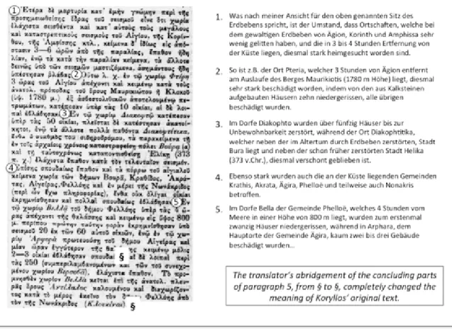
As it can be clearly seen in Figure 10, part (b) was loosely translated from Greek into German, and the translator heavily cut the pristine report by Koryllos. The long paragraph at the beginning of part (b) is written in a really convoluted language and cryptic manner,
as it is an attempt by Koryllos to distinguish effects to settlements close to the coast from those caused to places located two to six hours inland, to support Forster’s theory and interpretation of the earthquake focus. This elaborate section probably challenged the translator, who decided to solve the problem with sharp and random abridgments of the original text, and especially of paragraph (5) in Figure 10.
Galanopoulos did not take into account the Greek version by Koryllos, and this is confirmed by the fact that he did not reference at all the newspaper Ephimeris, where the report was published, among the items he considered for the 1889 earthquake. Besides, when discussing the abridged German version of the report by Koryllos, Galanopoulos never cited him by name, perhaps attributing his report to Philippson (1889b).
In conclusion, the observations on all the places at which damage was assessed by Galanopoulos, and those who trusted his interpretation based upon Koryllos via the German version in Philippson (1889b) only, were considered unreliable, and discarded. The testimony of Koryllos as an eyewitness is here constrained to the first lines of his report (see above, point a), in which he described the effects at Patras. Such a restoration of the original value of the report by Koryllos is further supported by the fact that the enlarged set of contemporary newspapers do not supply any records about damaging effects at Pteri, Vela, Diakopto, but also at Aigio, Krathis, Akrata, Klimenti, Matzani, Kalavryta, Arphara. These are the ten settlements in Achaea forming one of the two “core pleistoseismic areas of degree 7-8 [… the one] leading up from the Gulf of Corinth to the northern Peloponnese mountains” according to Galanopoulos (1953,10.4, p.227, see Figure 9). The enlarged set of newspapers provided records on 24 places not mentioned by any other contemporary source (see Table S7 in the electronic supplement to this article for detail), and all confirm
the re-interpretation of the report by Koryllos here proposed, together with the new distribution of effects.
The severest effects of the Sunday 25 August 1889, 21:13 (Athens time) earthquake are reported at some settlements of Aetolia-Acarnania (Figure 11). According to official reports, as summarized in the press (Ephimeris, 1889g), at Aitoliko i) 36 houses broke down seriously; ii) 50 were in danger of collapsing; iii) 18 houses collapsed partly and were left completely unfit for habitation; iv) 37 collapsed and were no more inhabitable, and v) 9 buildings were fissured and in danger of becoming uninhabitable.
There is no public utility edifice missing from the engineer’s survey of damaged buildings at Agrinio: the local branch of the National Bank, the police station, the army hospital, the garrison headquarters, the gymnasium, the boarding school, the public accounts offices, the courthouse, the telegraphic and municipal offices (Ephimeris, 1889g). The 81 buildings made “uninhabitable” by the earthquake are listed according to the owners’ names in an appeal to the Prime Minister; all the others are said to have suffered relevant damage, except for 20 units which were either insignificantly or not damaged (Akropolis, 1889e).
Although the figures of damaged buildings in Aitoliko and Agrinio slightly oscillate in the newspapers, higher in Akropolis (1889h) than in the same day issue of Nea
Ephimeris (1889g), a clear assessment of the grade of damage in EMS98 was prevented by
the persistent use of the wording “unfit for habitation”, focusing on the consequence rather than on the type of damage suffered.
Although details are scarce, damage was extensive also in Astakos, and in Patras. The outstanding testimony about Patras is Koryllos (Ephimeris, 1889m). Besides being an
eyewitness, he described the characteristics of the pendulum he had installed in his laboratory, together with his readings of the recordings. Coherently with items in the press, he wrote that “almost all the houses here [Patras] and many in the countryside and the neighboring villages were damaged in a more or less evident way, some were so affected to the point of being uninhabitable, one completely collapsed, with the fall of its southern and northern walls.” His education and professional skills as a medical doctor reveal in the detailed descriptions of the injuries suffered by “two women and one old man”.
Intensity values in EMS98 were assigned at 41 different places (Figure 11, and Table S7 in the electronic supplement to this article), with the highest located in Aetolia-Acarnania, that is 8-9 at Aitoliko, and 8 at Agrinio. In 28 places intensity did not exceed degree 4 EMS98.
This earthquake was widely felt in Greece, in an area stretching from Athens in the east to Volos in the north, and south at Kalamata (Messenia) in southwestern Peloponnese. It was also felt outside Greece, at some places on the coast of Apulia (Italy) to the west of the most damaged region (Bollettino, 1889) (Figure 11).
Forster (1890) reported that both telegraphic cables in the Gulf of Corinth ruptured, the one laid in 1884 completely fractured off Xylocastro, and the one laid in May 1889 off Nafpaktos, respectively. While some modern studies (e.g. Galanopoulos, 1953; Ambraseys, 2009) strictly linked both cable ruptures to the extension of the damaging area, according to Forster himself only the rupture off Nafpaktos should be related to the August 1889 earthquake.
Liquefaction phenomena close to Aitoliko are similarly described in seven newspapers: “Outside the town in the western part, at a distance of about forty meters from
the sea, the ground fissured, holes were formed in a line starting to the right of the road Aitoliko-Neochorios, crossing it, and ending to the left, of a length of 150 meters. The holes, from which spurt out water and sand, have the shape of a funnel, and their surface shows that water and sand were rotating while gushing out” (e.g. Palingenesia, 1889b).
Results and discussion
Macroseismic intensity data
In all, the observations of macroseismic effects retrieved amount to 543, supplied by 116 contemporary, independent sources of information, made of 90 press issues for 1861, 1888 and 1889 earthquakes, and 26 other types of sources. Figure 12 illustrates the relative contribution of records derived from press items, altogether 426 relative to the 1861, 1888 and 1889 earthquakes, versus 117 records from other types of sources.
These 543 records allowed us to assign 143 intensity values in EMS98, concerning 108 different localities, out of which only the 49 with ≥3 records are shown in Figure 12. Although four localities are in Apulia (Italy), and the remaining are mostly concentrated in Central Greece and northern Peloponnese, the geographic coverage of the 143 IDPs is much improved with respect to that of previously published studies, and in particular when considering the spatial distribution of the earthquake effects on the occasion of each earthquake (Figures 4, 6, 8, 11). The number of IDPs for each earthquake ranges from 3 for the 1748 earthquake to 72 for the 1861, with values from 9 to 2 EMS98. A total of 53 intensities are in the classes from 9 to 8 (including 8-9), while 90 are encompassed in all classes between 7-8 and 2.