See discussions, stats, and author profiles for this publication at: https://www.researchgate.net/publication/224969485
Improved positioning using GSM and GNSS tight hybridization
Conference Paper · March 2008CITATIONS 5
READS 68
5 authors, including:
Some of the authors of this publication are also working on these related projects:
Wher65View project
Low cost CPV in MoroccoView project Philippe Paimblanc
Telecommunications for Space and Aeronautics 12 PUBLICATIONS 30 CITATIONS
SEE PROFILE
Sadiki Tayeb
Université Internationale de Rabat 43 PUBLICATIONS 69 CITATIONS
SEE PROFILE
Francis Castanie
Ecole Nationale Supérieure d’Electrotechnique, d’Electronique, d’Informatique, d… 164 PUBLICATIONS 905 CITATIONS
SEE PROFILE
All content following this page was uploaded by Francis Castanie on 20 December 2013. The user has requested enhancement of the downloaded file.
Improved Positioning using GSM and GNSS Tight
Hybridization
P. Paimblanc, Navigation Systems, TESA Laboratory, W. Chauvet, Telecommunication Systems, TESA Laboratory,
D. Bonacci, Signal Processing, TESA Laboratory,
T. Sadiki, Telecommunication and Signal Processing, TESA Laboratory F. Castanié, Director, TESA Laboratory.
BIOGRAPHY
Philippe Paimblanc graduated as electronics engineer from the ENAC (Ecole Nationale de l’Aviation Civile) in 2002 and received the same year his Master research degree in signal processing. He performed a PhD at the satellite navigation lab of the ENAC. He is now a research engineer at TéSA laboratory, in Toulouse, France.
Wilfried Chauvet was born in 1976 in France. He got his Engineer degree from INT (National Institute of Telecommunications), his PhD from National Polytechnics Institute of Toulouse in 2004. He is now Research Engineer at the TESA Laboratory. His research field is Signal Processing in Telecommunications. David Bonacci was born in 1974. He got his Engineer degree from ENSEEIHT in 1999, his Ph.D. from National Polytechnics Institute of Toulouse in 2003. He is now a Research Engineer at the TESA Laboratory since 2005. He teaches essentially adaptive and classical Signal Processing at the undergraduate and graduate level. His research activity is centred around radar, parametric modelings, subband decomposition, positioning and particle filtering.
Tayeb Sadiki received his Telecommunications
Engineering degree from Université Polytechnique de Nice Sophia-Antipolis, in 2003. He received his PhD degree from Eurecom, Sophia-Antipolis in Bayesian Adaptive Filtering in March 2007. He was student paper finalist at ASILOMAR, California 2006. From March 2007 to March 2008 he was a systems engineer at France Télécom Orange, working on design of service-providing systems for telecommunication networks. In March 2008, he joined the Telecommunications for Space and Aeronautics (TeSA) Lab as R&D engineer, working on mobile location. His current research interests are scheduling for multi-user MIMO systems, Mobile location, GNSS, Hybridization, Adaptive Filtering, precoder design in MIMO systems based on partial channel state information, transceiver design in wireless MIMO-OFDM and adaptive receivers for WCDMA systems.
Prof. Francis Castanié has got his PhD and his Doctorate of Sciences degree from National Polytechnics Institute of Toulouse (INPT) respectively in 1971 and 1977. He teaches essentially Signal Processing at the undergraduate and graduate level. He gives several doctoral courses in the following topics: Time-Frequency and Wavelet Analysis, Parametric Signal and Time Series Modeling, Digital Signal Processing. Prof. Castanié is the Director of the Research Laboratory Telecommunications for Space and Aeronautics (TeSA). Together with this activity in TeSA, he joined the CNRS Institut de Recherche en Informatique de Toulouse (IRIT) in 2002, where he is heading the Signal and Communication Group. He has several responsibilities in research societies at the national level (SEE) and at the international level: he had been Chairman of the French Chapter of Signal Processing of the IEEE, from 1992 to 2002. He authored or co-authored more than 52 papers (among which an International First Prize and a Best Paper Award), and more than 240 communications in international conferences. He has 7 international patents, and has co-authored around 99 industrial contracts reports. During his 30 years of career, he has been the advisor of more than 60 Ph. D. students.
INTRODUCTION
As Global Navigation Satellite Systems (GNSS) receivers become widespread, more service providers rely on the knowledge of the user’s position in order to perform various applications: fleet tracking, emergency calls regulations (E911 in the US and E112 in Europe), mountain and seaborne rescue or positioning of dependent persons (children, ageing people) and animals. However, the performances of GNSS-based positioning systems can be seriously affected in environments where the demand for accuracy is highest (urban and indoor environments), due to masking of satellites by buildings and multipath effects.
The four criteria commonly used to quantify or qualify these performances are: accuracy, availability, continuity and integrity. Thus, this paper focuses on the possibility of improving system performances in terms of accuracy
and availability, by hybridizing GNSS signals with wireless telecommunication systems (such as GSM, Wifi, UWB and DVB television signals) that are often widely deployed in urban and indoor environments. Within this GNSS/telecommunications hybridization framework, TESA laboratory works simultaneously on three projects: FIL (Information Fusion for Localization), TRANSCONTROL (control and follow-up of dangerous goods transportation) and SINAFE (innovative positioning systems for river traffic). The present paper is based on previously published work [10], the main updates being the use of a more realistic GNSS measurement model (including multipath and residual troposphere error) and a new telecommunications channel. Here, a multipath model is considered instead of a direct path model with shadowing.
The purpose of this study is to use information provided by systems which are widely deployed but not dedicated to positioning such as GSM and Wifi beacon frames (which can provide timestamps, emitted and received power values), as opposed to, for instance, Assisted GPS (A-GPS) which uses telecommunication channels to provide the receiver with information easing satellite signals acquisition.
The data thus collected can then be used to compute the user’s position, using one the three main classes of methods present in the literature:
• AOA (Angle Of Arrival). This method lacks the accuracy needed to be actually helpful, as compared to the two following kinds of methods.
• DTOA (Difference Time Of Arrival). This method consists in measuring the duration of the path of the electromagnetic wave (moving at light speed) between the emitting antenna and the receiver and to apply then triangulation techniques.
• Methods based on received electromagnetic signals powers: they can be split in 2 subfamilies: methods based on a database containing a power profile (only applicable indoors in an immobile environment) and methods based on the use of a propagation model and triangulation. This last sub-family of methods is more complex and costs more computational time but is much more adaptive regarding environmental changes.
The main scientific issues met in such a study are the following:
• Synchronization problems when using the DTOA method (the accuracy of the synchronisation must be consistent with the measured values, which are of the order of the nanosecond).
• Multipath effects and possible difficulties in identifying the direct path.
• Hybridization brings a complex theoretical problem: find a way to best mix several kinds of measurements (such as GNSS pseudoranges, received powers or times of arrival) by
automatically assigning a reliability index to these measurements.
PROBLEM FORMULATION GNSS Measurement Model
GNSS positioning is based on triangulation (or circular positioning): the distances between user and satellites are obtained by multiplying travel time by the speed of light and expressed as functions of the satellites’ and user’s coordinates. Travel time is measured by comparing the time of emission (provided by the satellite) and the time of reception (measured by the user). Satellite clocks can be synchronized with a global GNSS time using information contained in the navigation message broadcast by the satellites themselves. However, the offset between the user’s clock and GNSS time cannot be predicted and needs to be estimated at the same time as his position. Thus, the GNSS measurements that are actually processed by the positioning algorithm are not ranges but rather pseudoranges, which have the following structure [1]: i u i i
t
c
r
y
=
+
∆
+
ε
(1) Where:• ri is the true geometrical distance between the
satellite antenna and the user receiver antenna,
•
∆
t
u is the user receiver clock offset with regard to GNSS time,•
ε
iis the sum of the measurement errors due to multipath, background interference, noise, ionospheric and atmospheric propagation delay residuals, satellite clock residuals.
For the present article, the pseudorange measurements were generated. Realistic satellite trajectories were simulated through the use of YUMA ephemeris data and used to compute pseudoranges based on the theoretical user position and clock bias. The simplified noise model which was used here consisted in considering
ε
i to be composed of multipath, residual tropospheric error (resulting from non-perfect tropospheric delay models) and Gaussian noise. Multipath was generated assuming that, for each epoch, two reflecting objects were present in the vicinity of the receiver’s antenna. The residual tropospheric error was generated using a model depending on the satellite’s elevation [2]:i tropo
a
α
τ
2sin
+
where
α
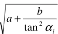
i is the elevation of satellite i.The remaining Gaussian noise is assumed to be centred, with a standard deviation function based on the satellite’s elevation from the user’s point of view [2]:
.
tan
2 ib
a
α
+
This model is illustrated in figure 1. In the following simulations, the same standard deviation model has been used to generate the measurement noise covariance matrix.
Fig. 1. Evolution of standard deviation with regards to satellite elevation
Since there are four unknowns (the user’s coordinates plus his clock bias), there must be at least 4 available satellites for a navigation solution to be computed. Although this number is guaranteed to be reached in open space, it is often not met in more restricted environments such as urban areas. Thus, GNSS measurements are to be complemented with power measurements performed on GSM signals.
GSM Channel Model
In a GSM network, BTS (Base Transceiver Station) continuously transmit a beacon signal. The power of this signal is received by the mobile and allows the mobile to choose the BTS with the most powerful signal in order to get a communication. We propose to use the power of this continuous signal for positioning purpose. When propagating in a free space, RF signal is subject to an attenuation given by the Friis Formula [3]:
r e e r G d G P P = 2 4π λ (2) Where:
•
P
r received power at user antenna (W)•
G
e linear gain of the emitter antenna•
λ
wavelength (m)•
d
distance between emitter and receiver (m)•
G
r linear gain of the adapted receiver
In the following, we will assume that the propagation channel consists of several paths. Hence, received signal s(t) is a linear combination of L attenuated delayed versions of the emitted signal e(t) according to the following relation :
∑
− = − − = 1 0 ) ( ) , , , ( L k k k c d t e a t x y x s τIn this relation, d is distance between the emitter and the mobile and c is the light celerity. Hence, there is a direct path if there is a zero delay τk =0. In the following, we make the assumption that the channel only depends on the space position of the mobile and that a perfect channel estimation is processed at the receiver side relying on state channel pilot symbols. The received power at a location (x,y,z) is therefore given by :
) ) ( ) ( ( ) ) , , , ( ( ) .. , / , , ( 1 0 1 0 2 1 1 0
∑∑
− = − = − − − − − = = L k L j j k j k L r c d t e c d t e E a a z y x t s E a a a z y x P τ τIn this expression, attenuation coefficients and values of delays are of course dependent of the location (x,y,z). Here we make the additional assumption that
C j k−τ >>T
τ for 0≤k,j≤L−1 where TC is the
correlation time of the emitted signal. Actually, this assumption means that multipaths are due to reflexions far from the mobile and not in the vicinity of the mobile. This assumption leads to:
x j k j k P c d t x c d t x E( ( −τ − ) ( −τ − )=δ( − )
.So, assuming
1 = x P, we get:
∑
− = − = 1 0 2 1 1 0, .. ) / , , ( L k k L r x y z a a a a PAttenuation of multipaths are due to two phenomena: the free space loss and absorption. The first component is given by the Friis relation (2) and only depends on the distance travelled by the wave. The absorption is caused by the reflexions and propagation of the microwave through obstacles. This phenomena leads to the product of independent attenuations and can be modeled by a lognormal distribution for each path. Namely, X is distributed according to a lognormal distribution if 10log(X) is Gaussian. As a consequence, we have the following expression for ak2:
free k k k L a2 =α2ρ2 Where : r k e e free k G c d G P L + = 2 ) ( 4π τ λ ) , ( : ) log(
10 ρk2 normaldistributionN mmulti σmulti2 ) , ( : ) log( 10
α
2 normaldistributionN mσ
2 In this expression of a , k2 2α stands for the global attenuation that is the same for all paths. This attenuation characterizes the global environment (high density of building, low density of building…). In addition, a specific attenuation for each path is given by ρk2.
Delays are distributed according to an uniform distribution between 0 and τmax. The following figure illustrates the multipath channel.
BTS 1 BTS i Mobile BUILDING Tree Path 1 from BTS1 Path 2 from BTS1
One Path from BTSi
Fig. 2. Illustration of the multipath channel
In addition, the channel is described by a spatial correlation Lc. This coherence value is a statistical value that gives an indication on how far the mobile has to move to get a new realization of the channel process (attenuations of multipaths and delays of multipaths). Another parameter is the sampling period Te for the power measurement. Simulator of the attenuation ρk for a mobile moving with a speed vmobile is given by the following figure. Independant samples generated according to ( , 2 ) multi multi m σ Ν
Normalised Low Pass filter with normalized cutoff
frequency : e C mobile norm T L v B = 100.1.( ) Attenuation sample
Fig. 3. Filtering process for spatial correlation
Attenuations α2
and
delays are also obtained with such a low pass filter to get the spatial continuity. Finally, the total received power in dBm (from a BTS at a distance d of the mobile) is given by :) log( 10 ) ) ( log( 10 2 1 0 2 2 α τ ρ + + + =
∑
− = L k k k dBm measured c d K PThe constant K is given by:
) 4 log( 10 PeGe Gr K = λπ
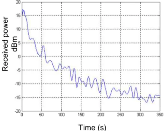
As an illustration, we plot the received power of a mobile going away from a BTS with a speed vmobile = 20 km/h
(Lc=50m,
m
= 1, σ2=
0 dB, mmulti = 1,2
multi
σ = -20 dB, L=3, τmax=100/c ) on figure 4. Received power is given in dBm (logarithmic relative power for a reference power of 1 mW). Time (s) R e c e iv e d p o w e r d B m
Fig 4. One realisation of the power profile
The numerical values for simulations in the next part are:
• Parameters for BTS:
– Pe = 45,5 dBm (35W). This value of emitted power is value of BTS of power Class 4 [5]. – Ge = 17 dBi (value for a trisectorized antenna) –
λ
= 33 cm (value for a GSM frequency of 900MHz)• Parameters for channel : –
L
= 3, Lc = 50 m –m
= 1, σ2 =-10 dB – mmulti = 1, 2 multi σ = -20 dB• Parameters for mobile: – Gr = 0 dBi
– vmobile = 40 km/h
– Te = 1 s
Performance Criteria
The addition of GSM power measurements to the positioning algorithm is expected to increase performance levels on two aspects: accuracy and availability. Their practical definition will be derived from the formulations used in civil aviation:
• Accuracy: it is the degree of conformance between the estimated or measured position and/or velocity of a platform at a given time and its true position and/or velocity.
• Availability: it is the ability of the navigation system to provide the required function and performance at the initiation of the intended operation. It is expressed as a percentage of time.
GNSS-GSM Particle Filter Fusion Algorithm
Realtime estimation and fusion has been widely implemented using the Kalman Filter [6] (or one of its numerous variants) for several decades because of the low computational power consumption of this algorithm and because of its robustness. New calculators provide much more computational power so that one can now benefit from non-linear filtering techniques (see [7] for a presentation). In addition to optimal nonlinear modeling, they allow to treat optimally the presence of non gaussian noise on observations or state transition equations. This is
usually particularly convenient for state transition noise because some a priori information on the pdf (probability density function) can be included by this way (observation noise can often be considered as gaussian, due to the Central Limit Theorem). Moreover, these non linear filtering techniques are suited directly to a large variety of physical equations (often non linear) whereas Kalman filter requires linearizations that can be inaccurate in some situations. Positioning algorithms are a perfect example where particle filtering is very useful because the system experiences abrupt changes (the number of satellites and BTS in sight can vary over time) and because of the non linearity of equation (1).
Under Markov assumptions, the joint probability distribution between states and observations depends only on the state transition probabilities and observation probabilities. As a consequence, evolution and observation models have to be determined. We have considered here an identity evolution model perturbed by white gaussian noise and a non-linear observation model given by the concatenation of equations (1), (2) and (3) below: 2 2 2
)
(
)
(
)
(
t ti t ti t ti iz
z
y
y
x
x
r
=
−
+
−
+
−
(3)Where
x
ti,
y
ti,
z
ti are the satellite i ECEF coordinates. This problem involves the estimation of hidden variables (target position coordinates) thanks to observations. More precisely, 4 variables have to be estimated and compose the particle filter state vector:• xt, yt and zt: the target coordinates in ECEF
(Earth-Centered, Earth-Fixed) Cartesian coordinate system.
•
∆
t
u, the user receiver clock offset with regardto GNSS time (depends only on the user’s receiver).
The state vector can be decomposed into 2 blocks of variables: the first one is composed of the user’s coordinates xt, yt and zt and the second one is the user
receiver clock offset
∆
t
u. For given values of xt, yt and zt,the value of ri is fixed because of equation (3). A linearly evolving clock offset
∆
t
u versus time is considered.Thus, conditionally to the first block of state variables, the second one appears as a linear Gaussian structure. In these conditions, it is possible to implement an efficient particle filtering strategy called “Rao-Blackwellisation” for which the linear part of the model is resolved analytically by Kalman filtering. The Rao-Blackwellised particle filtering has been presented independently in [8] and [9]. It allows reducing significantly the variance of the estimates in the case of such models (conditionally linear gaussian) by reducing the dimension of the vector estimated by particle filtering.
SIMULATIONS
Framework of the Simulations
Simulations are leaded to show the improvement brought by hybridization of extra data (here GSM powers) with the GNSS pseudoranges using a Particle Filter data fusion algorithm.
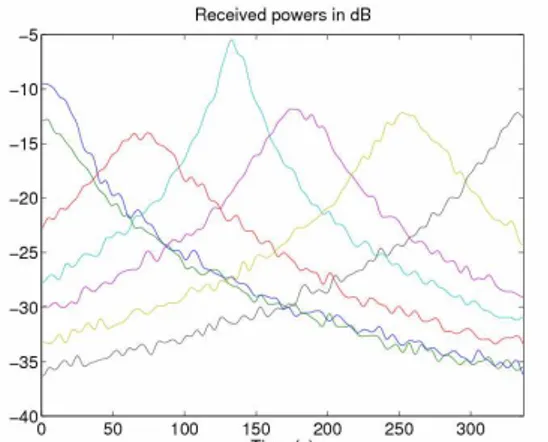
The following scenario is considered: A vehicle is moving straight on a road in Toulouse from point A to point B. 7 BTS are supposed to be in sight, placed along the road as shown in figure 5 and their exact position is supposed to be known. The distance between point A and point B is 3742 m and the vehicle, starting from point A, gets point B in 377 seconds (its speed is constant and around 40 km/h).
Fig. 5. Simulation scenarios
We propose to investigate a positioning solution based on GNSS pseudoranges and GSM Received Power. This method does not require extra equipment since it only relies on the received power of the GSM mobile. Hence, we make the assumption that the vehicle is able to measure separately the received power of signals emitted by several BTS of the GSM network. Two different scenarios are considered. The first one points out the improvement in terms of accuracy when additional GSM received powers are provided. The second one aims at showing how the use of additional GSM measurements impacts the levels of availability of the global system. Scenario 1: 4 GNSS satellites are in sight. 7 BTS are also in sight. For such a scenario, each of the GNSS satellites provides a pseudorange. This number of satellites would be sufficient to get a position of the vehicle. But we propose a hybridization of the GNSS pseudoranges with the GSM powers. We propose to use a particular filter as a hybridization algorithm. Observation equation of the particle filter will integrate the models for GNSS pseudoranges and free space loss for GSM powers (cf equations (1) and (2)). Simulations are performed in order to compare positioning accuracy with and without the use of the GSM powers.
Fig. 6. Received GSM powers from the 7 BTS versus time
Scenario 2: At the beginning of the trajectory, 4 GNSS satellites are in sight and 7 BTS are also in sight as in the first scenario. Between t = 51 s and t = 106 s, the road passes through large building after the “pont neuf” and it is supposed that no GNSS pseudorange measurement is available. The determination of the position of the receiver is then not possible using only GNSS system. However, positioning through GSM powers remains possible through the Particle Filter Fusion Algorithm as in the first scenario. Simulations are performed in order to show how the level of availability can be increased thanks to the GSM powers.
Simulation Results
With respect to scenario 1, simulations have shown that the use of GSM powers in addition to GNSS pseudoranges can improve positioning results in terms of accuracy as shown in figures 7 and 8 where are depicted the estimation error given by the norm of the vector formed by the difference between the true simulated position and the estimated one.
The second scenario aims to show the improvement brought by the GNSS and GSM measurement fusion in terms of availability. Between t = 51 s and t = 106 s, the GNSS positioning system is not available and is replaced by the position derived from GSM power measurements. It can be noted that, even if the error is far larger, a position estimate is still available (see figure 9).
Fig. 7. Positioning error vs time for scenario 1 without GSM powers
Fig. 8. Positioning error vs time for scenario 1 with 7 BTS in sight
Fig. 9. Positioning error vs time for scenario 2 with 7 GSM BTS in sight and 0 satellite available between t=51 and t=106 s CONCLUSION
In this paper, a way of improving the positioning performance of the GNSS system through hybridization with distances derived from GSM power measurements was proposed. The GNSS/GSM Fusion algorithm was an APF (Auxiliary Particle Filter) algorithm with UKF (Unscented Kalman Filter) proposal and Rao-Blackwellisation allowing tight hybridization of GPS and GSM measurements. Scenario 1 and 2 showed an improvement in terms of accuracy and availability thanks to the use of GSM received powers in addition to GPS pseudoranges in a realistic scenario.
Several perspectives can be given: First, the automatic estimation of hyperparameters: PF algorithms can be used to perform joint estimation of some global parameters (as for instance observation and evolution noises variances). This would give the fusion algorithm a better adaptability to local situations. Finally, the use of “multiple models” formulation can be envisaged: ability of PF algorithms to select automatically the most adapted model among a bank of available evolution and observation models. This would allow the algorithm to deal better with multipath effects.
ACKNOWLEDGEMENTS
The authors are indebted to the ANR (French National Agency for Research), the DGE (Direction Générale des Entreprises), the Midi-Pyrénées region and the ‘Grand-Toulouse’ administrative districts community for their financial support through the FIL and TRANSCONTROL programs.
REFERENCES
[1] B.W. Parkinson, J.J. Spilker Jr., P. Axelrad, and P. Enge, Global Positioning System: Theory and Applications Volume I, American Institute of Aeronautics & Astronautics, June 1996.
[2] P. Paimblanc, C. Macabiau, B. Lobert, M. Van Den Bossche, and S. Lannelongue, “Implementation of robust algorithms in the Galileo integrity monitoring concept,” in Proceedings of the ION GNSS 18th International
Meeting. Institute Of Navigation, September 2005. [3] Simon S. Saunders, Antennas and propagation for
wireless communication systems, Wiley, 1999.
[4] M. Patzold, U. Killat, F. Laue, and Y.Li, “On the statistical properties of deterministic simulation models for mobile fading channels,” IEEE Trans on Vehicular
Technology, vol. 47, no. 1, 1998.
[5] Technical Specification Group GSM/EDGE, 3GPP
TS 45.005 V7.12.0 Radio Access Network, Radio transmission and reception, 3rd Generation, Partnership Project, November 2007.
[6] R. Kalman, “A new approach to linear filtering and prediction problems,” Trans. ASME, pp. 35–45, 1960. [7] A. Doucet, N. de Freitas, and N. Gordon, Sequential
Monte Carlo Methods in Practice, Springer, New York, 2001.
[8] R. Chen and S.J. Liu, “Mixture kalman filters,”
Journal of the Royal Statistical Society, vol. 62, no. 3, pp. 493–508, 2000.
[9] A. Doucet and C. Andrieu, “Particle filtering for partially observed gaussian state space models,” Journal
of the Royal Statistical Society, vol. 64, no. 4, pp. 827– 836, 2002.
[10] D. Bonacci , W. Chauvet, P. Paimblanc, F. Castanié, “Improving vehicles positioning using wireless telecommunication media and GNSS hybridization”, WIT 2008: 5th International Workshop on Intelligent Transportation March 18th -19th, 2008.
View publication stats View publication stats