TOPO-EUROPE: Coupled Deep
Earth – Surface Processes in Europe
S . A . P . L . C L O E T I N G H* a n d P . A . Z I E G L E R* * *
Department of Tectonics, Faculty of Earth and Life Sciences, VU University Amsterdam, The Netherlands. E-mail: [email protected];
**
Geological-Paleontological Institute, University of Basel, Switzerland. E-mail: [email protected]
TOPO-EUROPE is a multidisciplinary international research program that addresses the interaction of processes inherent to the deep Earth (lithosphere, mantle) with surface processes (erosion, climate, sea level), which together shaped the topo-graphy of Europe. The objective of the TOPO-EUROPE project is to assess neo-tectonic deformation rates and to quantify related geo-risks, such as earthquakes, flooding, landslides, rock falls and volcanism. Research, incorporating iterative data interactive modelling, focuses on the lithosphere memory and neotectonics, with special attention on the thermo-mechanical structure of the lithosphere, mechanisms controlling large-scale plate boundary and intraplate deformations, anomalous subsidence and uplift, and links with surface processes and topography evolution. The TOPO-EUROPE natural laboratories, in which these processes are analysed, cover a wide range of geodynamic settings. These include the post-collisional Alpine/Carpathian/Pannonian-Basin system, the very active Aegean-Anatolian and Apennines-Tyrrhenian orogens and back-arc basins, the Caucasus-Levant area in the Arabia-Europe collision zone, the Iberian Peninsula caught up between Alpine orogens, the meta-stable West and Central European Platform, the stable East-European Platform and the seismically active and elevated Scandinavian con-tinental margin. The TOPO-EUROPE project is a component of the International Lithosphere Program and was initiated with the support of Academia Europaea. A European Science Foundation EUROCORES project provides funding for part of the TOPO-EUROPE research. Other parts of TOPO-EUROPE require support by participating organizations.
Rationale for TOPO-EUROPE
Continental topography is at the interface of deep Earth, surface and atmospheric processes. Topography influences society, not only as a result of slow landscape
changes but also in terms of how it impacts on geohazards and the environment. When sea-, lake- or ground-water levels rise, or land subsides, the risk of flooding increases, directly affecting the sustainability of local ecosystems and human habitats. On the other hand, declining water levels and uplifting land may lead to higher risk of erosion and desertification. In the recent past, catastrophic landslides and rock falls in Europe have caused heavy damage and numerous fatalities. Rapid population growth in river basins, coastal lowlands and mountainous regions and global warming, associated with increasingly frequent exceptional weather events, are likely to exacerbate the risk of flooding and devastating rock failures. Along active deformation zones, earthquakes and volcanic eruptions cause short-term and localized topography changes. These changes may present additional hazards, but at the same time permit us to quantify stress and strain accumulations that are of prime importance for seismic and volcanic hazard assessment. Although natural processes as well as human activities cause geohazards and environmental changes, the relative contribution of these two components is still poorly understood. That topography influences climate has been known since the beginning of civilization, but it is only recently that we have been able to model its effects in regions where good (paleo-) topographic and climatologic data are available.
The present state and behaviour of the Shallow Earth System is a consequence of processes operating on a wide range of time scales. These include the long-term effects of tectonic uplift, subsidence and the development of river systems, residual effects of the ice ages on crustal movement, natural climate and environ-mental changes over the last millennia and up to the present, and the powerful anthropogenic impacts of the last century. If we are to understand the present state of the Earth System, to predict its future and to engineer our use of it, this spectrum of processes, operating concurrently but on different time scales, needs to be better understood. The challenge to Geosciences is to describe the state of the system, to monitor its changes, to forecast its evolution and, in collaboration with others, to evaluate modes of its sustainable use by human society.
Topography and natural hazards
To gain a better understanding of the interrelation between topography, geohazards and the environment, the temporal evolution of topography needs to be assessed, not only during the recent past but also during the last 10 or so million years. There are, however, some fundamental problems inherent in paleo-topography analysis. Apart from dealing with topography that no longer exists, its dimensions and the timing of events and the underlying dynamic processes that controlled its develop-ment, as well as its life cycle, pose major challenges. These cannot be solved by a single sub-discipline but require support by other disciplines. The geographic scope of the TOPO-EUROPE programme demands co-operation on a European
scale to avoid a fragmented approach. Mountain ranges (increasing surface topography) and adjacent sedimentary basins (decreasing surface topography) record signals and proxies that tell the story of the topographic life cycle. In this, the sediment source-to-sink relationship (Figure 1) is of key importance. However, signals and proxies are still poorly understood and we have only just started to decipher the few we are aware of. A major challenge is to extract all available information contained in the system and to interpret it in terms of processes. Innovative analytical techniques, improvement of methodologies, back-to-back with innovative data interactive backward and forward modelling, are required to resolve these problems.
The main challenge in topography-related geological hazard research is to create and verify physical models of hazardous Earth systems that integrate all relevant data, describe hazards as a function of time, and understand them as resulting from the evolution of a non-linear system under which processes acting on various temporal and spatial scales can become catastrophic. In this context, it must be understood that topography plays a prominent role as it results from the interaction of shallow and deep Earth processes, and as such permits – in combination with other parameters – to assess the state of stress and its change through time.
There are obvious relations between geological hazards and topography. Topography is a major factor controlling slope instabilities, which can lead to the development of landslides, both on- and offshore. Uplift of, for example, Fenno-scandia and the Romanian Carpathians area has caused increased landslide and rock-fall hazards. The second important parameter for catastrophic earth move-ments is the internal friction of soil, which in turn depends largely on hydrological conditions and the intensity of precipitation. Regional climate changes associated Figure 1. Schematic source-to-sink systematics and coupled orogen-basin evolution in the aftermath of continental collision in the Romanian Carpathians
with the decay of permafrost and/or increasing precipitation tend to cause increased slope instability and corresponding landslide and rock-fall activity.
Earthquakes result from brittle deformation of the crust and mantle and occur in various parts of Europe (Figure 2).
Although areas with a high frequency of large magnitude earthquakes are mostly bound to the Alpine–Mediterranean system of orogens, certain parts of the European intraplate domain are also characterized by elevated seismic activity. In areas such as the Rhine Graben, the concentration of population centres and high-value infrastructure can turn moderate hazards into large risks. The currently used ‘third generation’ hazard assessment method can be coined ‘seismotectonic probabilism’. This method largely relies on historical and paleo-seismological earthquake records, and results in maps giving an annual exceedence probability of a certain damage parameter. The challenge to Solid-Earth science researchers lays in developing fourth-generation hazard assessment methods, relying much more Figure 2. Areas of Western and Central Europe, which are exposed to increased geohazards owing to ongoing vertical crustal movements, demon-strating the societal relevance of neotectonics (after Ref. 24)
on a physical understanding of processes leading to earthquakes and on assessment of the actual state of stress on faults. The state of stress is strongly influenced by surface topography, but also by the topography of lithospheric boundaries (Moho, lithosphere-asthenosphere boundary) (see Figures 3–5). Highly sophisticated models for time-dependent hazard assessment that link several processes, such as mantle dynamics, structure and rheology of the crust and mantle (Figures 6–9), change in topography, mass re-distribution by erosion and sedimentation, and post-seismic relaxation can be established today. Verification of these models requires data on recent deformation (both from GPS and geological reconstruction for the Holocene/ Pleistocene) and tectonic stress (e.g. through the World Stress Map project). This can yield substantial new insights into the stress and strain evolution of key seismogenic areas of Europe. This type of modelling may develop into a particularly viable approach for constraining extreme events with high societal impact.
Intraplate seismicity (Figure 10) is still poorly understood and tends to follow episodic intermittency patterns rather than quasi-periodic earthquake activity more characteristic for plate boundaries. TOPO-EUROPE will establish a data-base that allows for a systematic combination of lithospheric data (e.g. geometry of boundaries, temperature, stress, structure) and recent movements, including topography changes over an area that covers all levels of seismicity, such as highly active plate boundary domains, moderate intraplate activity, and seismic quiescence.
10W 0E 10E 20E 30E 40E 40N 50N 60N
Figure 3. Seismicity map of Europe, reflecting pattern of ongoing crustal deformation. Red dots: earthquake epicentres according to NEIC data centre. Circles with plus symbols: areas of Neogene uplift. Circles with minus symbols: areas of Neogene subsidence. Background elevation image derived from the ETOPO2 data set
Europe is exposed to recurrent flooding events that pose major hazards to population and industrial agglomerations. The damaging potential of floods is intrinsically linked to even minor topographic changes that control the depth of inundation. For TOPO-EUROPE it is a challenging task to combine regional cli-mate predictions with changes in sea and river level, and subsidence and uplift data on Holocene topography development to quantify Europe’s future flood hazards.
The main risk-generating factor for human society is the increased exposure and vulnerability of its assets (buildings, infrastructure, and social systems). Figure 4. Thickness of the European lithosphere as determined by (a) seismic tomography; (b) surface wave tomography; (c) geothermics; (d) magnetotel-lurics (after Ref. 25)
During the past 150 years, anthropogenic modifications of the planetary envir-onment have, however, also caused changes in the hazard potential. For instance, extraction of large amounts of ground water beneath and near cities modifies surface elevations and thus their inundation potential during floods. At the same time, this impacts on the stability of the subsurface with consequences for ground motions during future earthquakes, the associated liquefaction potential, and landslide hazard. Again, TOPO-EUROPE opens avenues to systematically address these issues on a European scale.
The TOPO-EUROPE network
The TOPO-EUROPE network, which aims at tackling the challenges of con-tinental topography research, was officially launched during a symposium held in October 2005 under the auspices of Academia Europea in the premises of the
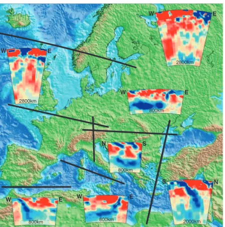
E W E W W E N S E W S N 2800km 2000km 800km 800km 800km 800km 2800km
Figure 5. Tomographic cross-sections through key parts of the European continent (after Ref. 26). Red and blue colours indicate respectively hot and cold domains in the upper mantle. Note that many regions of Europe are characterized by hot upper mantle overlying subducting cold lithosphere slabs
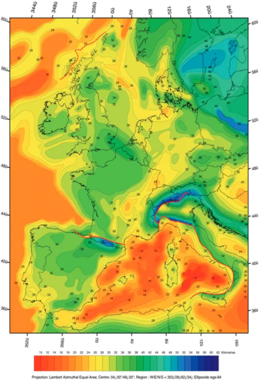
Figure 6. Depth map of Moho discontinuity (2 km contour interval), constructed by integrating published regional maps (after Ref. 27). For data sources see http://comp1.geol.unibas.ch/. Dark lines (solid and stippled) show offsets of the Moho discontinuities
Klaus Tschira Foundation in Heidelberg, Germany. At the same time, the International Lithosphere Program (ILP) recognized TOPO-EUROPE as one of its Regional Coordinating Committees. As such, ILP, Academia Europaea and the Klaus Tschira Foundation financially supported TOPO-EUROPE network meetings promoting the integration of European communities that were active in the field of continental topography research.
TOPO-EUROPE research focuses on the interplay between active tectonics, topography evolution, and related sea-level changes and drainage pattern development. This demands implementation of an integrated observation and analysis strategy, homing in on large-scale changes in vulnerable areas of Europe. Geoprediction in poly-phase deformed and tectonically active systems requires multidisciplinary efforts and, therefore, the interaction and collaboration of researchers covering a broad field of expertise. Among other eminent scientific disciplines, geology, geomorphology, geophysics, geodesy, hydrology, climatology, Figure 7. Moho depth (km). Abbreviations are as follows: A, Apennines; AB, Alboran Basin; AP, Adriatic Promontory; BC, Betic Cordillera; BS, Black Sea; CH, Carpathians; CM, Cantabrian Mountains; D, Dinarides; EB, Edoras Bank; EL, Elbe Lineament; EEP, East European Platform; FB, Focsani Basin, FI, Faeroe Islands; GB, Gulf of Bothnia; HB, Hatton Bank; IAP, Iberian Abyssal Plain; IS, Iapetus Suture; LVM, Lofoten–Vestera˚len margin; MC, Massif Central; NGB, North German Basin; NS, North Sea; OR, Oslo Rift; P, Pyrenees; PB, Pannonian Basin; TS, Tyrrhenian Sea; TTZ, Tesseyre–Tornquist zone; URG, Upper Rhine Graben; VB, Vøring Basin; VT (from Ref. 28)
as well as various fields of geotechnology will be integrated. TOPO-EUROPE addresses several scientific issues of key relevance, such as the (i) 4D develop-ment of Europe’s topography; (ii) source-to-sink relationships to quantify sediment budgets; (iii) quantification of land subsidence in basins and deltas; (iv) quantification of land uplift in orogenic and intraplate domains; (v) quantification of tectonically controlled river evolution; and (vi) effects of climate changes.
Compositional Models mantle lithosphere asthenosphere lower crust Moho crust upper sediments Strength Models Thermal Models
base thermal lithosphere 1300°C isotherm hot cold local geotherm local geotherm Mechanically strong mantle lithosphere Mechanically strong crust (MSC) Base crust (Moho)
Figure 8. From crustal thickness (top left) and thermal structure (top right) to lithospheric strength (bottom left): conceptual make-up of the thermal structure and composition of the lithosphere, adopted for the calculation of 3D strength models
10 20 30 4050 60 70 80 90 10011
0
120
40 44 48 52 56 58 60 62 64 66 70 72 74 78 82 86 90 94
surface heatflow (in mW/m2) thermal age (in Ma) oceanic lithosp. 40 60 80 100 120 140 160 180200 220240 50 70 90 110 55 65 95 105 base thermal lithosphere (in km) base lithosphere from 3D thermal model (b)
(a) thermal input
10°0′0″W 60 °0 ′0 ″N 50 °0 ′0 ″N 40 °0 ′0 ″N 10 °0 ′0 ″N
0°0′0″E 10°0′0″E 20°0′0″E 30°0′0″E 10°0′0″W 0°0′0″E
100 80 120 140 60 80 0 100 160 140 80 60 100 180 140 100 90 80 80 200 140
10°0′0″E 20°0′0″E 30°0′0″E
0°0′0″E 40°0′0″N 10°0′0″E 20°0′0″E 10 °0 ′0 ″W 0°0′0″E 40°0′0″N 10°0′0″E 20 °0 ′0 ″E 40 °0 ′0 ″N 50 °0 ′0 ″N 60 °0 ′0 ″N
Figure 9. Heterogeneity in thermal structure in Europe’s lithosphere and upper mantle. (a) Heterogeneity in surface heat flow. (b) Heterogeneity in depth (km) to the base of the lithosphere inferred from seismic tomography (from Ref. 29)
Progress in quantitative geo-predictions is mainly expected in the domain of data interactive backward and forward modelling. TOPO-EUROPE aims at acquiring high-resolution multidisciplinary data sets, and at closing the loop between observation, reconstruction and process-oriented modelling. TOPO-EUROPE research focuses on the following four interrelated components: (1) geodetic monitoring of the Earth System; (2) geophysical imaging and high-per-formance computing of the deep Earth and lithosphere; (3) geological dynamic topography reconstruction; and (4) process modelling and validation.1 Process modelling and geoprediction require iterative runs of the sequence ‘observation, modelling, process quantification, and optimisation and prediction’. Working together in a concerted effort on common data sets provides the frame for intense cross-fertilization between disciplines and for an optimal dissemination of results.
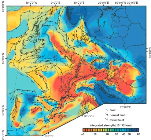
0°0′0″E 10°0′0″E 40 °0 ′0 ″N5 0° 0′ 0″ N 50°0'0"N 10 °0 ′0 ″W 20°0′0″E ~0 85 Integrated strength [10**12 N/m] fault normal fault thrust fault 50 40 30 20 10
Figure 10. Integrated strength map for intraplate Europe (after Ref. 5), showing main structural features (after Refs 3, 30). Colours represent the integrated compressional strength of the total lithosphere. Adopted composition of the upper crust, lower crust and mantle is wet quartzite, diorite and dry olivine, respectively. Rheological rock parameters after Ref. 31. The adopted bulk strain-rate is 10216/s
The TOPO-EUROPE network serves as a vehicle to (i) advance the under-standing of processes controlling topography development and related geohazards; (ii) promote Europe as leader in the field of continental topography research; (iii) provide working opportunities for high-level researchers; (iv) counteract the brain drain to areas outside Europe.
Based on a strong international network of collaborating institutes TOPO-EUROPE is able to tackle outstanding questions pertaining to lithospheric, surface and climate-related processes controlling on-going topography evolution and inherent natural hazards in a variety of geodynamic settings.
The Natural Laboratory Concept: from orogen through platform to continental margin
The TOPO-EUROPE network provides a discussion forum for a multidisciplinary research programme, which operates in a feedback mode between advancement of new numerical modelling concepts and their validation by geological, geophysical and geodetic datasets from selected, well-documented regions covering a wide range of geodynamic settings, the so-called natural laboratories. Each of these natural laboratories is optimally suited to address in a specific geodynamic setting the coupling between tectonic (endogenic) and surface (exogenic) processes and the resulting effects on topography development and inherent geo-hazards.
The TOPO-EUROPE natural laboratories include the post-collisional evolution of the Alps/Carpathians-Pannonian Basin system, the very active Apennines-Tyrrhenian and Aegean-Anatolian system of orogens and back-arc basins, the Caucasus-Levant area of the Arabia-Europe collision zone, the meta-stable Phanerozoic West and Central European Platform, the stable Precambrian East-European Platform, the seismically active Scandinavian passive margin, and the Iberian Peninsula that is rimmed to the North and South by young orogens and to the West and East by passive continental margins (see Table 1). These areas comprise some of the best-documented orogens, sedimentary basins and continental margins worldwide. As such, they are key areas for the development of a new generation of models for ongoing lithospheric deformation and its effects on continental topography devel-opment, both on regional and local scales. As these TOPO-EUROPE projects advance, additional natural laboratories may be selected depending on their merits. Integration of data sets and data handling is vital for efficient transmission of findings through the observation, modelling, process quantification, optimization and prediction chain. In TOPO-EUROPE this can be achieved via a number of connected implementation steps centred on three key cells, namely: (1) creation of new think-tanks for the development and implementation of new conceptual approaches and testing of their viability against the multidisciplinary data sets acquired in the natural laboratories; (2) creation of new Earth System teams
The Alps/Carpathians-Pannonian Basin System
Mountain building and the development of deep
continental basins have created Europe’s weakest crust, prone to major earthquakes, land slides and flooding.
Coupling surface to deep processes for innovative reconstruction and for modeling landform evolution
The Western-Central European Platform
In this region the continent is breaking apart, land is subsiding below sea level and much of Europe’s population infrastructure are concentrated
Multi-scale seismic imaging, monitoring and modeling of environmental (neo-)tectonics
The Aegean-Anatolian and Apennines-Tyrrhenian regions
Seismicity, volcanism and mountain building in the region result from the ongoing collision of the European and African-Arabian plates during the final closing stages of an ocean.
From deep structure to the surface for large-scale process understanding
The Iberian Peninsula Discrimination is needed between deformations induced by plate boundary forces and by deep-seated thermal anomalies
Detailed imaging of the upper mantle (PICASSO-project) and coupling to surface processes
The Scandinavian Continental Margin
Continental rupturing resulted in opening of an oceanic basin and the development of ocean-continent boundary zones rich in hydrocarbons.
Constraining and modeling differential vertical motions and continental break-up mechanisms at ocean-continent boundaries The East-European
Platform
Ancient tectonic analogues of modern geodynamic processes and on-going subsidence of the southern margins.
Imaging the detailed structure of the upper mantle to evaluate the effect of deep mantle processes on reworking of lithosphere The Caucasus and the
Levant
Interaction between continental collision and continental extension
Source-to-Sink reconstructions of uplift, erosion,
sedimentation and differential topography development Analogues, such as the
Andes, the western USA and the Middle East
Regions where processes analogue to those in Europe result in contrasting
topographic expressions
Effects of tectonics/climate interaction on topographic expression
working jointly on unexplored interfaces between existing research activities; and (3) building of information technology cells to optimize integrated data handling, interdisciplinary modelling and software integration.
Integrated approach to selected natural laboratories and analogues For Earth Sciences, analogues provide the key to reconstruct the past and predict the future. The Earth’s natural laboratories provide information on different time slices at a range of spatial scales. An unparalleled opportunity to fill gaps in our understanding of the Solid-Earth system is provided by comparison and quan-titative analysis of high-resolution 4D data cubes generated by the four integrated TOPO-EUROPE components, Monitoring, Imaging, Reconstruction and Process Modelling. Such comparisons can be made at different time and spatial scales.
TOPO-EUROPE operates in an iterative manner with initial models being developed on the base of available data sets and existing concepts. In parallel, new higher resolution data will be acquired in the selected European natural laboratories. Subsequently the initial models will be tested and refined on the basis of the new database.
The TOPO-EUROPE integrative research program is centred on critical regional and continental-scale Earth Science problems in carefully selected natural labora-tories that cover a wide range of geodynamic settings and geo-hazard provinces, for each of which extensive databases are available.
Together, these natural laboratories provide a set of world-class opportunities to probe and quantify the entire range of plate interaction processes, which find expression in presently active tectonics. In these natural laboratories we can obtain the highest possible resolution required to discriminate between endogenic and exogenic Earth processes, required to quantify the coupling between Solid-Earth and surface processes. TOPO-EUROPE’s natural laboratories offer unique key study areas for developing a new generation of models, which can explain ongoing deformation of the lithosphere and its repercussions on continental topography and the human habitat.
As an example of one of the TOPO-EUROPE natural laboratories, the ratio-nale for and the objectives of the TOPO-WECEP Project are presented below. This Project developed out of the EUCOR-URGENT network that addressed, during the years 1999–2007, the Neotectonic and Evolution of the Upper Rhine Graben (http://www.unibas.ch/eucor-urgent).
TOPO – West and Central European Platform (TOPO-WECEP) The meta-stable Phanerozoic West and Central European Platform (WECEP) forms the foreland of the Alpine-Carpathian and Pyrenean orogens and provides a natural laboratory for analysing the response of an intraplate domain to collision-related and
(ECRIS), inversion of Mesozoic tensional basin and upthrusting of basement blocks, lithospheric folding controlling uplift of the Vosges-Black Forest arch and the Armorican Massif, as well as subsidence of the North Sea Basin, and thermal doming of the Rhenish Massif and the Massif Central.3,4 These defor-mations had severe repercussions on the development of the topography and drainage systems, particularly during the last 20 million years.
Seismicity and stress indicator data, combined with geodetic and geomor-phologic observations, demonstrate that the WECEP is presently deforming at strain rates of up to 1 mm/yr.5This has major implications for the assessment of its natural hazards and environmental degradation. The TOPO-WECEP Project addresses the relationship between deeper lithospheric processes controlling neotectonics, and surface processes that affect the WECEP, with a special emphasis on tectonically induced topography. The objective is to quantify the contribution of Alpine collisional and Atlantic ridge push stresses, as well as of the loads exerted by convective asthenospheric instabilities to the ongoing intraplate deformation of the WECEP, and to assess their impact on the evolution of the topography and drainage systems and related natural hazards.
Rationale
During the last decade, and under the auspices of the World Stress Map project and the Origin of Sedimentary Basins Task Force, both sponsored by the International Lithosphere Program (ILP), new databases were developed for the present-day stress field and ongoing vertical crustal motions of the WECEP. On the basis of these, close links could be established between the stress field, the Neogene to Quaternary intraplate deformation, and the distribution of seismic activity and topography (Figure 11). The present-day stress field of the WECEP6was successfully modelled by taking Alpine collisional coupling and Atlantic ridge-push forces into account.7–9Furthermore, acquisition of high-quality tomographic data10 permitted imaging of the thermal structure of the sub-lithospheric mantle beneath the WECEP, revealing that, in the ECRIS area, low-velocity anomalies occur immedi-ately above the 410 km discontinuity. These are interpreted as mantle plume heads from which secondary ‘baby-plumes’ intermittently welled up,4,11 as currently evident beneath the Massif Central12 and the Rhenish Massif.13
There is increasing evidence that the WECEP lithosphere responded to the build-up of intraplate compressional stresses during the latest Cretaceous and Paleogene by reactivation of pre-existing crustal discontinuities controlling basin inversion and upthrusting of basement blocks. By contrast, during the Neogene, it
partly responded by lithospheric folding,14,15as evidenced by the Plio-Pleistocene subsidence acceleration of the North Sea Basin and contemporaneous uplift of the Fennoscandian Shield.16,17In this context, it is noteworthy that studies on mechani-cal properties of Europe’s lithosphere reveal a direct link between its thermo-tectonic age and bulk strength, whereas inferences from P- and S-wave tomography and thermo-mechanical modelling point to pronounced weakening of the lithosphere in the area of the Massif Central and Rhenish Massif, owing to high upper mantle temperatures5 (see also Figure 12). Uplift of the Rhenish Massif by as much as 250 m during the last 0.8 million years18,19 can be attributed to the load of an impinging baby-plume and related thermal thinning of the lithosphere.4,20
The evolution of ECRIS, and particularly the progressive uplift of the Massif Central, the Vosges Black Forest Arch and the Rhenish and Bohemian Massifs during the last 20 million years had severe repercussions on the development of
10°0′0″W 0°0′0″E 10°0′0″E 20°0′0″E 30°0′0″E
60 °0 ′0 ″N 60°0′0″N 50°0 ′0 ″N 40°0 ′0 ″N 50°0 ′0 ″N 10°0 ′0 ″W 0°0'0″E 10°0'0″E 20°0'0″E fault normal fault thrust fault 1 10 Integrated strength [10**10 N/m] Earthquake epicentre 200 100 60 40 20
Figure 11. Spatial comparison of crustal seismicity and integrated crustal strength. Earthquake epicentres from the NEIC data centre (NEIC, 2004), queried for magnitude .2 and focal depths ,35 km
the WECEP drainage system.4,21 Parts of this drainage system are prone to repeated catastrophic flooding (e.g. Northern Germany and Poland), and thus are highly susceptible to neotectonic deformations (see Fig. 13).22
In the context of the EUCOR-URGENT Project, assessment of crustal and lithospheric controls on the neotectonic deformation of the Alpine foreland was the focus of the European HPRN ENTEC program that integrated geological,
geophysical, geodetic, geomorphologic, and geotechnological approaches.23
Figure 12. Seismicity (red dots) of the Rhine rift system (courtesy EUCOR-URGENT)
Results of this pioneering program show that monitoring of the subsurface by 3D seismics, combined with satellite-based geodetic monitoring of horizontal and vertical crustal motions, permits us to extend the record of neotectonic activity and related topography development into the domain of 100,000 to a few million years, thus building up a large database for validation of process modelling. This approach will be further refined by TOPO-WECEP that addresses such specific areas and their inherent neotectonic phenomena as:
> neotectonics of the Rhine-Rhoˆne rift system,
> subsidence of the North German-Polish Basin and vulnerability of its coastal areas,
> seismicity and neotectonic deformation of the Armorican Massif, > neotectonic uplift of the Bohemian Massif,
> neotectonics of the British Isles and their shelves.
Specific TOPO-WECEP projects
LABTOP: Lithosphere-Asthenosphere Boundary Topography in the WECEP area
(coordinator: U. Achauer, IPG Strasbourg, France).
MOMODE: Monitoring and Modelling Deformation of the WECEP area
(coordinator: B. Heck, University Karlsruhe, Germany). (E)
(C)
(A)
Figure 13. Rheological cross-sections across the main elements of ECRIS. (E) Roer Valley and Hessian Grabens; (C) central part of the URG; (A) Bresse Graben
GFZ Potsdam, Germany).
VEMTOP: Vertical Motion and Topography of the WECEP (coordinator: R. van
Balen, VU University Amsterdam, The Netherlands).
ECVP: European Cenozoic Volcanic Province – Plume-like instabilities in the Upper Mantle (coordinator: M. Wilson, Leeds University, UK). PALMAP: Cenozoic palaeogeographic evolution of the WECEP area (coordinator:
J.-P. Berger, University Fribourg, Switzerland).
RIVER: Response of WECEP river systems to Neogene and Quaternary
climate changes and tectonics (coordinator: Ph. Gibbard, Cambridge University, UK).
SEITECT: Seismotectonics and present Stress Field of the WECEP (coordinator: O. Heidbach, University Karlsruhe, Germany).
GEOTHERM: Geothermal energy potential of the WECEP, thermal tomography (coordinator J.-D. van Wees, TNO–NITG Utrecht, The Netherlands).
The TOPO-WECEP Project was launched in March 2008 during a EUCOR-URGENT symposium held at Mt. St. Odile near Strasbourg and is coordinated by J.-D. Van Wees (TNO-NITG Utrecht) and A. Lankreijer (VU University Amsterdam). For further information on TOPO-WECEP and a description of its sub-project go to: http://www.topo-wecep.eu.
Investment required
The modern Earth System approach requires a comprehensive integration of existing databases, with the capacity for expanding them to allow for storage and exchange of new data collected during the growth of the TOPO-EUROPE pro-gram. Unification and coupling of existing modelling techniques is required to achieve full integration of what are currently discipline-oriented approaches and to expand them to ‘next generation’ 3D applications. Furthermore, for the quantification of Earth processes, flexible data exchange is required for ‘feedback loops’ at the interface between databases and modelling tools. Consequently, major investments in Information Technology are called for to expand existing computer hardware and software facilities.
Significant added value will also be realized by developing a Centre for integrated Solid Earth interpretation, validation and modelling as the ‘backbone’ for Coupled Deep Earth and Surface Processes. Such a development will bring together multidisciplinary researches and a hitherto non-existent array of inte-grated hardware and software, dedicated to ‘streamlined’ and consistent analysis of large 3D data sets.
Training young scientists in such a multidisciplinary research environment is an investment in the future research capacity of European Earth Sciences.
Funding of TOPO-EUROPE activities
In early 2008, the European Science Foundation (ESF) recognized TOPO-EUROPE as one of its large-scale European collaborative research initiatives (EUROCORES). In response to the ESF call for proposals, 42 outline proposals were submitted, of which 22 were invited to submit full proposals. After international peer-review the following ten collaborative research projects (CRPs) were selected for funding by the ESF EUROCORES TOPO-EUROPE, amounting to a total of h13.5 million, cover-ing about 60 PhD and post-doc positions (http://www.esf.org/activities/eurocores/ programmes/topo-europe.html):
VAMP: Vertical Anatolia Movements Project (coordinator: M. Strecker,
University Potsdam, Germany).
TOPO-4D: Mantle forcing of Earth surface evolution in Europe and the Mediterranean: From Past to Present (coordinator: W. Spakman, Utrecht University, The Netherlands).
TOPOALPS: The Topographic History of the Alps and its Tectonic and Climatic Drivers (coordinator: S. Willett, ETH-Zu¨rich, Switzerland).
THERMO-EUROPE:
Coupled climatic/tectonic forcing of European topography revealed through thermochronometry (coordinator: P. van der Beek,
University Grenoble, France).
RESEL-GRACE: Refined European sea level estimations by combining altimetry, tide gauges, hydrographic and other data sets with improved regional GIA modelling and tailored regional GRACE gravity field models (coordinator: J. Kusche, GFZ Potsdam, Germany).
TOPOMED: Plate reorganization in the western Mediterranean: Lithospheric causes and topographic consequences (coordinator: M. Wortel, Utrecht University, The Netherlands).
PYRTEC: Spatial and temporal coupling between tectonics and surface processes during lithosphere inversion of the Pyrenean-Cantabrian mountain belt (coordinator: R. Huismans, University Bergen, Norway).
TopoScandiaDeep: Searching for the origin of the topography of the Scandes (coordinator: V. Maupin, University Oslo, Norway).
SedyMONT: Time-scales of sediment dynamics and topographic change in mountain landscapes (coordinator: F. Schlunegger, University Bern, Switzerland). SourceSink: Integrated natural hazard assessment through the quantification of
mass transfer from mountain ranges to active sedimentary basins (coordinator: P. Andriessen, VU University Amsterdam, The Netherlands).
ESF support has significantly strengthened the TOPO-EUROPE network. Nevertheless, it must be realized that the ESF EUROCORES financial support
EUROCORES funding and will have to seek financial support from other sources such as National Science Foundations, Research Councils or Ministries. Moreover Universities, National Academies and Geological Surveys can strengthen the TOPO-EUROPE network by contributing existing research positions. In this respect it ought to be kept in mind that financing by the ESF EUROCORES is just one vehicle to advance the TOPO-EUROPE Project. For example the Spanish Ministry of Science and Education supports the TOPO-IBERIA Project with h4.5 million, which also benefits from the ESF EURO-CORES PYRTEC Project. The next phase of research on coupled Deep Earth and surface processes will be the topic of the forthcoming TOPO-EUROPE meeting jointly organized by Academia Europaea, ESF and ILP in the Villa Bosch of the Klaus Tschira Foundation in Heidelberg, 15–17 October 2009.
References
1. S. A. P. L. Cloetingh, P. A. Ziegler, P. J. F. Bogaard, P. A. M. Andriessen, I. M. Artemieva, G. Bada, R. T. Balen, F. Beekman, Z. Ben-Avraham, J. P. Brun, H. P. Bunge, E. B. Burov, R. Carbonell, C. Facenna,
A. Friedrich, J. Gallart, A. G. Green, O. Heidbach, A. G. Jones, L. Matenco, J. Mosar, O. Oncken, C. Pascal, G. Peters, S. Sliaupa, A. Soesoo, W. Spakman, R. A. Stephenson, H. Thybo, T. Torsvik, G. de Vicente and F. Wenzel, M. J. R. Wortel and Topo-Europe-Working-Group (2007) TOPO-EUROPE: The geoscience of coupled deep Earth-surface processes. Global and Planetary Change, 58, 1–118.
2. S. A. P. L. Cloetingh and T. G. M. Cornu (eds) (2005) Neotectonics and quaternary fault-reactivation in Europe’s intraplate lithosphere. Quaternary Science Reviews, 24, 235–508.
3. P. Dezes, S. M. Schmid and P. A. Ziegler (2004) Evolution of the European Cenozoic Rift System: interaction of the Alpine and Pyrenean orogens with their foreland lithosphere. Tectonophysics, 389, 1–33.
4. P. A. Ziegler and P. Dezes (2007) Cenozoic uplift of Variscan Massifs in the Alpine foreland: timing and controlling mechanisms. Global and Planetary Change, 58, 237–269.
5. S. Cloetingh, P. A. Ziegler, F. Beekman, P. A. M. Andriessen, L. Matenco, G. Bada, D. Garcia-Castellanos, N. Hardebol, P. Dezes and D. Sokoutis (2005) Lithospheric memory, state of stress and rheology: neotectonic controls on Europe’s intraplate continental topography. Quaternary Science Reviews, 24, 241–304.
6. B. Muller, V. Wehrle, H. Zeyen and K. Fuchs (1997) Short-scale variations of tectonic regimes in the western European stress province north of the Alps and Pyrenees. Tectonophysics, 275, 199–219.
7. M. Golke, S. Cloetingh and D. Coblentz (1996) Finite-element modelling of stress patterns along the Mid-Norwegian continental margin, 62 degrees to 68 degrees N. Tectonophysics, 266, 33–53.
8. P. A. Ziegler, G. Bertotti and S. A. P. L. Cloetingh (2002) Dynamic processes controlling foreland development – the role of mechanical (de)coupling of orogenic wedges and forelands. In: G. Bertotti, K. Schulmann, S. A. P. L. Cloetingh (eds) Continental Collision and the Tectono-Sedimentary Evolution of Forelands. EGU Stephan Mueller Special Publication, 1, pp. 17–57. 9. J. Guimera, R. Mas and A. Alonso (2004) Intraplate deformation in the NW
Iberian Chain: Mesozoic extension and Tertiary contractional inversion. Journal of the Geological Society, 161, 291–303.
10. S. Goes, R. Govers and P. Vacher (2000) Shallow mantle temperatures under Europe from P and S wave tomography. Journal of Geophysical Research-Solid Earth, 105, 11153–11169.
11. P. Dezes, S. M. Schmid and P. A. Ziegler (2005) Reply to comments by L. Michon and O. Merle on ‘Evolution of the European Cenozoic Rift System: interaction of the Alpine and Pyrenean orogens with their foreland lithosphere’ by P. Dezes, S. M. Schmid and P. A. Ziegler. Tectonophysics 389 (2004) 1–33. Tectonophysics, 401, 257–262.
12. M. Granet, G. Stoll, J. Dorel, U. Achauer, G. Poupinet and K. Fuchs (1995) Massif-Central (France) – new constraints on the geodynamical evolution from teleseismic tomography. Geophysical Journal International, 121, 33–48. 13. J. R. R. Ritter, M. Jordan, U. R. Christensen and U. Achauer (2001)
A mantle plume below the Eifel volcanic fields, Germany. Earth and Planetary Science Letters, 186, 7–14.
14. S. Cloetingh, F. Beekman, P. A. Ziegler, J.-D. Van Wees and D. Sokutis (2008) Post-rift compressional reactivation potential of passive margins and extensional basins. In: H. Johnson, A. G. Dore´, R. W. Gatliff, R. E. Holdsworth, E. R. Lundin, J. D. Ritchie (eds) The Nature and Origin of Compressive Margins (Geological Society of London, Special Publications), pp. 27–69. 15. S. Cloetingh, E. Burov and A. Poliakov (1999) Lithosphere folding:
primary response to compression? (from central Asia to Paris basin). Tectonics, 18, 1064–1083.
16. S. Cloetingh and E. B. Burov (1996) Thermomechanical structure of European continental lithosphere: constraints from rheological profiles and EET estimates. Geophysical Journal International, 124, 695–723. 17. J. D. vanWees and S. Cloetingh (1996) 3D Flexure and intraplate
compression in the North Sea Basin. Tectonophysics, 266, 343–359. 18. R. F. Houtgast and R. T. van Balen (2000) Neotectonics of the Roer Valley
Rift System, the Netherlands. Global and Planetary Change, 27, 131–146. 19. W. Meyer and J. Stets (2002) Pleistocene to Recent tectonics in the Rhenish
Massif (Germany). Netherlands Journal of Geosciences, 81, 217–221. 20. D. Garcia-Castellanos, S. Cloetingh and R. Van Balen (2000) Modelling the
middle pleistocene uplift in the Ardennes-Rhenish Massif: thermo-mechanical weakening under the Eifel? Global and Planetary Change, 27, 39–52. 21. W. Sissingh (2006) Syn-kinematic palaeogeographic evolution of the West
Zeitschrift Der Deutschen Gesellschaft Fur Geowissenschaften, 159, 117–122. 23. S. A. P. L. Cloetingh and T. Cornu (2005) Surveys on environmental
tectonics. Quaternary Science Reviews, 24, 235–240.
24. S. Cloetingh, T. Cornu, P. A. Ziegler and F. Beekman, and ENTECWorking Group (2006) Neotectonics and intraplate continental topography of the northern Alpine Foreland. Earth-Science Reviews, 74, 127–196.
25. I. M. Artemieva, H. Thybo and M. K. Kaban (2006) Deep Europe today: geophysical synthesis of the uppermantle structure and lithospheric processes over 3,5 Ga. In: D. Gee, R. A. Stephenson (eds) European Lithosphere Dynamics. Geological Society, London, Memoir, 32, 11–41.
26. W. Spakman, S. van der Lee and R. van der Hilst (1993) Travel-time tomography of the European Mediterranean mantle down to 1400 km. Physics of the Earth and Planetary Interiors, 79, 3–74.
27. P. De`zes and P. A. Ziegler (2004) Moho depth map of Western and Central Europe. EUCOR-URGENT home page (http://www.unibas.ch/eucor-urgent). 28. M. Tesauro, M. K. Kaban and S. A. P. L. Cloetingh (2008) EuCRUST-07: A
new reference model for the European crust. Geophysical Research Letters, 35. 29. N. J. Hardebol, F. Beekman, S. Cloetingh, M. Tesauro and P. A. Ziegler
(2009) Spatial strength variations in Europe’s lithosphere: inferences from 3-D Rheological modeling. Tectonophysics, submitted.
30. P. A. Ziegler (1988) Evolution of the Arctic-North Atlantic and the Western Tethys. Memoir 198 pp, American Association of Petroleum Geologists. 31. N. L. Carter and M. C. Tsenn (1987) Flow properties of continental
lithosphere. Tectonophysics, 136, 27–63.
About the Authors
Sierd Cloetingh is Royal Netherlands Academy Professor of Earth Sciences at VU University Amsterdam. He has published more than 250 papers in interna-tional peer-reviewed journals and has been promoter of 55 PhD students of 18 different nationalities. He has served the Earth Science community in various functions, including Presidency of the European Geophysical Society. He is currently the President of the International Lithosphere Programme, Editor-in-Chief of the International Journal Global and Planetary Change and Chairman of the Scientific Committee of the European Large Scale Collaborative Research Programme (EUROCORES) TOPO-EUROPE. He received honorary doctorates from four European universities and numerous honours and awards, including the Stephan Mueller Medal of the European Geosciences Union, Fellow and Hon-orary Fellow of the American Geophysical Union and the Geological Society of America and the Leopold von Buch Medal of the German Geological Society. He is a member of the Royal Netherlands Academy of Arts and Sciences and Foreign
member of the Royal Norwegian Academy of Sciences, the Royal Danish Academy of Sciences, the Heidelberg Academy and the Bavarian Academy. In 2006 he was distinguished as Chevalier de Legion d’Honneur for his contribu-tions to science and European scientific cooperation in research and education. He was elected member of Academia Europaea in 1994 and served Academia Europaea as Chair of the Earth and Marine and Earth and Cosmic Sciences Sections. In 2008 he was elected by the Council as Vice-President of Academia Europaea. In 2009 he was appointed as member of the ERC Scientific Council. Peter A. Ziegler is an Emeritus Professor at the University of Basel, Switzer-land. In 1955, after receiving a PhD in geology from the University of Zurich, he joined the petroleum industry. After working in Israel, Madagascar and Algeria, in 1958 he joined Shell Canada in Calgary. In 1970 he transferred to Shell International in the Netherlands where he was engaged in worldwide exploration activities. After his retirement in 1988, he joined the University of Basel as a honorary lecturer and later as Professor for Global Geology. He has been awarded honorary doctorates from Moscow State University and the Technical University Delft. He has published widely on the evolution of sedimentary basins, intraplate tectonics and the geological evolution of Europe. He initiated and coordinated the EUCOR-URGENT Project.
He is the recipient of numerous honours and awards, including the Foumarier medal of the Belgian Geological Society, the van Waterschot van der Gracht medal of the Netherlands Geological and Mining Society, the William Smith medal of the London Geological Society, the Neville George medal of the Glasgow Geological Society, the Stephan Mu¨ller medal of the European Geosciences Union, the Leopold von Buch medal of the German Geological Society and the Leonidovici Kaptsa medal of the Russian Academy of Natural Sciences. He is a member of the Royal Netherlands Academy of Sciences, the Polish Academy of Arts and Sci-ences, the Russian Academy of Natural Sciences and the Academia Europaeana and is a honorary member of the London Geological Society, the American Association of Petroleum Geologists and the Polish Geological Society.