Abstract
The development of the Bakhuis ultrahigh-temperature (UHT) granulite belt, northwestern Suriname, is discussed in the light of an updated geological framework for the Guiana Shield. In the Shield Archean basement is present only in the far western and eastern parts, i.e. Imataca (Venezuela) and south Amapá / northwestern Pará (Brazil). The huge Shield region in between is the result of Paleoproterozoic growth and reworking, during a Rhyacian “Main Transamazonian event” (2.26-2.08 Ga) producing tonalite(TTG)-greenstone belts and a subsequent granitic suite, and a Late-Rhyacian to Orosirian “Late Transamazonian event” (2.07 - 1.93 Ga) characterized by granulite belts and synchronous magmatism.
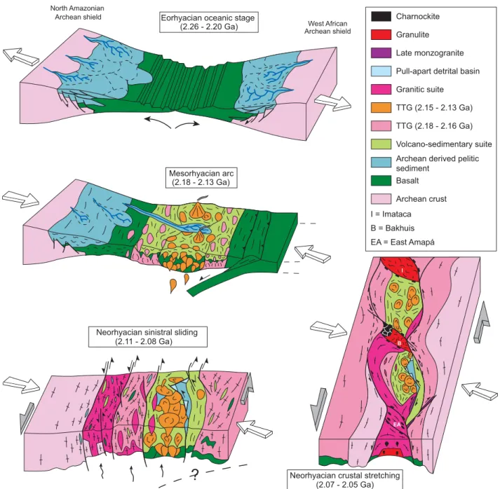
For the Main Transamazonian event, the timing and geometry of the greenstone belts and TTG magmatism are defined in terms of plutono-volcanic pulses occuring between 2.18 Ga and 2.13 Ga. They are interpreted as the result of progressive consumption of juvenile oceanic crust during a tectonic stage (D1) witnessing N-S convergence of north-Amazonian and west-African Archean blocks, with southward subduction. The subduction is reflected in an
apparent diachronous island-arc accretion in the eastern part of the Guiana Shield, with a 2.15-2.13 Ga central TTG domain located between northern and southern TTG domains dated at 2.18-2.16 Ga. The D1 tectonothermal stage is closely associated with that major stage of plutonism, as shown by low-pressure thermal aureoles and gravity-driven deformation.
The transition from N-S frontal plate convergence to oblique NE-SW convergence with major sinistral shear marks the onset of a later stage (D2) of the Main Transamazonian event, at ca. 2.10 Ga. The production of dominant granite magmatism and the formation of pull-apart basins at 2.11-2.08 Ga witness a first part of this event (D2a).
The Late-Transamazonian event leads to further structuring of the TTG-greenstone belts and the granitic suite during prolonged sinistral wrenching (D2b). At a regional scale, our new Shield compilation map highlights the trends of the TTG-greenstone belts, which display an overall “pinch and swell” structuring, with two E-W continental-scale boudins limited by three granulite domains, Imataca, Bakhuis and eastern Amapá. The Bakhuis belt shows granulite-facies metamorphism under UHT and
granulite belt (Suriname):
II. implications for late
Transamazonian crustal stretching
in a revised
Guiana Shield framework
La ceinture de granulites d’ultra-haute température des Monts Bakhuis (Suriname) :
II. implications en termes d’étirement crustal tardi-transamazonien argumenté dans le cadre
d’un schéma structural révisé du Bouclier guyanais
Jean-Michel LAFON
(3)Didier LAHONDÈRE
(1)Philippe ROSSI
(1)Alain COCHERIE
(1)Catherine GUERROT
(1)Alain POTREL
(4)Géologie de la France, 2003, n° 2-3-4, 207-230, 3 fig.
Mots clés : Paléoprotérozoïque, Granulite, Orogène transamazonien, Suriname, Bouclier guyanais. Key words: Paleoproterozoic, Granulite, Transamazonian orogeny, Suriname, Guiana Shield.
(1) brgm, 3 avenue Claude-Guillemin, BP 6009, 45060 Orléans, cedex 2, France. (2) ONDEO Nalco Europe, Leiden, The Netherlands.
(3) Pará-Iso, Centro de Geociências, UFPA, Belém, Brasil.
(4) Earth Sciences department, Memorial University of Newfoundland, Canada. * corresponding author. E-mail:c.delor@brgm.fr
near-UHT conditions. This granulite metamorphism and associated charnockite magmatism were dated at 2.07-2.05 Ga. We interpret both continental-scale boudinage and UHT metamorphism in terms of late-Transamazonian crustal stretching, as the result of prolonged sinistral shearing (D2b). The exceptional, UHT, conditions of the Bakhuis metamorphism require a mantle-derived thermal perturbation, situated probably in a zone of maximum crustal stretching. The counterclockwise prograde P-T path of the metamorphism witnesses a very high thermal gradient during burial, in response to mantle upwelling, while subsequent isobaric to near-isobaric cooling reflects the progressive return to a normal geothermal gradient, in a moderately thickened crust.
In eastern Amapá, 2.06-2.05 Ga charnockite magmatism is also interpreted as the result of late-Transamazonian crustal stretching. In Imataca, Paleoproterozoic granulitic metamorphism might be connected to the same mantle-driven thermal regime.
There is evidence for even younger Late-Transamazonian high-grade metamorphism and magmatism, as shown by granulite-facies metamorphism poorly constrained at about 2.0 Ga and charnockite magmatism at 1.97-1.93 Ga in the central part of the Shield. At the scale of the Guiana Shield the belt of 2.01-1.96 Ga old acid volcanics and hypabyssal granites (pro
parte the so-called Uatumã) shows the same veering as the
nearby TTG-greenstone belts. This, and the presence of open folding, suggest that this acid magmatic belt has suffered N-S to NE-SW regional shortening during the waning stages of the Late-Transamazonian event.
In conclusion, the Transamazonian tectonometamorphic continuum associated to oblique plate convergence (D2) may have been a rather protracted multi-stage event. D2 metamorphism culminated with the formation of granulite belts, and more specifically with UHT metamorphism in the Bakhuis belt at 2.07-2.05 Ga, as the result of Late-Transamazonian crustal stretching, enhanced by prolonged sinistral shearing of early formed Rhyacian crust.
Résumé
Ce travail discute la formation de la ceinture de granulites d’ultra-haute température (UHT) des Monts Bakhuis à la lumière d’un schéma géologique actualisé du Bouclier Guyanais. La présence d’un socle archéen est reconnu uniquement dans les secteurs les plus occidentaux de l’Imataca (Vénézuela), et les plus orientaux du sud Amapá / nord-ouest du Pará (Brésil). Entre ces deux extrêmes secteurs, la croissance crustale et les processus thermo-tectoniques d’âge paléoprotérozoïque sont présentés comme l’aboutissement d’un « événement transamazonien majeur » Rhyacien (2,26–2,08 Ga) ayant produit des ensembles TTG-ceintures de roches vertes, ainsi qu’une suite granitique et
d’un « événement tardi-transamazonien » tardi-Rhyacien à Orosirien (2,07–1,93 Ga) caractérisé par la formation de ceintures de granulites et un magmatisme de même âge.
Au sein de l’événement transamazonien majeur, la chronologie et la géométrie du magmatisme TTG et des ceintures de roches vertes, sont déclinées en termes de pulsations plutono-volcaniques entre 2,18 Ga et 2,13 Ga. Ce magmatisme est interprété comme le résultat de la destruction progressive d’une croûte juvénile océanique pendant un épisode tectonique D1 témoignant de la convergence N-S des blocs archéens nord-amazonien et ouest-africain, et d’une zone de subduction majeure à pendage sud. A l’est du Bouclier Guyanais, la croissance des ensembles TTG-ceintures de roches vertes est diachrone avec mise en évidence d’un domaine central d’accrétion d’âge 2,15-2,13 Ga, entre deux domaines de TTG nord et sud d’âge 2,18-2,16 Ga. Associées à ce stade majeur de plutonisme, des auréoles thermiques et des déformations gravitaires caractérisent l’épisode thermo-tectonique D1.
A 2,10 Ga, la transition des directions de convergence de plaques, de N-S (frontale) à NE-SW (oblique) se traduit par un stade de déformation sénestre majeur, qui marque le début d’un épisode thermo-tectonique D2 plus tardif au sein de l’événement Transamazonien majeur. Un magmatisme granitique dominant ainsi que la formation de bassins
pull-apart à 2,11-2,08 Ga (événement D2a) lui sont associés.
L’événement transamazonien tardif est responsable de la structuration ultérieure des ensembles TTG-ceintures de roches vertes et de la suite granitique, au cours d’un stade de coulissage sénestre prolongé (D2b). A l’échelle régionale, notre nouvelle carte synthétique du Bouclier Guyanais met en exergue les directions structurales des ceintures TTG-roches vertes, en soulignant la géométrie d’ensemble de domaines pincés et élargis (« pinch and swell »), correspondant à deux « boudins » E-W d’échelle continentale encadrés par trois domaines granulitiques : Imataca, Bakhuis et Est-Amapá. D’un intérêt spécifique pour notre étude, la ceinture des Monts Bakhuis révèle un métamorphisme granulitique atteignant des conditions de UHT. Ce métamorphisme granulitique et un magmatisme charnockitique associé sont datés à 2,07-2,05 Ga. Nous interprétons le boudinage d’échelle continentale et le métamorphisme UHT en termes d’étirement crustal D2b tardi-transamazonien, résultant d’un contexte prolongé en cisaillement sénestre. Nous proposons que le métamorphisme des trois domaines granulitiques, et de façon plus spécifique le métamorphisme UHT des Monts Bakhuis tardi-rhyacien, résultent d’une perturbation thermique tardi-transamazonienne de nature mantellique dans les zones d’étirement crustal maximum. Le trajet Pression-Température anti-horaire du métamorphisme granulitique des Monts Bakhuis témoigne d’un gradient thermique très élevé au cours d’un stade d’enfouissement, en
réponse à une remontée mantellique. Le refroidissement isobare reflète le retour progressif à un gradient géothermique normal, au sein d’une crôute affectée par un épaississement crustal modéré.
A l’est de l’Amapá, la présence d’un magmatisme charnockitique à 2,06-2,05 Ga est aussi interprétée comme le résultat de cet étirement crustal tardi-transamazonien. Dans le secteur Imataca, le métamorphisme granulitique pourrait être lié au même régime thermique activé par une perturbation mantellique.
Par ailleurs, il existe des signes de métamorphisme et magmatisme encore plus jeunes dans la partie centrale du bouclier, comme en témoignent les évidences de métamorphisme granulitique mal contraint vers 2,0 Ga et de magmatisme charnockitique daté à 1,97-1,93 Ga. De plus, à l’échelle du bouclier Guyanais, la ceinture volcano-plutonique acide datée à 2,01-1,96 Ga (pro parte « Uatumã ») montre des virgations de directions identiques à celles des ceintures TTG-roches vertes contiguës. Ce constat et l’observation de plis ouverts au sein des formations volcaniques, suggèrent qu’au moins une partie de ce magmatisme acide a été impliqué dans un raccourcissement régional de direction N-S à NE-SW durant les stades terminaux de faible amplitude de l’événement tardi-transamazonien.
En conclusion, le continuum thermo-tectonique transamazonien associé au stade de convergence oblique (D2) semble avoir été un événement relativement étalé dans le temps, et caractérisé par plusieurs étapes. Le métamorphisme D2 a atteint son paroxysme avec la formation de domaines granulitiques, et de façon spécifique avec le métamorphisme UHT des Monts Bakhuis daté à 2,07-2,05 Ga. La formation de ces domaines granulitiques résulte, à l’échelle continentale, de l’étirement de la croûte précoce rhyacienne au tardi-transamazonien, sous l’effet prolongé d’un contexte cisaillant sénestre.
Resumo
Esse trabalho discute a formação da faixa granulítica de ultra-alta temperatura (UHT) dos Montes Bakhuis, NW do Suriname, à luz de um esquema geológico atualizado do Escudo das Guianas. A presença de um embasamento arqueano é reconhecida apenas nos setores mais ocidentais do Imataca (Venezuela) e mais orientais, no sul do Amapá / noroeste do Pará (Brasil). A extensa área entre esses dois extremes é resultado de crescimento crustal e retrabalhamento paleoproterozóicos durante um “Evento Transamazônico Principal” riaciano (2,26–2,08 Ga), produzindo associações TTG-greenstone belts e, em seguida, uma suíte granítica e de um “Evento Tardi-Transamazônico”, tardi-riaciano a orisiriano (2,07-1,93 Ga), caracterizado pela formação de faixas granulíticas e de um magmatismo contemporâneo.
Para o Evento Transamazônico Principal, a cronologia e a geometria do magmatismo TTG e das seqüências greenstones são interpretadas em termos de pulsos plutono-vulcânicos entre 2,18-2,13 Ga. Este magmatismo é considerado como o resultado da destruição progressiva de uma crosta juvenil oceânica durante um episódio tectônico D1, testemunhando a convergência N-S dos blocos arqueanos norte amazônico e oeste africano, e a existência de uma zona de subducção com vergência para sul. Na porção oriental do Escudo das Guianas, o crescimento dos terrenos TTG-greenstones ocorre de forma diacrônica com um domínio central de acresção com idade de 2,15-2,13 Ga entre dois domínios de TTG norte e sul com idades de 2,18-2,16 Ga. A estreita associação do episódio termo-tectônico D1 com esse importante episódio plutónico, é demonstrada pela presença de auréolas térmicas e deformações gravitarias.
A mudança de convergência frontal de placas de direção N-S para uma convergência obliqua de direção NE-SW se traduz por um estágio de deformação sinistral, o qual marca o início de um episódio termo-tectônico D2 mais tardio, do Evento Transamazônico Principal a 2,10 Ga. Um magmatismo predominantemente granítico e a formação de bacias pull apart a 2,11-2,08 Ga estão associados às primeiras etapas deste estágio (D2a).
O Evento Tardio Transamazônico é responsável pela estruturação posterior dos terrenos TTG-greenstones e da suíte granítica, durante um estágio de deformação sinistral prolongado (D2b). Em escala regional, o novo mapa sintético do Escudo das Guianas enfatiza as direções estruturais das associações TTG-greenstones, e a geometria dos domínios
pinch and swell, correspondendo a dois boudins E-W de
escala continental, bordejados por três domínios granulíticos (Imataca, Bakhuis e Leste-Amapá). A faixa dos Montes Bakhuis revela um metamorfismo granulítitico que alcança condições UHT ou próximas a estas condições. Esse metamorfismo granulítico e o magmatismo charnoquítico associado foram datados em 2,07-2,05 Ga. O “boudinage” em escala continental e o metamorfismo UHT são interpretados em termos de estiramento crustal D2b tardi-transamazônico, como resultado de um episódio em cisalhamento sinistral durante um período prolongado. As condições excepcionais do metamorfismo UHT tardi-riaciano dos Montes Bakhuis requere uma perturbação térmica de natureza mantélica, em uma zona de estiramento crustal máximo. As trajetórias Pressão–Temperatura anti-horárias do metamorfismo granulítico dos Montes Bakhuis retratam um gradiente térmico muito elevado durante um estágio de soterramento, em resposta a uma subida mantélica. O subseqüente resfriamento isóbaro ou quase isóbaro reflita uma volta progressiva a um gradiente geotérmico normal, de uma crosta com espessamento crustal moderado.
No leste do Amapá, a presença de um magmatismo charnoquítico a 2,06-2,05 Ga é também interpretado como
o resultado deste episódio de estiramento crustal tardi-transamazônico. No setor do Imataca, o metamorfismo granulítico poderia também ser ligado ao mesmo regime térmico, ativado por perturbação mantélica.
Existem evidências de um episódio metamórfico transamazônico ainda mais tardio na porção central do Escudo, identificado por gnaisses granulíticos, com idade mal definida em torno de 2,0 Ga e um magmatismo charnoquítico datado em torno de 1,97-1,93 Ga. Na escala do Escudo das Guianas, a faixa vulcano-plutônica félsica datada a 2,01-1,96 Ga (pro-parte Uatumã) mostra virgações de direções idênticas àquelas das associações TTG-greenstones vizinhas. Essa constatação e a observação de dobras abertas dentro das formações vulcânicas sugere que pelo menos parte deste magmatismo félsico foi envolvida em um episódio de encurtamento regional de direção N-S a NE-SW, durante os estágios finais de baixa amplitude do evento tardi-transamazônico. Em conclusão, o continuum termo-tectônico transamazônico associado ao estágio obliqua (D2) parece ter constituído um evento relativamente espalhado no tempo e caracterizado por várias etapas. O metamorfismo D2 atingiu o seu paroxismo com a formação de domínios granulíticos, em particular, com o evento metamórfico de UHT dos montes Bakhuis, datados em 2,07-2,05 Ga. A formação desses domínios granulíticos resulta, em escala continental do estiramento tardi-transamazônico da crosta precoce riaciana, sob o efeito prolongado de um contexto em cisalhamento sinistral.
Introduction and geological setting
The Guiana Shield, extending from Venezuela, through Guyana, Suriname and French Guiana, to Brazil, constitutes the northern part of the Amazonian Craton, one of the largest cratonic areas in the world, with an area of about 1.5 106km2. Archean protoliths, dated between3.3 Ga and 2.6 Ga, have been documented at its borders both in the west (Imataca Complex in Venezuela: Montgomery and Hurley, 1978, 1980; Tassinari et al., 2001) and in the east (central and south Amapá and northwestern Pará in Brazil: e.g. João and Marinho, 1982; Montalvão and Tassinari, 1984; Ricci et al., 2001; Avelar et
al., 2003; Rosa Costa et al., 2003). In between, the
Proterozoic succession shows evidence of a southwestward-younging crustal growth and/or reworking (Tassinari et al., 2000; Santos et al, 2000). The northeastern part of the Shield along the Atlantic margin, often referred to as the “Maroni-Itacaiúnas” province (see Tassinari et al., 2000), comprises Paleoproterozoic formations made up essentially of greenstone belts and plutonic complexes emplaced during the so-called Transamazonian orogeny - the major tectonothermal event between 2.25 and 1.95 Ga. Further younging
tectonothermal activity and, in part, crustal growth is documented towards the southwest, with Late-Paleoproterozoic plutono-volcanic activity (2.1 - 1.8 Ga) and sedimentary basin deposition (1.89 - 1.78 Ga) and predominantly Mesoproterozoic alkaline magmatism (1.7 -1.3 Ga).
The present architecture of the Guiana Shield results mainly from these successive Paleo- to Mesoproterozoic geodynamic events at a time when the Guiana Shield and the West African Craton belonged to a single Proterozoic continental landmass (Choubert, 1974; Rowley and Pindell, 1989). Neoproterozoic events in the Shield would appear to be restricted to the emplacement of dyke swarms (Santos et
al., 2002; Delor et al., 2001, 2003). The Phanerozoic
formations (sediments and dykes) reflect the subsequent continental break-up from basin opening during the Paleozoic (Amazonian trough) to ultimate tectonic activity during the Mesozoic culminating with the opening of the Atlantic Ocean.
To account for the ca. 3 Ga span in the succession of geological events, the existing sketch maps of the Guiana Shield (Gibbs and Barron, 1993; Tassinari, 1996; Tassinari and Macambira, 1999; Tassinari et al., 2000; Santos et al., 2000 – Fig. 1a, b, c) are based on a schematic distinction of predominant Precambrian provinces. The studies insist on contrasting global ages of crustal accretion, i.e. protolith reworking versus new crustal genesis, but do not enable an accurate tectonic analysis of the prominent Paleoproterozoic domain. More accurate maps do, nevertheless, exist in the various Guiana Shield countries, and we have been able to compile those maps at 1:500,000 to 1:1,000,000 scale in order to extract a more detailed, although still synthetic, lithostructural framework. This compilation includes a refined transboundary legend based on the most recent isotopic data, especially for the eastern part of the Shield where more than 200 age determinations have been published over the last 5 years - mainly U-Pb and Pb-Pb on single zircons, and Sm-Nd model ages (Vanderhaeghe et al., 1998; Lafrance et al., 1999; Nogueira et al., 2000; Delor et
al., 2001; Ricci et al., 2001; Avelar et al., 2001, 2002, 2003;
Lafon et al., 2001, 2003; Lafon and Avelar, 2002; Pimentel
et al., 2002; Rosa Costa et al., 2003). In the light of our
earlier brief framework analysis (Delor et al., 1998, 2000, 2001), we first present a revised geology for the Guiana Shield, then concentrate on the development of the Bakhuis granulite belt whose ultrahigh-temperature (UHT) metamorphism is discussed in a companion paper (de Roever et al., 2003). Building on petrological and isotopic arguments for a counterclockwise P-T path in response to mantle upwelling at 2.07 - 2.05 Ga, we discuss the Transamazonian tectonothermal evolution of the Shield in terms of plate-tectonic convergence, strike-slip motion, and progressive crustal stretching.
6ºS 0º 50ºW 56ºW 200km B 400 km 54ºW 6º 0º 66ºW C 0 100 200 km Macapa Manaus
A
Atlantic Ocean Venezuela Suriname French Guiana Guyana Guiana Shield Colombia Brazil 60º 00’ 50º 00’ 00º 00’ Amapá State 500 km CAYENNE ATLANTIC OCEAN 1 2 3 4 5 6 7 8 9 10 11 12 13 15 14 1 2 3 4 5 6 7 8 1 2 3 4 5 6 7 8 9 10 Ciudad Bolivar Georgetown Paramaribo 6˚ N 0˚ 0˚ 62˚W 56˚W 62˚W 56˚WFig. 1.- Simplified geological sketch maps of the Guiana Shield according to A: Gibbs and Barron, 1993; B: Tassinari et al. (2000) and C: Santos et al. (2000). A) CENOZOIC: 1 - Alluvium cover; MESOZOIC: 2 - dolerite and sediment; PALEOZOIC: 3 - Amazon margin sediment; NEOPROTEROZOIC: 4 - alkaline basalt (Cachoeira Seca), 5 - alkaline plugs (Muri); MESOPROTEROZOIC: 6 - granite (Parguaza), 7 - sediment (Vaupes supergroup), 8 - basic sill/dyke (Avanavero), 9 sediment (Roraima Group), 10 acid plutonovolcanism (Uatumã); TRANSAMAZONIAN tectonothermal episode: 11 granitoid, 12 -ultrabasic plug (Badidku), 13 - greenstone belt, 14 - granulite (Central Guiana); ARCHEAN: 15: granulite and migmatite (Imataca).
B) 1 Central Amazonian (> 2.3 Ga), 2 MaroniItacaiúnas (2.21.95 Ga), 3 VentuariTapajós (1.951.8 Ga), 4 Rio NegroJuruena (1.81.55 Ga), 5 -Rondonian-San Ignacio (1.55-1.3 Ga), 6 - Sunsas (1.25-1.0 Ga), 7 - Neoproterozoic mobile belt, 8 - Phanerozoic cover.
C) 1 - Carajás-Imataca (3.10-2.53 Ga), 2 - Central Amazon (1.88 - 1.70 Ga), 3 - Transamazonian (2.25-2.00 Ga), 4 - Tapajós-Parima (2.10-1.87 Ga), 5 - Rio Negro (1.86 1.52 Ga), 6 RondôniaJuruena (1.801.50 Ga), 7 K’Mudku (1.331.10 Ga), 8 Sunsas (1.330.99 Ga), 9 Neoproterozoic mobile belt, 10 -Phanerozoic cover.
Fig. 1.- Schémas géologiques simplifiés du Bouclier guyanais selon A: Gibbs et Barron, B : Tassinari et al. (2000) et C: Santos et al. (2000).
A) CENOZOÏQUE: 1 - couverture alluvionnaire; MESOZOÏQUE: 2 - dolérite et sédiment; PALEOZOÏQUE: 3 - sédiment de la marge amazonienne; Neoproterozoique: 4 - basalte alcalin (Cachoeira Seca), 5 - plutonisme alcalin (Muri); MESOPROTEROZOÏQUE: 6 - granite (Parguaza), 7 - sédiment (super groupe Vaupes), 8 - sill/dyke basique (Avanavero), 9 - sédiment (Roraima Group), 10 - plutono-volcanisme acide (Uatumã); épisode thermo-tectonique TRANSAMAZONIEN: 11 - granitoïde, 12 - pluton ultrabasique (Badidku), 13 - ceinture de roche verte, 14 - granulite (Central Guiana); ARCHEEN: 15: granulite et migmatite (Imataca).
B) 1 Amazonie centrale (> 2,3 Ga), 2 MaroniItacaiúnas (2,21,95 Ga), 3 VentuariTapajós (1,951,8 Ga), 4 Rio NegroJuruena (1,81,55 Ga), 5 -Rondonian-San Ignacio (1,55-1,3 Ga), 6 - Sunsas (1,25-1,0 Ga), 7 - zone mobile néoprotérozoïque, 8 - couverture phanérozoïque.
C) 1 CarajásImataca (3,102,53 Ga), 2 Amazonie centrale (1,88 1,70 Ga), 3 Transamazonien (2,252,00 Ga), 4 TapajósParima (2,101,87 Ga), 5 -Rio Negro (1,86 -1,52 Ga), 6 - Rondônia-Juruena (1,80-1,50 Ga) , 7 - K’Mudku (1,33-1,10 Ga), 8 - Sunsas (1,33-0,99 Ga), 9 - zone mobile néoprotérozoïque, 10 - couverture phanérozoïque.
A revised lithostructural framework for the
Guiana Shield paleoproterozoic domain
The proposed revised shield lithological map as given in figure 2 is discussed in the following sections. This map being focussed on the Paleoproterozoic domains, our discussion will not take into account the Rio Negro Province with its Mesoproterozoic fingerprint, in the westernmost part of the Guiana shield (Santos et al., 2000; Tassinari et al., 2000).
Archean basement
In Venezuela, the 450-km-long, 100-km-wide Imataca Complex is limited to the south by the Guri Fault. Its formations are considered to be of igneous origin, reworking an Archean protolith dated at ca. 3.7 Ga and 2.6 Ga (Montgomery and Hurley, 1978; Montgomery, 1979; Teixeira et al., 1999; Tassinari et al., 2001).
In French Guiana, Choubert (1964) proposed the existence of Archean remnants in the Île de Cayenne high-grade gneiss along the Sinnamary River, on the basis of ages obtained from pioneering Pb-Pb dating on zircon. However, these assumptions have never been confirmed by subsequent work on the Île de Cayenne series (Teixeira et
al., 1985; Delor et al., 2001).
In Amapá (Brazil), Rb-Sr ages obtained on tonalitic and enderbitic gneiss range from 2.9 Ga to 2.45 Ga (João and Marinho, 1982; Montalvão and Tassinari, 1984), and similar Sm/Nd model ages on tonalite reinforce the assumption that an Archean crust was reworked by the Transamazonian orogeny in central Amapá (Sato and Tassinari 1997; Pimentel
et al., 2002). New geochronological results presented by
Ricci et al. (2001) and Rosa Costa et al. (2001, 2003) from the frontier between Amapá and Pará states, confirm the existence of a significant Archean nucleus, with ages ranging from 2.58 Ga to at least 2.80 Ga, that was reworked by the Transamazonian orogeny.
Avelar (2002) and Avelar et al. (2003) have presented new evidence of preserved Archean nuclei in southern and central Amapá, which can be traced indirectly northward into southeastern French Guiana as detrital zircons in quartzite and as an inherited component in Paleoproterozoic granite. Their Sm-Nd ages indicate a period of crustal growth between 3.29 Ga and 2.92 Ga in central Amapá, while in southeastern French Guiana model ages up to 2.55 Ga correspond to mixing of a Proterozoic juvenile source and an Archean reworked source, rather than to a Siderian episode of crustal growth. The available Pb-Pb zircon ages in Amapá point to a magmatic event at about 2.85 Ga, and another one at about 2.58 Ga, the latter being poorly recognized throughout the Amazonian craton. This suggests that the Amapá region could be an extension of the Carajás Archean crust (south of the Amazon River) reactivated by a
Neoarchean event and involved in the Transamazonian orogeny. Tassinari (1996) depicted the eastern Guiana Shield as a southern domain showing ensialitic characteristics and a northern domain showing juvenile simatic characteristics, with the boundary between the two domains being located along the Oyapok River. Taking into consideration all the recent Archean isotopic data, we agree with Tassinari’s (op. cit.) assumption of two crustal domains, as refined by Avelar
et al. (2003), but with a roughly WNW-ESE trend rather than
the NNE-SSW trend of the Oyapok River. Integration of the whole set of recent data from Amapá, and especially the work of Rosa Costa et al. (2001, 2003), shows that these easternmost Archean terrains constitute an elongated domain, of ca 50 km wide and about 200 km in length, limited to the north by Paleoproterozoic terrains of French Guiana and to the south by Paleoproterozoic terrains of Carecuru-Paru. It is therefore not directly connected to the more southern Carajas Archean domain. Laterally, the NE-SW trends of this Amapá-Pará Archean domain are hidden to the east under the Phanerozoic cover of the Amazon River mouth. To the west its extension towards Suriname needs further support.
The possible existence of Archean basement in the broad area between the Imataca Complex to the west and the large, partly reworked, Archean sector in the southeastern part of the Guiana Shield has been widely discussed, in particular for the Bakhuis horst zone (Gaudette et al., 1976; Priem et al., 1978; Bosma et al., 1983; Gibbs and Barron, 1993; Lima et al., 1991; Vanderhaeghe et al., 1998; Tassinari and Macambira, 1999). However, the most recent Pb-Pb zircon ages and Sm-Nd model ages (de Roever et al., 2003) indicate a lack of reworked Archean crust in the Bakhuis Mountains and point to a major episode of Paleoproterozoic juvenile crustal accretion during eo-Transamazonian times. These results are in good agreement with the U-Pb zircon data and previous whole-rock Sm-Nd results in the region (Priem et al., 1978; Ben Othman et al., 1984).
Paleoproterozoic crustal growth and reworking
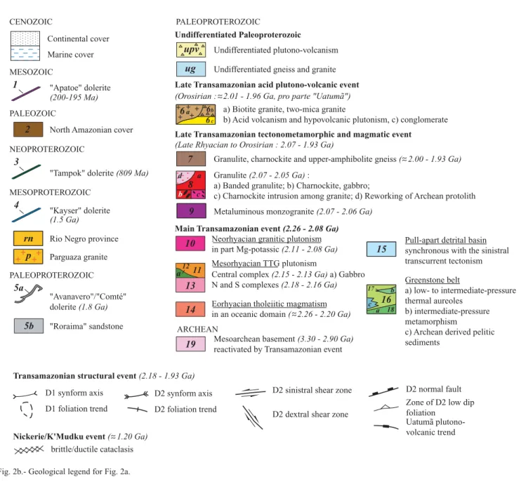
The entire evolution of the so-called Transamazonian orogeny, between ca. 2.25 Ga and 1.95 Ga, took place mainly within the Rhyacian. However, whereas the main tectonothermal activity in the easternmost part of the Shield ended at 2.08 Ga, with only subsequent cooling, the central and western parts of the Shield underwent a further Orosirian tectonothermal event that lasted until about 1.93 Ga. We shall therefore refer to the main Rhyacian evolution (2.26 -2.08 Ga) as the “Main Transamazonian event”, and to the subsequent LateRhyacian to Orosirian evolution (2.07 -1.93 Ga) as a “Late Transamazonian event”.The relationships between the Uatumã magmatism and the Transamazonian events will be discussed at the end of this chapter.
Main Transamazonian event (Rhyacian: 2.26-2.08 Ga)
The northern side of the Guiana Shield includes TTG–greenstone belts and granitic suite domains. Plutonic terms include a wide range of chemical compositions, within which two representative types can be distinguished - 1) a tonalitic-granodioritic-trondhjemitic (TTG) suite, and 2) a granitic sensu lato suite.
This lithological duality, originally inferred by Choubert (1974) as “Guyanais” magmatism and “Caraibe” magmatism, has been refined and geodynamically modeled in the light of plate tectonic processes (Vanderhaeghe et al., 1998; Delor et al., 2003).
Ocean-floor tholeiitic magmatism
The “Île de Cayenne” gabbro and associated trondhjemite, which are exposed along the Atlantic coast, have always been considered as one of the oldest terrains of the Guiana Shield. The initial Archean age proposed by Choubert (1964) for these areas has not been confirmed by later age determinations; for example, Teixeira et al. (1985) obtained early Rb-Sr ages at ca. 1.9 Ga for the Île de Cayenne series, and Milesi et al. (1995) obtained precise Pb-Pb zircon ages at 2216 ± 4 Ma and 2174 ± 7 Ma for the trondhjemite. On the basis of the geochemical characteristics of the rocks, considered to be derived from tholeiitic rocks emplaced at mid-oceanic ridges or within an oceanic back-arc basin, the youngest age has been postulated as representing a stage of oceanization (Vanderhaeghe et al., 1998). A new isotopic study accompanying a recent reappraisal of the geology of French Guiana has provided zircon ages as old as 2208 ± 12 Ma for the Fe-gabbro of “Pointe des Amandiers”, and similar ages from zircons of the migmatized TTG in southern French Guiana (Delor et al., 2001, 2003). These arguments, together with Sm-Nd data on French Guiana sediments and granitoids (Delor et al., 2001, 2003) and on the Ipitinga greenstone in Amapá (McReath and Faraco, 1997) show that the formation age of the early Transamazonian oceanic crust may be as old as 2.26 Ga.
TTG plutonism and greenstone belts
The Paleoproterozoic tonalite/trondhjemite/granodiorite -greenstone belt (TTG-GS belt) can be traced for about 1000 km in the northern part of the Shield, from the Amazon delta in the east to the Orinoco River in the west. It does not, however, form one continuous belt, but consists of two main sections separated by the Bakhuis horst: a western, Venezuela Guyana, belt and an eastern, Brazil -French Guiana - Suriname belt. The geological map of Suriname (Bosma et al., 1978) shows a large greenstone occurrence to the northwest of the Bakhuis horst, which resembles the western belt and the greenstone occurrences to the northeast of the horst. A clear continuation between the
two belts is lacking and, moreover, the eastern belt narrows towards the horst. Nevertheless, available data reveal a large lithological similarity between the two belts, apart from the absence of an Upper Detrital Unit in the western belt.
The eastern belt was formed between 2.18 Ga and 2.13 Ga (Delor et al., 2001, 2003), whereas the western belt contains indications of a similar younger age limit, with felsic volcanics dated at 2.13 Ga (Venezuela; Day et
al., 1995) and 2.12 Ga (Omai, Guyana; Norcross et al.,
2000). The more precise ages determined for the TTG suite of the eastern belt indicate the following evolution:
A first stage of ocean-floor “consumption” with the production of TTG melts dated at ca. 2.18 - 2.16 Ga in the northern and southern parts of French Guiana (Delor et al., 2001, 2003). Along the Atlantic margin, these early TTG products can be traced fairly continuously from the Cayenne area in French Guiana to the Blakawatra area (south of Paramaribo) in eastern Suriname (Fig. 2). In the southern part of French Guiana, they form a 50-km-wide E-W-trending unit that can be traced i) eastward into Amapá with the same strike, and, ii) westward into Suriname with the main trend progressively rotating from E-W to WNW-ESE. Between these northern and southern exposures of 2.18 - 2.16 Ga TTG, we find a significantly younger TTG suite, dated between ca. 2.15 Ga and 2.13 Ga, forming a large batholith in the central part of the French Guiana - this has been termed the Central TTG Complex (Delor et al., 2003).
Greenstone belts associated with the TTG suite include volcanic members (ultramafites, basalts, intermediate to acid volcanics) and sedimentary terms. The regional terminology for these greenstone successions varies from country to country: “Pastora” in Venezuela, “Barama-Mazaruni” in Guyana, “Marowijne” in Suriname, “Paramaca” in French Guiana, and “Vila Nova” in Brazil. In French Guiana, the volcanosedimentary units are caught up in two “synclinoria” lying to the north and south of the Central TTG Complex: a southern greenstone belt (Gruau, 1980; Marot, 1988) and a northern greenstone belt (Ledru et al., 1991; Manier, 1992; Vernhet et al., 1992; Manier et al., 1993; Egal et al., 1994, 1995; Milesi et al., 1995; Vanderhaeghe et al., 1998; Delor
et al., 2001, 2003), which merge westward in Suriname into
a single greenstone belt (Delor et al., 2003) whose trend, south of Paramaribo, veers to the west (Bosma et al., 1983; Gibbs and Barron, 1983, 1993). The western belt in Venezuela and Guyana consists of three greenstone “sub” belts (see Gibbs and Barron, 1993).
The detailed lithological and isotopic studies in French Guiana show that the greenstones consist essentially of submarine lavas and pyroclastic rocks (Ledru et al., 1991; Manier et al., 1993; Egal et al., 1994, 1995; Milesi et al., 1995; Vanderhaeghe et al., 1998) with compositions ranging from basalt to rhyolite, intercalated with scarce sericite-chlorite schist. Pb-Pb ages ranging from 2156 ± 6 Ma to
13 ? 57˚ 59˚ 61˚ 63˚ 65˚ 59˚ 61˚ 63˚ 65˚ 55˚ 5 3˚ 51˚ 57˚ 55˚ 5 3˚ 51˚ 1˚ 3˚ 5˚ 1˚ 3˚ 5˚ 7˚ 10 16 13 6a 6a 6c 10 10 11 1 4 19 13 16 18 13 12 16 10 1 10 12 10 10 1 10 16 3 P aramaribo Macapa Amazon 8d 16 8b 8a 16 14 11 17 13 13 1 8c 8d Cayenne AT LANTIC OC EAN 5a 5b 11 7 7 6b 6b 6b 6a 11 16 2 9 1 Geor geto wn 5b 5b 5b 6b 5b 5a 16 16 11 11 8d 7˚ rn upv ug ug p p p 5a Atlantic Ocean Venezuela Suriname French Guiana Guyana Guiana Shield Colombia Brazil 60º 00’ 50º 00’ 00º 00’ Amapá State 500 km
2137 ± 6 Ma have been obtained on acid to intermediate volcanics (Delor et al., 2003). The positive ε(Nd)tvalues both
of the acid metavolcanic rocks and metagreywacke from the greenstone belts and of associated TTG (Lafrance et al., 1999; Delor et al., 2001; also in Guyana, Venezuela and Amapá, Lafrance et al., 1999; Teixeira et al., 2002b; Nogueira et al., 2000) confirm the juvenile character of the TTG-greenstone complexes and preclude the involvement of significant pre-Transamazonian crust in their genesis. Archean fingerprinting is only displayed by negative ε(Nd)t
values on metapelite and by inherited Archean zircon in quartzite and in some granitoids (Delor et al., 2003).
In Guyana, the volcanic section consists of lower units of tholeiitic basalt and minor komatiite, and middle and upper units of basalt with interstratified andesite, dacite and rhyolite. Tuff, greywacke, shale and less abundant chemical
sediments are interbedded with the volcanics (see Gibbs and Barron, 1993). A similar lithology (excluding komatiite) has been described from Suriname (Bosma et al., 1978, 1984), with a greywacke and shale sequence on top of the metavolcanics. These metasediments were derived predominantly from erosion of the associated volcanics, and show widespread graded bedding indicative of deposition by turbidity currents (Maas, in Bosma et al., 1984).
In a number of respects these greenstone belts resemble arc-type Archean greenstone belts. For example, they exhibit a basic to acid succession. The lower units comprise primitive low-K Fe-rich tholeiitic basalt with a near-horizontal chondrite-normalized REE pattern (10x chondrite), thus differing from oceanic-floor tholeiite (Veenstra, 1978) and showing a strong affinity to island-arc tholeiite (Elliott, 1992; Gibbs and Barron, 1983, 1993; CENOZOIC MESOZOIC PALEOZOIC NEOPROTEROZOIC MESOPROTEROZOIC PALEOPROTEROZOIC PALEOPROTEROZOIC Continental cover Marine cover "Apatoe" dolerite
"Tampok" dolerite (809 Ma)
"Roraima" sandstone "Avanavero"/"Comté" dolerite (1.8 Ga) North Amazonian cover 1
2
Rio Negro province rn Parguaza granite 3 "Kayser" dolerite 4 5b 5a
(Orosirian : 2.01 - 1.96 Ga, pro parte "Uatumã")
Late Transamazonian tectonometamorphic and magmatic event
(Late Rhyacian to Orosirian : 2.07 - 1.93 Ga)
Neorhyacian granitic plutonism in part Mg-potassic (2.11 - 2.08 Ga)
Pull-apart detrital basin synchronous with the sinistral transcurrent tectonism Mesorhyacian TTG plutonism
Central complex (2.15 - 2.13 Ga) a) Gabbro N and S complexes (2.18 - 2.16 Ga) Eorhyacian tholeiitic magmatism in an oceanic domain ( 2.26 - 2.20 Ga) ARCHEAN
Mesoarchean basement (3.30 - 2.90 Ga) reactivated by Transamazonian event
Greenstone belt
a) low- to intermediate-pressure thermal aureoles
b) intermediate-pressure metamorphism
c) Archean derived pelitic sediments 15 16 18 17 a b 19 14 13 10 1211 a 7 upv ug 9 6a 6b 6c
Granulite, charnockite and upper-amphibolite gneiss ( 2.00 - 1.93 Ga) Undifferentiated plutono-volcanism
Undifferentiated gneiss and granite
Granulite (2.07 - 2.05 Ga) :
a) Banded granulite; b) Charnockite, gabbro;
c) Charnockite intrusion among granite; d) Reworking of Archean protolith Metaluminous monzogranite (2.07 - 2.06 Ga)
Main Transamazonian event (2.26 - 2.08 Ga) a) Biotite granite, two-mica granite
b) Acid volcanism and hypovolcanic plutonism, c) conglomerate Late Transamazonian acid plutono-volcanic event
Undifferentiated Paleoproterozoic (200-195 Ma) (1.5 Ga) 8 d a b c D1 synform axis D1 foliation trend D2 synform axis
D2 foliation trend Zone of D2 low dip foliation
Uatumã plutono-volcanic trend D2 sinistral shear zone
D2 dextral shear zone
D2 normal fault Transamazonian structural event (2.18 - 1.93 Ga)
Nickerie/K'Mudku event ( 1.20 Ga) brittle/ductile cataclasis p
c
Fig. 2b.- Geological legend for Fig. 2a.
Voicu et al., 1997). This is overlain by and partly alternates with calc-alkaline andesitic rock with a characteristic island-arc signature (Veenstra, 1978; Elliott, 1992; Gibbs, 1980; Voicu et al., 1997) in the higher units. Associated greywacke and shale, with graded bedding, were deposited by turbidity currents, probably in an arc-trench environment (Bosma et al., 1983). Furthermore, the belts in part show an asymmetric structure (e.g. with respect to the position of the basic volcanics and sediments). These data suggest an island-arc to back-arc marginal basin tectonic setting (Bosma et al., 1983; Voicu et al., 1997). Voicu et al. (2001) suggest successive back-arc closure and extensional oceanic-arc systems caused by migrating spreading ridges.
Detrital series
Unconformably overlying the greenstone belts and TTG suite is an Upper Detrital Unit that crops out in the north of Suriname (Rosebel Formation) and French Guiana (Orapu Formation); it has not been found in the western belt or in Amapá. Composed of sandstone and conglomerate, including monogenic gold-bearing conglomerate, and 5000 m thick, it has been recently referred to as the “North Guiana Trough” (Milesi et al., 1995). Milesi et al. (op. cit.) have inferred the maximum age of deposition to be 2115 ± 4 Ma on the basis of detrital zircon dating. As with the reworked greenstone pelitic terms, the ε(Nd)tvalues of the unit are negative.
In Suriname, the Rosebel sandstone and conglomerate contain pebbles of basic and intermediate volcanics, schist and phyllite, and rare granitic rocks. They exhibit current bedding, scour-and-fill, and other sedimentary structures that indicate deposition in a torrential fluvial environment as alluvial-fan and braided-river deposits (Maas, in Bosma
et al., 1978, 1984). Felsic volcanics are intercalated locally.
The Rosebel deposits show low-grade metamorphism and several stages of folding, including isoclinal folding. However, the presence of enclosed pebbles of phyllite and schist point to an earlier event of deformation and metamorphism (Bosma et al., 1984).
Granitic Plutonism
The youngest magmatic units are represented by a granitic suite consisting of massive intrusives with granular texture. This suite, dated at 2.11-2.08 Ga, is widely developed in southern and western French Guiana (Delor
et al., 2001) where it is associated with a migmatitic facies
containing variably preserved greenstones and TTG from which the migmatites originated. The whole set of transitions from metatexite and diatexite to granite with unequivoquial magmatic textures strongly suggests that granite genesis involved melting of the TTG-greenstone belt. Such evidence of a ca. 2.10 Ga melting process can be seen along the northern Oyapok River on the eastern limb
of the Mesorhyacian central TTG complex (2.15-2.13 Ga), and along the southern and northern Mesorhyacian TTG complexes (2.18-2.16 Ga). At a regional scale, this ca. 2.10 Ga granitic suite is constituting two elongated WNW-ESE trending domains, which merge to the east in Amapá. To the west, only the southern domain is represented and veers progressively from WNW to N-S trends.
Forming part of this ca. 2.10 Ga granitic suite, Mg-K magmatic compositions (amphibole ± pyroxene-bearing granite) and anatexite have been encountered specifically in southern French Guiana and along the Oyapok River. Such hornblende and pyroxene granites apparently extend farther west in central Suriname, in the area of the classical Gran Rio granite described by IJzerman (1931). They are heterogeneous in grain-size and colour and show an inhomogeneous and/or migmatitic aspect, or vague banding and schlieren (Bosma et al., 1978, 1983). Clinopyroxene, usually mantled by hornblende and biotite, is common in the pyroxene granites, and orthopyroxene is present in some of them. The pyroxene granites are associated with high-grade metamorphic enclaves. The granulite-facies rocks of these enclaves are assimilated by the granite (as shown e.g., by xenoliths), which implies that the high-grade metamorphism should be older than the granite (2.11-2.08 Ga), and hence, older than the high-grade metamorphism in the Bakhuis belt. Recent U-Pb and Pb-Pb results on zircons in Amapá suggest that the Transamazonian magmatic episodes in this area are similar to those recognized in French Guiana (Nogueira et al., 2000; Avelar et al., 2001). Nevertheless, late metaluminous monzogranite and pegmatite rock types have been dated at 2.07 - 2.06 Ga and appear to be restricted to the northern part of French Guiana (Vanderhaeghe et al., 1998; Delor et al., 2001, 2003). Late-Transamazonian high-grade
tectonometamorphic and magmatic events (Late-Rhyacian to Orosirian: 2.07-1.93 Ga)
Three northeasterly granulitic domains are known in the Guiana Shield, the well-known Imataca belt (Venezuela) and Bakhuis belt (Suriname), and a co-eval but less-developed remnant of granulites in Amapá and northwest Pará (Brazil). The three domains all belong to the Late Rhyacian granulitic event (2.07-2.05 Ga).
The Central Guyana granulite belt is considered to be limited (see below) to amphibolite- and granulite-facies rocks of northeastern Roraima State in Brazil (Fraga, 1997, 2000), the granulites and high-grade metamorphics from the Kanuku complex in Guyana (Berrangé, 1977), and the Coeroenie high-grade gneisses from southwestern Suriname (Kroonenberg, 1977). This Roraima-Kanuku-Coeroeni belt has an arcuate shape, from NE-SW to NW-SE (Fig. 2). A younger Orosirian charnockitic magmatic event (≈ 1.97-1.93 Ga) has been found in the western extension, in
Roraima State (Fraga et al., 1997; Fraga, 2000), whereas the age of the granulitic metamorphism in this region and the other parts has not yet been dated precisely.
Late Rhyacian granulite domains (2.07-2.05 Ga)
i) The northeasterly trending Imataca belt, in the northwesternmost part of the Guiana Shield, consists of orthopyroxene granulite, subordinate two-pyroxene granulite and minor metasediments (Dougan, 1974). From an isotopic point of view, U-Pb, Rb-Sr and Sm-Nd results on the metamorphic and igneous rocks reveal a complex Archean/Paleoproterozoic history (Montgomery and Hurley 1978; Montgomery, 1979; Teixeira et al., 1999, Tassinari et
al., 2001). Granulitic metamorphism has first been inferred
to have occurred at around 2.10 Ga (Montgomery and Hurley, 1980). More recent analysis by Tassinari et al. (2001) emphasised the Archean nature of granulites in the core of the Imataca complex, with high-grade Transamazonian resetting on its northeasterly margin. However, recent thermochronological study of the São Felix - Upata granulites from the Imataca complex indicates a late Transamazonian age for the granulite-facies metamorphism (Tassinari et al., 2003).
ii) The high-grade metamorphic rocks of the Falawatra Group, in western Suriname, occur in a northeast-trending horst in the Bakhuis Mountains (de Roever, 1973, 1975; Dahlberg, 1973). The horst is bounded to the north and south by mylonitized faults attributed to the 1.2 Ga Nickerie Metamorphic Event (Priem et al., 1971). The central part of the horst consists almost entirely of a 30-40-km-wide, 100-km-long zone of charnockite-suite rocks that show a conspicuous, neat and ubiquitous compositional banding on a centimetre to metre scale, and foliation of both mafic and felsic minerals. They almost invariably contain hypersthene. The conspicuous and fairly regular character of the compositional banding suggests a predominantly metasedimentary (and/or metavolcanic) nature. This is also indicated by intercalations of obvious metasediments, such as pelitic gneiss, sillimanite quartzite, spessartine quartzite (gondite), calc-silicate rocks (calcite-scapolite quartzite), and graphite-bearing (enderbitic) bands. Discordant syn- to postkinematic metadolerite dykes are common. The SW of the horst consists mainly of orthopyroxene granites to tonalites, and gabbroic-ultramafic rocks. An anorthosite body was found in the core of the horst.
The P-T conditions for the peak UHT metamorphism have been estimated as 950 °C and 8.5 - 9.0 kb. The UHT metamorphism shows evidence of a counterclockwise P-T path passing from an early cordierite-sillimanite assemblage via a subsequent sapphirine-quartz assemblage to the peak metamorphic assemblage of orthopyroxene-sillimanite-quartz (de Roever et al., 2003). Late retrograde assemblages have recorded mainly a near isobaric or steeper cooling path.
Single zircon Pb-evaporation and whole-rock Sm-Nd dating on the Bakhuis granulite demonstrate that the high-grade metamorphism in the Bakhuis Mountains occurred at 2070 - 2050 Ma, without significant Archean inheritance. On the basis of these integrated petrological and isotopic studies, de Roever et al. (2003) conclude that the UHT metamorphism and associated counterclockwise P-T path in the Bakhuis belt are better interpreted as the result of Late Transamazonian mantle upwelling. Contemporaneous magmatism probably related to the mantle upwelling is formed by the ubiquitous metadolerite dykes in the granulite belt, whereas anorthosite and gabbroic–ultramafic bodies may represent younger magmatic pulses.
iii) The limits of a granulitic domain in eastern Amapá have, hitherto, been imprecisely determined, due to the difficulty of distinguishing metamorphic granulitic rocks and magmatic charnockite. The extent of the easternmost domain shown on Figure 2 takes into account a) our own observations, b) the occurrence of two-pyroxene-bearing assemblages documented by João and Marinho (1982) and c) the field work by Avelar (2002). This zone is located at the junction of the elongated granitic domains extending from French Guiana, and is characterized by flat-lying to low-westward-dipping foliations. At a regional scale these westward-dipping foliations exhibit an arcuate shape from N030 trends (at 2°30 latitude) to N145 trends (at 1°30 latitude). Charnockite is encountered on both northern and southern sides of this arcuate shape. A charnockitic body in the south has been dated at 2.05 Ga by Pb-evaporation on zircon (Avelar et al., 2001), while in the north, close to Calçoene, zircons from another charnockitic pluton furnished a Pb-Pb age of 2.06 Ga (Lafon et al., 2001). Melt veins associated to ductile normal faulting along the southern N145 trends have also been dated at 2.05 Ga. This set of arguments points to a poorly constrained northeasterly trending zone characterized by the presence of 2.06-2.05 Ga charnockite, and by upward movement relative to surrounding granitic gneiss. However, relationships between the charnockitic magmatism and granulitic rocks in central Amapá are not clear, as yet. The 2.45 Ga Rb-Sr age obtained by João and Marinho (1982) and Pb-Pb zircon minimum ages of 2.58 Ga obtained on two samples of granulite by Avelar et al. (2003) are considered to be related to the magmatic protoliths of the granulite; they do not constrain the age of the metamorphism. Sm-Nd dating on garnet from the granulite gave an age of about 2.03-2.0 Ga (Oliveira et
al., 2002), which suggests a Paleoproterozoic age for the
high-grade metamorphism. However, as in the Imataca belt, the existence of at least two high-grade episodes, one Archean and the other Transamazonian in age, cannot be discarded. Furthermore, there is evidence for a close relationship between charnockite magmatism and ductile normal faulting at 2.05 Ga, pointing to partial contemporaneous exhumation in easternmost Amapá.
Orosirian granulite domains (≈≈ 2.0-1.93 Ga) The “Central Guyana Granulite belt” (Kroonenberg, 1976) stretches from W Suriname across S Guyana (Kanuku horst) into Brazil, State of Roraima. The belt supposedly would also contain the Bakhuis high-grade rocks but aeromagnetic evidence (Hood and Tyl, 1973) and lack of relief E of the Kanuku horst do not support a continuation toward the Bakhuis belt but to the SE, to the Coeroeni area in SW Suriname. It is this continuous arcuate trend that we have represented on Figure 2; in the following paragraphs we discuss i) the western branch in Roraima State, Brazil, ii) the NE-SW Kanuku horst in Guyana, and iii) the eastern, NW-SE-trending, Coeroeni branch in Suriname.
i) Fraga et al. (1997) and Fraga (2002) emphasized the presence of true magmatic charnockite in Roraima State, which yielded Pb-Pb zircon ages between 1966 ± 37 Ma and 1933 ± 2 Ma. The Paleoproterozoic TDM(Nd) model ages obtained for these rocks between 2.19-2.08 Ga (Fraga, 2002) are compatible with the 2.2 Ga TDM model age obtained for a sample of Kanuku granulite (Ben Othman et
al., 1984), but the Pb-Pb zircon ages are significantly
younger than that of the Bakhuis granulite metamorphism and contemporaneous charnockitic magmatism, 2.07-2.05 Ga (de Roever et al., 2003).
ii) In Guyana, the Kanuku granulite and migmatite were distinguished by Berrangé (1977). The granulite includes mainly acid granulite and enderbite, and may have been derived from magmatic rocks (Gibbs and Barron, 1993). The migmatite is mainly paragneiss in which the metamorphic grade ranges from amphibolite facies in the southeast (with muscovite) and east, to granulite facies (including orthopyroxene) in the Kanuku horst to the west (Berrangé, 1977).
iii) In southwestern Suriname, the Coeroeni gneiss comprises mainly quartzofeldspathic gneiss and sillimanite gneiss, with minor amphibolite (Kroonenberg, 1976), metamorphosed in the amphibolite or granulite facies. It commonly shows intense folding as well as extensive migmatization. Rb-Sr dating of the gneiss from drill cores and river samples gave an age of 2001 ± 97 Ma (Priem et al., 1977). The Coeroeni gneiss represents a predominantly supracrustal series with few volcanics, and probably formed in an intracontinental surrounding. This would be in line with the finding of reworked Archean zircons in a sample of Coeroeni gneiss (unpublished data, Delor et al., 2000, 2001).
Orosirian acid plutonovolcanic event, pro parte Uatumã (≈≈ 2.01-1.96 Ga)
A plutono-volcanic acid suite occurs in a wide, long zone across the Guiana Shield (Venezuela, northern part of Roraima state, central Guyana, western Suriname) whereas a smaller zone or branch occurs in southern Roraima State and
south Guyana and meets the other zone near the Amazon north of Manaus, in Brazil. The suite (≈2.01-1.96 Ga) postdates all northernmost Transamazonian formations. In western Suriname extensive areas with acid to intermediate metavolcanics occur (Dalbana Formation), which show low-grade metamorphism and wide, open folding (Verhofstad, 1970; Maas and van der Lingen, 1975). They have partly an ignimbritic origin, show a calc-alkaline chemistry and are closely associated with (intrusive) leucogranites, granophyric granites and fine-grained granites. These hypabyssal granites are considered to be comagmatic with the metavolcanics. Widespread biotite granites with K-feldspar megacrysts postdate the metavolcanics and hypabyssal granites (Bosma
et al., 1978, 1984). In French Guiana and to the east in
Amapá, such volcanics have not been found, although a Late Transamazonian age has been suggested for the Mount Belvédère rhyolites in French Guiana, which needs isotopic confirmation.
To the west, the acid to intermediate volcanics and associated hypabyssal granites, referred in the past as Uatumã, form a huge belt in central Guyana (Berrangé, 1977), the Roraima State of Brasil and Venezuela. The Surumu volcanics and related Pedra Pintada granite in Roraima State were dated by zircon dating at 2.01-1.96 Ga (Schobbenhaus et al., 1994; Almeida et al., 1997; Fraga et
al., 1997), the Cuchivero volcanics in Venezuela at 1.98 Ga
(Brooks et al., 1995). The acid to intermediate volcanics and hypabyssal granites of southern Guyana were described by Berrangé (1977).
The suite commonly shows a basal sequence of mature sandstones and monomict conglomerates, called Murua formation in Guyana, Ston in Suriname and Cinaruco in Venezuela (Berrangé, 1977). The basal sequence is conformably overlain by Uatumã volcanics, and both are folded in large open folds (Gibbs and Barron, 1993; Bosma
et al., 1984). This is a clear distinction from greenstone belt
metasediments which show intense folding.
The age and geodynamical position of the Uatumã Suite has been the subject of a long, ongoing debate. At one side the Uatumã volcanics were considered to represent anorogenic magmatism, with ages as young as the Roraima supergroup, then dated at 1.6-1.7 Ga (e.g., Gibbs and Olszewski, 1982). Two main arguments were given, a) the presence of only mild open folds and absence of intense folding; and b) younger, post-Transamazonian ages. E.g. in Venezuela Rb-Sr WR dating showed an age of 1.70 Ga for the volcanics (Gaudette et al., 1985). Therefore, Gibbs and Barron (1993) describe the Uatumã and Roraima Supergroups together, as the Mesoproterozoic cover of the Guiana Shield, and give an approximate median age of 1.8 Ga for the Uatumã supergroup.
The opposite view, such as expressed by geologists from Suriname was that the Uatumã volcanics represent a late,
posttectonic phase within the Transamazonian orogeny. In Suriname acid metavolcanics, hypabyssal granites and surrounding biotite granites were dated at 1874 ± 40 Ma (Rb-Sr WR; Priem et al., 1971). Field relations and xenoliths showed the widespread biotite granites to be younger than the acid metavolcanics and hypabyssal granites. The age was taken as clear evidence for a Trans-Amazonian, orogenic nature of the metavolcanics and granites.
More precise dating by zircon Pb/Pb and U/Pb in the 90’s and after has changed the age framework considerably. Zircon dating of Roraima supergroup sediments showed ages of 1860 and 1875 Ma (Santos et al., 2002, 2003; compared to previous 1.65 Ga ages by Rb-Sr whole rock dating), setting also a minimum age for the end of the Transamazonian orogeny. Zircon datations of Uatumã volcanics and hypabyssal granites are still low in number, but available ages fall in the 2.01-1.96 Ga range (Schobbenhaus et al., 1994; Almeida et al., 1997; Brooks et al., 1995). Therefore, Schobbenhaus et al. (1994) and Reis et al. (2000) include the dated Uatumã volcanics in the Transamazonian orogeny.
The Uatumã suite continues south of the Amazon, in the Guapore Shield. One of the causes of the long debate is that south of the Amazon more rocks were ranged with the Uatumã Suite, because of their similarity. However, in the Iriri Group of the Uatumã Supergroup in the Tapajos Gold Province two volcanic sequences (each with associated granites) can now be distinguished by zircon dating, one formed at 2.00 -1.97 Ga, the other one at 1.89-1.87 Ga, demonstrating the heterogeneity of the Uatumã Supergroup (Lamarão et al., 2002). The two sequences differ in geochemical characteristics, the older one is attributed to subduction-related arc magmatism, the younger one to an anorogenic, intracontinental event (Lamarão et al., 2002). Also in the nearby Carajas Province the 1.87 Ga magmatism is widespread and ranged with the Uatumã Suite (Teixeira et
al., 2002; showing Nd model ages of ca. 3.0 Ga).
Reis et al. (2000) proposed the name of “Oracaima volcano-plutonism” for the 2.0-1.95 volcanoplutonic rocks in northern Roraima State, Brazil, to avoid the confusion related to the name Uatumã. Younger, ca. 1.89 Ga, zircon ages have been reported for acid volcanics and related granites from S Roraima and near Pitinga (Reis et al., 2000; Costi et al., 2000). Reis et al. (2000) found a considerable geochemical difference between the 2.0-1.95 and 1.89 volcano-plutonic sequences, at considerable variance with an anorogenic signature for the 2.0-1.95 “Uatumã” event.
Many rather small gabbroic-ultramafic intrusions occur in W Suriname (De Goeje Gabbro, Bosma et al., 1978, 1984), central Guyana (Appinite Suite, Berrangé, 1997; Badidku Suite, Gibbs and Barron, 1993) and northern Roraima State. The intrusions have not yet been dated by modern isotopic methods. They are essentially undeformed and intrusive in e.g. the acid (meta-) volcanics, but in turn
intruded by the biotite granite of western Suriname (Bosma
et al., 1984), ranged with the Uatumã plutono-volcanic suite.
Therefore, they may be broadly similar in age with that suite. The large PGM-bearing gabbroic-ultramafic De Goeje body in E Suriname, is definitely older and can be ranged with the greenstone belt; its continuation in French Guiana (Tampok), was dated at approximately 2.15 Ga (Delor et al., 2003).
Late Paleoproterozoic post-orogenic cooling
and subsequent magmatism and basin deposits
Apart from the Roraima area marked by abundant Orosirian magmatic activity, thermal assessment of the Transamazonian event by Rb-Sr and K-Ar methods shows that the Guiana shield basement has cooled down below the 500-600°C isotherm between 2.08 Ga and 1.76 Ga (Montalvão and Tassinari, 1984; Nomade et al., 2002). This was without major regional thermal resetting and therefore without a subsequent orogenic cycle. Nevertheless, tectonic and magmatic events of restricted extent argue for regional reactivation in a continental context.Magmatic activity
i) In Pitinga in the South, 200 km N of Manaus, the Agua Boa and Madeira granites, in part with rapakivi structure, are associated with major Sn deposits. They were dated at 1.83-1.79 Ga and are considered as anorogenic, intracratonic granites (Lenharo, 1998; Costi et al., 2000). Slightly younger granite intrusions occur in Amapá, 1.75 Ga (Vasquez and Lafon, 2001; zircon).
ii) Large dolerite sills and dykes of the Avanavero type, dated with ca. 1.79-1.78 Ga ages by zircon and baddelyite dating, are reported from Venezuela, Brazil (Roraima State), Guyana and Suriname (Norcross et al., 1998; Santos et al., 2001). They are much older than indicated by Rb-Sr whole rock dating (Priem et al., 1968; Snelling and McConnell, 1969). A poorly constrained Ar-Ar age of 1.8 Ga has been also obtained on a N030°-trending dolerite dyke in French Guiana. This indication of a Late Paleoproterozoic dyke generation has been extended to the whole set of NE-SW trending dykes in French Guiana (Delor et al., 2001, 2003).
Roraima Supergroup
The thick sedimentary sequences of the Paleoproterozoic Roraima Supergroup postdate all Paleoproterozoic formations and include a variety of sedimentary lithologies that mainly include sandstones, feldsphatic sandstones, conglomerates and dark shales. The deposition of the Roraima Supergroup was developed in the following major environments: fluvial, deltaic, coastal lagoon, beach and shallow marine environments (Ghosh, 1981). The paleocurrent measurement on sedimentary sequences of the Roraima Group (Keats, 1973 and Ghosh, 1981), suggest a
northeasterly, easterly and southeasterly source of sediments. Santos et al. (2003) conclude that the sequences represent a fill in a foreland basin that was derived mostly of the Transamazonian orogenic belt to the north and northeast. An outlier of Roraima sediments occurs to the E, in central Suriname (Tafelberg), and near Pitinga in the South; in French Guiana and more to the east the sediments are absent. Recent datation of Avanavero dolerite sills and dykes (Santos et al., 2001) intruded in the sediments, and of horizons of pyroclastic volcanics interbedded with the middle and upper Roraima sediments, showed that these sediments are substantially older than previously thought (1860 ± 15 Ma and 1875 ± 5 Ma for two horizons, Santos et al., 2001; Santos
et al., 2003). Detrital zircons with an age of 1.95 Ga and older
were found in the sediments (Santos et al., 2001, 2003). The 1875 Ma age was interpreted as approx. the maximum age of the Roraima Supergroup, the dolerite intrusion age of 1.78 Ga as the minimum age (Santos et al., 2003).
Post Paleoproterozoic Intracontinental evolution
Mesoproterozoic and NeoproterozoicFor more data on the Rio Negro Province in the extreme W of the Shield the reader is referred to the recent papers by Santos et al. (2000) and Tassinari et al. (2000).
Significant anorogenic acid magmatism of Mesoproterozoic age took place in the far west of the Shield, near Pitinga in the south, and locally in areas in between. The Parguaza rapakivi granite pluton in the far west, occupying an area of over 10000 km2, was dated at 1546 ± 20 Ma by U-Pb
on zircons (Gaudette et al., 1987). Also the Surucucus intrusive suite (Roraima State), dated at around 1.55 Ga, consists in part of rapakivi granites and is associated with Sn deposits. Ages at 1.56 Ga have also been obtained by Fraga et
al. (1997) for charnockite from Roraima State. In this state
also an example of a complete AMCG, anorthosite-mangerite-charnockite-(rapakivi)granite suite, has been suggested by Dall’Agnol et al. (1999) and demonstrated by Fraga (2002).
A swarm of NW-SE trending dolerite dykes of alkaline affinity, the Käyser dolerite, is associated with a major fault system and a graben structure in W Suriname (de Roever et
al., 2003, this volume). The dykes were dated by Ar/Ar
dating on biotite at about 1.50 Ga. In the eastern part of the shield, evidence for Mesoproterozoic rocks is scarse.
Neoproterozoic tectonometamorphic evidence is of restricted occurrence in the Guiana Shield
i) Throughout the western half of Suriname and in Guyana, Rb-Sr and K-Ar mica dating of Transamazonian granitoids and K-Ar dating of basic rocks indicated a resetting of the ages by the Nickerie Metamorphic Episode at around 1.2 Ga (Priem et al., 1971). In the eastern half of
Suriname such resetting has not been found. Long mylonitic zones along the Bakhuis horst in W Suriname, both affecting its high-grade rocks and Transamazonian granites and metavolcanics, as well as the horst formation itself, are also attributed to the Nickerie Metamorphic Episode (Priem et al., 1971). Similar NE-SW mylonite zones are seen along the Kanuku horst in southern Guyana due to the K’Mudku event (Snelling and McConnell, 1969), and along the Guri Fault, near the Imataca Complex in Venezuela, due to the Orinoquean Event.
ii) In French Guiana, a sample from NW-SE trending dolerite dykes has been dated at 809 ± 29 Ma by the K-Ar method (Delor et al., 2003). An analysis of the paleomagnetic poles confirms its inconsistency with younger Mesozoic dolerite dykes (Théveniaut and Delor, 2003).
iii) Alkaline complexes of varying age have been found locally. They consist mainly of nepheline syenite and strongly weathered rocks, which in cases were interpreted as carbonatites. An example is the Muri/Mutum intrusion at the border of Brazil and the Guyana-Suriname disputed territory. K-Ar dating gave an age of 1026 ± 28 Ma (Oliveira et al., 1975). Other alkaline complexes such as the Seis Lagos carbonatite may be more recent. Alkaline intrusions of the Mapari Suite in Amapá have been dated at
ca. 1.7, 1.5 and 1.3 Ga (Lima et al., 1974).
iv) Alkali basalts and troctolites of alkaline affinity of the Cachoeira Seca suite occur near the Amazon, N of Manaus. They were dated at 1.19 Ga (Santos et al., 2002; baddelyite).
Phanerozoic continental breakup
Phanerozoic formations (sediments and dykes) when observed, give account of subsequent continental breakup during the Paleozoic (Amazonian basin) and the Mesozoic (Atlantic margin).
i) A widespread magmatic event is represented by the emplacement of Apatoe-type dolerite dykes in Venezuela, Guyana, Suriname, French Guiana and Brazil. Large dyke swarms in eastern Suriname and French Guiana cut all the above-described lithologies. In French Guiana they are oriented NNW-SSE and, more rarely, WNW-ESE. K-Ar whole-rock ages range from the Late Triassic to Early Liassic (Priem et al., 1968) because of the weathering and excess argon, but accurate Ar-Ar data obtained in French Guiana and Suriname point to an Early Jurassic age (Deckart et al., 1997; Nomade et al., 2000, 2001a,b). The major dyke swarm is located in the northeastern part of French Guiana, close to the mouth of the Oyapok river. The Apatoe dykes mark the precursor stages of the Atlantic ocean opening (see for more details de Roever et al., 2003, this volume).
ii) A tensional event resulted in the fault-bounded subsidence of the North Savannas/Takutu graben in central