HAL Id: hal-01529131
https://hal.parisnanterre.fr//hal-01529131
Submitted on 19 Dec 2019HAL is a multi-disciplinary open access
archive for the deposit and dissemination of sci-entific research documents, whether they are pub-lished or not. The documents may come from teaching and research institutions in France or abroad, or from public or private research centers.
L’archive ouverte pluridisciplinaire HAL, est destinée au dépôt et à la diffusion de documents scientifiques de niveau recherche, publiés ou non, émanant des établissements d’enseignement et de recherche français ou étrangers, des laboratoires publics ou privés.
Distributed under a Creative Commons Attribution - NonCommercial - NoDerivatives| 4.0
(Somme)
Claude Masset, Jacques Pelegrin, Hugues Plisson, Arnaud Blin, Farida
Mazhoud, Dominique Jagu, Michel Girard
To cite this version:
Claude Masset, Jacques Pelegrin, Hugues Plisson, Arnaud Blin, Farida Mazhoud, et al.. L’allée couverte du bois d’Archemont à Méréaucourt (Somme). Gallia Préhistoire – Préhistoire de la France dans son contexte européen, CNRS Éditions, 2013, 55, pp.73-179. �10.3406/galip.2013.2500�. �hal-01529131�
73 G alli a P ré hi st oi re , 5 5, 2 01 3, p . 7 3-17 9
L’allée couverte du bois d’Archemont
à Méréaucourt (Somme)
Claude M
asset1, Jacques P
elegrin2, Hugues P
lisson3, Arnaud B
lin4,
Farida M
azhoud5,Dominique J
agu6,
Michel g
irard71. UMR 7041 (CNRS), Archéologie et Sciences de l’Antiquité, Équipe d’Ethnologie préhistorique, Maison de l’Archéologie et de l’Ethnologie (MAE), 21 Allée de l’Université, F-92-023 Nanterre cedex.
2. UMR 7055 (CNRS), Préhistoire et Technologie, Maison de l’Archéologie et de l’Ethnologie (MAE), 21 Allée de l’Université, F-92-023 Nanterre cedex.
3. UMR 5199 (CNRS), De la Préhistoire à l’Actuel : Culture, Environnement et Anthropologie (PACEA-IPGQ), Université Bordeaux 1, Avenue des Facultés, F-33405 Talence, France.
4. UMR 7041 (CNRS), Archéologie et Sciences de l’Antiquité, Équipe d’Ethnologie préhistorique, Maison de l’Archéologie et de l’Ethnologie (MAE), 21 Allée de l’Université, F-92-023 Nanterre cedex.
5. Doctorante, UMR 7269 (CNRS), Laboratoire Méditerranéen de Préhistoire Europe Afrique (LAMPEA), 5 rue du Château de l’Horloge 13094 Aix-en-Provence
6. Docteur en chirurgie dentaire Paris V, DEA de Préhistoire Paris I.
7. UMR7264 (CNRS), Cultures, Environnements, Préhistoire, Antiquité, Moyen-Âge (CEPAM), Équipe « GRENES », 24, avenue des Diables Bleus F-06357 Nice Cedex 4.
Mots-Clés. Néolithique récent, allée couverte, mégalithique,
sépulture.
Résumé. Érigé au fond d’une fosse, ce monument, construit au néolithique récent, servit pendant six ou huit cents ans de sépulcre collectif. Il présente deux couches funéraires séparées par un remplissage anthropogène. Les inhumations, dans l’une et dans l’autre, furent aussi bien primaires que secondaires : soit au moins 34 sujets pour la couche la plus profonde, et 35 pour la plus haute. Au cours de cette longue période intervinrent des remaniements, des prélèvements d’os, même une vidange partielle. Mieux conservées que les os, les dents ont permis de préciser et de compléter les informations fournies par ces derniers. À cette époque, le monument était couvert d’une toiture légère. Ce n’est qu’en fin d’utilisation qu’il reçut de fortes tables mégalithiques, lesquelles manifestent une condamnation du sépulcre. Le monument fut fréquenté encore un certain temps, temps qui se termina par une destruction intentionnelle de ses parties hautes, associée à un recouvrement partiel. Outre un mobilier assez courant, cette allée couverte a fourni plusieurs perles d’ambre, l’une d’elles exceptionnelle, ainsi que dix haches polies en silex, dont neuf trouvées en place. Ces pièces sont ici l’objet d’une étude tant technologique que tracéologique, étude qui a révélé une diversité inattendue, tant dans leur élaboration que dans leur usage ; à cette diversité est liée leur emplacement dans la tombe. L’environnement a évolué au cours de l’histoire de cette allée couverte : d’abord relativement arboré, il a tôt présenté des signes de défrichement, suivis d’une reprise passagère de la forêt correspondant à l’époque de la condamnation du monument ; suivit un nouveau défrichement, correspondant aux époques historiques. De nos jours, la forêt a repris ses droits.
Key Words. recent Neolithic, Gallery Grave, Megalithic,
grave.
AbstRAct. This monument was erected in a trench, during the recent Neolithic, and was used for six or eight hundred years as a collective grave. It presents two funerary layers separated by an anthropogenic infilling. The burials in both layers were primary as well as secondary, with at least 34 individuals for the lower layer and 35 for the upper layer. During the course of this long period, various interventions occurred, including the removal of bones and even a partial emptying of the grave. The teeth are better preserved than the bones and complete the data provided by the latter. During this period, the monument was covered by a light roof. It is only after use that the grave was closed off by the megalithic table-style slabs. The monument was still visited for a while, before the intentional destruction of the upper parts, associated with a partial covering. Besides rather common objects, this gallery grave yielded several amber beads, one of which is exceptional; as well as ten polished flint axes, nine of which were found in primary position. In this paper, these pieces are the subject of a technological and use-wear study, which reveals unexpected diversity, in both fabrication and use. As well as this diversity, their position in the tomb is of particular interest. The environment evolved during the history of this gallery grave: first it was relatively wooded, it then presented early indications of clearing, followed by transient renewed forest development corresponding to the closing off of the monument; this was followed by renewed clearing, corresponding to historical periods. Today, the forest has reclaimed the land.
74 G alli a P ré hi st oi re , 5 5, 2 01 3, p . 7 3-17 9
EXCAVATION DATA
This gallery grave was explored between 1981 and 1991. It is located 32 km from the gallery grave of La Chaussée-Tirancourt, excavated by us between 1968 and 1975 (Leclerc and Masset, 1980, 2006). Both of these monuments are contemporaneous (Cf. Guy and Masset 1991, 1995).
SITE AND SEDIMENTS; THE MONUMENT
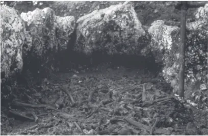
The substratum is not very permeable and is of limited interest for agricultural purposes (sediments trapped in the infilling of the gallery grave provide evidence of the early fertility of the site): (cf Michel Girard below). Not far from there is an “indurated chalk” outcrop, a mediocre material used for the megalithic elements (photo fig. 2; cf. plan fig. 19). We removed the capstones in 1982. We designate the orthostats and the megalithic table-slabs by the name of the square metre where their highest point was located when we arrived on site. Our level zero is 90 cm above the plateau surface.
The gallery grave is slightly trapezoidal in shape and is almost parallel to the contour lines, which is not a common configuration. The orientation of the access corridor is rather unusual (plan fig. 3). The presence of paving is more typical.
An amateur intervention took place in 1930, destroying the entrance zone (Bienaimé, 1933). Other, more discrete operations occured after that.
ARCHITECTURE AND MONUMENT FOUNDATIONS TheimplanTaTionTrench
The gallery grave was erected at the bottom of a trench with rather unclear outlines. It seems to us that this corresponds to an earlier structure which maintained the edge of the trench and was reworked several times.
Changes have been observed in the sediments between the orthostats and the edge of the trench, at an altitude of -160 (altitude of the earliest burials), with in situ frost-shattered flint nodules. Long ago, there was thus a peripheral area outside the monument which remained empty for a long period of time.
Drainage
Like other monuments built in humid environments (Boulanger, 1900; Froelicher, 1906), our gallery grave was erected on sediment prone to waterlogging, with poor drainage. Bone surfaces indicate that the bones were not waterlogged, implying that there was a water-proof cover over the site, like our plastic protections during the exca-vation. As the covering slabs were added at a later stage (see below, “layer II”), I would advance the hypothesis that during the recent Neolithic, waterproof roofs were used to cover buried tombs in the Paris Basin, in Thuringe and elsewhere.
TwoexcepTionalblocks
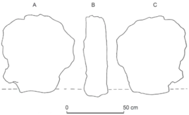
Although all the orthostats are in “indurated chalk”, they display different facies and their summits are located between -80 and -70. The most singular of them is the large block “F13”, which has the dimensions but not the shape of an orthostat (fig. 4). It appears to have been completed by a block of some two hundred kilos, found nearby in layer I. Examination showed that the shape of “E14” adapts to that of “F13” and that, when superposed, they form a solid set, rising to -85 (fig. 5). Perhaps they were used to open (and close) a lateral exit. We know that at La Chaussée-Tirancourt, notably, there were lateral entrances, in addition to the main monument entrance (Leclerc, Masset, 1980).
The triangular block “D16” is smaller than an orthostat and is forcefully wedged between the pillars “E16” and “E17” (fig. 6). It is associated with unusual sediments. It appears to act as a “stopper”. At the base of this block, in E16, there is a zone with no remains amidst dense sets of remains, from the beginning of the gallery grave to the end of the grave function (cf. fig. 3, layer V and fig. 17, layer III-1). We refer to this as “permanent negative evidence of the apse”. It could have provided a passageway towards an exit obstructed by “D16”.
If this was an exit, it is located in the same position in relation to the gallery grave as that observed in the neighbouring structure of La Chaussée-Tirancourt, and also in two Quercy dolmens (Clottes 1969; Carrière, Clottes 1970; Leclerc, Masset, 1983, p. 174). At La Chaussée-Tirancourt, it opens onto a passageway leading into a hand-dug cavity (Leclerc, Masset, 1980).
In Méréaucourt, beyond the apse, there is a well-characterized passage located between the orthostats and the implantation trench wall of the monument (in DEFG/17 and partially G16). At the altitude of the two burial layers, there are two pavings, one above the other. The position of these and the fact that the Neolithic groups made a paving for layer V and then felt the need to pave again in relation to layer III, appears to be very indicative.
aTThemonumenTenTrance
A discoidal stone block with one regularized surface was found in the entrance zone (fig. 7). This is the “stopper” which would have obstructed the monument entrance in the past. In the “Seine-Oise-Marne” complex, at least a dozen of these are known. On one side of this block is sort of tenon which could have been inserted in the mortise observed on the entrance orthostat “H11” (Guy, Masset, 1995). On its counterpart “J11” there is a sort of rebate to which the “stopper” in question may have been attached (fig. 10). If we admit that in the past, the stopper may effectively have obstructed the gallery, then the surrounding orthostats would have subsequently been moved (cf below “An orthostat ballet”; fig. 3).
The small orthostat to the south “H9” had no counterpart. On the other side, between orthostats “J11” and “K11”, is a stone edifice
Archemont Forest Gallery Grave At Méréaucourt (Somme)
75 G alli a P ré hi st oi re , 5 5, 2 01 3, p . 7 3-17 9
which obscures a deep step of 6 to 7cm (fig. 8). A chevron of adequate length could have blocked the previously positioned stopper.
The evolution of the vestibule (fig. 20) shows a superposition of more or less sloped levels, showing that several repairs were carried out during the course of monument use (infra: “Dating” p. 76).
pavinganDDisconTinuiTy
There is paving between -162 and -165, formed of flat nodules (fig. 11 and 13). It is missing in the “negative permanent evidence of the apse” and at the base of the “E15” orthostat, as we will see below. Two discontinuities interrupt the paving, one in the apse zone, the other nearer the centre of the monument: “EF16” and “FG14” (fig. 11): the latter is reminiscent, in particular, of that indicated by Bottet in 1928 at “la Pierre Plate” à Presles (Val-d’Oise), at the same distance (2 m 40) from the apse. “FG14” contained four polished flint axes (fig. 11), as well as an amber bead with a weight of 2 grams (fig. 45). Nearer the apse, “EF16” contained several beads, including an exceptional perforated block of Baltic amber of 8.5 grams (fig. 45 - in Gardin, 1995).
The presence of axes in “FG14” evokes a threshold role for this area (Favret, 1933). Yet, the “detachable orthostat F13/E14” may have been a lateral opening... Other transversal divisions were identified elsewhere, often visible as alignments of small paving stones.
THE BURIALS IN LAYER V (BETWEEN -170 AND -160)
Between approximately -170 and -160, this burial layer takes up a little less than half of the monument, furthest from the entrance (fig. 12): part of our layer V could have been eliminated by Neolithic groups like layer VII of La Chaussée-Tirancourt (cf. Leclerc, Masset, 2006): bipartition of the funerary area? (cf. below, “social segmenta-tion”, p. 74).
The bones are of the same colour and consistency as the sur-rounding sediments. They are accompanied by stones and clayey silt. Although they are generally adjacent, these bones are almost all dislocated.
The skulls tend to be grouped together around the periphery, except in the southwest angle which remains perpetually empty. These skulls either have an upward-facing occiput or profile, but are never positioned face upwards. Epiphyses are rare; diaphyses are sometimes present in bundles and often display dry-bone fractures. Teeth resist better than the other remains and are, at times, the only evidence of disappeared skulls (fig. 18). A lot of these characteristics are present in layer III.
The teeth of several children have been identified. This part of the monument is the only area that yielded beads (fig. 12 and below “Decorative elements” p. 75).
permanenTnegaTiveeviDenceinThesouTh (fig. 12anD14) In EF/14-15, at the base of orthostat “E15”, several elements are missing from the paving. In the same area, several centimetres higher up, the layer of adjoining bones is interrupted: it outlines a sector with no bones, delimited by several large nodules and blocks of chalk (fig. 14). Of rounded shape, our “negative evidence” yielded two axes. It continues up until the summit of layer III. At La Chaussée-Tirancourt, negative evidence of comparable permanence was identi-fied. In layer V at the latter site, this negative evidence is also asso-ciated with a well-characterized interior threshold, and is highlighted, in the same way, by an axe (Leclerc, Masset, 2006).
A permanent element of the history of the monument, our “permanent negative evidence in the south” presents considerable variations (fig. 15). The longevity of this evidence suggests that it was important.
PUTTING INTO PLACE OF LAYER IV iv-2 anD iv-1
Overlying the bones in layer V, layer IV is a thin layer of silt (1 to 7 cm), mixed with stones and small burnt earth nodules. In places, where layer V is missing, several sub-horizontal bones are linked to the sediment characteristic of layer IV; they may be the ultimate remains of layer V removed from this part of the grave.
The base of layer IV is mixed with layer V: we call it IV-2. The bones in this layer are of a good size and there are even strict anato-mical connections: the presence of IV having prevented dislocations. Above this, IV-1 bears small stones mixed with small-sized bones.
TheenDofTheorThosTaT “f15/16”
Two neighbouring orthostats, “F15” and “F16”, are formed of the same material and bear corresponding facing surfaces. They are derived from the same orthostat, “F15-16”, fractured long ago.
“F15” was found by us leaning towards the interior of the funerary chamber and covered by layers II and I. It had fallen onto layer IV, which had just been deposited. The putting into place of layer IV, the breaking up of “F15-16” and the collapse of “F15” are all linked, the latter fell when its wedging was removed. Also associated with the passage from one epoch to the following, comparable observations were made notably at La Chaussée-Tirancourt (op. cit.); at Villedubert (Duday, 1995), at Bryn Celli Ddu (Eogan, 1983). Perhaps here, like at La Chaussée-Tirancourt, this represented a lateral opening, linked to new burials
THE BURIALS IN LAYER III (BETWEEN -160 AND -140)
Layer III is thicker than layer V, but displays a similar facies. It is generally surrounded by an empty zone. The apse sector “ω” (fig. 16), is a little lower down and contains fewer individuals than the rest of the layer.
“III-3”. The lower part of layer III, is the only one to have yielded all skeletal parts. In spite of the absence of anatomical connections, the bones are not distributed in an arbitrary fashion, which evokes the in situ disturbance of dislocated skeletons, rather than secondary burials. There are less children’s remains here than in layer V.
In level III-3, a central sector (β) faces the apse sector (ω). Further to the east is a deep transversal gully, highlighted by pieces of chalk and flint nodules. Beyond that, sector “α” (strongly deteriorated by ancient excavations) evokes a different occupation mode of the tomb from that visible further west.
The anthropogenic infilling “II-2”, presents significant lacunas and may have been deposited progressively. This compact layer is very thin and displays the unexpected appearance of a “base layer”.
“III-1”. Above III-2, there are practically only skulls and long bone diaphyses, mixed with large blocks of chalk, which appear reminiscent of the equivalent sub-layer V-1 at La Chaussée-Tirancourt (Leclerc, Masset, 2006). This “III-1” outlines a rectangle of 2.50 x 0.90 m, surrounded and overlain by skulls.
76 G alli a P ré hi st oi re , 5 5, 2 01 3, p . 7 3-17 9
reflecTionsonfunerarypracTices
We observe a long occupation duration (bones split into “matches”, etc – cf below: “Dating”). Due to the rarity of anatomical connections, our gallery grave differs notably from the neighbouring structures of La Chaussée-Tirancourt (Leclerc, Masset, 2006), Vers-sur-Selle (Bréart, Piningre, 1985) and la Chaise du Diable at Dameraucourt (Delambre, 1908).
Horizontal displacements appear to have been considerable: cf. the distribution plan of schist beads in layer V (fig. 12). In other sites, zones with identifiable skeletons contrast with those where all the bones are dislocated (Leclerc, 1993; Chambon, Mordant, 1995; Chambon 2003): juxtaposition of a primary grave with a bone deposit where defleshing occurred elsewhere. In Méréaucourt, it appears that secondary inhumations coexisted, in position, with deposits of corpses in anatomical connection. In layer III, the minimum number of individuals (“MNI”) is 29 using the left femur and 27 using the teeth; but the latter reveal the presence of 7 children under the age of 11 years old, as opposed to just one child for bones. There are 20 individuals over 12 years old using teeth and 29 using bones. There are twice as many pluriradiculated teeth as monoradiculated (these may have remained elsewhere).
socialsegmenTaTion?
Since the work of Ullrich in Thuringe, we know that there may have been several distinctive sub-populations in the same Neolithic collective grave (Feustel, Ullrich, 1965). This has also been identi-fied elsewhere. It is doubtlessly the case in Méréaucourt, where the apse part, as much “III-3” (ω) as V, contained less individuals than elsewhere: there was a selection.
For layer V, a very marked opposition is manifested between two parts of the monument, on either side of the discontinuity “FG14”: if half of layer V was emptied (like the contemporaneous layer VII, at La Chaussée-Tirancourt) and the other half remained in situ, we would have at least two human groups.
AFTER THE BURIALS: LAYER II
anThropogenicinfilling
Silt, nodules and chalk fill the monument as well as the peri-pheral area.
Large blocks of chalk were placed above the pseudo-orthostat “F13”. These blocks appear to have replaced the large block “E14”, removed at that time.
Layer II manifests marked horizontality, in contrast with the slight plateau slope. This implies that Neolithic populations mastered levelling techniques. The “permanent negative evidence of the apse” is still there, its silty infilling contrasts with the stones in the rest of the layer.
It appears on the profile (fig. 24) that one of the covering slabs “H15”, lies on layer II, which suggests a chronology. Other obser-vations, exposed below, corroborate this point of view (cf. Guy, Masset, 1991).
balleToforThosTaTs
One of the small orthostats of the monumental entrance “H11” had moved, as we saw above (“At the monument entrance”). It had been deported towards the funerary chamber and also pulled up a little. “J12” had also moved, crushing a tibia shaft. No other orthostat is as tilted as “J12”.
“F12” and “G11” are inclined towards the interior of the monument. “G11” is abnormally far from the exterior limit in F/9-10. At its base, the wedging blocks had disappeared: it had moved.
These orthostat movements are centripetal and precede the depo-siting of “layer II”. This moving around appears to be connected to the small dimensions of the megalithic table “G12”: if these orthostats has stayed in their original position, this slab would have fallen between them. As the situation in “H15” suggests, the depositing of layer II would have intervened between our “ballet of orthostats” and the erection of the covering slabs.
After all these operations, what was left of the funerary monument was no more than a twenty centimetre deep trench, with outlines marked by the top of the orthostats. All this was capped by two mega-lithic tables and appears to have been surrounded by a palisade.
evoluTionofThevesTibule; posT-funeraryacTiviTies
In layer II, the access passage was, from this time onwards, in the axis of the gallery grave. We found at -110, a set of small blunted, adjoining chalk blocks, with a rectangular shape about a metre wide (fig. 21): the remains of a thin chalk slab destroyed by frost, surroun-ded by very frost-shattered flint. The thickness of this slab would have been no more than 15 to 20 cm (fig. 19).
This axial space continued to be used. We found an adze, axe handle, dagger and broken end scraper in Pressigny flint, a red deer canine, flint flakes, several shards.
Above layer II
In the apse zone, outcropping at the surface of layer I, is a consi-derable quantity of very eroded chalk: remains of a small, severely frost-shattered slab (fig. 22), which overhung the peripheral area (fig. 3). We are calling it “F17”. It is in much the same position as the blocks of sandstone at La Chaussée-Tirancourt (Leclerc and Masset, 1980, 1983).
Slightly further towards the east, there are small, very rounded blocks of chalk which were also exposed. Layer I presents a 30 cm deep depression here in F15 and E-F/16 (fig. 23). There may have been a solid wooden table here long ago, covered by chalk, which then collapsed? We would refer to it as a “megaxyle” (from the Greek ξύλον: wood).
INTENTIONAL DESTRUCTION. LAYER I
The building evoked above could have persisted for quite some time, as the elements involved are very frost-shattered. Michel Girard’s palynological analysis confirms this duration.
Then there was another anthropogenic infilling, layer I, which is different from layer II in that the stones are not sorted.
We found table “H15” broken into four elements of unequal size. At La Chaussée-Tirancourt, in an equivalent position, the tops of the orthostats were intentionally broken (Leclerc, Masset, 1980). Another anomaly is that the table “G12” overruns its base “F12” to the south, by about fifty centimetres, whereas to the north, thirty to forty cen-timetres are missing in order to reach the symmetrical pillars “H13” and “J12”. It was too thick (a metre) to be broken like the neighbouring “H15”, and was thus moved towards the south and toppled.
77 G alli a P ré hi st oi re , 5 5, 2 01 3, p . 7 3-17 9
Between these degradations and the influx of layer I, a similar link was identified at La Chaussée-Tirancourt, dated to the beginning of the second millennium (Masset, 1995a). There is a growing corpus of literature concerning intentional Neolithic or early Bronze Age destructions (Leclerc, Masset, 1980; Eogan, 1983; Jagu 1993, 1994; Duday, 1995).
Unlike in layer II, where the grave is visible and still visited, in layer I, it is cut off from the world of the living. This double condem-nation has numerous parallels elsewhere (Leclerc 1987, Jagu 1993, 2002, Jagu et alii, 2008).
laTerinTervenTions
An antique excavation in the south
At a short distance from the gallery grave, traces of fire were observed from DE/12 to DE/16, dated by 14C on charcoal. The time spans overlap: -30 to +389 from our era, and +344 and +670. These Late Period interventions were carefully refilled (fig. 23).
Extraction of a missing table?
We have already noted that layer I presents a depression in the apse zone. This depression may have been caused by the collapse of a wooden slab, but may also mark the removal of a stone table.
conclusion
We intervened at Méréaucourt in the aim of completing our earlier excavation at La Chaussée-Tirancourt. These two monuments turned out to be quite dissimilar, and their similarities are thus all the more interesting; for example, both monuments attest long-distance trade communications.
While it is true that the covering slabs were put into place after the burials at Méréaucourt, there probably weren’t any at any stage in La Chaussée-Tirancourt, nor at any analogous sites.
These two gallery graves presented lateral openings, as well as a main way out, in a corner of the apse. The peripheral space remained empty for a long time. Corpses in anatomical connection, as well as previously dislocated bones seem to have been buried in both tombs. The burial layers reveal sectors, including an apse sector which appeared to play a specific role. Note also the presence of “permanent negative evidence”, which appears to be significant, but which plays an unclear role.
During the course of use at each of the two sites, mutilations occurred, indicating the passage from one period to another. Both present this curious phenomenon of «double condemnation» : after a long period of time, orthostats were broken, covering slabs, where present, were toppled over, and the whole was covered by a “layer 1”, sealing it for ever .
C. M.
FINDS AND DATING
OBJECTS
As is the case in many gallery graves, the objects were concentra-ted in the entrance zone. Below, we present a table of the dimensions on the pieces presented here.
axes, aDzeanDreDDeer anTlerhafTs
The Méréaucourt gallery grave yielded no less than 10 axe or adze blades, including the one taken from the entrance zone in 1930. These pieces are studied below, by Jacques Pelegrin and Hugues Plisson. We present the dimensions of these objects below.
One of them comes from layer I and contributes to the dating of this layer. The only identified adze was found in the vestibule, at the angle of the “chalk mat” (fig. 21). Seven axes were found in position in the funerary chamber, all in key zones: near the monument entrance (fig. 3): in the “southern permanent negative evidence” and at the limit of this zone (fig. 12), as well as in the continuity solution “FG14” (fig. 3 and 12).
axehafTs (Tab. i)
Two axes were still inserted in their handles (in the main paving discontinuity and in the southern permanent negative evidence zone), and a third handle was found in the vestibule, without a blade. All the handles are in deer antler with a transverse perforation. None of them appears to have been polished.
oTherflinTTools
Two blades in Grand-Pressigny flint (“dagger”) were found in the vestibule, at the layer I-layer 2 limit. One of them was broken and transformed into an end scraper, located 4 metres east of the monument entrance. The other (fig. 31), was very well made and must have been over twenty centimetres long before being broken. Two other blades in local flint were found in the vestibule and in F16 in layer V. Two bladelets were found in the entrance zone and a third in layer III, in F14.
blaDeTools; pyriTe
A “chisel” and a “spear point” were noted in the 1930 discoveries (Bienaimé, 1933).
Two tranchets were discovered in the vestibule beside the chalk mat. As well as the end scraper in Grand-Pressigny flint, there are four others, also in the vestibule sector. Two débitage flakes could be burin waste. There are also two borers from the 1930 spoil.
Méréaucourt yielded several lighters, in the burial layers and in the vestibule (fig. 36); four are in rare flint. One of them has the shape of a crested blade, associated with small pyrite fragments (below). Others present traces of iron oxides.
Pyrite: fragments of this substance were found in places, at the base of layer V, not associated with lighters.
cores, flakes, hammers
Several blocks of flint were found during the 1930 “excavations”. Some of these are cores (fig. 38 and 39) and others are hammerstones.
Used laminar flakes, including one issued from a large blade. Others are more shapeless (fig. 40), or come from debitage flakes. About sixty flakes underwent fire action.
DébiTage
There are approximately three hundred knapped flakes, most of which were located near the entrance. Débitage was not particularly standardized. A microburin was found in the 1930 back dizt.
78 G alli a P ré hi st oi re , 5 5, 2 01 3, p . 7 3-17 9 DecoraTiveelemenTs
A deer canine was identified in the vestibule. About eighty beads were found in layer V, concentrated in square F16. Most of them are in polished schist, eight in bone, nine in amber (and maybe one in jade) – the largest amber object (fig. 45) was in the IV-V border. The amber beads were mostly located in the two paving discontinuities (particularly in “EF16”); the other beads were concentrated in square F16, possibly associated with children’s bones.
All the schist beads were dispersed, apart from three that remained in contact. Eight bone beads were found in a very small sector in F16 in layer V (fig. 12), four of them are in pairs. They are larger and less regular than their schist counterparts and several of them present traces of polishing.
DATING
A radiocarbon date on one of the lowest lying femurs in layer V yielded a coherent date with the architecture and objects (3,627 to 3,101 years cal. BC, within two sigmas). The grave was used for funerary purposes up until the final Neolithic (2,910 to 2,497 years on a tibia diaphysis, cf. notes 26 and 27, page 118). Our layer V was thus roughly contemporaneous with layer VII of La Chaussée-Tirancourt, and our layer III with layer V of the latter site (Leclerc, Masset, 2006). It was then used for a long time as a memorial (cf. daggers in Grand-Pressigny flint) until the Bronze Age limit. The equivalent layers at la Chaussée-Tirancourt are in the following time ranges: 2450-1770, 2400-1690, 1940-1330 (Leclerc, Masset 2006, p. 94). Like at La Chaussée-Tirancourt and Guiry-en-Vexin (Masset, 1995a and b; Högström et al., 1995), the use duration of our site was close to a millennium.
C. M.
FLINT AXES FROM MEREAUCOURT
The nine polished flint axes from Masset’s excavation of Méréaucourt (a first flint axe was found in 1930 and subsequently lost) have been carefully examined by a flint technologist (J.P.) and a microwear analyst (H.P.).
Most of the pieces underwent a specific and complicated history, as regards both their fabrication and their technical features.
For instance, it appears that different grinding stones could be used for grinding and repairing the same axe head. Among the flint axes, some (fig. 49, 50, 51, 54, 57) display a very straight side-edge portion bearing parallel striations, which demonstrates that they were initially ground in the rectilinear groove of a grinding stone. Such straight grooves develop on a large grinding stone when an axe is placed in a partial split prepared halfway along a branch and is then pushed / pulled back and forth by two people (Madsen 1984, Pelegrin 2012).
Two methods of cutting edge sharpening could be distinguished (although some pieces displayed unskilled or unfinished resharpening attempts): one consisted in a single shiny edge facet obtained in humid conditions (fig. 51), the other appears on each side of the cutting edge with 3 to 6 minute edge facets with a matt aspect, produced in dry conditions, obviously with some kind of device (fig. 52C). Other axes were ultimately resharpened in the same way, for instance fig. 49, 50, but others were clumsily resharpened and even partly damaged
by attempts to refresh their cutting edge directly on a grinding stone (fig. 59C). The shaft of one of these axes seems to have been delibe-rately lustred (fig. 53).
Overall, it appears that resharpening was carried out by indivi-duals with different levels of skill, and also that some pieces were worked by several individuals with varying degrees of experience.
The technical state of the axes is quite variable, ranging from a high quality newly-made piece (fig. 51) to pieces at different reduction / resharpening stages or even heavily damaged axes. Besides the newly-made piece, one is recent but displays partial and mediocre or unfinished resharpening (fig. 52), two were carefully resharpened after a long use cycle (originally much longer: fig. 3 and 4, both found with their antler haft), one used - apparently to dig clay- after early resharpening and some polish- (fig. 53), two were clumsily resharpe-ned after a short (fig. 55) or a long history of use including reshaping of the butt (fig. 57, 59B). The last two axes display damaged cutting edges - apparently intentionally damaged on bone (fig. 54, 56, 58). These correspond to the late sequences of the tool cycle: one was clumsily knapped, ground and sharpened (fig. 56), whereas the other was partly reworked after a use accident (fig. 54).
Curiously, the few use marks observed at this stage are not attri-butable to woodwork. Besides the two axes damaged on bone (which is certainly not “standard” use), one piece bears earlier traces of some humid and silica-rich material (mineral or vegetal: fig. 56). We already mentioned that one displayed clay wear (fig. 53), and another had been used on a relatively tender and abrasive material (fig. 55).
Apart from the two axes with damaged cutting edges, the newly-made piece and the piece displaying both polish and use wear (fig. 53), there are five resharpened axes. This could indicate that it was important to introduce these precious tools into the monument in a renewed state, even if three of them were rather hastily or clumsily resharpened.
It is interesting to note that the two pieces damaged by a violent impact on a rather hard bone-like material were the last pieces deposited in the monument. One of them (fig. 56) was placed in the vestibule after the burial period of the monument with other items, including a Grand-Pressigny flint dagger (which indicates a Late Neolithic event), and the other in layer I, which corresponds to the final filling of the structure.
J. P. & H. P.
ANTHROPOLOGY OF LAYER V
Layer V is the oldest burial layer discovered at Méréaucourt. The absolute date indicates that it was used during the second half of the 4th millennium. It was only exposed in the lower part of the chamber, as Torchon’s excavations did not reach this part of the monument (fig. 60). Layer V is separated from the paving by a fine layer of silt. No stratigraphic division was identified.
The bones are characterized by extensive fracturing. They were regularly eroded by runoff, which complicates bone identification and age determination. The comparison of bone and dental MNI (this volume) led to the identification of at least 34 individuals, 28 adults and 6 immature individuals (fig. 61 and tab. VI). Sexual diagnosis was not possible due to the state of preservation of the coxal bones. The adult osteologic profile is very imbalanced. Both large bones, such as
79 G alli a P ré hi st oi re , 5 5, 2 01 3, p . 7 3-17 9
the cranio-facial block, and small bones, such as the talus, are well represented, suggesting that at least half the adults were deposited in the vault as corpses. For the younger individuals, it is not possible to advance a hypothesis.
Bone distribution is not regular in the dozen square metres which yielded bone remains. Three sectors can be distinguished: the apse, made up of squares EF 15-16, where two-thirds of the bone remains were discovered, squares F 13-14, with close to 25% of the remains and bands G, H and J, which contain sparse bone remains.
The apse corresponds to the main deposit zone, in direct contact with the negative evidence in EF 14-15 and in E16 and near the possible opening between the orthostats E16 and E17. Most of the connections observed in layer V were in the apse. Several second order osteologic liaisons were also noted in this zone. They made it possible to reconstitute the disposition of individual 1, corresponding to an adult buried lying on his/her stomach along the main axis of the tomb, with his/her head oriented towards the apse (fig. 62). His/her upper limbs must have been folded under the thorax. This is one of the last deposits of layer V.
The apse yielded 75 % of the immature bones. In number, immature individuals represent a little more than 15 % of the archaeological population, which does not correspond to the mortality of a prejenerrian population. This result cannot solely be explained by the state of pres-ervation of the human remains. There was a selection of buried indivi-duals to the detriment of immature indiviindivi-duals, a recurrent trait in the gallery in the Paris graves. Furthermore, the distribution of immature individuals is juxtaposed with bead distribution.
As well as being affected by natural disturbances, the bone accu-mulation was also affected by anthropic activities. According to the osteologic profile of layer V, about twenty individuals are represented by several bones whereas at least half of the adults were deposited as corpses. Bones were thus removed. As it happens, human remains are almost absent from the anterior half of the chamber, which cannot be imputed to Torchon’s excavations. The chamber entrance was almost totally emptied and the apse partially emptied by Neolithic populations.
A. B.
ANTHROPOLOGY OF LAYER III
In archaeoanthropology, it is not easy to reconstitute rituals linked to death; it is all the more difficult given the multitude of funerary practices. The study of the osteoarchaeological sample issued from the gallery grave of Méréaucourt is part of a wider problem which consists in defining the buried population as well as possible and shedding light on ancient funerary practices.
METHODS
TheosTeologicalseries. conDiTionofTheseries
This sample is very fragmented. Moreover, the quality of the bone objects is mediocre.
Aim of the study
In anthropology, the over or underrepresentation of
anatomi-cal elements raises questions concerning the existence of specific funerary practices. How can we explain the fact that a bone in good condition can be underrepresented in a series? Does the absence of information stem from taphonomic processes or from deposition modes of the deceased?
The study of the series from Méréaucourt is based on the possible existence of secondary deposits or reductions along with primary deposits. In order to prove or disprove this hypothesis, we tried to weigh up the possible disproportions, significant under or overre-presentations with the level of fragmentation and the qualitative and quantitative state of preservation of the different bone pieces.
counTs
The sample from Méréaucourt was counted using a very detailed frequency MNI and a MNI by exclusion, distinguishing two groups; an adult group and an immature group. A first estimation concer-ning the long bones took into consideration the proximal and distal extremities, thereby rejecting the diaphyseal elements, which are sources of errors for calculating the MNI However, as there are a lot of diaphyseal elements, in order to optimize results, the sums of the MNI obtained from diaphyses, were then integrated into the first inventory.
palaeoDemography Sexual diagnosis
No sexual diagnosis could be carried out from the study of the coxal bones. On the other hand, it was possible to identify the gender on certain cranial fragments (Ferembach, 1979; Buikstra et al., 1989; White, 2000).
Estimation of age at death
Only long bone shafts are generally preserved, which led to the classification of specimens into adult or immature groups according to their dimensions (notably using diaphysis diameter) and the thickness of cortical bone. The estimation of the age of adolescents was conducted using the study of the synostosis of the bone epiphysis and diaphysis (Bass, 1995; White, 2000), in particular for long bones. For the study of immature individuals under 15 years old, we took diaphyseal lengths into consideration and we used the tables of Stloukal and Hanakova, dating from 1978. Along with those, the different stages of dental eruption and calcification were also examined (Ubelaker, 1978; 1989).
The study of the estimation of the age of adults is based on the observation of the different anatomical parts, notably the pelvic girdle (Todd, 1920; Lovejoy et al., 1985a; Suchey et al., 1990).
Estimation of stature
The technique used for the estimation of stature consists in measuring the maximum length of certain long bones in centimetres. The results are obtained according to the tables in Olivier et al. (1978).
QuanTificaTionofconservaTion
The qualitative and quantitative states of preservation were measured for bones issued from three squares located in different sectors of the gallery grave: squares E16, G15 and H13. These three
80 G alli a P ré hi st oi re , 5 5, 2 01 3, p . 7 3-17 9
squares are interesting in that they are sufficiently far apart from each other to propose results which may be characteristic of the whole of the gallery grave. The estimation of both the qualitative and quantita-tive states of preservation may contribute to making a clearer case for the possible presence or absence of taphonomic agents. In this way, the underrepresentation of good-quality bone pieces which are not highly broken, may be explained by the differential selection of these pieces by Neolithic groups, rather than by differential conservation. Bone representation
The method applied here to quantify bone representation was developed by P. Dodson and D. Wexlar in 1979 (cited in Denys et al., 1987). The Bone Representation Index (IRO) applied establishes the ratio between the number of bone elements present and the theoretical number of the same bone elements which should be present in the sample (depending on the MNI).
State of preservation
In order to quantify the extension of the conservation of the whole sample, the R. L. Lyman method (1994) was used. This method consists in transcribing the ratio between whole bones (Ne) and the total number of pieces (NR) contained in the sample.
As for the qualitative conservation, all the pieces from the three reference squares were distributed into five categories representing their state of conservation, based on the ratio between the well-pre-served cortical surface and the altered cortical surface of each bone (Bello, 2000).
RESULTS
minimum numberof inDiviDuals
The first estimations of the MNI do not incorporate the diaphyseal elements and are based on the observation of 633 bones (cf. fig. 63).
The best score comes from the left femurs. This first result is 29. The results of the estimation of the MNI based on the study of the diaphyseal elements do not disrupt the initial results as the best-repre-sented diaphyseal elements are the left femurs, still with 29 elements (cf. fig. 64).
palaeoDemography Sexual diagnosis
A total of eleven bones, all from skulls, provide the necessary elements for a sexual diagnosis. Out of the eleven skulls or cranial elements subjected to a macroscopic examination, ten were masculine and one feminine.
Estimation of age at death
Out of the 3,391 bones that make up the sample, 2,790 were distri-buted into two main categories, as follows (cf. fig. 66):
- 2,687 adult estimations, or 96% of reliable estimations,
- 103 immature estimations, or 4% of reliable estimations.
Several age estimations were conducted in a more accurate manner.
The observation of all the pieces yielded the following results:
- 0-4 years old: 1 piece,
- 15-19 years old: 16 pieces,
- Adolescent to young adult: 4 pieces,
- Young adult: 1 piece,
- Young mature adult: 4 pieces,
- Mature adult: 9 pieces,
- Old mature adult: 9 pieces,
- Old adult: 2 pieces.
Different explanations, based on differential identification or dif-ferential conservation, can be advanced in order to shed light on this differential representation. After eliminating other possibilities, the hypothesis of differential recruitment appears to be the most plausible. Estimation of stature
There are eleven results for the estimation of stature. As it was not possible to carry out sexual diagnoses for the eleven bones, we applied both types of stature, masculine and feminine, to each of the eleven pieces (cf. table VIII).
Male statures range from 149.6 centimetres to 172.8 centimetres. Female statures extend from 150.9 centimetres to 173.4 centimetres. The estimated statures point to small sizes.
sTaTeofconservaTion
The extent of fracturing of our sample is 92.33%, which underscores the very fragmentary nature of the material from the Méréaucourt series.
Bone Representation Index
The long bones (humerus, ulnas, femurs, tibias, fibulas) present good to very good overall representation (cf. table IX). On the other hand, other pieces, such as scapulas, hyoid bones, sternums, carpal and tarsal bones, display poor to mediocre conservation .
Quantitative and qualitative conservation Quantitative conservation
For square E16, the extent of fragmentation is 95.9%.
Conservation is poor to mediocre for the larger bones, such as those from lower and upper limbs. On the other hand, the smallest bones are the best represented. For example, conservation is good to excellent for bones from the hands (cf. table X).
For square G15, the extent of fragmentation is 96.9%.
Once again, the largest bones are the most fragmented (cf. table XI) and the smallest elements are the least fragmented.
For square H13, the extent of fragmentation is 93.4%.
Once again, the results are similar (cf. table XII). We can take for example, the lower limbs, for which 25 out of 27 elements present poor to mediocre conservation. On the other hand, all the bones from the hand display good to excellent conservation.
Qualitative conservation
The study of the qualitative conservation of bones from square E16 reveals mediocre to poor conservation for the whole sample and, more specifically, for the scapular girdle, the upper and lower limbs. We also note that the hand bones are the only elements in good condition (cf. table XIII).
81 G alli a P ré hi st oi re , 5 5, 2 01 3, p . 7 3-17 9
conservation. Few pieces display good conservation (four), made up of a cranial element, a rib, an upper limb element and bone from the hand (cf. table XIV).
Square H13 is no exception to the rule and also reveals a poor overall qualitative state of preservation. Once again, long bones present the most altered cortical surfaces and bones from the hand are the best preserved (cf. table XV).
DISCUSSION sTaTeofconservaTion Bone representation index
Certain bones are well represented. This is the case for long bones, which are among the best represented pieces, but also for patellas, cranial elements, atlas and axis vertebrae.
On the other hand, we note the mediocre representation of other pieces such as mandibles, scapulas and coxal bones.
Bones from hands and feet are compact, and therefore robust. However, our sample displays a clear underrepresentation of these bones.
This underrepresentation cannot be explained in taphonomic terms. Consequently, we advance the hypothesis that the low representation of bones from hands and feet could reflect specific funerary practices. Quantitative and qualitative conservation
The results of the study of the state of quantitative and qualitative conservation seem to be homogenous in the three squares (E16, G15 and H13).
Quantitative as well as qualitative conservation is poor for the largest bones, such as the long bones, which can be explained by the fact that they are subjected to faster deterioration, due to their larger volume (Marshall et al., 1991). The composition of certain bones can also render them more fragile than others. This is the case for coxal bones, sacrums, ribs and vertebrae, as their spongy bone structure renders them less resistant.
For all of these pieces from the Méréaucourt sample, the results concerning representation and conservation do not appear to differ from usual results.
On the other hand, hand and foot bones present higher quantita-tive and qualitaquantita-tive conservation scores. However, although they seem to be very resistant, they are not well represented. Different explana-tions can be advanced.
In order to attempt to answer our questions, the results of the study of layer III at Méréaucourt were compared with those from burial 13 at Balloy, Les Réaudins (Seine-et-Marne).
siTecomparison
Burial 13 from Balloy, Les Réaudins (Seine-et-Marne)
The necropolis Cerny de Balloy was excavated from 1987 to 1994, under the direction of D. Mordant.
The necropolis is made up of about fifty tombs, spread out over a surface of ten hectares, at the base of the slope of the Seine valley, in a chalky soil (Chambon et al., 1996a).
To the north of the necropolis are three collective burials: burials 13, 26 and 54.
It is the first of these structures that we chose to compare to the
Méréaucourt sample.
Grave 13 at Balloy is located to the east of monument III, in a funerary enclosure dating to the Middle Neolithic I (4700-4500 before J.-C). As far as funerary practices are concerned, two burial areas seem to be clearly distinct. The first is located to the west and yielded the dislocated remains of 27 individuals, whereas the second, further to the east, contained nine more or less complete skeletons with numerous connections.
These two sectors were not physically separated but were supe-rimposed in the centre of the grave; the dislocated bones were placed below the bones in anatomical connection (Chambon et al., 1996a; Chambon, 2003).
The age of the grave was obtained by radiocarbon measurements on bones from the west. The structure dates to the end of the Neolithic or the beginning of the Bronze Age; 2460-2140 before J.-C. (3850-56 B.P.).
The interest of this comparison resides in the fact that grave 13 at Balloy presents two different profiles:
- an area with primary burials,
- a zone of secondary burials.
Comparison of the representation profiles
After comparison, it clearly appears that the bone representation profile from the gallery grave of Méréaucourt is similar to that of the ossuary zone in the Balloy grave (cf. fig. 69).
These results point us towards the following hypothesis: the Méréaucourt galley grave could have been a funerary monument with multiple post-mortem human interventions.
mulTiplefunerarypracTices
Given the multiplicity of funerary practices, we have retained the hypothesis of the parallel existence of primary burials and secondary deposits (cf. fig. 68). Corpses would have been deposited inside the gallery grave. Then, anatomical connections would have disappea-red due to numerous post-mortem interventions and manipulations. Skeletons would also have been brought into the gallery grave, repre-senting secondary burials. The different representations imply that most of the bones were brought into the grave without flesh, or were at least partially defleshed.
In the present state of our knowledge, this appears to be the only plausible explanation.
CONCLUSIONS
The bone representation profile of our sample revealed funda-mental results, namely, the clear underrepresentation of the smallest bones, from the hands and the feet.
The very good state of conservation of these elements implies that secondary burials probably took place in the gallery grave. However, we cannot rule out the possibility that other funerary practices occurred at Méréaucourt.
Questions still subsist at the end of this study. Thus, for reasons of geographic proximity, a comparison with the osteological series from the gallery grave of La Chaussée-Tirancourt, located at about thirty kilometres from that of Méréaucourt, could be envisaged. This study could perhaps indicate whether funerary practices at Méréaucourt are part of a more general pattern and if they represent a local specificity. F. M.
82 G alli a P ré hi st oi re , 5 5, 2 01 3, p . 7 3-17 9
ODONTOLOGICAL STUDY
Our study consisted in more than mere inventory of dental remains, as we wished to sought how these remains reacted in a col-lective grave. It is important to recall that these remains are small, therefore elusive, and may thus have escaped voluntary or involuntary Neolithic sorting by those responsible for maintaining these tombs. In brief, this could be an empty grave, the emptied contents of a grave, or possibility both.
At Méréaucourt, the anthropological bone and dental anthropolo-gical remains are in very poor condition, which tends to favour tooth counts as the calcified compostion of the latter is more resistant than bone remains. We take into account permanent teeth, temporary teeth, their alveoli and teeth lost ante mortem.
We counted a total of 1,067 teeth, most of which were isolated. The first MNI, which is a global count including all the levels, amounts to 62 individuals, consisting of 54 individuals over the age of 12 and 8 younger ones.
Detailed counts, by archaeological layer and eruption age show that 33 individuals are from layer III and 29 from layer V.
It is important to note the presence of temporary tooth buds, which is extremely rare (four children in layer III and one in layer V). This detail does not appear in the bone remains count.
The study of pathologies is limited, given the poor state of conser-vation of these remains. We observe very pronounced abrasion, which is common during the Neolithic, and only five MOD-type (mesio-occluso-distal) caries.
D.J.
PALYNOLOGY
As the successive accumulations of corpses and sediments generated significant deposits, pollen analyses were carried out in the stratigraphy and provided evidence of the evolution of the landscape during several centuries of monument use.
The diagram (fig. 70) for layers III to I, brought to light three periods of vegetation.
The first (-150 to - 135 cm) is characterized by a relatively high rate of tree pollen (ca. 50%). Dominated by the lime tree (Tilia = 24.6 %), the tree stratum is made up of diverse essences: hazel (Corylus = 15%), oak (Quercus), pine (Pinus), alder (Alnus), ash, (Fraxinus), elm (Ulmus), yew (Taxus), birch (Betula), willow (Salix), juniper (Juniperus), maple (Acer) and ivy (Hedera).
Herbaceous species are represented by grasses (Poaceae), Compositae (Asteraceae), Cyperaceae and ferns (Filicales). Pollen from cereals (Cerealia), plants commensal with crops and taxa linked to the habitat (ruderal group) are present. The environment corres-ponding to this period is partially forested and includes cereal crops. The second episode (-130 to -115 cm) is marked by a major regres-sion of tree pollen (ca. 20%). The oak (Quercus) is strongly affected and the lime tree (Tilia) disappears at the end of this phase.
The herbaceous stratum is dominated by grasses (Poaceae). Cereals present a continuous curve and country meadow plants develop: Caryophyllaceae, Centaurea, Papaver. Fallow land is indicated by the presence of Brassicaceae (Cruciferae), Renonculaceae, Polygonum t.
aviculare, Knautia (Behre, 1981).
During the last episode (-110 to -98/80 cm), oak (Quercus), hazel
(Corylus), elm (Ulmus) and alder (Alnus) increase. The beech (Fagus) and the hornbeam (Carpinus) appear. The most recent level displays an increase in the pine (Pinus) and the presence of the vine (Vitis) and the walnut tree (Juglans). The decrease in cereals and associated plants appears to correspond to a transitory agricultural decline. The ensuing opening of the environment reflects the installation of agri-cultural populations during historical epochs.
Some of the isolated samples (table XXV) are linked to layers II and I. The others contain too few pollen for interpretation.
The chronology of the site is based on the 14 C date from level III (4170 +/- 80 BP) and on the pollen series. These data place the occu-pation during the Sub-Boreal (4500 - 2500 BP), and more accurately, during the Van Zeist and Van der Spoel-Walvius (1980) zones 8 and 9. The lime tree, which plays an important role, is well represented in the peatlands of the region; it appears to begin to develop at the end of the Atlantic (Leroyer, 2003).
The yew (Taxus), observed in level III, also confirms this chro-nological attribution. It is present during this period at Chivres, Silly-la-Poterie and Fréchencourt (Van Zeist, Van der Spoel-Walvius, 1980) as well as at la Pointe-aux-Oies (Munaut, Gilot, 1977, 1980). This essence is also present during the first half of the Sub-Boreal (Leroyer, 2003).
Pollen analyses of archaeological sites in the Parisian Basin clearly show the existence of clearing and the presence of cereals during the final Neolithic, like at Vers-sur-Selle (Munaut, 1985), Videlles (Roux, 1967) or Germigny-l’Evêque (Roblin-Jouve, Girard, 1979), for example.
The appearance of the beech (Fagus) in the upper level is also a fundamental chronological marker as this species makes an appea-rance in the region towards 3000/2500 BP (Huntley, Birks, 1983). In Larchant cave, for example, the beech appears during the final Bronze Age, around 2800 BP (Girard, 1993).
The limit between layers II and I thus occurs during the Sub-Atlantic (zones 10 and 11 of Van Zeist and Van der Spoel-Walvius, 1980), cha-racterized by the regression of the lime tree and the development of the beech and the hornbeam. In the peatlands, the beech appears first, whereas the hornbeam only appears in the landscape several centuries later (towards1500/1000 BP). This phenomenon is particularly visible in the synthetic diagram of C. Leroyer (2003). At Méréaucourt, the simul-taneous presence of these two taxa indicates a sedimentary interruption between the top of layer II and the base of I (-110 cm).
The Méréaucourt diagram thus shows an evolution of the landscape during the course of the long-term use of the necropolis. The gaps correspond to inputs of materials, in particular between upper layer II and the II-I limit and between the latter and its top.
Although the original plant environment in which prehistoric populations installed their necropolis is not known with certitude, we can assume that it occurred at the final Atlantic / beginning of the Sub-Boreal boundary. The spectra from layer III (Sub-Boreal) indicate that the environment was relatively wooded during the last stages of the funerary use of the gallery grave but that signs of clearing were already visible. The pollen series from the sealing off phase of the monument show temporary forest renewal, which indicates that the place was abandoned. The ensuing recorded clearing probably corresponds to historical periods (Sub-Atlantic).
M. G.
83 G alli a P ré hi st oi re , 5 5, 2 01 3, p . 7 3-17 9
INTRODUCTION : POURQUOI
MÉRÉAUCOURT ?
C’est sur une proposition de M. Roger Agache, alors directeur des Antiquités Préhistoriques de Picardie, qu’a été entreprise la fouille de ce monument funéraire. Nous cherchions une allée sépulcrale qui fût proche de celle de La Chaussée-Tirancourt (fig. 1), fouillée par notre équipe entre 1968 et 1975. Nous espérions pouvoir distinguer ce qui, dans cette dernière, avait valeur générale, de ce qui n’aurait été qu’anecdotique (Leclerc, Masset, 1980 et 2006). Ces deux monuments se trouvent, à vol d’oiseau, distants de 32 km. Ils sont contemporains, à l’imprécision du radiocarbone près : leurs couches les plus anciennes tombent dans la même four-chette chronologique, grosso modo à la fin du IVe millénaire
(cf. infra, p. 120, note 27).
Ces deux monuments mégalithiques sont, en réalité, assez différents. Leurs ressemblances n’en sont que plus instruc-tives. Certaines d’entre elles paraissent même généralisables à une bonne partie du domaine dit « Seine-Oise-Marne », et peut-être plus loin. Cela nous amènera à évoquer plus d’une fois La Chaussée-Tirancourt.
Nous avons fouillé l’allée sépulcrale de Méréaucourt entre 1981 et 1991, à raison de dix campagnes d’un mois. Sa publication s’est faite attendre, car une étude anthropologique a
longtemps fait défaut 1. Quelques particularités du monument
ont cependant déjà fait l’objet de publications car elles pouvaient intéresser d’autres fouilleurs de sépultures néoli-thiques, notamment en ce qui concerne la pose – tardive – des dalles de couverture (cf. infra, p. 104 ; Guy, Masset, 1991) et par l’existence d’un dispositif de fermeture original de l’entrée monumentale (cf. infra, p. 90 ; Guy, Masset, 1995).
SITE ET SÉDIMENTS
Aux confins des départements de la Somme et de l’Oise (fig. 1), l’allée couverte de Méréaucourt est située sur le petit plateau du Bois d’Archemont, à 180 m d’altitude, entre la vallée des Évoissons et celle du ru d’Éramecourt 2. Le sous-sol
est composé d’une craie coniacienne, recouverte d’une argile
1. Au cours de cette longue attente, ont été égarés une partie des documents de chantiers, notamment les plans correspondant aux campagnes 1983 à 1989. Ont heureusement subsisté les cahiers de fouilles et la plus grande partie de la photothèque, laquelle compor-tait notamment une couverture stéréoscopique verticale de toutes les zones fouillées. Cette couverture a permis de suppléer partiellement aux plans disparus. Quelques crânes manquent à l’appel. On en compte en effet 35 sur les photographies d’arrivée sur la couche III, alors que l’anthropologue chargée d’étudier cette même couche n’en a eu entre les mains que 28.
2. Coordonnées Lambert zone 1 : x = 571,28 ; y = 1224,95. Coordonnées géographiques : 49° 43’ 25’’ Nord et 1° 56’ 22’’ Est. Fig. 1 – Plan de situation.
84 G alli a P ré hi st oi re , 5 5, 2 01 3, p . 7 3-17 9
à silex supportant elle-même un limon ancien dont l’intérêt agricole est médiocre : le terroir est abandonné à la forêt. Il n’en était pas de même autrefois, vu que, piégé dans les sédiments de remplissage de l’allée couverte, subsistait un reste de limon récent, identifié par la sédimentologue (information inutile pour le lecteur) Brigitte Van -Vliet-Lanoë (Van Vliet-Lanoë, Masset, 1974). Actuellement disparu des environs du site, ce limon, cousin des terres à blé picardes, couvrait donc jadis tout ou une partie de ce qui est aujourd’hui le Bois d’Arche-mont, et le rendait apte à la culture. On verra plus loin, dans la contribution de Michel Girard (cf. infra, p. 170) qu’il se trouvait effectivement des céréales au voisinage de notre monument. La présence de cultures aurait pu favoriser l’érosion du limon, trop peu épais sans doute pour avoir longtemps résisté.
LE MONUMENT
Lors de notre arrivée, l’allée couverte présentait deux tables mégalithiques 3, toutes deux basculées (fig. 2 4, 19 ). La
princi-pale pesait huit tonnes ; l’autre était cassée en quatre morceaux inégaux. Il n’y avait pas de couverture mégalithique au chevet du monument. Ces fortes dalles avaient cruellement souffert avant notre arrivée (cf. infra, p. 104, et p. 107). En 1982, nous avons donc estimé légitime de les déposer, afin de permettre la fouille des couches sous-jacentes. Nous les désignons par le nom, entre guillemets, du mètre carré où se trouvait, à notre arrivée, leur point le plus élevé. Nous faisons de même pour les orthostates.
3. La nomenclature utilisée se compose ainsi : les noms des carrés de fouilles (H/15, EFG/7-9), les noms des tables ou dalles de recouvre-ment (« H15 »), les orthostates (H15).
4. Longue de 2 m 80, la table la plus proche (« G12 ») avait déjà été trouvée basculée par Albert Torchon. On distingue derrière cette table l’extrémité nord de la table fracturée « H15 », basculée dans l’autre sens. Au-delà de cette dernière, une surface discontinue de blocs de craie interne à la couche I. Au premier plan, deux orthostates du vestibule : « G11 » et « H11 » ; plus loin « J12 »
De forme tant soit peu trapézoïdale, l’allée couverte mesure en largeur 2,30 m au chevet et 3,60 m au niveau du vestibule, pour une longueur de 8,50 m (fig. 3) ; elle est presque parallèle aux courbes de niveau, disposition qui est loin d’être fréquente 5. Quelque peu insolite est l’orientation du couloir
d’accès : encadré par un orthostate sur un seul côté, il ne paraît pas dans l’axe du monument (cf. infra, p. 90). Plus banale est la présence d’un dallage couvrant en grande partie le fond de la chambre sépulcrale. Notre niveau zéro est à 90 cm au-dessus de la surface du plateau (c’était, à l’origine l’altitude du sommet de la principale table mégalithique).
ANCIENNES FOUILLES
Une intervention inexperte eut lieu en 1930, exécutée par le propriétaire d’alors, M. Albert Torchon : c’est à lui que l’on doit la destruction de la zone de l’entrée. Ce genre de fouil-leurs publiait peu ; il reste pourtant de son activité quelques lignes dans un bulletin régional, sous la plume d’un érudit local qui s’était trouvé passer par là (Bienaimé, 1933). D’autres informations nous sont parvenues en 1989 par le truchement d’un ancien maire d’Éramecourt, du nom de Pierre Leclerc, qui avait dans son jeune âge manié la pioche pour Torchon ; il nous raconta, entre autres, pourquoi son employeur avait interrompu sa fouille : radiesthésiste, il recherchait surtout des objets en métal ; l’apparition des os l’avait décontenancé, d’autant plus que sa femme lui avait alors déclaré « ces pauvres gens : tu ne peux pas les laisser tranquilles ? ». C’est donc à la respectable Mme Torchon que nous devons d’avoir sauvé le site. Notre fouille a reconnu les traces d’autres interventions, plus discrètes quoique largement traumatisantes, le long de la paroi nord du monument (fig. 19). Nous soupçonnons qu’elles aient été postérieures à celles d’Albert Torchon. En effet, des gens du pays se rappelaient, étant enfants, avoir rampé sous la plus petite des deux dalles de couverture. Or, selon M. Leclerc, la chose n’était pas possible à l’époque où il avait « fouillé ». Il avait donc fallu qu’un jour quelqu’un y eût creusé, (causant pro-bablement un dommage irréparable, p. 88 à 90). Ajoutons qu’un auteur picard plus récent, résumant le texte de 1933, l’enrichit d’une « urne pleine d’ossements, retournée l’orifice en bas », inconnue de Bienaimé (Leduque, 1972).
APERÇU DE LA STRATIGRAPHIE :
LES COUCHES
Bien que notre fouille ait commencé naturellement par la couche I, nous pensons rendre plus intelligible ce monument complexe, en respectant la succession qu’avaient connue les Néolithiques.
5. La plupart des monuments de ce type s’enfoncent perpendiculai-rement aux courbes de niveau, (sauf évidemment ceux qui sont en terrain plat). Font exception, outre l’allée couverte de Méréaucourt, celles de La Bellée à Boury-en-Vexin et de Champignolles à Flavacourt, l’une et l’autre dans l’Oise, donc peu éloignées de la nôtre (Auguste, 1980) ; on peut en rapprocher celle de la La Vente-des-Forts à Mauny, en Seine-Maritime, bien qu’elle ne suive pas exactement les courbes de niveau (Verron, 1979).
Fig. 2 – L’allée couverte de Méréaucourt à la veille de l’enlèvement
des dalles de couverture. Vu prise au dessus du couloir d’accès.
Méréaucourt gallery grave just before the removal of the covering slabs. Photograph taken above the access corridor.
85 G alli a P ré hi st oi re , 5 5, 2 01 3, p . 7 3-17 9 173 172 177 110 83 84 163 213 185 130 170 198 208 181 hache (env. 170) "Fouille" 1930 Zone détruite Vestibule Zone détruite Bouchon C D E F G 16 15 14 13 12 11 10 9 8 Couloir 90 G H J K L 10 11 12 13 14 15 16 17 H15 H13 J12 J11 K11 H11 H9 G11 F12 F13 E14 E15 E16 D16 ? 94 83 79 115 74 54 78 73 73 74 90 125 77 160 a b c d e Témoin négatif permanent Sud 191 Témoin négatif permanent du chevet E17 73 F16 100 F15 N N N N
Orthostates au niveau de la couche V
Autres blocs de craie
Pavage de rognons jointifs (massif de gros rognons souvent plantés sur champs
Emplacement supposé du bloc E14 à l'époque V Limites de fouille
Solution de continuité du dallage Alignement de gros rognons jointifs au voisinage de l'entrée
Petites zones sans rognons
Autres limites de sédimets dans la même région Emplacements actuels des orthostates F15/16, G11 et H11 a b c d e
Argile jaune-rouge avec rares rognons
Argile rouge avec quelques rognons
Rognons jointifs dans un limon brun friable
Rognons jointifs dans une argile jaune-rouge
Rognons jointifs dans une argile en poches jaunes et rouges Limite (parfois approximative) de sédiments
Fig. 3 – Plan de l’allée couverte au niveau de la couche V.