HAL Id: hal-02933320
https://hal.archives-ouvertes.fr/hal-02933320
Submitted on 30 Oct 2020
HAL is a multi-disciplinary open access
archive for the deposit and dissemination of
sci-entific research documents, whether they are
pub-lished or not. The documents may come from
teaching and research institutions in France or
abroad, or from public or private research centers.
L’archive ouverte pluridisciplinaire HAL, est
destinée au dépôt et à la diffusion de documents
scientifiques de niveau recherche, publiés ou non,
émanant des établissements d’enseignement et de
recherche français ou étrangers, des laboratoires
publics ou privés.
landslides
Robert Emberson, Niels Hovius, Albert Galy, Odin Marc
To cite this version:
Robert Emberson, Niels Hovius, Albert Galy, Odin Marc. Oxidation of sulfides and rapid weathering
in recent landslides. Earth Surface Dynamics, European Geosciences Union, 2016, 4 (3), pp.727-742.
�10.5194/esurf-4-727-2016�. �hal-02933320�
www.earth-surf-dynam.net/4/727/2016/ doi:10.5194/esurf-4-727-2016
© Author(s) 2016. CC Attribution 3.0 License.
Oxidation of sulfides and rapid weathering
in recent landslides
Robert Emberson1,2, Niels Hovius1,2, Albert Galy3, and Odin Marc1,2
1GFZ Deutsches Geoforschungszentrum, 14473 Potsdam, Germany
2Institute of Earth and Environmental Science, University of Potsdam, 14476 Potsdam, Germany 3CRPG-CNRS-UL, 54500 Nancy, France
Correspondence to:Robert Emberson ([email protected])
Received: 31 May 2016 – Published in Earth Surf. Dynam. Discuss.: 6 June 2016 Revised: 3 August 2016 – Accepted: 5 September 2016 – Published: 22 September 2016
Abstract. Linking together the processes of rapid physical erosion and the resultant chemical dissolution of rock is a crucial step in building an overall deterministic understanding of weathering in mountain belts. Landslides, which are the most volumetrically important geomorphic process at these high rates of erosion, can generate extremely high rates of very localised weathering. To elucidate how this process works we have taken advan-tage of uniquely intense landsliding, resulting from Typhoon Morakot, in the T’aimali River and surrounds in southern Taiwan. Combining detailed analysis of landslide seepage chemistry with estimates of catchment-by-catchment landslide volumes, we demonstrate that in this setting the primary role of landslides is to introduce fresh, highly labile mineral phases into the surface weathering environment. There, rapid weathering is driven by the oxidation of pyrite and the resultant sulfuric-acid-driven dissolution of primarily carbonate rock. The total dissolved load correlates well with dissolved sulfate – the chief product of this style of weathering – in both landslides and streams draining the area (R2=0.841 and 0.929 respectively; p < 0.001 in both cases), with solute chemistry in seepage from landslides and catchments affected by significant landsliding governed by the same weathering reactions. The predominance of coupled carbonate–sulfuric-acid-driven weathering is the key difference between these sites and previously studied landslides in New Zealand (Emberson et al., 2016), but in both settings increasing volumes of landslides drive greater overall solute concentrations in streams.
Bedrock landslides, by excavating deep below saprolite–rock interfaces, create conditions for weathering in which all mineral phases in a lithology are initially unweathered within landslide deposits. As a result, the most labile phases dominate the weathering immediately after mobilisation and during a transient period of depletion. This mode of dissolution can strongly alter the overall output of solutes from catchments and their contribution to global chemical cycles if landslide-derived material is retained in catchments for extended periods after mass wasting.
1 Introduction
Bedrock landslides can produce favourable conditions for weathering by funnelling runoff into deposits of broken rock mass with massive free mineral surface area and modest hy-draulic conductivity. It has been shown in the western South-ern Alps (WSA) of New Zealand (Emberson et al., 2016) that this can give rise to strong gradients in dissolved solid concentrations in surface waters on hillslopes, with highest concentrations in seepage from landslides, and that the rate
of landsliding is an important control on the chemistry of the rivers draining the mountain belt. Localised landslide weath-ering, prone to the spatial and temporal variability of mass wasting, contrasts with common models in which weather-ing is controlled by steady and distributed erosion of a lat-erally continuous soil and regolith mantle (Dixon and von Blanckenburg, 2012; Hilley et al., 2010; Ferrier and Kirch-ner, 2008; West, 2012; Lebedeva et al., 2010; D. D. Li et al., 2014). Such models anticipate that at high erosion rates
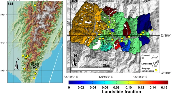
Figure 1.Locations of sampling. (a) Location of T’aimali catchment and landslides sampled outside of this river in Taiwan. (b) T’aimali River, with individual streams outlined over a relief map derived from ASTER DEM (Advanced Spaceborne Thermal Emission and Reflec-tion Spectrometer digital elevaReflec-tion model). Streams are colour-coded by the fracReflec-tion of their area occupied by landslides (scars and deposits); individual landslides are also highlighted as they were mapped from satellite imagery, together with the alluvial fill in the channel. Locations where we sampled landslide seepage are also shown.
weathering is kinetically limited, so that the link between ma-terial supply and weathering is progressively weakened and finally lost. Landsliding circumvents this by exhuming rel-atively unweathered bedrock from deeper below the surface (Gabet, 2007) and, crucially, fragmenting the mobilised ma-terials so that weathering is locally optimised. Landsliding is the dominant erosion process in orogenic settings where rapid crustal shortening is paired with fast and persistent humation (Dadson et al., 2004; Hovius et al., 1997). We ex-pect, therefore, that it may act as a first-order control on dis-solved solids export from active mountain belts. Here, we ask does highly localised landslide weathering persist in different settings with variable lithology and climate such that a more general case for the impact of landslides on weathering can be made, and if so, then what is the underlying mechanism by which weathering is boosted?
To address these questions, we have investigated chemical weathering in the rapidly eroding mountains of Taiwan on the landslide and catchment scale. Our study site has a substrate of typical continental margin sediments, comprising calcare-ous sandstones and shales and containing sulfide minerals (Das et al., 2012). This is a marked contrast with the WSA, where the meta-sedimentary silicate rocks contain only lim-ited amounts of carbonate and very little pyrite (Chamberlain et al., 2005; Koons and Craw, 1991). In this study, we exploit
the synchronous occurrence of voluminous mass wasting in southern Taiwan due to exceptional rainfall associated with Typhoon Morakot in 2009 to eliminate the effects of pro-gressive loss of soluble minerals, allowing a sharp focus on the causes of elevated weathering rates in recent landslides. Using samples of seepage from recent bedrock landslide de-posits and water from mountain streams and rivers paired with catchment-wide estimates of landslide volume, we show that enhanced weathering in landslide deposits results pri-marily from the rapid reaction of the most labile minerals in the substrate, which are excavated from below the saprolite– bedrock interface by deep-seated slope failure. In the case of our Taiwanese site, the oxidative weathering of highly reac-tive pyrite and the ensuing rapid sulfuric-acid-driven weath-ering of carbonate dominate the output from recent landslides and are a first-order control on the stream chemistry.
2 Field sites and sampling
The mountains of Taiwan have erosion rates that are amongst the highest on Earth (between 4 and 6 mm yr−1(Willett et al., 2003; Fuller et al., 2003), driven by rapid tectonic conver-gence at the East Asian margin and aided by tropical storm activity and earthquakes (Dadson et al., 2003). Average an-nual mass wasting rates are high (Hovius et al., 2000) but can
be pushed to much higher rates by single, exceptional storms or seismic activity (Hovius et al., 2011; Lin et al., 2008; Marc et al., 2015). For example, in 2009 Typhoon Morakot caused over 2.7 m of rain in 48 h (Chien and Kuo, 2011) on the southern part of the island, the highest storm totals ever recorded in Taiwan. The typhoon generated more than 22 000 landslides (Lin et al., 2011; West et al., 2011), with an average density of 35 000 m2km−2, orders of magnitude more than under less exceptional meteorological conditions. This presents a rare opportunity to study an extensive pop-ulation of recent, synchronous landslides, which is impor-tant because the rapid weathering in landslides might decay over a decadal timescale to levels indistinguishable from that on surrounding hillslopes (Emberson et al., 2016). Having a constant, known date of initiation for sampled landslides re-duces any systematic changes to weathering that would be introduced by variable timing of the mass wasting. More-over, having a total landslide surface area and volume dom-inated strongly by input from one single typhoon makes the solute load of rivers draining catchments with otherwise di-verse landslide histories directly comparable.
We sampled water from a variety of sources within the T’aimali River catchment (Fig. 1b) between February and March 2015. This catchment drains an area of 118 km2 in the east flank of the Taiwan Central Range, from the main divide to the Pacific Ocean. It had among the highest catch-ment landslide densities resulting from Typhoon Morakot, and several subcatchments sustained catastrophic alluviation. As a result, human settlement and activity in the catchment were abandoned inward of 7 km from the coast, and at the time of sampling, anthropogenic influence was negligible. In addition to the T’aimali main stream, we sampled stream water from 19 subcatchments, with areas between 1 and 10 km2, and geothermal spring water. We also sampled seep-age from the deposits of 13 landslides. This water has cir-culated through the landslides and derives from rainfall and in some cases is likely supplemented by runoff into crests of landslides. We supplemented our landslide seepage samples from the T’aimali catchment with seepage from eight recent landslides elsewhere in southern Taiwan (Fig. 1a) to assess landslide weathering over a wider range of locations.
Lithologically, the T’aimali catchment is representative of the Tertiary sedimentary cover that forms a large proportion of the Taiwanese orogen (Central Geological Survey, 2000); the slates, shales,t and sandstones of the Miocene Lushan and Eocene Pilushan formations contain important amounts of sedimentary and diagenetic carbonate and are pyrite-bearing throughout (Das et al., 2012). The sampled landslides out-side the T’aimali catchment are also rooted in the Pilushan formation, with the exception of two landslides in the Cheny-oulan catchment in central west Taiwan, underlain by the Eo– Oligocene Paileng formation of slates and sandstones. Else-where in Taiwan the sedimentary carbonate content of the sampled formations is between 0.28–0.66 % (Hilton et al., 2014), and the sulfide abundance in the south of Taiwan has
been estimated at 0.05–0.27 % (Kao et al., 2004). The litholo-gies of these formations are the dominant sedimentary rocks formed at continental margins with a clastic input, and they are found globally in active mountain belts (Hartmann and Moosdorf, 2012).
Sampled landslides vary in size between 7.6 × 10³−2.8 × 10⁶m2, and their deposits cover a range of shapes. The largest landslides in the T’aimali catchment initially blocked the main river channel and have since been incised, leaving massive fan terraces, tens of metres above the current river level. Intermediate landslides have built debris cones on hillslopes and at the edges of valley floors, and some smaller landslides have filled debris chutes. All sampled landslides had mobilised bedrock in addition to the overlying regolith and soil mass and any present vegetation. Soils are generally only > 1 m in local concavities in the landscape (Lee and Ho, 2009), but contiguous, dense vegetation on hillslopes that have not been dissected by landsliding suggests that sufficient mobile regolith or soil is present to support flora. In the T’aimali catchment and at other landslide sample sites, the modal topographic slope is around 26◦, with many steeper hillslope segments.
Seepage was found at the base of many landslide deposits, immediately above the interface with underlying bedrock. The flow paths of this seepage could enable fluid interac-tion with exposed rock in the landslide scar as well as frag-mented rock mass in the deposit. We do not draw a dis-tinction between these, as the physical process of bedrock landsliding remains responsible for the exposure of the scar and the production of the deposit. Moreover, it is not possi-ble to distinguish systematically between landslide scar and deposit from available satellite imagery. Landslide seepage may also incorporate deeper groundwater, which could exfil-trate through the scar. We compare sampled seepage with our own measurements of geothermal water as well as with the composition of deep groundwater reported in the literature to qualitatively assess the importance of deeper-sourced water in landslide outflow.
Notably, when we sampled during the early part of 2015, the south of Taiwan underwent one of the driest periods on record, with an estimated return time of 50–100 years (CWB (Central Weather Bureau), 2016). At this time, the sampled streams were at or close to a baseflow condition, but despite the dry conditions more than half of around 50 deep-seated landslides we visited had persistent seepage. It seems prob-able that many landslides in southern Taiwan are never fully “dry” in the current climate. Landslides in the Chenyoulan catchment were sampled in July and November of 2013, when more normal rainfall conditions prevailed.
Further, it is important to note that the sediment generated by landslides and debris flows does not reside exclusively on the hillslopes from where it was sourced. Significant storage of material over long time spans in larger river channels is common and is indeed substantial along the T’aimali River, with alluvial channel fill occupying about 6 % of the total
catchment area. This channel fill may be an important weath-ering reservoir, and to investigate whether this stored sedi-ment affects the observed river chemistry, we have mapped the fill deposits along sampled streams.
Since we sampled small seepages and first-order tribu-taries, we lack good constraints on the fluxes of solutes. Dis-charge gauging is not available in the T’aimali, as the hy-drometric infrastructure on the river was destroyed by chan-nel bed aggradation after Typhoon Morakot. Here, we re-port measured solute concentrations in landslide seepage and stream waters with unknown flow rates. These measurements cannot be converted into solute fluxes without major assump-tions, and weathering flux estimation is not the purpose of this study. Instead, we aim for a direct comparison of land-slide seepage and river chemistry from a set of lithologically similar streams with identically timed mass wasting but vary-ing populations of landslides.
3 Methods
In this section, we report the analytical techniques used to obtain the data in Sect. 4 summarise these results. In later discussion, we compare measurements of both chemical con-centrations and ratios with physical data about landslides and catchments derived from remote sensing. In general, we fo-cus on qualitative links between these parameters, using sta-tistical tests (R2coefficient of determination and p value to test significance of relationships) to support suggestions that parameters are connected.
3.1 Analytical techniques
Samples were collected from the source using an HDPE (high-density polyethylene) syringe, filtered on site through single-use 0.2 µm PES (polyethersulphone) filters into sev-eral HDPE bottles, thoroughly rinsed with filtered sample water. Samples for cation analysis were acidified using ul-trapure HNO−3. pH and temperature values were measured in the field at the time of sample collection.
Analysis of cations was carried out with a Varian 720 inductively coupled plasma optical emission spectrometer (ICP-OES), using SLRS-5 (Saint-Laurent River Surface, Na-tional Research Council - Conseil NaNa-tional de Recherches Canada) and USGS M212 as external standards and GFZ-RW1 (GFZ-River Water) as an internal standard and quality control (QC). QC samples were included for every 10 sam-ples to account for drift; no systematic drift was found, with random variability less than 5 %. Sample uncertainties were determined from calibration uncertainties and were always lower than 10 % (see Table 1 for element-specific uncertain-ties). Anion analysis was performed using a Dionex ICS-1100 Ion Chromatograph, using USGS standards M206 and M212 as external standard and QC. Uncertainties were al-ways less than 10 % for each of the major anions (Cl−, SO2−
4 ,
and limited NO−3). Bicarbonate (HCO−3) was calculated by
charge balance, which has been shown to introduce errors of approximately 10 % (Galy and France-Lanord, 1999). We make the simplifying assumption that the dissolved inorganic carbon (DIC) is formed only of HCO−3, which is generally applicable in the range of pH values measured (Zeebe and Wolf-Gladrow, 2001). The calcite saturation index of mea-sured waters was determined using the USGS PHREEQC software package (Pankhurst and Appelo, 2013).
3.2 Cyclic input
Solute input from atmospheric sources can be significant in rivers and streams and is routinely corrected for in many weathering studies. Previous work on the average chemistry of rainfall in different parts of Taiwan has found that it is highly dependent on location (e.g. higher pollutant content near the densely populated west coast (Wai et al., 2008)) and the intensity of rainfall (typhoon rainfall boasts the high-est solute concentrations in some cases; Cheng and You, 2010). Using any of these measurements to correct our sam-ples based on the assumption that all present chloride de-rives from cyclic input (following, e.g., Calmels et al., 2011) resulted in clearly erroneous estimates of the proportion of cyclic salts in the water samples (e.g. > 100 % of dissolved K+ and SO2−4 from cyclic sources). Notably, chloride is a minor component in all samples, with a median value of 32 µmol L−1(minimum 14.6, maximum 175 µmol L−1). This is a similar range of values to rainwater measured in other coastal environments (Galloway et al., 1982; Nichol et al., 1997), and the overall correction of total dissolved solids (TDSs) is at most 10 % even with the most concentrated rain-fall we have found in published literature (spot samples mea-sured by Calmels et al. (2011) in the Taroko Gorge). We note that deep groundwater may also introduce chloride, which could lead to overestimates of cyclic input. Moreover, during the dry sampling conditions, excess evaporation could lead to larger proportions of cyclic solutes. In view of the mi-nor amounts of chloride in our samples and because of the caveats mentioned above, we elect not to correct our samples for cyclic input.
3.3 Mapping of landslides
We mapped 576 landslides extant in the T’aimali and sur-rounds prior to Typhoon Morakot and those generated during and after the event until 2015 from LandSat imagery (LS7 & LS8, resolution 30 and 15 m respectively). Landslides gen-erated during Typhoon Morakot were also mapped from a mosaic of Formosat images taken within 1 month of the ty-phoon with a resolution of 2 m. Landslides were identified manually, based on their geometry, topographic position, and surface properties, as described in recent studies (Marc and Hovius, 2015), and digitised on screen in an Arc-GIS envi-ronment; scars and deposits were mapped together as a clear distinction was not always possible from the available
im-T ab le 1. Locations and major element chemistry for all samples. Name Latitude Longitude pH T , ◦C Ca 2 +, K +, Li +, M g 2 +, Na +, Si, Sr 2 +, Cl −, SO 2 − 4 , HCO −,3 TDS, Landslide Landslide Calcite µmol L − 1 µmol L − 1 µmol L − 1 µmol L − 1 µmol L − 1 µmol L − 1 µmol L − 1 µmol L − 1 µmol L − 1 µmol L − 1 µmol L − 1 area, m 2 v olume, saturation ( ± 3 %) ( ± 5 %) ( ± 2 %) ( ± 4 %) ( ± 6 %) ( ± 3 %) ( ± 2 %) ( ± 10 %) ( ± 10 %) ( ± 10 %) ( ± 10 %) m 3 inde x T’aimali & surrounds seepage TWS15-17 22.52297 120.90475 7.63 22.2 2716 73 1.92 1016 571 365 17 128 1453 5109 11 450 83 825 173 825 0.3 TWS15-26 22.59528 120.94849 8.23 21.0 2862 43 bdl ∗ 1117 590 201 18 127 2322 3851 11 131 33 676 51 591 0.7 TWS15-31 22.58965 120.92747 8.06 21.6 1534 25 bdl 857 469 232 13 129 789 3595 7643 7589 7089 0.4 TWS15-33 22.58543 120.92238 8.45 21.3 1324 42 bdl 925 523 289 14 142 798 3353 7410 40 666 66 325 0.8 TWS15-38 22.57942 120.89299 8.68 21.1 1019 48 5.82 3679 559 195 3 101 1965 5979 13 555 14 156 16 264 0.9 TWS15-41 22.57541 120.87698 7.67 21.7 3374 43 bdl 185 334 367 22 42 1198 5100 10 665 35 180 54 682 0.4 TWS15-42 22.56998 120.87584 8.36 19.5 2123 21 bdl 373 317 226 18 53 1366 2582 7080 16 968 20 704 0.7 TWS15-46 22.57503 120.82355 7.30 21.4 4462 168 bdl 179 365 282 13 18 2851 4185 12 523 2 775 932 63 566 055 − 0.2 TWS15-47 22.58521 120.8213 8.26 21.5 3946 41 bdl 240 415 289 14 28 2714 3400 11 088 95 319 206 275 0.7 TWS15-49 22.57556 120.8312 8.29 21.0 2588 46 bdl 41 271 257 11 38 1503 2552 7306 123 628 291 661 0.6 TWS15-51 22.57318 120.85339 8.26 24.5 2975 60 bdl 545 381 267 22 40 2450 2583 9322 19 656 25 183 0.6 TWS15-63 22.51877 120.68069 7.49 22.4 1475 34 3.42 1267 796 162 6 27 661 4965 9397 50 139 87 662 0.1 TWS15-65 22.53412 120.69309 8.39 27.8 1666 77 7.52 3476 452 173 5 21 1867 7069 14 813 214 670 608 272 1.0 TWS15-68 22.76694 120.66478 7.99 23.7 4337 29 4.38 1643 406 199 9 26 4080 4226 14 960 15 609 18 525 1.1 TWS15-72 22.73699 120.71692 7.83 20.8 1680 27 4.80 1081 807 154 8 17 1336 3674 8788 132 000 318 261 0.3 TWS15-73 22.73627 120.71718 7.64 19.5 1926 33 6.19 1412 963 131 9 16 1891 3879 10 267 61 035 11 3912 0.1 TWS15-86 22.44895 120.88542 8.46 20.5 1373 26 3.45 1187 541 244 6 175 749 4026 8332 30 188 44 598 1.0 TWS15-87 22.58739 120.8484 8.43 22.4 3308 39 bdl 229 312 205 19 34 2344 2739 9229 17 940 22 298 1.2 TWS15-90 22.60323 120.84421 7.76 29.8 4658 112 bdl 153 305 230 16 28 3118 3810 12 431 23 787 32 469 0.9 Chen youlan seepage CH1307-101 23.61785 120.89787 7.98 32.4 8344 85 9.94 1189 983 287 36 30 7827 1189 23 292 121 000 284 460 1.3 CH1310-40 23.62402 120.89918 7.46 23.4 3813 42 5.71 1448 638 274 26 27 3649 1448 13 857 13 528 15 310 0.4 T’aimali streams TWS15-23 22.59175 120.93216 8.42 20.5 1164 21 bdl 478 381 225 7 75 454 2699 5505 0.8 TWS15-25 22.59484 120.94132 8.40 20.2 1556 25 bdl 670 515 272 11 101 969 2976 7094 0.9 TWS15-32 22.58802 120.92323 8.34 20.1 1801 0 bdl 876 513 269 13 128 1296 3173 8069 0.9 TWS15-34 22.58496 120.92101 8.42 19.7 892 19 bdl 237 377 287 6 100 235 2077 4229 0.6 TWS15-35 22.58763 120.91415 8.51 20.6 1535 27 bdl 773 326 190 11 55 1014 2901 6830 1.0 TWS15-36 22.58109 120.91301 8.56 19.8 1357 20 bdl 562 381 201 8 99 533 3082 6243 1.0 TWS15-39 22.57508 120.88979 8.47 20.5 1309 17 bdl 614 318 206 5 59 660 2799 5988 0.9 TWS15-40 22.57427 120.88347 8.40 19.9 2627 76 bdl 974 322 186 30 35 2622 2383 9256 0.9 TWS15-43 22.56971 120.87585 8.47 18.3 1326 30 bdl 350 330 219 9 61 617 2435 5377 0.8 TWS15-44 22.57248 120.82725 8.53 18.5 1732 18 bdl 64 247 239 6 30 846 2145 5327 0.9 TWS15-48 22.58458 120.81979 7.77 20.0 2703 30 bdl 106 169 154 7 15 1487 2850 7521 0.5 TWS15-50 22.56602 120.84565 8.46 22.1 2069 34 bdl 137 301 268 8 40 1778 1167 5802 0.7 TWS15-52 22.57761 120.85395 8.19 27.1 2736 78 bdl 138 305 225 13 26 2280 1574 7374 0.7 TWS15-53 22.57609 120.86786 8.46 25.5 1678 61 bdl 1281 296 161 14 37 2138 1990 7657 0.8 TWS15-88 22.58842 120.84806 8.25 22.5 4642 78 bdl 346 480 296 21 42 3734 3068 12 709 1.1 TWS15-89 22.59241 120.84619 8.46 22.0 1902 40 bdl 146 348 275 9 35 948 2571 6275 1.0 TWS15-93 22.62438 120.8435 8.27 25.1 4815 129 bdl 172 273 217 22 20 3761 2880 12 287 1.2 TWS15-94 22.59696 120.84148 8.41 24.3 2962 49 bdl 134 336 226 12 26 1933 2711 8388 1.1 Hot spring TWS15-22 22.59343 120.93897 8.43 24.1 71 862 1611 28 46541 3643 8 40 124 235 7011 100 150 − 0.2 ∗bdl – belo w detection limit.
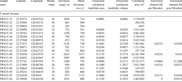
Table 2.T’aimali stream characteristics.
Sample Latitude Longitude Modal Elevation Mean Fractional Fractional Catchment Fractional Fractional name slope range, m elevation, catchment catchment area, m2 channel fill channel fill m a.s.l. landslide area landslide volume pre Morakot post Morakot T’aimali streams TWS15-23 22.59175 120.93216 26 1030 734 0.0002 0.0001 3 129 659 TWS15-25 22.59484 120.94132 30 661 508 496 256 TWS15-32 22.58802 120.92323 32 285 364 8467 TWS15-34 22.58496 120.92101 22 732 547 0.0089 0.0203 1 023 265 TWS15-35 22.58763 120.91415 24 1196 790 0.0010 0.0014 9 861 469 TWS15-36 22.58109 120.91301 28 799 643 0.0030 0.0077 3 359 874 TWS15-39 22.57508 120.88979 23 872 723 0.0350 0.0414 3 652 240 TWS15-40 22.57427 120.88347 28 1126 740 0.1665 0.7246 5 461 061 0.0325 0.0328 TWS15-43 22.56971 120.87585 33 781 711 0.0180 0.0857 1 211 594 TWS15-44 22.57248 120.82725 40 745 868 0.0740 0.1187 357 320 TWS15-48 22.58458 120.81979 33 2653 1473 0.1170 0.2774 62 281 990 0.0218 0.032 TWS15-50 22.56602 120.84565 23 1007 898 0.0690 0.1005 4 423 928 TWS15-52 22.57761 120.85395 31 1308 795 0.0880 0.2111 25 323 473 0.0466 0.1268 TWS15-53 22.57609 120.86786 26 959 805 0.1480 1.2017 3 012 380 0.0214 0.0332 TWS15-88 22.58842 120.84806 31 225 631 0.1293 0.1646 145 453 TWS15-89 22.59241 120.84619 29 484 666 0.0170 0.0637 596 003 TWS15-93 22.62438 120.8435 33 977 1115 0.1660 0.3246 5 670 550 0.0113 0.0348 TWS15-94 22.59696 120.84148 26 1032 806 0.1150 0.1833 4 462 662 0 0.0512
agery. Manual mapping prevents the inclusion of other active landscape elements with recent reflectivity changes, for ex-ample aggraded riverbeds, which were mapped separately. It also suppresses the possibility of amalgamation of multiple landslides into single mapped polygons, which blights auto-matic mapping (Marc and Hovius, 2015; G. Li et al., 2014). In our analysis we draw a distinction between older land-slides and those generated by Typhoon Morakot, prompted by our previous work (Emberson et al., 2016) that has shown that the chemical output from individual slides is likely to significantly decay over a decadal timescale. It should be noted that the proportion of landslides predating Typhoon Morakot is dwarfed by the mass wasting caused by this ex-ceptional typhoon in much of the T’aimali catchment. The proportion of the T’aimali catchment occupied by landslides increased from 2 to 8 % due to Typhoon Morakot, while some subcatchments have upwards of 16 % of their area occupied by typhoon-induced landslides. However, in a few subcatch-ments there is a larger proportion of older landslides, which allows for comparison with landscape units with only negli-gible prior mass wasting.
From the mapped landslide areas, we also estimate the volumes of individual slides, using global area–volume re-lationships (Larsen et al., 2010). We lack direct measure-ments of the depth to which the landslides we sampled have scoured. Errors in the mapped landslide area are assumed to be < 20 %, which are propagated to the total volume esti-mated, as well as the catchment-wide volume estimates. This follows the approach described in Emberson et al. (2016), which allows direct comparison of the estimated landslide volumes in Taiwan and the WSA (Fig. 4).
In addition, we have quantified the area, modal slope, and the mean and range in elevation of each catchment in an
ArcGIS environment, analysing ASTER GDEM (Advanced Spaceborne Thermal Emission and Reflection Spectrometer digital elevation model) V2 data provided by NASA. These data are reported in Table 2.
4 Results: landslide seepage and stream chemistry
Concentrations of total dissolved solids and major cations and anions in landslide seepage and stream water in the T’aimali catchment and elsewhere in Taiwan are listed in Ta-ble 1.
TDS in seepage from sampled landslides in Taiwan ranges between 7080 and 23 300 µmol L−1, while river TDS val-ues lie between 4230 and 12 700 µmol L−1. Thus, the mea-sured TDS in seepage from sampled landslides is consis-tently higher than in other surface water sources, with the ex-ception of geothermal springs (up to ca. 121 000 µmol L−1)
Dissolved calcium is the major cation in most samples, forming up to 90 % (molar) of the cation load in some cases. In some seepage samples this is replaced by magnesium, with Mg2+as much as 70 % of total cations. Sodium makes up much of the remainder of the cationic load, although it only exceeds 15 % molar in three seepage samples. Dissolved silicon (as silicic acid in these pH conditions) never forms more than 10 % of TDS. All measured samples are super-saturated with respect to calcite (Table 1). The anion load is always more than 50 % bicarbonate; the remainder is formed of sulfate, SO2−4 , which is always more than 10 % and can be as much as 50 %. There is significant overlap between landslides sampled within the T’aimali River and those in the immediate surrounds (Fig. 1a); TWS15-68 is the most notable, with relatively elevated SO2−4 and TDS (4078 and 14 932 µmol L−1 respectively). Seepage from the two
sam-pled landslides in the Chenyoulan catchment share the same overall relationships between individual elements as those sampled in the T’aimali catchment, although the measured concentrations are higher than in the majority of T’aimali seepage samples.
The concentrations of TDS in the streams of the T’aimali catchment – 4230–12 700 µmol L−1 – are systematically lower than in landslide seepage but high compared with mean global rivers or mountain streams (e.g. Gaillardet et al., 1999; West et al., 2005). Ca2+is again the most significant cation, always forming more than 21 % and as much as 37 % of TDS; Na+and K+are minor components, always less than 7 and 1 % of TDS respectively. Mg2+ is quite variable; in most streams it only forms 1–3 %, but it constitutes as much as 11 % of the cationic load in three of the streams. Silicic acid averages 6 % of TDS. In the anion load, HCO−3 is often the most important component, forming between 20 and 50 % of TDS. Sulfate is between 5 and 31 % of TDS and exceeds HCO−3 in six streams. We also measured trace strontium, the maximum measured value of which is at 30 µmol L−1. Lithium in the streams and main river is always below the detection limit of the OES (ca. 0.1 µmol L−1).
5 Discussion
5.1 Landslide weathering
Seepage from landslides in the T’aimali catchment and scat-tered locations elsewhere in Taiwan has high TDS concentra-tions when compared with local streams. This supports the hypothesis that landslides are primary seats of rapid weath-ering in this setting. We have found the same in the WSA of New Zealand (Emberson et al., 2016), and therefore the intense fragmentation of newly exposed rock mass and the concentration and slow percolation of rain and runoff water in debris accumulated in topographic hollows are likely uni-versal mechanisms promoting landslide weathering in steep mountain settings where distributed weathering in soils is ki-netically limited.
In the WSA, TDS concentrations in landslide seepage are strongly impacted by the dissolution of trace calcite, the abundance of which is likely to be greater at depth (e.g. Brantley et al., 2013). The depth of a landslide scales with its area (Larsen et al., 2010), implying that the amount of cal-cite as a proportion of the total landslide volume correlates with the landslide size. This correlation will be limited to the range of landslides where a significant proportion of exca-vated material is from above the depth to which calcite is depleted. By contrast, in the largest landslides, near-surface materials, poor in calcite, form only a small proportion of the deposit, and a correlation with size may no longer hold. Moreover, large landslides may also be subject to reduced diffusion of fluids and oxygen to the base of the deposits; the amount of water entering the slide scales with the area of the
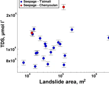
Figure 2.Total dissolved solids (TDSs) in landslide seepage plot-ted against the mapped area of the individual landslides. Analytical error on TDS measurements is shown.
slide (Emberson et al., 2016), but the volume increases at a greater rate (Larsen et al., 2010).
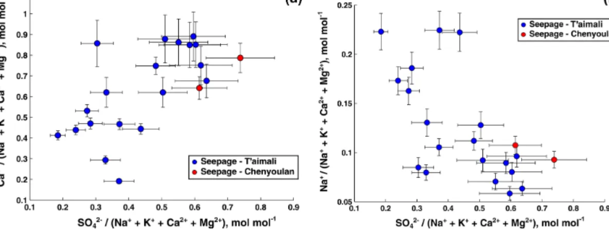
In the T’aimali catchment, there is no strong correlation between landslide size and TDS; R2values for correlation between TDS and landslide area (Fig. 2), and TDS and land-slide volume are 0.11 and 0.09 respectively (p = 0.62 and p =0.70 respectively). This suggests that, here, other factors have an overriding effect on the solute concentration in seep-age from landslides. Notably, we find a strong correlation be-tween the TDS and dissolved sulfate concentration in land-slide seepage (R2=0.88; p < 0.001). This is not unexpected, and could arise from dilution or mixing. However, the ratio of calcium to the sum of other cations (sodium, potassium, mag-nesium, and calcium) is correlated with the ratio of dissolved sulfate to the same cations (Fig. 3a; R2=0.64, p < 0.005), which suggests a change in weathering regime. A decrease in the fraction of sodium to other cations also correlates with the increasing fraction of sulfate (Fig. 3b; R2=0.63, p < 0.005). We attribute these changes to the oxidation of pyrite in the mobilised and fragmented rock mass and an ensuing increase in weathering of carbonates driven by sulfuric acid. Although the sporadic presence of other sulfide minerals, or mineral sulfates, cannot be excluded, this has not been documented in southern Taiwan. Instead, the rapid oxidation of pyrite has previously been observed in the region and elevated TDS concentrations in Taiwan mountain rivers have been viewed in this light (Calmels et al., 2011; Das et al., 2012; Kao et al., 2004). Sulfide oxidation is so prevalent in the larger Kaop-ing Basin (drainKaop-ing the south-western part of Taiwan) that the delivered sulfate is 1.2–1.6 % of global fluxes, from a basin only ∼ 0.003 % of global drainage (Das et al., 2012), and these prior studies link this explicitly to elevated physical disintegration of rock.
Figure 3. (a) Molar ratio of dissolved calcium to sum of dissolved calcium, magnesium, potassium, and sodium (Ca2+/Na++K++ Ca2++Mg2+) plotted against ratio of dissolved sulfate to the same dissolved elements (SO2−4 /Na++K++Ca2++Mg2+). (b) Molar ratio of dissolved sodium to sum of dissolved calcium, magnesium, potassium and sodium (Na+/Na++K++Ca2++Mg2+) plotted against ratio of dissolved sulfate to the same dissolved elements (SO2−4 /Na++K++Ca2++Mg2+). Error bars are the propagated total measurement uncertainty.
The area and volume of landslides varies over 3 and 4 or-ders of magnitude respectively; it is unlikely that the distribu-tion of sulfides in the rock mass varies as much over a short distance. Instead, we suggest that the absence of correlation between size and solute concentration is likely indicative of a limit to advection and diffusion of oxygenated water in land-slides, either linked to the size or the unconstrained internal hydrology. The importance of pyrite in landslide weathering in Taiwan is disproportionate to its relatively minor abun-dance in the overall rock mass (Das et al., 2012; Kao et al., 2004). Instead, its prominent role is determined by its reac-tivity. By introducing significant quantities of fresh rock ma-terial into the surface weathering zone, landslides reset the proportions of individual minerals within this zone to that of the deeper substrate. This differs from weathering linked to soil production, as in many cases the most reactive phases are depleted below the bedrock–regolith interface (e.g. Brantley et al., 2013; Drake et al., 2009).
The majority of the high TDS in landslide seepage is ac-complished through carbonate weathering via either the sul-furic acid derived from pyrite oxidation or carbonic acid. Cal-cium can also be sourced as a product of silicate weather-ing. Whilst silicate-derived potassium does vary with sulfate concentrations, ranging from ca. 20 to 300 µmol L−1 over the measured range of SO2−4 , the lower proportion of other purely silicate-derived cations and silicic acid in landslide seepage (e.g. Na+:Ca2+ratio always < 0.5, compared to the silicate mineral value of 2.85; Calmels et al., 2011) as well as the markedly different behaviour of sodium and calcium (Fig. 3a and b) supports the interpretation that weathering in the sampled landslides is dominated by the dissolution of carbonates.
An implication of our observations is that in the T’aimali catchment, a significant proportion of the sedimentary pyrite
contained within the rock mass survives exhumation and is only exposed by landslide fragmentation at the surface. Pre-vious studies in Taiwan (Calmels et al., 2011) have shown that sulfate is a key component in deep groundwater (sam-pled > 100 m below the surface), but clearly not all pyrite is oxidised at these depths. Groundwater circulating in the bedrock topography is unlikely to be the source of sulfate in seepage. Such water would not systematically surface at landslide sites, given the highly variable morphologic char-acteristics (size, scar / deposit ratio, position with respect to ridge crest and valley floor, and proximity to major faults) of individual landslides. The same argument applies to geother-mal outflow. Moreover, hot spring waters sampled in the T’aimali catchment have extremely high lithium concentra-tions, 1610 µmol L−1, and the lack of elevated Li+ concen-trations in the landslide seepage samples suggests the el-evated sulfate in seepage derives from in situ weathering. Other studies have found high concentrations of silicate-derived cations in deeper groundwater (Calmels et al., 2011); we do not observe any strong increase in the proportion of cations exclusively sourced from silicate minerals (particu-larly sodium – Fig. 3b) and sulfate in landslide seepage. Ex-tremely elevated Na+and Mg2+concentrations at some sites are not clearly associated with any other measured parame-ter, or with each other, and we have no ready explanation for these isolated observations at present. Since these high con-centrations are not linked to dissolved sulfate, they may be linked to flow paths with limited oxygen where sulfate ox-idation cannot proceed, but we do not have a constraint on this.
Overall, we suggest that the spatial heterogeneity of groundwater flow paths in mountain belts (Andermann et al., 2012; Calmels et al., 2011) and extensive tectonic fracturing (Molnar et al., 2007; Clarke and Burbank, 2011; Menzies
et al., 2014) will to some extent preclude the existence of well-defined depletion depths for reactive mineral phases as seen elsewhere (e.g. Brantley et al., 2013; Drake et al., 2009). As such, some reactive phases likely reach the near-surface where landslides can expose them to oxygenated fluid.
5.2 Landslide weathering products in stream water
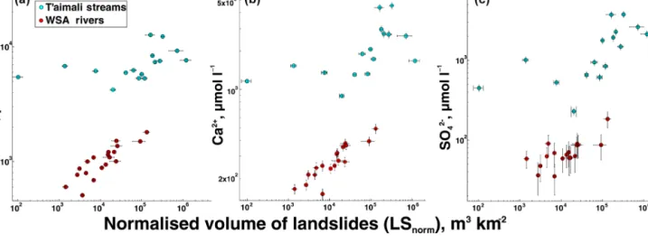
To directly compare the impact of landsliding on weathering in the steep mountains of Taiwan between landscape units with variable landslide activity, we have used the volumes of landslides calculated for each sampled subcatchment within the T’aimali drainage area and normalised to catchment area and evaluated these against the solute load of the streams. For this purpose, we use landslide volume rather than sur-face area because much of the weatherable mineral sursur-face area is contained within the landslide debris rather than at the landslide surface. In doing so, we assume that the hy-draulic connectivity in the groundmass of the landslide is al-ways high enough to wet the mineral surface area within the entire landslide body. We find that TDS and Ca2+increase with increased landslide volumes in the sampled subcatch-ments where the landslide volume density exceeds approxi-mately 104m3km−2of catchment area (Fig. 4). Above this “threshold”, we observe a doubling of TDS from ca. 6000 to more than 12 000 µmol L−1and increases in the concen-tration of Ca2+from ca. 1000 to nearly 5000 µmol L−1, as landslide densities increase up to ca. 106m3km2. There is an increase in the SO2−4 over this same landslide density range, from ca. 300 to nearly 4000 µmol L−1, and as in the individ-ual landslide seepage samples, there is a strong correlation of both stream TDS and dissolved Ca2+concentrations with the dissolved sulfate (R2=0.929 and 0.9318 respectively; p< 0.001 for both relationships). Dissolved Na+ (Fig. 5a) does not systematically vary with SO2−4 (p = 0.74), although K+does increase significantly, from 15 to 130 µmol L−1with sulfate concentration (p < 0.001). At lower specific land-slide volumes, there is a larger degree of variability and be-low 104m3km2, equivalent to a debris layer with a uniform thickness of about 1 cm over the catchment, the stream TDS and Ca2+concentrations do not vary systematically with the landslide volume.
The importance of landsliding in setting the chemical load of streams varies depending on which element is considered. For example, landslides exert a strong control over dissolved calcium and potassium in streams but have almost no impact on dissolved sodium. On the catchment scale, solute concen-trations remain primarily dependent on the additional acid-ity provided by the oxidation of pyrite; coupled carbonate– sulfuric-acid weathering increases the Ca2+output and with it the total exported solute load. On the other hand, dissolved SiO2is unaffected by either increasing landslide volume or
changes in SO2−4 . Notably, values of SiO2 measured in the
streams of the T’aimali catchment can exceed those mea-sured in landslide seepage, suggesting that any
landslide-induced impact on local silicate weathering is not significant enough to outweigh weathering elsewhere, either in soils on stable hillslopes or deeper in the subsurface. Longer flow paths of deep groundwater, reaching well below the levels affected by landsliding, are more likely to be enriched in slower dissolving silicate weathering products (Bickle et al., 2015; Calmels et al., 2011; Galy and France-Lanord, 1999), and the relatively low fraction of sodium and silicic acid in landslide seepage suggests a comparatively short water resi-dence time in mass wasting deposits (Maher, 2011). In view of this, we posit that the disconnection between stream-borne sulfate and some silicate weathering products (Na+, silicic acid), juxtaposed with a link of sulfate and potassium, which is also only sourced from silicate, reflects the existence of multiple pathways relevant for silicate weathering on a catch-ment scale. More congruent weathering in deep groundwater likely complements the rapid weathering of carbonates and incongruent weathering of silicates (such as rapid K+release
from chlorite and biotite; Malmstrom et al., 1996) in mass wasting deposits.
The sampled subcatchments have up to 16.6 % of the total area occupied by landslide deposits and scars. However, the T’aimali watershed contains some exceptionally large land-slides, the outlines of which define tributary catchments in their own right. The largest landslide we sampled (TWS15-46) has a surface area of 2.7 km2. On these very large scales and where landsliding has affected such an important part of the topography, the distinction between landslide and stream catchment becomes blurred, and solute concentrations from such catchments will also be subject to the same limits on TDS concentrations in the landslides themselves. The peak TDS values we measured in seepage are between 15 000 and 20 000 µmol L−1. Other locations may have greater concen-trations, if local weathering has greater oxidation of sulfides, either due to more efficient distribution or oxygenated water at depth in the landslide deposit. Such hypothetical, very high concentrations, in excess of what we have recorded, would serve as an upper limit to solute concentrations in the entire catchment.
Even where landsliding is less prominent, there is still sig-nificant variability in tributary stream dissolved load (Fig. 4). This is unlikely to be an artefact of the mapping; landslides below the detection limit (about 500 m2) are unlikely to mine significant quantities of bedrock. Instead, they primarily mo-bilise colluvial or soil material, which limits their impact via the oxidation of sulfides. Meanwhile, other environmen-tal factors that result in variability in TDS at higher land-slide rates will also apply to the steep mountain landscape of southern Taiwan in the absence of landslides. This includes variable oxidation of pyrite in a tectonically fractured sub-strate, which will affect both deep and shallow groundwater fluxes, depending on where in the weathering zone the re-spective hydrological flow paths are located. Other studies have incorporated topographic factors, such as local slope or hillslope length, into the models of weathering (Heimsath
Figure 4.Normalised volume of landslides (calculated volume divided by catchment area) plotted against total dissolved solids (TDSs, a), dissolved calcium (Ca2+, b), and dissolved sulfate (SO2−4 , c) for streams in the T’aimali River (this study) and previous numbers for catchments in the western Southern Alps (WSA) of New Zealand (Emberson et al., 2016). Vertical error bars are total measurement uncertainty; horizontal error bars are 95 % confidence intervals for volumes. Each chemical measurement has been corrected for cyclic and hydrothermal input.
et al., 1997; Maher and Chamberlain, 2014). These factors may also be a source of variability in subcatchments with low landslide rates. However, landsliding during Typhoon Morakot was primarily controlled by the intensity and vol-ume of rainfall (Lin et al., 2011), and the pattern of lands-liding in the T’aimali catchment is not strongly tied to to-pographic characteristics. Hence, the amount of mass wast-ing in individual sub-catchments is not strongly related to the local modal slope (see data in Table 2). Moreover, nei-ther modal slope nor the range of elevation in a catchment is correlated with the measured TDS, suggesting these factors do not strongly control the weathering in this setting.
Many subcatchments of the T’aimali watershed contain significant amounts of alluvial material, which derives from landslide debris delivered to streams. Alluviated streambeds could be a locus of enhanced weathering, but we do not ob-serve any correlation between the measured stream chem-istry and the proportion of the catchment filled with allu-vial material in the six subcatchments with significant fill (> 1 % of total catchment area – see Table 1; R2= −0.365; Kendall’s Tau = −0.067; p = 0.48). However, due to the lack of rainfall prior to and during the sampling period, we were unable to sample hyporheic water from within the alluvial streambeds. The presence of secondary precipitates in fill deposits suggests that at low flow these sedimentary bodies could act as sinks for solutes rather than sources. Although the role of alluvial materials in the weathering budget of the T’aimali catchment is not fully clear, our observations sug-gest that it is not a first-order control on the chemical output during the sampling interval.
As we did not measure the discharge in these small streams, we can only report concentrations of solutes.
Weather-determined dilution could affect the measured so-lute concentrations and cause them to vary between catch-ments. However, observations from other parts of the Tai-wanese mountains (Calmels et al., 2011; Lee et al., 2015) suggest that dissolved calcium concentrations are only di-luted by more than approximately 35 % during peak typhoon discharge conditions in mountain rivers. Therefore, we ex-pect that although the period when we sampled was rela-tively dry, our measurements are a fair first-order represen-tation of solute concentrations and ratios during the major-ity of the year. This is consistent with observations from other mountain belts, including the Southern Alps of New Zealand, the Himalayas, and the Andes, where rivers exhibit near-chemostatic behaviour over a range of discharge con-ditions (Lyons et al., 2005; West et al., 2005; Torres et al., 2015; Tipper et al., 2006).
5.3 Landsliding and the weathering of labile minerals
Solute concentrations in landslide seepage and stream water in the T’aimali catchment are significantly higher than in the rivers of the WSA by approximately 5–10 times (Fig. 4a). Both locations share a steep, landslide-dominated mountain physiognomy and very high rainfall rates, but Taiwan is warmer and has carbonate-rich, pyrite-bearing lithologies, whereas the WSA formations have only trace amounts of these minerals. We suggest that lithology and climate set a baseline for weathering in a given setting, above which landslides can control the weathering variability. This con-trol is especially clearly expressed in the WSA, where the substrate for weathering is relatively homogeneous. The Tai-wanese river chemistry has a larger spread with respect to landslide volumes, but the clear correlation between stream
Figure 5. (a) Dissolved sulfate (SO2−4 ) plotted against total dis-solved solids (TDSs, above) and (b) disdis-solved sodium (Na+, below) in streams in the T’aimali River. Error bars are total measurement uncertainty.
TDS and SO2−4 (Fig. 5a, R2=0.93, p < 0.001) reflects the importance of the weathering occurring within the landslides in setting catchment-scale river solute concentrations. It is unlikely that this correlation arises from the dilution or mix-ing of sources. The lack of correlation between sodium and sulfate concentrations (Fig. 5b, p = 0.74) rules out a strong influence of both dilution and evapotransporation and likely precludes weathering pathways with elevated sulfate and sil-icate weathering such as deeper groundwater from contribut-ing to the higher TDS. Heterogeneous distribution of sulfides in the bedrock substrate of the T’aimali catchment and its variable oxidation during exhumation likely not only affect the individual landslide seepage concentrations but also the chemistry of streams throughout the catchment. This may ex-plain why the total volume of landslides is a weaker control over stream TDS than in New Zealand.
Reactions of the most labile mineral phases dominate the chemistry of landslide seepage. In the T’aimali catchment and elsewhere in Taiwan, the fastest reaction is the oxidation
of sulfide. In the case of the WSA, elevated landslide seepage concentrations (Emberson et al., 2016) result from weather-ing of small amounts of highly labile carbonate, which be-come exposed through rock mass fragmentation. However, unlike the T’aimali, the fragmentation of WSA bedrock does not introduce an extra source of acidity. The relative abun-dance of carbonate in Taiwan means fluids are supersatu-rated everywhere with respect to calcite (Table 1). Therefore, the potential for landsliding to increase carbonate weathering due to rock mass fragmentation would be limited but for the exposure of pyrite and the associated generation of sulfuric acid. Thus, exposure of reactive minerals due to rock mass fragmentation boosts weathering rates in landslides, but the minerals and their roles vary between settings. The concept of a reaction front for weathering is less applicable to these settings, as the distribution of reactions will be controlled by the localisation of detrital sulfides and the flow paths provid-ing oxygenated fluid.
Landslide weathering rates will remain elevated until the relevant reactive mineral(s) have been depleted, after which weathering in landslides is likely to proceed much like in other parts of the landscape, driven by organic and carbonic acids. The initial abundance of trace sulfide and/or carbon-ate together with their exhaustion, over longer timescales, is likely to be an important control on the duration of rapid weathering in landslides. However, in choosing the T’aimali catchment, where the vast majority of the mass wasting ob-served occurred very recently and all at once, we have also selected a location where the long-term impact of rock mass fragmentation in landslides is difficult to observe. Neverthe-less, some constraints may be gleaned from two subcatch-ments (TWS15-40 and TWS15-53) where the TDS and dis-solved SO2−4 values are lower than others with a similarly high landslide incidence (TWS15-40 (9220 µmol L−1) and TWS15-53 (7617 µmol L−1) compared to other streams with TDS greater than 12 000 µmol L−1). These two subcatch-ments have large landslides that had been moving persis-tently for at least 2 decades prior to Typhoon Morakot. Al-though these landslides were reactivated during the typhoon, they likely displaced materials that had already been sig-nificantly depleted of pyrite due to prior fragmentation and weathering. This is circumstantial evidence of a substantial loss of weathering intensity by depletion of especially labile minority minerals on a decadal timescale in this instance, similar to previous findings in the WSA (Emberson et al., 2016).
A second timescale of relevance is that of the physical moval of landslide debris from the catchment. If debris re-mains in a catchment after the depletion of exposed pyrite, then its weathering will revert to mineral reactions with car-bonic acid. If the time to depletion is greater than the time required for removal of the debris, then the labile phases it contains will remain unweathered and will be removed through sediment transport processes. In the case of Taiwan,
some samples of riverbed material show sulfur content of up to 1.07 % (Hilton et al., 2014), suggesting that weather-ing in the landscape does not purge all sulfides brought to the surface by rock mass exhumation. In the opposite case the weathering from a given landslide will return to a con-stant background rate shared with other colluvium and soil covered parts of the landscape. How this scales up to the catchment scale depends on the return time of large drivers of mass wasting, such as typhoons and earthquakes and the subsequent advection of debris into the fluvial network and the transport capacity of this network. A disparity between short-term production of sediment on hillslopes and the ca-pacity for onward transport can lead to up to millennial res-idence times of event-produced sediment in mountain land-scapes (Blöthe and Korup, 2013). In the T’aimali catchment, many headwater streams were still clogged with sediment 6 years after Typhoon Morakot, and large colluvial fans had formed below several landslide-dominated tributaries. Else-where in Taiwan, mountain valleys contain large colluvial terraces, which have formed hundreds to thousands of years ago (Hsieh and Chyi, 2010). This implies that timescales of pyrite depletion and of debris removal must both be consid-ered in further explorations of the links between erosion and weathering in Taiwan.
5.4 Impact on climate
The link between weathering and atmospheric pCO2is
de-termined by the mineralogy of the weathered substrate, the composition of the weathering acid, and the residence time of material in the weathering zone (Torres et al., 2016; Galy and France-Lanord, 1999; Lerman et al., 2007). Therefore, the balance of silicate–carbonate weathering, the source of acidity in mass wasting deposits and the retention of these sediments in the landscape are all crucial to the role of land-sliding in the carbon cycle. As a result of this complexity, the impact of landsliding on climate is ambiguous. Weath-ering of silicates with carbonic acid can lower the atmo-spheric pCO2, but with sulfuric acid it has no effect.
Disso-lution of carbonates has no net effect on atmospheric pCO2
if achieved with carbonic acid, and it can increase pCO2if
it is accomplished with sulfuric acid (Calmels et al., 2007; Gaillardet et al., 1999; Torres et al., 2014). As erosion rates increase and mass wasting through bedrock landsliding be-gins to dominate erosional budgets, the erosional impact on CO2and climate, achieved through sustained weathering of
silicates (Berner and Kothavala, 2001; Brady, 1991; Raymo and Ruddiman, 1992), will weaken. Weathering of carbon-ates will form a greater portion of solute budgets, even where they are only present in small amounts, and in mountain belts where pyrite is ubiquitous, erosion-driven weathering may even become a source of CO2(e.g. Calmels et al., 2007;
Tor-res et al., 2016).
The length of time over which sediment is stored in a catchment will determine the cumulative effect of this
weath-ering. In Taiwan, storage times of greater than 50 kyr have been demonstrated for sedimentary terraces derived from mass wasting (Hsieh and Capart, 2010; Hsieh and Chyi, 2013). In such locations, where the retention time of sedi-ment derived from mass wasting is long compared to the de-cay time of the weathering boost provided by the highly la-bile minerals contained initially in these sediments, the cou-pled sulfuric-acid–carbonate weathering will likely be super-seded by slower silicate weathering, reducing any net release of CO2. When the sediment retention time equals the
weath-ering boost decay time, the effect of landsliding on CO2
re-lease is maximised. Shorter sediment residence times pro-mote the export of unweathered sediment to the ocean and its burial in marine basins. This can result in a fraction of sulfides contained in the rock mass bypassing the weather-ing window (Hilton et al., 2014), reducweather-ing the potential ef-fect of their exhumation on atmospheric pCO2and returning
the landscape to a state in which distributed weathering in soils and colluvial fills dominates. In addition to this inor-ganic complexity, the export and burial of orinor-ganic carbon via landsliding also has an impact on the carbon budget of Tai-wan (Hilton et al., 2008, 2011; West et al., 2011). Ultimately, quantification of the processes side-by-side is important to understanding the role of mountain erosion in the Earth’s car-bon cycle.
In the T’aimali catchment – a good analogue for many young mountain belts formed of continental margin sed-iments – widespread, typhoon-triggered landsliding has caused a significant increase in carbonate weathering by sul-furic acid over timescales shorter than the return time of ex-treme meteorological drivers of mass wasting. As a result, the area most affected by erosion due to Typhoon Morakot could be a net source of CO2to the atmosphere. The weathering
boost is likely to end before the next major meteorological perturbation of southern Taiwan, so that the weathering of carbonates and silicates with carbonic acid must be taken into account when considering the longer-term effects of erosion in south Taiwan. Future work to quantify the net sequestra-tion or release of CO2would require a closer evaluation of
the ratios of acid at work, as well as correction for the exten-sive secondary precipitation evident in the catchment.
6 Conclusions
Landslides can mobilise and fragment large volumes of rock mass from below the soil and regolith mantle of steep hill-slopes. Weathering of this material is promoted by the expo-sure of fresh rock to infiltrating water and oxygen in landslide debris with very high internal surface area. Under these con-ditions, weathering is limited by the kinetics of the reactions of the most labile mineral phases, but as long as these phases are abundant in the rock mass, the rate of weathering is vastly increased. We have found that these labile phases may be mi-nority constituents, driving the weathering in fresh landslide
deposits away from the slower process affecting the surface materials elsewhere in the landscape over longer timescales. In southern Taiwan, weathering in landslides triggered during Typhoon Morakot in 2009 is governed by the rapid oxidation of pyrite, which is a trace mineral in the pelitic rocks of the local substrate. This oxidation generates sulfuric acid, which reacts primarily with ubiquitous carbonates. Five years after landsliding, carbonic acid is a weathering agent of lesser importance, while the weathering of silicate miner-als is not elevated. In the T’aimali catchment in south-east Taiwan, which sustained landsliding at spatially diverse rates during Typhoon Morakot, stream chemistry suggests that landslides have tapped into rock mass with variable amounts of pyrite. Although total dissolved solids concentrations in tributary streams vary with the landslide density in their sub-catchments, they are better correlated with the sulfate con-centration. In rare subcatchments where older landslides, dat-ing back at least 25 years, dominate, TDS and sulfate con-centrations are markedly lower, indicating that the effects of exposure and oxidation of pyrite in landslides may dissipate on decadal timescales in this area.
Southern Taiwan sits within a rapidly deforming and up-lifting mountain belt, formed with calcareous sandstones and pelites from the Asian continental margin. It shares its deformation style and a range of lithologies with many other young mountain belts at convergent plate boundaries. Bedrock landsliding is the dominant mode of mass wasting and sediment production in such settings. Therefore, we sub-mit that our observations of landslide weathering in Taiwan may well have wider implications. Moreover, even where pyrite is not significantly present, the importance of labile mineral phases in weathering in recent landslide deposits is evident. In the western Southern Alps of New Zealand, the rapid reaction of carbonates, which make up only a very small fraction of the rock mass, carbonic acid dominates the chemistry of landslide seepage and helps set the weathering flux from the mountain belt (e.g. Jacobson et al., 2003; Em-berson et al., 2016). The combination of results from these two settings suggests that landslides may affect weathering in other rapidly denuding mountain belts, albeit modulated by lithology.
Hence, in order to understand chemical weathering rates from mountain belts where erosion is dominated by stochas-tic mass wasting, it is crucial to consider the way in which this specific erosive process controls weathering. We propose a conceptual model of a rapidly eroding landscape where the background weathering is set by lithology and climate, over-printed by the impact of landslides. The importance of re-active mineral phases, weathering rapidly in small and spe-cific parts of the landscape affected by deep-seated erosion, is a contrast to existing concepts, which do not encompass the stochastic nature of weathering (Dixon and von Blanck-enburg, 2012; Maher and Chamberlain, 2014; Riebe et al., 2003). A full description of the impact of landsliding on weathering should include the effect on the availability of
reactive phases in addition to the previously modelled spatial stochasticity (Gabet, 2007).
Ultimately, the importance and impact of landslide weath-ering will be determined by the rate of the geomorphic pro-cess and the mineral composition of the substrate in which it occurs. However, it will also depend on the efficiency with which the products of mass wasting are removed from the landscape and transferred into geological basins, relative to the time needed to leach the most labile mineral phases from the mobile sediment and to the return time of important mass wasting events in the landscape. In this light, we draw at-tention to the possibility that disproportionate dissolution of highly labile mineral phases such as pyrite or carbonate as a result of landslide-driven weathering may reduce the strength of the link between erosion and atmospheric CO2drawdown
via silicate weathering in fast eroding settings, which in turn would modulate any feedback on erosion through changes in tropical storm intensity (e.g. Knutson et al., 2010). The role of active mountain belts in the global carbon cycle remains ambiguous.
7 Data availability
All analyses described in the text are reproducible with the data listed in Tables 1 and 2. Samples locations are provided in the tables, allowing for field replication.
Acknowledgements. We thank Meng-Long Hsieh and several of his students for sampling support and local knowledge in Taiwan. Assistance from Barney Ward, Claire Nichols, and Kristen Cook greatly aided field campaigns. Carolin Zorn measured the anion content of the samples, and Rene Mania significantly improved landslide maps for Taiwan covering the last 20 years. Discussion with Friedhelm von Blanckenburg and Josh West aided the development of the paper. R. Emberson, N. Hovius, and A. Galy conceived the study; R. Emberson, N. Hovius, and O. Marc collected samples; O. Marc generated landslide data; R. Emberson wrote the paper with major input from all authors. Three anonymous reviewers greatly aided the development of the manuscript with constructive commentary. R. Emberson has benefited from Helmholtz Institutional funding during this project. Edited by: J. Willenbring
Reviewed by: three anonymous referees
References
Andermann, C., Longuevergne, L., Bonnet, S., Crave, A., Davy, P., and Gloaguen, R.: Impact of transient groundwater storage on the discharge of Himalayan rivers, Nat. Geosci., 5, 127–132, doi:10.1038/ngeo1356, 2012.
Berner, R. A. and Kothavala, Z.: GEOCARB III; a revised model of atmospheric CO2over Phanerozoic time, Am. J. Sci., 301, 182– 204, doi:10.2475/ajs.294.1.56, 2001.
Bickle, M. J., Tipper, E. T., Galy, A., Chapman, H., and Har-ris, N.: On Discrimination Between Carbonate and Silicate Inputs to Himalayan Rivers, Am. J. Sci., 315, 120–166, doi:10.2475/02.2015.02, 2015.
Blöthe, J. H. and Korup, O.: Millennial lag times in the Himalayan sediment routing system, Earth Planet. Sc. Lett., 382, 38–46, doi:10.1016/j.epsl.2013.08.044, 2013.
Brady, P. V.: The effect of silicate weathering on global tempera-ture and atmospheric CO2, J. Geophys. Res., 96, 18101–18106,
doi:10.1029/91JB01898, 1991.
Brantley, S. L., Holleran, M. E., Jin, L., and Bazilevskaya, E.: Prob-ing deep weatherProb-ing in the Shale Hills Critical Zone Observatory, Pennsylvania (USA): The hypothesis of nested chemical reaction fronts in the subsurface, Earth Surf. Proc. Land., 38, 1280–1298, doi:10.1002/esp.3415, 2013.
Calmels, D., Gaillardet, J., Brenot, A., and France-Lanord, C.: Sustained sulfide oxidation by physical erosion processes in the Mackenzie River basin: Climatic perspectives, Geology, 35, 1003, doi:10.1130/G24132A.1, 2007.
Calmels, D., Galy, A., Hovius, N., Bickle, M., West, a. J., Chen, M.-C., and Chapman, H.: Contribution of deep groundwater to the weathering budget in a rapidly eroding mountain belt, Taiwan, Earth Planet. Sc. Lett., 303, 48–58, doi:10.1016/j.epsl.2010.12.032, 2011.
Central Geological Survey, Ministry of Economic Affairs: Geologic Map of Taiwan, 2000.
Chamberlain, C. P., Waldbauer, J. R., and Jacobson, A. D.: Stron-tium, hydrothermal systems and steady-state chemical weather-ing in active mountain belts, Earth Planet. Sc. Lett., 238, 351– 366, doi:10.1016/j.epsl.2005.08.005, 2005.
Cheng, M.-C. and You, C.-F.: Sources of major ions and heavy metals in rainwater associated with typhoon events in southwestern Taiwan, J. Geochem. Explor., 105, 106–116, doi:10.1016/j.gexplo.2010.04.010, 2010.
Chien, F. C. and Kuo, H. C.: On the extreme rainfall of Typhoon Morakot (2009), J. Geophys. Res., 116, 1–22, doi:10.1029/2010JD015092, 2011.
Clarke, B. A. and Burbank, D. W.: Quantifying bedrock-fracture patterns within the shallow subsurface: Implications for rock mass strength, bedrock landslides, and erodibility, J. Geophys. Res.-Earth, 116, F04009, doi:10.1029/2011JF001987, 2011. CWB (Central Weather Bureau): Daily Precipitation records,
avail-able at: http://www.cwb.gov.tw/V7e/climate/dailyPrecipitation/ dP.htm, last access: 25 May, 2016.
Dadson, S. J., Hovius, N., Chen, H., Dade, W. B., Hsieh, M.-L., Willett, S. D., Hu, J.-C., Horng, M.-J., Chen, M.-C., Stark, C. P., Lague, D., and Lin, J.-C.: Links between erosion, runoff variabil-ity and seismicvariabil-ity in the Taiwan orogen, Nature, 426, 648–651, doi:10.1038/nature02150, 2003.
Dadson, S. J., Hovius, N., Chen, H., Dade, W. B., Lin, J.-C., Hsu, M.-L., Lin, C.-W., Horng, M.-J., Chen, T.-C., Milliman, J., and Stark, C. P.: Earthquake-triggered increase in sediment delivery from an active mountain belt, Geology, 32, 733–736 doi:10.1130/G20639.1, 2004.
Das, A., Chung, C.-H., and You, C.-F.: Disproportionately high rates of sulfide oxidation from mountainous river basins of Tai-wan orogeny: Sulfur isotope evidence, Geophys. Res. Lett., 39, L12404, doi:10.1029/2012GL051549, 2012.
Dixon, J. L. and von Blanckenburg, F.: Soils as pacemakers and limiters of global silicate weathering, C. R. Geosci., 344, 597– 609, doi:10.1016/j.crte.2012.10.012, 2012.
Drake, H., Tullborg, E. L., and MacKenzie, A. B.: Detect-ing the near-surface redox front in crystalline bedrock using fracture mineral distribution, geochemistry and U-series disequilibrium, Appl. Geochem., 24, 1023–1039, doi:10.1016/j.apgeochem.2009.03.004, 2009.
Emberson, R., Hovius, N., Galy, A., and Marc, O.: Chemical weath-ering in active mountain belts controlled by stochastic bedrock landsliding, Nat. Geosci., 9, 42–45, doi:10.1038/NGEO2600, 2016.
Ferrier, K. L. and Kirchner, J. W.: Effects of physical erosion on chemical denudation rates: A numerical modeling study of soil-mantled hillslopes, Earth Planet. Sc. Lett., 272, 591–599, doi:10.1016/j.epsl.2008.05.024, 2008.
Fuller, C. W., Willett, S. D., Hovius, N., and Slingerland, R.: Erosion Rates for Taiwan Mountain Basins: New Determi-nations from Suspended Sediment Records and a Stochas-tic Model of Their Temporal Variation, J. Geol., 111, 71–87, doi:10.1086/344665, 2003.
Gabet, E. J.: A theoretical model coupling chemical weathering and physical erosion in landslide-dominated landscapes, Earth Planet. Sc. Lett., 264, 259–265, doi:10.1016/j.epsl.2007.09.028, 2007.
Gaillardet, J., Dupré, B., Louvat, P., and Allegre, C.: Global silicate weathering and CO2consumption rates deduced from the
chem-istry of large rivers, Chem. Geol., 159, 3–30, doi:10.1016/S0009-2541(99)00031-5, 1999.
Galloway, J. N., Likens, G. E., Keene, C., and Miller, J. M.: The composition of precipitation in remote areas of the world, J. Geophys. Res.-Oceans, 87, 8771–8786, doi:10.1029/JC087iC11p08771, 1982.
Galy, A. and France-Lanord, C.: Weathering processes in the Ganges–Brahmaputra basin and the riverine alkalinity budget, Chem. Geol., 159, 31–60, doi:10.1016/S0009-2541(99)00033-9, 1999.
Hartmann, J. and Moosdorf, N.: The new global lithological map database GLiM: A representation of rock properties at the Earth surface, Geochem. Geophys. Geosy., 13, 1–37, doi:10.1029/2012GC004370, 2012.
Heimsath, A. M., Dietrich, W. E., Nishiizumi, K., and Finkel, R. C.: The soil production function and landscape equilibrium, Nature, 388, 21–24, 1997.
Hilley, G. E., Chamberlain, C. P., Moon, S., Porder, S., and Wil-lett, S. D.: Competition between erosion and reaction kinetics in controlling silicate-weathering rates, Earth Planet. Sc. Lett., 293, 191–199, doi:10.1016/j.epsl.2010.01.008, 2010.
Hilton, R. G., Galy, A., and Hovius, N.: Riverine particu-late organic carbon from an active mountain belt: Impor-tance of landslides, Global Biogeochem. Cy., 22, GB1017, doi:10.1029/2006GB002905, 2008.
Hilton, R. G., Meunier, P., Hovius, N., Bellingham, P. J., and Galy, A.: Landslide impact on organic carbon cycling in a tem-perate montane forest, Earth Surf. Proc. Land, 36, 1670–1679, doi:10.1002/esp.2191, 2011.
Hilton, R. G., Gaillardet, J., Calmels, D., and Birck, J. L.: Geological respiration of a mountain belt revealed by the