HAL Id: hal-01306059
https://hal-brgm.archives-ouvertes.fr/hal-01306059
Submitted on 22 Apr 2016HAL is a multi-disciplinary open access
archive for the deposit and dissemination of sci-entific research documents, whether they are pub-lished or not. The documents may come from teaching and research institutions in France or abroad, or from public or private research centers.
L’archive ouverte pluridisciplinaire HAL, est destinée au dépôt et à la diffusion de documents scientifiques de niveau recherche, publiés ou non, émanant des établissements d’enseignement et de recherche français ou étrangers, des laboratoires publics ou privés.
Surface water – groundwater interactions in alluvial
contexts: constraints using single and multi-isotope
tracers
Emmanuelle Petelet-Giraud, Philippe Négrel, Nicole Baran, Maritxu
Saplairoles, Lise Cary, Wolfram Kloppmann, Agnès Brenot
To cite this version:
Emmanuelle Petelet-Giraud, Philippe Négrel, Nicole Baran, Maritxu Saplairoles, Lise Cary, et al.. Surface water – groundwater interactions in alluvial contexts: constraints using single and multi-isotope tracers. 35th International Geological Congress : IGC 2016, Aug 2016, Cape Town, South Africa. �hal-01306059�
Surface water – groundwater interactions in alluvial contexts: constraints
using single and multi-isotope tracers
Petelet-Giraud, E.
1, Négrel, Ph.
1, Baran, N.
1, Saplairoles, M.
2, Cary, L.
3, Kloppmann, W.
1Brenot, A.
4*1BRGM (French Geological Survey), Laboratory Division, BP 36009, 45060 Orleans, France; [email protected] 2BRGM, Toulouse Agency, 31520 Ramonville-Saint-Agne, France
3
BRGM, Lille Agency, 59260 Lezennes, France 4
BRGM, Lyon Agency, 69100 Villeurbanne, France; *Present address: EDF, 38040 Grenoble, France
___________________________________________________________________________
Surface water and groundwater have been considered as separate waters bodies for a long time by hydrologists and also decision makers, so that the relevance of interconnections between groundwater and surface water has frequently been underestimated. Since the last decades, rivers and aquifers are no more considered as physically independent entities, and are now approached as integral components of an aquifer-river-continuum with strong mutual influences between river, aquifer and the interconnecting hyporheic zone. Numerous research approaches were developed to identify and quantify the river-aquifer exchanges that can be in both directions depending on the river profile and the seasonal water levels and hydraulic gradients. The understanding of the links between hydrological, biogeochemical, and ecological process dynamics in hyporheic zones and their implications for river water quality and ecology are also of major concern for water management and decision makers.
Among the existing investing methods of surface water and groundwater relations, isotope techniques constitute a powerful approach; stable isotopes δ18O and δ2H being the most commonly used intrinsic “ideal” tracers of the water molecule.
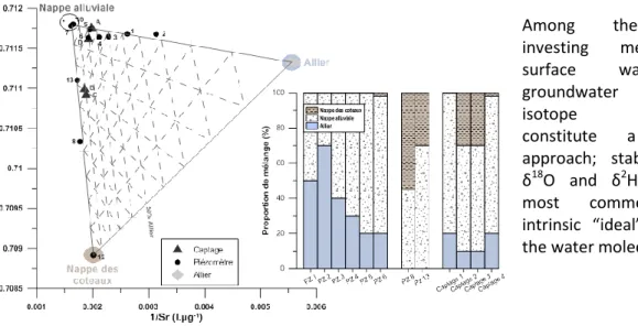
Figure 1: Strontium isotopes to evidence and quantify mixings from various origins (Allier, France)
Furthermore, isotopes of dissolved elements (Sr, B, S, …) also constitute valuable tracers to identify and, in optimal conditions, to quantify the exchanges between surface- and ground-water bodies. Through various examples we present the contribution of isotopic tracers to our understanding of groundwater recharge in alluvial valley-fillings, riverbank aquifers counting worldwide among the most important water resources for drinking water supply, irrigation and industrial activities. Sr isotopes are excellent tracers of water-rock interactions as 87Sr/86Sr reflect the signature of the minerals that constitute the drained aquifer lithologies. Boron isotopes also differ according to the drained lithologies, but, contrarily to strontium, signatures can be affected by secondary processes like adsorption/desorption onto clays; in an urban context, they are good tracers of wastewaters whose signature are characteristic of the boron origin used in detergents. Sulphur and oxygen isotopes of sulphates are also potential tracers of drained lithologies (solid sulphates in evaporites, sulphides in igneous and sedimentary rocks) in cases where fertilizers do not provide the majority of dissolved SO4. The understanding of surface- and ground-water relations, gained through a
multi-tracer approach, can thus explain groundwater quality but also the spatial variability of surface water quality along a river section, information of primary importance for water managers.