Collaborative Environments for Disaster Relief
byYusuke Mizuno
M.Eng., Civil Engineering University of Tokyo, 2000Submitted to the Department of Civil and Environmental Engineering In Partial Fulfillment of the Requirements for the Degree of Master of Engineering in Civil and Environmental Engineering
at the
Massachusetts Institute of Technology
June 2001
( 2001 Yusuke Mizuno, All rights reserved
The author hereby grants to MIT permission to reproduce and to distribute publicly paper and electronic copies of this thesis document in whole or in part.
Sign atu re o f A u th o r: ...
Department of Civil and Environmental Engineering --
C) May 11, 2001
C ertified b y : ... . ...
Feniosky Pefia-Mora Associate Professor of Civil and Environmental Engineering Thesis Supervisor
A ccepted by: ... . . .. ... Oral Buyukozturk Chairman, Dep rtmental Committee on Graduate Studies
MASSACHUSETTS INSTITUTE
Collaborative Environments for Disaster Relief by
Yusuke Mizuno
Submitted to the Department of Civil and Environmental Engineering on May 11, 2001 in Partial Fulfillment of the Requirements
for the Degree of Master of Engineering in Civil and Environmental Engineering
ABSTRACT
In a large-scale disaster relief mission, a variety of personnel and organizations with different expertise take part in the relief activities towards a common goal. Interactions between them are important to promote efficiency, and the relief activities, especially search and rescue (SAR) activities, are carried out in a short time period.
Some Emergency Offices of City/State/Federal governments and two case studies of actual disaster relief activities after large earthquakes were examined in order to recognize the issues in terms of collaborative environments during a disaster relief missions. These examinations have revealed the fact that the availabilities of site-specific information is a major concern when some decisions concerning relief activities are made, but the communication between on-site personnel and headquarters is not enough mainly due to the lack of cross-organizational coordination.
Several commercial solutions have been developed and several studies have been made on collaborative environments at MIT. The current typical solutions consist of e-mail system, group discussion, bulletin board system, and shared data repositories integrated with
mapping systems. Some further enhancements of these systems should be considered: multiple client access and detail design of thin portable client devices.
To develop collaborative environments for disaster relief missions, the requirements have been gathered and the requirement analysis has been developed. According to functional role, relief mission participants are classified into four groups: field agent, team leader, coordinator, decision maker and specialist/advisor. The category "field agent" plays an integral role during a mission so that its activities are focused on. The hierarchy of collaborative session has been developed on account of that of participant roles.
The multiple device access is an important functionality of collaborative environments. Some of the leading portable devices are featured and three types of wireless communication are described. To collect and report site-specific information in a disaster area is critical to make decisions. The needs and requirements of robot-human interaction that can be applied to a relief mission are discussed in comparison with SAR dogs.
ACKNOWLEDGEMENT
I would like to thank Professor Feniosky Pefia-Mora for his detailed comments, suggestions, and constant support during the entire time duration of this study. I am also grateful to Chang Kuang and Wei Wang for their advice.
TABLE OF CONTENTS
1. Introduction...10 1.1 Background ... 10 1.2 Problem s...11 1.3 O bjectives ... 12 1.4 A pproach ... 132. D isaster R elief M ission ... 14
2.1 Search and R escue M ission ... 14
2.2 Local O perations: San Francisco... 15
2.3 Local O perations: N ew Y ork City ... 16
2.4 Federal O perations: FE M A ... 16
2.5 Large-Scale D isaster: K obe E arthquake... 18
2.5.1 D am age D escription ... 18
2.5.2 SA R A ctivities...19
2.6 Large-Scale D isaster: Turkey E arthquake... 21
2.6.1 D am age D escription ... 21
2.6.2 SA R A ctivities ... 22
3. Collaborative Environment for Emergency Management ... 23
3.1 E IS/G E M Infobook...23
3.2 R esponse Inform ation M anagem ent System (RIM S)...26
3.3 E T eam ... 28
3.4 Lotus Solutions ... 31
3.4.1 Lotus D om ino ... 33
3.4.2 Lotus N otes...34
3.4.2 M obile A ccess to Lotus Services... 35
3.5 Collaborative E nvironm ent at M IT ... 37
3.5.1 M eeting structure...37
3.5.2 Inform ation Policies... 38
3.5.3 M eeting Protocols ... 38
3.6 Collaborative E nvironm ent at D raper ... 39
3.6.1 M ission Planning A pplications... 40
3.6.3 M ultiple D evice Interface...41
3.7 C ollaboration betw een M IT and D raper ... 42
4. Em ergency M anagem ent System D evelopm ent ... 43
4.1 Scenario... ... ... ... ---...- 43
4.1.1 Participants ... ... . ---.... ---...---- - 43
4.1.2 R ole D escription... .-- 46
4.2 System O verview ... ... ... --- ... ... 48
4.2.1 D evice and N etw ork Lim itation ... 48
4.2.2 System O verview D escription...49
4.3 U se C ase... ... 50
4.3.1 G lossary ... ... ... ... 50
4.3.2 D iagram ... 51
4.4 Collborative E nvironm ent D ata Flow ... 54
4.5 C ollaboration System Requirem ents...57
4.5.1 Structured C ollaborative Environm ent... 57
4.5.2 R epresentation of Collaborators ... 61
4.5.3 Abstracted Information Policy and Protocol Enforcement ... 62
4.5.4 Persistence of C ollaboration D ata ... 62
4.6 System A rchitecture ... 63
4.6.1 Client A pplication ... 66
4.6.2 Inform ation Policy ... 70
4.6.3 D ata Repository...72
4.6.4 C ollaboration M anager ... 73
4.6.7 Custom C om ponents...75
5. M ultiple D evice A ccess...-77
5.1 D esktop E nvironm ent...77
5.2 Portable PC ...--..- 77
5.3 Personal D egital A ssistant... 80
5.4
Java-E
nable Phone ... 825.4.1 Java 2 Platform , M icro E dition ... 82
5.4.2 Java-enabled Phone Service ... 83
5.4.1 W ireless W A N ... 85
5.4.2 W ireless ILA N ... 86
5.4.3 W ireless PA N ... 86
6. Robot-H um an. Interaction ... 87
6.1 O verview ... 87
6.2 Requirem ents ... 87
6.3 LEG O M IN D STO RM S ... 88
6.3.1 Progranuning Environm ent ... 89
6.3.2 Input: Sensors ... 89
6.3.3 O utput ... 89
6.4 jini Technology ... 89
LIST OF FIGURES
Figure 1.1: Number of people rescued/searched by SAR teams (Kobe Earthquake) ... 11
Figure 3.1: E IS/G E M Infobook [10]...25
Figure 3.2: EIS/GEM resource inventory [10]...26
Figure 3.3: California's Response Information Management System [11] ... 27
Figure 3.4: E Team Internet-based Emergency Management Software [13]...30
Figure 3.5: Information cross-referenced to a map (E Team) [13] ... 30
Figure 3.6: Lotus Notes and Domino components [14]...33
Figure 3.7: CAIRO Meeting Environment [16] ... 39
Figure 3.8: G eospatial A pplication [17]...41
Figure 3.9: Temporal Synchronization Application [17]...42
Figure 4.1: Disaster relief mission scenario...46
Figure 4.2: Collaborator use case diagram...51
Figure 4.3: Field agent use case diagram ... 52
Figure 4.4: Field agent use case diagram (collect info.)...53
Figure 4.5: Session participant use case diagram...53
Figure 4.6: Collaboration session chairperson use case diagram...54
Figure 4.7: Specialist/advisor use case diagram... 54
Figure 4.8: Collaborative environment data flow...55
Figure 4.9: Hierarchy of collaboration sessions ... 56
F igure 4 .10: C lass diagram ... 57
Figure 4.11: Sample session organization structure... 59
Figure 4.12: Protocol handling of speech request...61
Figure 4.13: Placement of information policy ... 62
Figure 4.14: Model-view-controller architecture...65
Figure 4.15: Four components of the collaboration system architecture...66
Figure 4.16: Sample client application configuration...68
Figure 4.17: Transaction paths for client application ... 69
Figure 4.18: Database structure for collaboration session information...71
Figure 4.19: Information policy implementation ... 71
Figure 4.20 Repository manager and data repository...73
Figure 4.22: Custom implementation of system components ... 76 Figure 5.1: J2ME wireless architecture [24] ... 83
LIST OF TABLES
Table 2.1: Earthquake victims and damage to buildings (Kobe Earthquake)...19
Table 2.2: Rescued people by Fire service and JGSDF (Kobe Earthquake) ... 21
Table 4.1: Participants of disaster relief mission ... 45
T able 4.2: C lient device... ... 45
Table 5.1: Portable PC ... ... ....- 79
T ab le 5.2 : P D A ...--... ...---... 81
1. INTRODUCTION
Due to the nature of disaster relief missions, distributed teams work together and the interaction between the teams is critical to achieve their projects and missions. Site-specific information is essential to make a decision on each phase. This thesis focuses on collaboration among disaster relief mission participants, investigates the requirements and designs the architecture of an Emergency Management System for unstable and hostile environments.
1.1 BACKGROUND
A disaster relief mission relies on geographically distributed teams that consist of several roles of personnel such as field agents, team leaders, coordinators, decision makers and specialists/advisors. The teams are compromised of various individuals and organizations with different expertise usually from foreign countries. Several constraints exist in this mission: one of the biggest issue is that the mission needs to be addressed in a short amount of time; cultural, discipline differences may exist since a disaster relief mission is performed by participants from various organization or countries; on-site information is often vague and/or unpredictable. The collaboration among the teams requires a platform that facilitates communication and decision-makings toward a common goal.
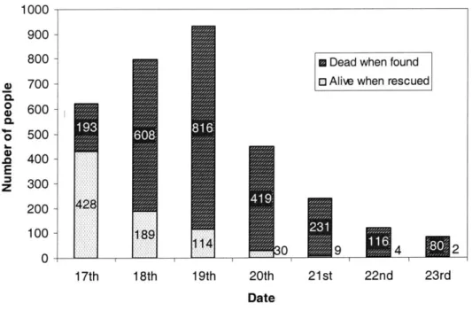
One aspect of a large-scale disaster relief mission is that activities such as searching and rescuing survivals, and repairing buildings temporarily to support rescue missions must be carried out in a short time period. Searching and rescuing survivals should be performed immediately after a disaster occurs. Figure 1.1 shows a relation between time and the number of people rescued after the Great Hanshin-Awaji (Kobe) Earthquake[4] [5] [6] that occurred on January 1 7th, 1995. The number of survivals decreased rapidly after the day the
earthquake hit.
The other aspect is that various kinds of teams and organizations take part in search and rescue activities. When Kobe Earthquake occurred, fire fighting rescue teams from other cities as well as from local cities, the police and the Self-Defense Forces were in charge of
consisted of 25 search and rescue (SAR) team members and 3 SAR dogs. The France government provided 60 SAR members and 4 SAR dogs. An NGO in the U.K. provided 15 SAR members and several kinds of SAR equipment. When a large earthquake occurred in Turkey on August 17t, 1999, forty-six countries provided assistance to Turkey according to the United Nations Development Programme (UNDP). Some of this assistance included 2,276 SAR team members, 224 SAR dogs, 23 ambulances, and 709 medical personnel. The U.S. Agency for International Development (USAID)/Office of U.S. Foreign Disaster Assistance (OFDA) deployed two SAR teams to help recover earthquake survivors.
1000 900 800 700 600 500 400 300 200 100 0
* Dead when found o Alive when rescued
19th 20th
Date
s9 n4 2
21 st 22nd 23rd
Figure 1.1: Number of people rescued/searched by SAR teams (Kobe Earthquake)
1.2 PROBLEMS
Two major problems arise: how to organize collaboration among participants; how to maintain information related to the disaster. Each participant has different issues and deals with different site-specific environments. Several participants need to collaborate with each other in terms of the same issue such as a particular building collapse, and form a group of personnel. When a large-scale disaster occurs, a large number of groups of participants with
a) 0. 4) 0. *d-E
Z
17th 18ththe particular topic exist simultaneously. Such groups may require the other participants or may synchronize with other groups. The collaborative platform should be designed to meet with the requirement addressed in a disaster relief mission.
To promote an effective disaster relief mission, information related to a disaster should be accurate and reliable, which means that information needs to be maintained in a consistent way so that every participant can access to the latest information. The system must keep track of information transaction in order to make the information be secure.
In a disaster area, two kinds of information are critical for decision-makings, resource allocation and site-specific information. The resource allocation consists of staff deployment and equipment allocation. The resource allocation changes frequently since it is difficult to estimate the need of the resources beforehand and actual site-specific information triggers the new deployment. Site-specific information is usually vague and becomes distinct gradually as the on-site activities progress.
Some of the devices and technologies have potential for facilitating a disaster relief mission. Since most of the critical information is related to field agents, a client device and tool for a field agent should be investigated and the interface between these devices and the whole system should be designed. This study proposes to introduce wireless devices and an autonomous robot. Wireless devices are suitable to establish connection between on-site personnel and the collaboration platform and an autonomous robot is adopted to collect information about disaster environment where personnel cannot enter.
1.3 OBJECTIVES
This study designs an emergency management system that consists of collaboration platform and data repositories. The system facilitates the collaboration between the participants and allows multiple device accesses so that they can share the information and make decisions efficiently. The collaboration platform furnishes a virtual conference room, and offers the privilege to organize a meeting and the methods of sharing the information. The data repositories keep tracks of resources related to a disaster relief mission so that these
resources can be re-allocated efficiently, and store site-specific information to be accessed by every participants.
A method of gathering site-specific information is developed by focusing on a robot that can drive itself around according to the instruction and can sense the nearby environment including the communication between a robots and a PC/handheld device.
1.4 APPROACH
In Chapter 2, general description about a disaster relief mission is provided. It involves several emergency management systems of government organizations and actual large-scale disaster relief missions.
Chapter 3 describes several existing solution of emergency management. The first part features the commercial software that governmental organizations adopted as their emergency management systems. The latter part explains about collaboration environment developed at MIT.
Chapter 4 introduces the feature of the collaborative system for disaster relief missions. First, target users and activities are defined by developing use cases of the system and then the architecture is designed using UML diagrams.
Chapter 5 focuses on client devices that allow users to access web-based resources and to participate in collaborative environments in different ways. Much attention is paid to portable/ handheld devices such as PDAs and Java-enable phones. Also this chapter
features wireless networks.
Chapter 6 introduces human-robot interaction in order to collect site-specific information primary addressing the issue of locating victims. The potential needs for robots and requirements of human-robot interaction are discussed.
2. DISASTER RELIEF MISSION
2.1 SEARCH AND RESCUE MISSION
This section describes an overview of a search and rescue (SAR) activities in the U.S. When a large-scale disaster occurs:
* Response always begins at the local level. Local fire departments, emergency management, and local and state law enforcement are the first arrive at the disaster area and begin SAR and response.
" Following the disaster the local emergency manager may request assistance from the state; if the need is great, the state may in turn requests federal assistance; in the event of a large-scale disaster, FEMA deploys three of the closest task forces.
* After arriving at the site, structural specialist, who are licensed professional engineers charged with making the rescue safe for the rescuers. They provide direct input to the SAR team members about structural integrity of the building and the risk of secondary collapses.
" Heavy equipment is used to remove large rubble and debris that could injure rescue workers and impede rescue operations.
* The search team ventures around and into the collapsed structure, carefully shoring up structures while attempting to locate trapped victims. Rescuers use electronic listening devices, extremely small search cameras and specially trained search dogs to help locate victims.
* Once a victim is located, the search group begins the daunting task of breaking and cutting through thousands of pounds of concrete, metal, and wood to reach the victims. They also stabilize and support the entry and work areas with wood shoring
to prevent further collapse.
" Throughout the effort hazardous materials specialists evaluate the disaster site, and decontaminate rescue and medical members who may be exposed to hazardous chemicals or decaying bodies.
* Heavy rigging specialists direct the use of heavy machinery, such as cranes and bulldozers. These specialists understand the special dangers of working in a collapsed structure, and help to ensure the safety of the victims and rescuers inside.
* Technical information and communication specialists ensure that all team members can communicate with each other and the task force leaders, facilitating search efforts and coordinating evacuation in the event of a secondary collapse.
" Logistics specialists handle the more than 16,000 pieces of equipment to support the search and extrication of the victims. The equipment cache includes such essentials as concrete cutting saws, search cameras, medical supplies, and tents, cots, food and water to keep the task force self-sufficient for up to four days.
2.2 LOCAL OPERATIONS: SAN FRANCISCO
The Mayor's Office of Emergency Service (MEOS)[2] is the component of the Mayor's staff with responsibility for strategic emergency planning. MEOS develops and manages the emergency plan for the City and Country of San Francisco, coordinates all protective and relief service, trains emergency service.
The Emergency Operation Center (EOC) is the central location for coordination of emergency response activities. EOC serves as the location where damage information is assessed, the over all disaster situation is analyzed, and the City's response and recovery priorities are established.
(ACS) serves as an alternate means of communications for the Office of Emergency Services.
2.3 LOCAL OPERATIONS: NEW YORK CITY
The Mayor's Office of Emergency Management (OEM)[3] is the On-Scene Coordinator at all emergency incidents and has the responsibility for interagency coordination and communication. When a disaster occurs, OEM activates the City's Emergency Operations Center, and administers the Urban Search and Rescue Team.
During an emergency, the Watch Command officers monitor all emergency services radio frequencies (Police, Fire, EMS), and have access to NYSPIN (New York State Police Information Network); NAWAS (The National Warning and Alert System, which offers information provided by the Federal Emergency Management Agency and the New York State Emergency Management Office); The National Weather Service; The Emergency Medical Service's Computer-Aided Dispatch, and the Con Edison Hotline. Monitoring events and developing situations city-wide, these officers keep the OEM staff informed, act as a response dispatch and communications link, and provide inter-agency notification services.
If an emergency requires a multi-agency response, OEM is the on-scene coordinator, working in conjunction with the Incident Commander (the highest ranking chief officer of either the police department or fire department). OEM will also set up a unified interagency command post, and provide support to the operation by streamlining the procurement of resources.
The Emergency Operation Center offers space and facilities where the related agencies can operate their tasks: they can interact with their home agency command centers; they can collaborate with the administrative staff of OEM.
2.4 FEDERAL OPERATIONS: FEMA
The Federal Emergency Management Agency (FEMA)[1] is an independent agency of the federal government, reporting to the President. The goal of FEMA is to reduce loss of
life and property and protect the nation's critical infrastructure from all types of hazards.
The National Urban Search and Rescue (JS&R) Response System, established under the authority of FEIA, is a framework for the structuring local emergency services personnel into integrate disaster response task forces. These task forces, complete with necessary tools and equipment, and required skills and techniques, can be deployed by FEMA for the rescue of victims of structural collapse.
Disaster may require resources beyond the capabilities of the local or State authorities. In response of regional requests for support, FEMA provides: mobile emergency response support; task forces comprised of SAR operation staff, equipment, and SAR dogs; incident support teams that supports task forces mission through logistical, electronic and coordination expertise.
In a disaster area, FEMA provides mobile telecommunications, logistics, and operational support to the Federal, State, and Local responders. The Response and Recovery Directorate's Mobile Operations Division (RR-MO) maintains mobile telecommunications, operational support, life support, and power generation assets for the on-site management of disaster relief activities.
There are 28 FEMA US&R Task Forces spread throughout the continental United States trained and equipped by FEMA to conduct round-the-clock SAR operations following disasters such as earthquakes, tornados, floods, hurricanes, aircraft accidents, hazardous materials spills and catastrophic structure collapses. Each task force consists of two 31-person teams, four canines, and a comprehensive equipment cache. Task Force members work in four areas of specialization: search, to find victims trapped after a disaster; rescue, which includes safely digging victims out of tons of collapsed concrete and metals; technical, made up of structural specialists who make rescues for the rescuers; and medical, which cares for the victims before and after a rescue. Emergency managers with special training in urban SAR environments conduct SAR activities.
The task force equipment cache must be a construction site, communication center, high-tech engineering firm, mobile emergency room, and camp rolled into one. The cache
consists of five types of equipment: medical, rescue, communications, technical support and logistics. The communication section allows rescuers to stay in contact in case of a find or an evacuation. Generators, lights, radios, cellular phones, laptop computers and other electronics equipment are used.
2.5 LARGE-SCALE DISASTER: KOBE EARTHQUAKE
The Great Hanshin-Awaji Earthquake[4] [5] [6] (also called Kobe Earthquake) of magnitude (M) 7.2 on January 17, 1995, jolted central western Japan and brought the most serious damage in the last 70 years. The earthquake hit the southern part of Hyogo Prefecture including the city of Kobe, Japan's sixth largest city with 1.5 million population, and the northern part of Osaka Prefecture. Death toll from the earthquake rose over five thousand, and about 100,000 houses and buildings were totally destroyed. It was really a big
shock to various societies in Japan.
2.5.1 Damage Description
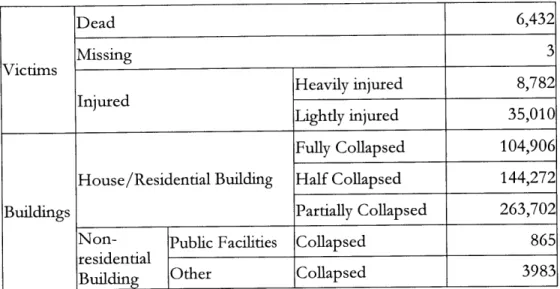
The earthquake brought serious damage of 6,432 dead people, 3 missing and 4,3792 injured. The victims and damage to buildings are summarized in Table 2.1. Not only strong shaking but also wide spread fires after the earthquake were the main cause of building damage and human casualties. Civil infrastructures were also severely affected: a large number of highway and railway bridges were collapsed; minor to severe damage occurred in 5 thermal power stations, 17 substations, 23 transmission lines, and several hundred distribution lines; gas supply was stopped for 860 thousand customers of Osaka Gas; raw water pipes from the river to filtration plants were broken in many places and some filtration plants were also damaged; structural damage to telecommunication systems was large, mostly
Table 2.1: Earthquake victims and damage to buildings (Kobe Earthquake) Dead 6,432 Victims Missing 3 Heavily injured 8,782 Lightly injured 35,010 Fully Collapsed 104,906
House/Residential Building Half Collapsed 144,272
Buildings Partially Collapsed 263,702
Non- Public Facilities Collapsed 865
residential
Building Other Collapsed 3983
2.5.2 SAR Activities
After the earthquake occurred at 5:46 in the morning of January 17, 1995, immediate responses in the heavily hit areas were concentrated to search and rescue, and fire fighting. Hyogo Police Department established disaster guard headquarters at 6:15 a.m., Hyogo Prefectural government and Kobe city independently established their emergency response offices at 7:00 a.m. National government decided to establish major emergency response headquarters during the cabinet meeting in the morning, and the first meeting of the headquarters held in the afternoon agreed to help municipal governments in the heavily affected area with respect to rescue operations and earliest possible recovery.
But information was scarce and resources were lacking in the affected area. The first personnel reported to the prefectural office at 6:45, an hour after the earthquake, and at 2:00 p.m., more than eight hours after the earthquake, only about 20 percent of the prefectural personnel could report to their head office. The request for help to the Japan Ground Self Defense Force (JGSDF) was made by the prefectural office at 10:00.
organization in Tokyo, for help. It is reported that during the day of the earthquake 1,180 personnel from 19 local governments reached Kobe with 243 vehicles. However, lack of water as well as extremely heavy traffic congestion hindered efficient firefighting operations. By the evening of the day, most small-scale fires were extinguished, but eleven big fires were still raging. These fires were mostly under control on the morning of January 18 after having burnt down about 54 hectares. The total burnt-down area is reported as about 66 hectares.
Search and rescue (SAR) was done by the people from the fire department, JGSDF, and the people from the police department. However, it seems that by far the majority of the people trapped under collapsed houses were rescued by family members and/or neighbors. An estimate tells that a total of about 20,000 people were buried under collapsed houses, of which about 15,000 were rescued by the ordinary people.
The JGSDF headquarters located in the peripheral area of the stricken region was ready to mobilize its troops at 6:00 a.m. They waited for the official request of the prefectural governor to come, which is generally required by law. It was 10:00 a.m., about four hours after the earthquake, that the governor of Hyogo prefecture officially requested help to
JGSDF.
However, because of the lack of information on the scale of assistance, the finaldecision to send a large troop to the stricken area was made at 3:00 a.m. on the early morning of January 18, and it was 6:00 p.m. of the same day, about one and half day after the occurrence of the earthquake, that a large troop of 9,000 reached the heavily stricken area.
It is believed that the mobilization of JGSDF was too late. Looking at the numbers of the people rescued by fire service people and JGSDF on January 17 and 18 (Table 2.2), it is inferred that, if JGSDF had been mobilized earlier, more people could have been rescued alive.
There are more than several reasons for the delay of the dispatch of JGSDF. The Self Defense Force Law is said to be inadequate in that a request of the prefectural governor is required before JGSDF troops be dispatched. It is also said that the relationship between the local government and the JGSDF in the area should have been better. Some also say that JGSDF itself had not been prepared for such a large-scale disaster and that they did
not have efficient rescue equipment during the immediate hours. However, the greatest problem seems to be the lack of information regarding the real status of the disaster. If it had been known that a disaster with 5,500 deaths was taking place, the responses of all organizations must have been different.
Table 2.2: Rescued people by Fire service and JGSDF (Kobe Earthquake)
17th 18th 19th 20th 21st 22nd 23rd 24th - Total Jan. 3rd Feb. FIRE SERVICE 396 123 70 18 6 4 2 0 619 AliveJGSDF 32 66 44 12 3 0 0 0 157 Total 428 189 114 30 9 4 2 0 776 FIRE SERVICE 137 320 385 185 146 86 14 20 1293 Dead
JGSDF
56 288 431 234 85 30 66 27 1217 Total 193 608 816 419 231 116 80 47 2510Dead and alive 621 797 930 449 240 120 82 47 3286
Survival rate 69% 24% 12%1 6.7%1 3.8% 3.3% 2.4% 0% 23.6%
2.6 LARGE-SCALE DISASTER: TURKEY EARTHQUAKE
An earthquake of M=7.8 hit Turkey on August 17, 1999 under the city of Izmit. An aftershock of M=5.8 followed on September 13. The second major earthquake of M=7.2 hit northwestern Turkey near the town of Duzce (located on the northern coast of Turkey, east of Istanbul) on November 12. The earthquakes wreaked havoc on the region, leaving thousands dead, and hundreds of thousands injured or homeless.
2.6.1 Damage Description
with additional thousands missing and presumed dead. Turkey's National Security Council estimated 200,000 people were made homeless.
The earthquake damaged buildings across seven provinces for a distance of 250 km from Istanbul to Bolu. As many as 70% of the buildings in portions of the cities of Adapazari, Golcuk, Izmit, Topcular, and Kular were severely damaged or collapsed (Coburn, Halling and Sezen, 1999). Nearly all the fatalities and injuries can be attributed to building collapse. As of September 6, 1999, the Government Crisis Center reported 20,957 buildings were heavily damaged or collapsed. Other reports suggest that up to 115,000 buildings were damaged beyond repair. Building losses are reported to amount to about US$5 billion.
After the November 12 earthquake, most of the damage was concentrated in Kaynasli a small town on the main highway between Duzce and Bolu. Loss of life in Duzce seemed to concentrate in few collapsed buildings that were "lightly" damaged in the August 17 earthquake, superficially repaired and later inhabited. Loss of life was somewhat limited since the buildings damaged in the August 17 earthquake were already vacated. Total number of heavily damaged buildings was in the vicinity of 200. 550 people lost their lives (as of November 17, 1999) and over 3000 people were hospitalized with injuries.
2.6.2 SAR Activities
After the August 17 earthquake, initial search and rescue (SAR) was strongly criticized as slow and unorganized. This appeared to be the result of loss of communications, lack of command and control, shortage of equipment and materials, and an absence of disaster response training. Much of the initial response was by survivors. International SAR teams began arriving within 24 hours, and 65 foreign SAR teams saved 621 lives in intensive efforts that continued for four or five days following the earthquake. Initially there was friction between SAR teams and heavy equipment operators attempting to aid in the search. SAR workers were concerned that additional injuries would be caused by heavy equipment, but later realized the enormity of the task and accepted the method. Not until three days after the event did 50,000 soldiers arrive to assist in SAR and debris clearance.
3. COLLABORATIVE ENVIRONMENT FOR EMERGENCY
MANAGEMENT
3.1 EIS/GEM INFOBOOK
Essential Technologies, Inc.[10] developed the EIS/GEM InfobookTM, which was adopted by FEMA as the emergency operating software component of the National Emergency Management Information System (NEMIS). Also, it is the software of choice for: Local and State Governments; US Armed Forces including Air Force, Army, Navy, National Guard, and Coast Guard; Chemical, pharmaceutical; utilities; and other companies.
EIS/GEM offers capabilities user can customize the functionalities and user interface of their system to match their organizational needs. It allows users to:
" Create and automate users' own data searches (similar to macros)
* Set up data entry buttons that automatically enter consistent information for users
* Launch third-party software
* Generate special reports
* Display messages and prompts on screen with one click
* Create a collection of searches that run unassisted for automatic briefings
* Search and display data automatically on a regular basis to show the current state-of-the-incident
" Organize just the tasks users use into a single convenient page or spot
EIS/GEM contains hundreds of vital and utilities all with open architecture and in line with industry standards. It is designed as the critical center of users' system-wide information
management, and is used to:
" Interface with additional mapping and GIS products * Display and interpret spatial output from predictive models
* Take advantage of multi-media enhancements of data
* Launch users' favorite spreadsheet and word processing packages, and Internet browsers
" Read real-time information from data gathering products such as meteorological stations
* Import data from all industry standard databases, saving time and money in data entry
EIS/GEM Infobook serves in almost any computing environment: stand-alone workstations; Local or Wide Area Network configurations; Client/Server architectures (with
Oracle or SQL Server); Internet/Intranet/Intra Webs. The system lets users share data, maps, images, and predictive model output between crisis responders in the field and the crisis management coordinator, between branch offices, or between different organizations. InfoComm, built-in message management system, provides users with fast, flexible, reliable connectivity, and serves as the origin and destination for all of users' messaging needs. Basically it distributes messages, taskings, and other data throughout users' LAN with its built-in Message Center. It has capability to extend communication using Internet/Intranet: it can send message to and receive them from external E-mails systems that are MAPI-compliant programs. In addition, InfoComm can integrate EIS/GEM's own ECOMM point-to-point communications program, providing robust connectivity via telephone, cellular, and wireless modems as well as satellite and packet radio.
EIS/GEM improves performance in staff and equipment resource management. It automatically records the action system-wide, noting the deployment in the resource or personnel records by updating available quantities and status. In addition, it enters the
deployment into Operations Log so that users always know where everyone and everything is at any moment. To locate staff and/or equipment, EIS/GEM provides mapping system that is fully integrated with its own multi-level raster maps plus several third-party mapping systems such as ArcView@, MapInfo@, and DeLorme Street Atlas USATM.
EIS/GEM can be integrated with third-party predictive models related to chemicals, waste products, oil or radiation. To predict the impact of various kinds of releases, it is also
combined with the latest in sensor technology.
Figure 3.2: EIS/GEM resource inventory [10]
3.2 RESPONSE INFORMATION MANAGEMENT SYSTEM (RIMS)
California's Response Information Management System (RIMS) [11] is a statewide system used to coordinate and manage a State's response to disasters and emergencies. It is a collaborative, web-based system that links the multiple levels of emergency management within the state and automates the state's emergency management system.
The application was developed jointly by the California Office of Emergency Services (OES) and a CSMC[12] project team and has been fielded at over 500 locations with over 2500 active users. RIMS includes several applications including resource management, intelligence reporting, cost accounting and a purchasing system. It has a GIS component to display interactive maps and photos during a disaster.
RIMS is available to all cities, special districts and state agencies within California that have a computer with access to the Internet. Web access to RIMS is controlled by user IDs and passwords. Web browser clients and Internet access are standard and supported in
nearly every government agency, and those agencies that do not have access now soon will. RIMS user base has expanded from 137 agencies to 2500 by developing the internet-based system.
The RIMS applications have been converted to Web accessible format and new, more powerful Lotus Domino Web servers have been installed at each of
OES'
Regional Emergency Operations Centers. In addition, high-speed Internet access has been added at each OES Region to handle the increased RIMS user traffic.Clients will still be able to dial in directly to their OES Region using regular phone lines or the Operational Area Satellite Information System (OASIS) (only Operational Areas (OAs) for backup access). Instead of dialing directly into a Lotus Notes server, users will dial into OES just like accessing an Internet Provider. Clients will be able to simultaneously access both RIMS and other OES Lotus Notes applications if they have a notes client. Even though they will be using Web browsers directly to OES for RIMS, they will not be able to get beyond RIMS with their Web browsers.
Ajdrass _]1 tp//Vnmn ranid osa, C 3Q:,Go o Links
Response
Information
RIS
Management
System
RIMS AccessTechnical Support, & Latest RIMS
Lost Password Enhancements Requests
California's Response Information Management System
SEWS
(RIMS) is a statewide computer system wed to Standardizedcoordinate and manage the State's response te disasters E"nergeicy
and emergencies. Sysiem It has been fielded at ever 500 locations statewide and is -f expected to reach sver 2500 using abrowser client
MRKT
Mission Request
... Tasking
RIMS Holp
3.3 E TEAM
E Team[13] is an Internet-based workflow management application designed for emergency and event personnel. It allows Web-connected users to enter and access standardized reports, requests, and directives; view and edit annotated maps; and access common databases in order to manage an event or disaster. It is a fully Web-enabled, ODBC and CORBA compliant application, based on Lotus DominoTM web server software, ESRI-based map utilities accommodate vector and raster data.
The solution is comprised of Windows NT servers loaded Lotus Domino, E Team software and users equipped with Internet browser such as Internet Explorer and Netscape. The system enables users to share the disaster-related information such as the status of an incident, where the personnel is deployed, and the location and the availability of resources. Users can enter the information into a set of pre-defined forms, and the information can be cross-referenced to a map of underlying database. IT managers can set policy on which users can access what data.
Bellow is a list of key features and benefits of E Team product.
* ICS compliant: E Team software supports emergency teams using the Incident Command System at all levels of command. Every participant at all command posts and operations centers has access to whatever view of the overall status that they need and are authorized to see.
* Data sharing: E Team allows every user to post and retrieve information to a commonly accessible repository.
* Maps and overlays: Locations of key incidents and facilities are available on map overlays. Clicking on icons navigates users to the source report or data.
attention. Clicking summary rows brings up the details.
* Security and auditability: Users can be given different levels of access. All transactions are captured and stored automatically.
Functions of E Team support several kinds of information that are vital to emergency management.
" Incident reporting: All ICS-specified information can be quickly filled in on intuitive forms.
* Rescue request tracking: Summary displays are accessible to every user and show the status of requests and who needs to take action.
* Infrastructure status reporting: Simple reports indicate who needs help and who can help. Public facilities managers can easily report and view summary or detail, operational capability, damage and assistance required. Current status of hospitals, medical facilities and shelters can be seen in summary, in detail and on the map. Web-ready release of public information can be quickly prepared, routed through an edit and approval chain, and posted to the Internet.
These are the upcoming enhancements to be implemented to E Team.
* Mobile clients on laptops and Palm PCs connected by cell phone, wireless WAN or radio
* Mark-up map overlays
* Messaging and work group organization tools
vW STATUS TW tMAP 4mMEB - TWFisE IPXti MW Incidents Oy Stalus
CAy Iit test ftetbh Los Argtpg POe 070Ai19" V t4
tvwtsMAxplen Crash Los Arqwes Fme O7 39 V
P osdn COOM Hvymay Mud $bI* MHlbu P'ik tvoutseermi" 07WSi190 a Oe r I
w Cmd y uerbance Los Arggp*m Nat repO-ed
M05 V OMNSAA Copse AN
AdE_ E 21 PM
Figure 3.4: E Team Internet-based Emergency Management Software [13]
C 9 9, E.Tean, lqn
Zoom in Mede
Fguei 3.5: Infomaion cWo u As MseoT
Figure 3.5: Information cross-referenced to a map
(E
Team) [13]WVAWOMIWg VA: WW_ MvW_*lv qV Sum O7MM3 999 ot 09:57 GMAM ! , Uri"
3.4 LOTUS SOLUTIONS
As mentioned above, California Office of Emergency Services (OES) utilizes Lotus Notes applications, and E Team's solution is based on Lotus Domino. Lotus Notes and Domino are mainly the client/server combination for collaborative environments including Internet messaging and directories, group scheduling, and discussion. Figure 3.6 shows the key Notes and Domino hardware and software components. The hardware components are Notes client computers, Domino server computers, and the network that connects them. The software components reside on the client and server computers. The same three-level software architecture is used on both client and server computers, and each key software component belongs to one of the levels:
" Client and server programs
* Notes Object Services (NOS)
" Databases and files
Lotus Domino servers and Lotus Notes clients together provide an electronic messaging system that is reliable and flexible enough to meet the evolving needs of the collaborative environments. Domino and Notes messaging system supports not only traditional e-mail that relies solely on point-to-point, point-to-multi-point communication based on sending messages from one person to another, but also group discussion that lets groups of users work together on a single instance of a document, or interact with each other on a range of topics. Lotus defines two messaging paradigms: one is many-to-one that denotes many users collaborate on a single topic, and is supported in a Domino Document Library; the other is many-to-many that denotes many users collaborate on a range of related topics and is
supported in a Domino Discussion.
A Domino discussion database serves as a meeting place where a workgroup can share ideas conveniently and securely. A Notes client automatically lets discussion participants
trace the sequence of replies in a discussion, using collapsible sections to speed navigations and without the need to wade through irrelevant documents. Documents can be categorized by topic, with views available by category, author or date.
Domino and Notes calendaring/scheduling features provide group scheduling, time management and task management. These features also support development of organizational calendaring applications, such as workforce time management. Customers and Lotus Business Partners can utilize Domino and Organizer APIs, Visual Basic, LotusScript, ODBC, OLE 2.0 and a variety of other methods to access data and automate processes. The Domino data store holds both mail and calendar information. Notes users can benefit from real-time access to free/busy time information. Domino and Notes infrastructure serves as the delivery vehicle for meeting notices and replies, while Domino replication ensures a robust, scalable solution for the mobile or occasionally connected users as well.
Domino provides users with ability to manage document-based workflow. Domino greatly simplifies document management process like:
" Pouting documents for review and publication
* Tracking the status of routed documents
* Enterprise and inter-enterprise document distribution
" Providing robust, flexible security for documents and/or components of documents down to the field level
* Making documents accessible either widely or selectively
* Organizing and linking documents
* Document maintenance and archiving
With Domino and Notes Messaging's full text search and query capabilities, along with the Notes clients' customizable views and hierarchical folders, users do not have to remember
file names, authors or dates to retrieve information.
Lotus Domino and Notes messaging system provides users with a variety of collaborative services. These services are not equipped with synchronous features: group discussion allows many users to post messages, but a meeting place is not so organized. A group discussion service is no more than a traditional Bulletin Board System furnished with more security features.
Notes Clients
Y YL
Domirn Servers network Client/Server level -NOS level -Database/File level --networkFigure 3.6: Lotus Notes and Domino components [14]
3.4.1 Lotus Domino
Domino's integrated application services optimize the platform for rapid delivery of the collaborative Web applications. Built-in connection services provide live access to leading relational databases, transaction systems and ERP applications. Also users can use leading third party Web development tools along with Domino's integrated development environment.
messaging standards, with Internet addressing, SMTP routing and MIME content support all native. Plus full support for E/SMTP, S/MIME, SSL, POP3, IMAP4, LDAP, HTTP, HTML, SNMP and all the rest. Domino delivers the utmost in interoperability with users' current tools and systems.
Domino runs on several platforms, including Windows NT, OS/2, UNIX, AS/400, Linux and S/390. And Domino supports a wide variety of clients, in addition to the Notes client. Messaging features are available to Web browsers and Internet mail clients (such as POP3 and IMAPv4 clients); directory features are available to browsers and LDAP clients; discussion features are available to browsers and NNTP newsreader clients; and administration features are available to browsers as well as the Notes client. In addition, Domino offers the platform for designing dynamic Web applications, and with the Domino Designer, users can easily build a single application that looks and runs the same for both the Web and Notes.
3.4.2 Lotus Notes
Lotus Notes is an integrated e-mail and collaborative application software for the Internet and corporate intranets. An intuitive, Web-inspired environment, Notes integrates users information sources, including e-mail, calendaring, group scheduling, and to do list. Notes users can exchange messages via the Internet, work with any Web application, read and post topics to Internet newsgroups, search Web directories, and use X.509 certificates for security. Notes lets users access their e-mail and other applications while they are off-line and gives them the option to synchronize their work later.
Tight integration with the Lotus Domino Server makes Notes the most powerful e-business client available, delivering unmatched functionality, security and customization options. Notes enables organizations to maximize the value of their Domino infrastructure -from standards-based messaging to built-in collaborative applications like discussions and document
libraries,
to the unlimited potential of Domino-based collaborative environment solutions. Together, Notes and Domino enable organizations to lower the total cost of a messaging and collaboration infrastructure, while enhancing users' productivity and reducingadministrative overhead.
3.4.2 Mobile Access to Lotus Services
Mobile Notes, via the Mobile Services for Domino server, provides secure anytime, anywhere interactive access to Notes Mail, calendar and directory services from Web-enabled devices including cell phones, pagers and PDAs.
Together, Mobile Notes and Mobile Services for Domino (MSD) offer organizations:
* Robust security: Lotus Notes and Domino represent one of the most secure data networking environments available. MSD builds on these proven capabilities, in combination with new technologies and industry standards like SSL, to address the unique challenges presented by wireless data access. MSD enables organizations to associate an authorized user with each mobile device, track what network a device is used on, encrypt data in transmission, and more.
* Centralized control: MSD provides a full complement of wireless administrative capabilities, which are integrated with the Domino Administrator. So you can easily manage all your organization's wireless users and devices. Familiar Domino security features give you total control over who gets into your network, and what gets out
over it.
* Extranet access: MSD includes a Domino-based Web site that customers and colleagues-inside or outside your organization-can use to contact mobile users via e-mail. The site is easy for administrators to configure and for visitors to use, ensuring both privacy and convenience.
* Extended reach for applications: Rapidly create or extend Domino applications, via standard Domino APIs, to automatically send e-mail to mobile phone users in response to events. MSD also enables you to send alerts and notifications to users of one- and two-way pagers and PDAs, via Domino applications.
3.4.2.1 Mobile Services for Domino
Mobile Services for Domino is a server that acts as a proxy, facilitates secure communications, and delivers Domino's leading messaging and collaborative applications to Mobile Notes - the access point that provides users with a Notes-experience from Web-enabled devices including cellular phones, pagers and PDAs. Mobile Services for Domino also provides push technology to deliver paging and short messaging services.
Features new to Mobile Services for Domino server include:
" Unified installation: allows organizations to easily setup Wireless Domino Access and/or Messaging Services using a single installation program.
* Centralized administration: provides centralized administration to configure the server, devices, security, and users. And to record events and manage all the wireless services.
* Messaging service enhancements: have been expanded to include support for EMI/UCP, X.25 and SMS in Europe. Users will also see improved reliability using Service Based Query, and a greatly enhanced console user interface.
* Expanded international support: allows characters sets like UTF-8, Shift-JIS and Korean to be recognized and translated. And international dialing is supported.
* Enhanced stability and performance. Provides Notes and Domino customers with dependable wireless messaging within their enterprises but outside their trusted firewall.
* Stronger security: allows for longer Domino passwords, more stringent security on database access, and end-to-end session logging for easier management and auditing.
* Extended support: provides additional protocol, device support and wireless data network support.
3.4.2.2 Mobile Notes
Lotus Mobile Notes extends the value of Lotus Notes and Domino by providing secure, real-time access to users' e-mail, calendar and directory information from Web-enabled mobile phones. With Mobile Notes users can send and receive Notes mail messages, view users' calendar and schedule appointments from any location. Integration with the corporate Domino directory lets users search for names, address e-mail messages and dial the phone automatically.
3.5 COLLABORATIVE ENVIRONMENT AT MIT
The DaVinci Initiative[15] investigates the use of information technologies to improve online collaborations. The focus of the research at MIT has been in the area of meetings, both online and physical, and how the participants interact, leading to some general observations of collaborations and their participants. Of these observations, the protocols and rules used during a meeting have been the primary focus of research at MIT. Meeting protocols establish how information is shared within the collaboration and how control of the meeting is established.
CAIRO (Collaborative Agent Interaction and SynchROnization)[16] was developed as a realization of the collaboration research at MIT. CAIRO is a meeting environment that encompasses many of the research results such as membership and meeting protocol enforcement. Using a strong implementation of meeting protocols, CAIRO uses the Internet to communicate in a highly structured environment that includes protocol-enforcing agents to simulate a physical meeting with a facilitator.
3.5.1 Meeting structure
Within the CAIRO meeting environment, there is a strong sense of membership in a team. In addition to the long-term regular participants, there are transient participants, who are involved for a subset of the entire project. These transient participants include people such as guest speakers or experts. Communication between any participant (regular or transient members) takes place via conversations between all participants or a subset of the participants. Conversations that do not involve all of the meeting participants are
termed whispers, modeled after the act of whispering in a physical meeting. As the size of the meeting grows and the number of issues to be resolved privately increases, breakout meetings are formed to further discuss and resolve key issues among a subset of the team. Breakout meetings are formed to discuss and resolve specific issues, and generally involve a subset of the parent meeting participants. As finer grain detail is expected, outside participants may be asked to join the breakout meeting based on their area of expertise. Opening up meetings to outside participants, such as expert consultants increases the potential for proprietary or private information to be accessed by unauthorized users. Similar to those in the CAIRO system, policies are in place to limit the flow of information between breakout meetings and parent meetings to ensure a consistent level of security between all meetings that are associated with each other. For example, a breakout mission-planning meeting may need access to equipment information, outside participants may join for consultation on equipment but these transient members should not have access to personnel information for the mission being discussed in the parent meeting.
3.5.2 Information Policies
When participants are utilizing many conversations in a single meeting, the collaboration system manages the knowledge and resource transfer within and between them. For instance, when a mission planner is required to communicate privately with a paramedic, the system could enable only the two conversing to access information generated and shared during their interaction, ensuring privacy between the two. The meeting environment is also responsible for making information generated in the primary conversation, such as agendas, drawings, and text-chat dialogs, accessible from the private communications. When a participant enters a breakout meeting, certain aspects of the main meeting data will move with them, and some will remain private to the parent meeting. Due to security issues such as information confidentiality, information policies are established for each meeting based on a set of meeting protocols, or simple rules of conduct.
3.5.3 Meeting Protocols
established protocols. For instance, consider a protocol, requiring all participants must ask permission to speak. If a participant chooses to speak without permission they will be breaking the protocols and hence slow the progression of the meeting and potentially divert the direction of the meeting. Protocols usually exist very loosely within a meeting environment because the enforcement of such protocols is left to the meeting participants themselves. When a system, like CAIRO, is deployed, support of the protocols is handled by the application acting as a neutral third party. Protocols make meetings more efficient by acting as enablers, requiring tokens for speech, monitoring speech time and supporting preset agendas, allowing members to keep the meeting on track.
System agent to Pic Name monitor meeting
u , L J and make suggestions
for meeting style and
agenda schedule
4tji
1
among other meetingprotocols Speech Request Manage multiple meetings from a single application Participants
Figure 3.7: CAIRO Meeting Environment [16]
3.6 COLLABORATIVE ENVIRONMENT AT DRAPER
Prior to the partnership with MIT, Draper Laboratory[17] pursued online collaboration by focusing on mission-planning applications. The target deployment at Draper is a military environment that is usually highly unstable and often involves human life. For these reasons, the focus of the research at Draper has led to some unique requirements including persistence of planning data between connections and the ability for agents in the field to
participate in the planning efforts.
3.6.1 Mission Planning Applications
Two of Draper's mission-planning applications were developed to support the needs of modern mission planners, replacing traditional paper-based solutions. They are the Geospatial Application that concentrates on geographical information, such as mapping of regions and routes between these regions and the Temporal Synchronization Application that deals with time constraint issues, such as mode of transportation and travel time. Together these two applications greatly improve the efficiency of the mission planning setting, breaking it into specialized tasks. Both applications were developed independent of any collaboration environment and independent of each other, however both developments used a similar architecture.
3.6.2 Draper Application Architecture and Data Persistence
Collaborative environments typically use applications centered on communication between participants. Once non-communication applications are introduced into this environment, persistence is needed to preserve the application data between sessions. These applications center on data: coordinates of a GIS application or time and actions information of a project management application. Consider a military collaboration environment, among geographically distributed participants using an unreliably network for communication. The persistence of the collaboration data would allow participants to rebuild their session from information stored on the repository rather than lose all access to information generated prior to their connection. To solve both collaboration and repository issues, Draper chose an object oriented database solution, which allowed several instances of an application to attach to the database and, thus, collaboratively work on the same information. Client applications attached to the database and submitted changes to that database. When a change was made on the database, all registered applications were notified of the change. Each instance of the application then displayed the change, resulting in synchronous collaboration. However, performance problems and development difficulties were encountered with this prototype. The speed and reliability of transactions are critical to
![Figure 3.1: EIS/GEM Infobook [10]](https://thumb-eu.123doks.com/thumbv2/123doknet/14363466.503074/25.918.261.667.356.685/figure-eis-gem-infobook.webp)
![Figure 3.2: EIS/GEM resource inventory [10]](https://thumb-eu.123doks.com/thumbv2/123doknet/14363466.503074/26.918.220.687.104.465/figure-eis-gem-resource-inventory.webp)
![Figure 3.3: California's Response Information Management System [11]](https://thumb-eu.123doks.com/thumbv2/123doknet/14363466.503074/27.918.160.745.589.977/figure-california-s-response-information-management.webp)
![Figure 3.4: E Team Internet-based Emergency Management Software [13]](https://thumb-eu.123doks.com/thumbv2/123doknet/14363466.503074/30.918.208.697.99.470/figure-e-team-internet-based-emergency-management-software.webp)
![Figure 3.6: Lotus Notes and Domino components [14]](https://thumb-eu.123doks.com/thumbv2/123doknet/14363466.503074/33.918.176.715.334.739/figure-lotus-notes-and-domino-components.webp)
![Figure 3.7: CAIRO Meeting Environment [16]](https://thumb-eu.123doks.com/thumbv2/123doknet/14363466.503074/39.918.268.635.403.715/figure-cairo-meeting-environment.webp)
![Figure 3.8: Geospatial Application [17]](https://thumb-eu.123doks.com/thumbv2/123doknet/14363466.503074/41.918.261.642.563.825/figure-geospatial-application.webp)
![Figure 3.9: Temporal Synchronization Application [17]](https://thumb-eu.123doks.com/thumbv2/123doknet/14363466.503074/42.918.258.646.104.377/figure-temporal-synchronization-application.webp)
