HAL Id: hal-03102456
https://hal.archives-ouvertes.fr/hal-03102456
Submitted on 8 Jan 2021
HAL is a multi-disciplinary open access
archive for the deposit and dissemination of
sci-entific research documents, whether they are
pub-lished or not. The documents may come from
teaching and research institutions in France or
abroad, or from public or private research centers.
L’archive ouverte pluridisciplinaire HAL, est
destinée au dépôt et à la diffusion de documents
scientifiques de niveau recherche, publiés ou non,
émanant des établissements d’enseignement et de
recherche français ou étrangers, des laboratoires
publics ou privés.
(Turkey)
Théa Ragon, Mark Simons, Quentin Bletery, Olivier Cavalié, Eric Fielding
To cite this version:
Théa Ragon, Mark Simons, Quentin Bletery, Olivier Cavalié, Eric Fielding. A stochastic view of the
2020 Elazığ Mw6.8 earthquake (Turkey). Geophysical Research Letters, American Geophysical Union,
2021, 48 (3), pp.e2020GL090704. �10.1029/2020GL090704�. �hal-03102456�
A stochastic view of the 2020 Elazı˘
g M
w6.8 earthquake
1
(Turkey)
2
Th´ea Ragon1, Mark Simons1, Quentin Bletery2, Olivier Cavali´e2, Eric
3
Fielding3
4
1Seismological Laboratory, California Institute of Technology, Pasadena, CA, USA.
5
2Universit´e Cˆote dAzur, IRD, CNRS, Observatoire de la Cˆote dAzur, G´eoazur, France.
6
3Jet Propulsion Laboratory, California Institute of Technology, Pasadena, CA, USA.
7
Key Points:
8
• We infer a stochastic model for the distribution of subsurface fault slip associated 9
with the 2020 Elazı˘g earthquake
10
• We account for uncertainties in both the depth-dependence of the assumed elas-11
tic structure and the location and geometry of the fault
12
• Our models are characterized by two primary patches of fault slip where distri-13
bution appears to be controlled by geometrical complexities
14
Corresponding author: Th´ea Ragon, tragon@caltech.edu
–1–
Accepted
Article
This article has been accepted for publication and undergone full peer review but has not been through the copyediting, typesetting, pagination and proofreading process, which may lead to differences between this version and the Version of Record. Please cite this article as doi: 10.1029/2020GL090704.
Accepted
Article
Abstract
15
Until the Mw 6.8 Elazı˘g earthquake ruptured the central portion of the East Anatolian
16
Fault (EAF, Turkey) on January 24, 2020, the region had only experienced moderate
mag-17
nitude (Mw< 6.2) earthquakes over the last century. We use geodetic data to constrain
18
a model of subsurface fault slip. We adopt an unregularized Bayesian sampling approach
19
relying solely on physically justifiable prior information and account for uncertainties in
20
both the assumed elastic structure and fault geometry. The rupture of the Elazı˘g
earth-21
quake was mostly unilateral, with two primary disconnected regions of slip. This
rup-22
ture pattern may be controlled by structural complexity. Both the Elazı˘g and 2010 Mw
23
6.1 Kovancılar events ruptured portions of the central EAF that are believed to be
cou-24
pled during interseismic periods, and the Palu segment is the last portion of the EAF
25
showing a large fault slip deficit which has not yet ruptured in the last 145 years.
26
Plain Language Summary
27
The Elazı˘g earthquake ruptured the central portion of the East Anatolian Fault
28
(EAF), a major strike-slip fault in eastern Turkey, on January 24, 2020. Before this event,
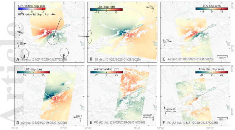
29
the region had only experienced moderate magnitude earthquakes over the last century.
30
We aim at understanding the rupture of this earthquake, and how it relates to the
his-31
torical ruptures of the EAF. To do so, we use measurements of displacement at the
sur-32
face to image the subsurface slip on the fault that occurred during the earthquake. As
33
the characteristics of the crust are poorly known, we make realistic assumptions on the
34
fault geometry and Earth structure, and build on novel approaches to account for the
35
possible biases of our assumptions and to characterize the uncertainties of the imaged
36
slip. We suggest that the Elazı˘g earthquake rupture may be controlled by structural
com-37
plexity of the fault, and that two main regions of slip surround a fault bend acting as
38
a barrier to rupture propagation. We also suggest that the fault segment located between
39
Lake Hazar and the city of Palu is the last portion of the central EAF, showing a large
40
deficit of the fault slip, which has not yet ruptured in the last 145 years.
41
1 Introduction
42
A large portion of Turkey is located on the Anatolian Plate (AP), which is slowly
43
extruding westward as a result of the north-south collision between the Arabian and Eurasian
44
tectonic plates (e.g., Mckenzie, 1970; McKenzie, 1972; McClusky et al., 2000). The
Accepted
Article
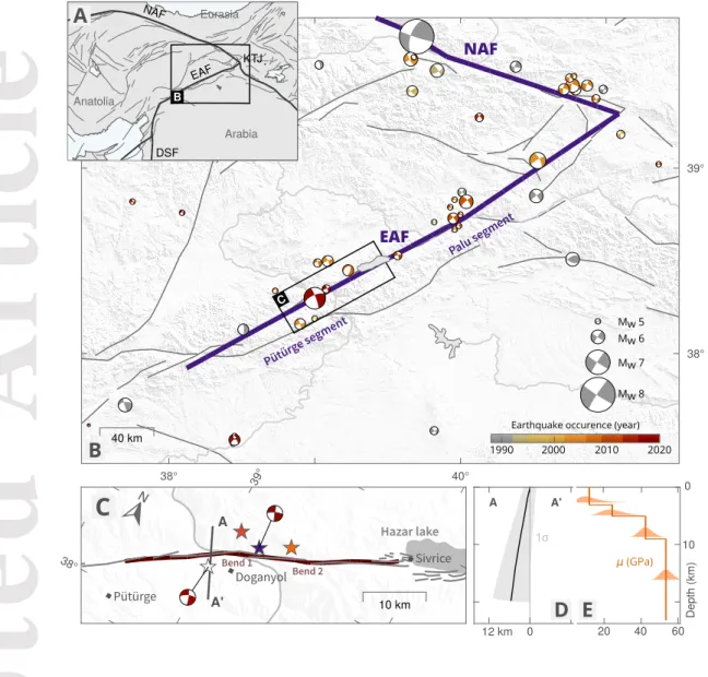
Figure 1. Tectonic setting and assumed characteristics for the Elazı˘g earthquake. (a)
Tec-tonic setting of the area, plate boundaries are shown in thick black lines. East and North Ana-tolian Faults are labelled (EAF and NAF), as well as the Dead Sea fault (DSF) and Karlıova Triple Junction (KTJ). (b) Active fault traces (Basilic et al., 2013) and seismicity since 1976
(GCMT, Dziewonski et al., 1981) around the EAF and NAF. The Elazı˘g earthquake focal
mech-anism (GCMT) is in red. (c) Details of assumed (dark red) a.nd mapped (gray) fault trace at the surface. Two structural bends of the causative fault geometry are highlighted. Possible epicenters are shown with white, red, purple and orange stars (from left to right on the map), respectively from GCMT, Jamalreyhani et al. (2020), KOERI and AFAD (2020). (d) Assumed fault geometry
at depth and associated uncertainty (standard deviation of 5◦around the assumed dip and 1
km around the fault surface trace). (e) Assumed shear moduli with depth (derived from Maden, 2012; Ozer et al., 2019) and associated uncertainties.
Accepted
Article
ward motion of the AP is predominantly accommodated along the North and East
Ana-46
tolian faults (NAF and EAF, Fig. 1). The NAF experienced a sequence of destructive
47
earthquakes that struck within the last eighty years (e.g., A. Barka, 1996; Stein et al.,
48
1997; Armijo et al., 1999; S¸eng¨or et al., 2005). In contrast, the EAF is generally assumed
49
to be less active, and has only experienced small to moderate events over the last
cen-50
tury, although large (M > 7) earthquakes have occured in the historical record (e.g.,
Am-51
braseys, 1970; Ambraseys & Jackson, 1998; Hubert-Ferrari et al., 2020).
52
The EAF is a left-lateral 600-km-long strike-slip fault linking the Dead Sea fault
53
(DSF, Fig. 1) to the Karlıova Triple Junction (KTJ, Fig. 1) where it intersects with the
54
right-lateral NAF (e.g., Yilmaz et al., 2006; Duman & Emre, 2013). The EAF has a
com-55
plex geometry divided into several main segments, each of them characterized by bends,
56
pull-apart basins or compressional structures (e.g., Duman & Emre, 2013), and also
com-57
prises multiple secondary sub-parallel and seismically active structures delineating a
50-58
km-wide fault zone (e.g., Bulut et al., 2012). The EAF accomodates a displacement of
59
9 to 15 mm/yr (Cetin et al., 2003; Reilinger et al., 2006; Cavali´e & J´onsson, 2014;
Ak-60
tug et al., 2016; Bletery et al., 2020), with creep dominantly at depths greater than 5
61
km (Cavali´e & J´onsson, 2014; Bletery et al., 2020). As a comparison, the NAF shows
62
creep rates around 20-25 mm/yr below a locking depth of 7-25 km (e.g. Cakir et al., 2014a;
63
Hussain et al., 2018; Kaneko et al., 2013; Walters et al., 2011; Wright et al., 2001).
Shal-64
lower portions of the EAF are characterized by an highly varying inter-seismic slip deficit,
65
some portions being fully coupled while others appear to be at least partially creeping
66
(Bletery et al., 2020).
67
The January 24 2020 Mw 6.8 earthquake ruptured the EAF between the Hazar
Pull-68
apart Basin and the city of P¨ut¨urge (Fig. 1). In the area, the main fault has been mapped,
69
from the interpretation of aerial photos and field studies, as a sinuous trend interrupted
70
by bends and step-overs whose widths do not exceed a kilometer (Duman & Emre, 2013).
71
Coseismic surface rupture does not show a significant horizontal component and is
prob-72
ably mostly gravitational (Tatar et al., 2020). In this study, we investigate the
subsur-73
face rupture of the Elazı˘g earthquake and its relationship to fault geometry and
inter-74
seismic slip deficit. While assuming a fault structure with a realistic geometry, we also
75
account for its inherent uncertainties, as well as uncertainties related to assumptions on
76
the crustal structure. We adopt a Bayesian sampling approach which allows us to
sam-77
ple a large panel of possible slip models and to estimate the posterior uncertainty on the
Accepted
Article
Figure 2. Observations used in thus study. (a) Surface displacement in the satelliteline-of-sight (LOS) direction from a Sentinel-1 (S1) ascending (asc.) interferogram, overlayed with coseismic GNSS offsets (Melgar et al., 2020). (b) Surface displacement from a Sentinel-1 de-scending (dsc.), (c) an ALOS-2 (A2) ade-scending interferogram, and (d) an ALOS-2 dede-scending interferogram. (e) Pixel-offset (PO) surface displacement in the satellite along-track (azimuth) di-rection from the ALOS-2 descending pair, and (f) from the ALOS-2 ascending pair. The surface projection of the satellite LOS direction is positive in the ground-to-satellite direction.
inverted slip distribution. This approach allows us to describe the rupture of the Elazı˘g
79
in detail, while discussing how it may have been driven by structural complexity. Finally,
80
we also provide an updated intepretation of the seismic budget for the central EAF.
81
2 Bayesian Inference framework
82
2.1 Data
83
We derive the earthquake surface displacement from four Synthetic Aperture Radar
84
(SAR) interferometric pairs and two SAR pixel offsets images (summarized in Table S2,
85
Figs 2 and S1 for a closer view on the deformation). We computed two ALOS-2
ascend-86
ing and descending interferograms, and two Sentinel-1 ascending and descending
Accepted
Article
ferograms. Copernicus Sentinel-1 data have been acquired by the European Space Agency
88
(ESA) and processed with the NSBAS software (Doin et al., 2012). ALOS-2 data are
89
collected by the Japan Aerospace Exploration Agency (JAXA) and have been processed
90
using the InSAR Scientific Computing Environment (ISCE) software (Rosen, 2012)
aug-91
mented with an additional module for processing ALOS-2 data (Liang & Fielding, 2017a).
92
We also applied pixel offset tracking analysis to ALOS-2 images on both tracks (Liang
93
& Fielding, 2017b). Resulting surface displacements have lower precision and higher noise
94
than LOS measurements, but provide useful information on the deformation along the
95
satellite track (azimuthal) direction. Due to snowy conditions in January, both L-band
96
ALOS-2 and C-band Sentinel-1 data decorrelate at higher topographic elevations. Note
97
that surface displacements derived from the InSAR data contain from 3 to 7 days of
post-98
seismic deformation, which might affect our modeling of the coseismic phase (Ragon, Sladen,
99
Bletery, et al., 2019; Twardzik et al., 2019). InSAR and dense pixel offsets from the
ALOS-100
2 descending track cover 1 year of preseismic and 1 month of postseismic deformation,
101
and thus also include long-term deformation. To improve computational efficiency, we
102
resample InSAR observations based on model resolution (Lohman & Simons, 2005) with
103
quadtree regions ranging from 12 km to 1.2-2 km wide. We remove data points that are
104
within 500 m of the fault trace to prevent spatial aliasing. We estimate measurement
105
uncertainties following Jolivet et al. (2012, Fig. S2). We also use 3 components
coseis-106
mic GNSS offsets at 6 stations located within 120 km of the rupture (Fig. 2). These
off-107
sets have been processed by Melgar et al. (2020) and extracted from high-rate GNSS
dis-108
placements.
109
2.2 Fault geometry and elastic structure
110
Duman and Emre (2013) mapped the main surface trace of the P¨ut¨urge segment
111
as a relatively continuous sinusoidal trend interrupted by small bends and step-overs whose
112
width do not exceed the kilometer. Over the Lake Hazar releasing bend (Fig. 1c), the
113
fault trace divides into multiple parallel lineaments that outline a 10 km wide fault zone
114
(e.g., Garcia Moreno et al., 2011). Around Do˘gyanol, the fault strike abruptly changes
115
by 10◦. West of the rupture area, two major bends affect the P¨ut¨urge segment before
116
it links to the Erkenek segment. The strike change around Do˘gyanol has been well
out-117
lined by InSAR data as well (Figs 2, S1), although the rupture did not reach the
sur-118
face. We build on these observations, as well as on the location of the aftershocks and
Accepted
Article
previous seismicity (Bulut et al., 2012; Melgar et al., 2020) to define the surface
geom-120
etry of the causative fault. Hereafter, we will refer to the two bends of the causative fault
121
as the main bend (bend of ∼ 10◦ around the city of Doganyol, refer to Fig. 1c) and the
122
second bend (east of the main bend).
123
InSAR data show largest amplitudes north of the fault (Fig. 2), suggesting that
124
the fault is slightly dipping northward, as confirmed by the aftershocks (Melgar et al.,
125
2020; Pousse-Beltran et al., 2020). We thus assume a fault dipping of 79◦ northward (Fig. 1d),
126
from its south-western end to 30 km eastward, the dip angle linearly decreases to 75◦
127
further east. We discretize the fault into 203 triangular subfaults whose side range from
128
1.5 km at the surface to 4-5 km at depth. We also assume a layered crustal model (Tab. S1)
129
derived from the seismic velocity models for NE Turkey proposed by Maden (2012) and
130
by the Vp/Vs ratio proposed by Ozer et al. (2019), and compute coseismic Green’s
func-131
tions following Zhu and Rivera (2002).
132
2.3 Bayesian Sampling of the inverse problem
133
In this study, we explore the full solution space of co-seismic slip distributions
com-134
patible with geodetic observations in order to sample the range of plausible models. The
135
sampling is performed with a Bayesian approach implemented in the AlTar2 package,
136
originally formulated by Minson et al. (2013). AlTar combines the Metropolis algorithm
137
with a tempering process to iteratively sample the solution space. A large number of
sam-138
ples are tested in parallel at each transitional step, which is followed by a resampling step,
139
allowing us to select only the most probable models. The probability of each sample to
140
be selected depends on its ability to fit the observations dobs within the uncertainties
141
Cχ = Cd+ Cp, where Cdrepresents the observational errors and Cp the epistemic
142
uncertainties introduced by approximations of the forward model (e.g., Minson et al.,
143
2013; Duputel et al., 2014; Ragon et al., 2018; Ragon, Sladen, & Simons, 2019).
144
The solution space is evaluated through repeated updates of the probability
den-145
sity function (PDF) of each sampled parameter
146
p(m, βi) ∝ p(m) · exp[−βi· χ(m)], (1)
where m is the sampled model, p(m) the prior information on this sample, i corresponds
147
to each iteration and β evolves dynamically from 0 to 1 to optimize the parameter space
148
exploration (Minson et al., 2013). χ(m) is the misfit function which quantifies the
Accepted
Article
crepancies between observations and predictions within uncertainties described by the
150
covariance matrix Cχ (Tarantola, 2005; Minson et al., 2013, 2014; Duputel et al., 2014)
151
χ(m) = 1
2[dobs− G(m)]
T · C−1
χ · [dobs− G(m)]. (2)
We solve for both slip amplitude and rake, within the assumed unrestrictive
pos-152
itive uniform prior distribution p(m) = U (0 m, 20 m) for the strike-slip parameters,
153
and within the restrictive Gaussian prior distribution centered on zero for the dip-slip
154
parameters p(m) = N (0 m, 1 m).
155
Ad-hoc choices of regularization, such as smoothing or moment minimization,
ar-156
tificially restrict the range of possible models and strongly bias the inferred slip
distri-157
butions towards simplistic overly-smoothed solutions (e.g., Du et al., 1992; Causse et al.,
158
2010). In our approach, we do not impose any type of prior regularization and explore
159
the entire solution space, i.e. the entire range of possible slip models. The final output
160
thus consists in a series of models sampled from among the most plausible models of the
161
full solution space. To explore the results, we consider probabilistic variables, such as
162
a combination of the mean of the sampled models and the associated posterior
uncer-163
tainty (standard deviation).
164
2.4 Accounting for epistemic uncertainties
165
Our estimates of fault slip are driven by the quality and quantity of observations,
166
but also by the way we build the forward model and any other prior information we
in-167
clude in the problem. Any prior choice made to evaluate the Green’s function
(includ-168
ing problem parameterization and description of the Earth interior) will have a
signif-169
icant impact on inferred model parameters (e.g., Beresnev, 2003; Hartzell et al., 2007;
170
Yagi & Fukahata, 2008; Razafindrakoto & Mai, 2014; Duputel et al., 2014; Galloviˇc et
171
al., 2015; Diao et al., 2016; Mai et al., 2016). So-called epistemic uncertainties stem from
172
our imperfect description, or simplification, of the parameters describing the Earth
in-173
terior, such as crustal properties (e.g., rheology), fault geometry or regional
character-174
istics (e.g., topography, Langer et al., 2020). In contrast, aleatoric uncertainties will
de-175
rive from random, or unknown, processes. In this study, we account for the epistemic
176
uncertainties caused by our poor knowledge of the fault dip, the fault position, and the
177
elastic layered crustal structure, following the methodologies presented by Duputel et
Accepted
Article
Figure 3. Inferred average slip model and associated posterior uncertainty for the Elazı˘g
earthquake. (a) Map view of the fault trace, subfaults contours at depth and local setting. Possi-ble epicenters are shown with white, red, purple and orange stars (from left to right on the map), respectively from GCMT, Jamalreyhani et al. (2020), KOERI and AFAD (2020). (b) Depth view of the average total slip amplitudes and directions. (c) Standard deviation of the inferred strike-slip parameters. (d) Observed and predicted surface displacement in the LOS direction from Sentinel-1 ascending and descending, and ALOS-2 ascending, InSAR.
al. (2014); Ragon et al. (2018); Ragon, Sladen, and Simons (2019). A part of the aleatoric
179
uncertainties is also quantified with our stochastic approach.
180
We assume 1 km uncertainty (1σ) in the location of the surface projection of the
181
fault, and 5◦ uncertainty (1σ) in the fault dip, the fault rotating as a whole around its
182
assumed dip (Fig. 1). We assume uncertainties on the shear modulus for every layer
(Pois-183
son’s ratio is held constant within each layer), the uncertainty decreasing with depth (Fig. 1,
184
Tab. S1).
Accepted
Article
3 Results
186
We infer primarily strike-slip fault slip (Fig. 3). Most of the slip is imaged around
187
the main bend (localized around the city of Doganyol, Fig. 3a). Slip exceeds 3 m within
188
two slip patches, from 2 to 10 km depth west of the main bend and from 7 to 10 km depth
189
east of the main bend. Associated posterior uncertainty for these patches can reach up
190
to ∼1 m for highest amplitudes (Fig. 3c). West of the main bend, the rupture extends
191
down to greater depths (7 - 15 km) with moderate slip amplitudes of ∼2 m. At depth,
192
the posterior model uncertainty reaches up to 1 m. The posterior marginal distributions
193
all show well-delineated Gaussian shapes (Fig. S3), even for the smallest slip amplitudes.
194
The posterior PDFs on subfaults in between these two main slip patches indicate well
195
resolved very low slip amplitudes (Fig. S3), suggesting that the two patches are
discon-196
nected (Fig. 3c).
197
One other narrow slip patch can be observed west of the main bend, at the
loca-198
tion of the second bend. Slip is imaged from the surface to 4-km-depth, with maximum
199
amplitudes reaching 2.5 m at the surface, and with relatively small posterior uncertainty.
200
This patch is not connected with the main slip patches, and does not seem to correspond
201
to any Mw> 4 aftershock (relocated by Melgar et al., 2020; Pousse-Beltran et al., 2020).
202
This slip may be coseismic or afterslip (given that the InSAR data span a period up to
203
one month after the mainshock).
204
Observations are well fit by the predictions of our model (Table S3, Figs. 3(d), S5,
205
S6, S7 and S8 for the InSAR and GNSS data respectively), within the assumed
uncer-206
tainties and possible remaining noise (in particular for the pixel-offset data).
Account-207
ing for epistemic uncertainties mitigates overfitting (Ragon et al., 2018). Residuals are
208
expected to be larger than if epistemic biases are neglected. The descending
interfero-209
grams present larger residuals (Figs. S5, S6, S7) because the assumed fault geometry is
210
primarily constrained by ascending data, and the descending imaging geometry is less
211
favorably oriented (the LOS has a 45◦angle with the fault strike).
212
We also infer the slip distribution of the Elazı˘g earthquake assuming a planar fault
213
structure dipping of 85◦ towards the north and embedded within a homogeneous half
214
space, without introducing any epistemic uncertainty (Fig S9). Unlike our preferred model,
215
the slip is concentrated in a single shallow and extended slip patch with low posterior
216
uncertainty. Highest amplitudes (up to 3.5 m) are reached above the main bend, from
Accepted
Article
Figure 4. Comparison between the spatial distributions of the 2020 Elazı˘g earthquake rupture,
historical earthquakes, highly coupled sections of the EAF, and seismic moment accumulated since last
historical rupture in relation with seismic moment released by the most recent event. (continued)
1.5 to 9 km depth. Low slip values are inferred at depths greater than 10 km and lower
218
than 1.5 km. Some slip is also inferred around the second bend. As expected, the fit of
219
the predicted displacement to the observations is good (Table S3, Figs. S10, S11, S12 and
220
S13), descending interferograms still presenting larger residuals, and slightly better than
221
with our preferred inference.
222
4 Discussion and Conclusion
Accepted
Article
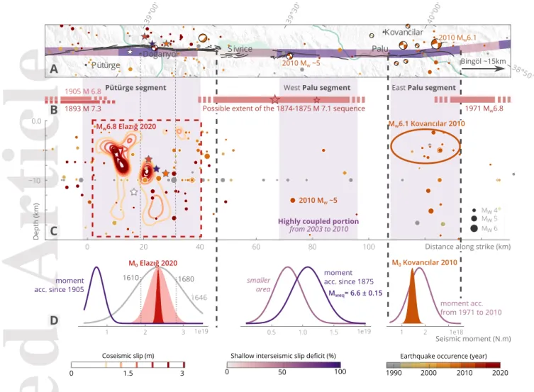
Figure 4. Comparison between the spatial distributions of the 2020 Elazı˘g earthquake rupture,
historical earthquakes, highly coupled sections of the EAF, and seismic moment accumulated since last
historical rupture in relation with seismic moment released by the most recent event. (A) Map view of
two segments the East Anatolian Fault (black lines), overlayed with historical and recent seismicity from
1900 to January 2020 (Retrieved from AFAD, 2020; NEIC, 2020; Melgar et al., 2020), shallow interseismic
slip deficit (Bletery et al., 2020) and our assumed fault trace for the 2020 Elazı˘g event (thick black line).
(B) Possible rupture extents for the 4 most recent Mw> 6.5 earthquakes that struck the mapped
seg-ments of the EAF before the Elazı˘g event, inferred from Ambraseys (1989); Hubert-Ferrari et al. (2020).
Red stars denote the locations of the mainshock and aftershock of the 1874 sequence (Ambraseys, 1989).
Fault segments of the central EAF are indicated, from Duman and Emre (2013). (C) Depth extent of the
slip amplitude inferred for the 2020 Elazı˘g event (Fig. 3), along with the highly coupled sections of the
EAF between 2003 and 2010 (Bletery et al., 2020), and the possible extent of the 2010 Mw6.1 Kovancılar
earthquake estimated from the spatial coverage of aftershocks and basic scaling laws (Wells &
Copper-smith, 1994; Tan et al., 2011), as well as historical and recent seismicity from 1900 to January 2020. (D)
For highly coupled portion of each segment, comparison of PDFs of accumulated seismic moment since
last historical rupture (in purple), with the seismic moment (M0) of last recent earthquakes, i.e. the 2020
Elazı˘g (red) or 2010 Kovancılar (orange) events. For the P¨ut¨urge segment, the PDF and mean of
accu-mulated seismic moment since the time needed to accumulate the Elazı˘g event M0are shown in gray, and
the PDFs of the Elazı˘g M0are derived from our preferred slip model (red), with a version accounting for
uncertainties in the shear modulus (µ = 2.8 ± 0.3 101GPa, light red).
4.1 A stochastic view of the 2020 Elazı˘g coseismic rupture
224
Assuming a realistic fault geometry and cristal structure, and accounting for
re-225
lated epistemic uncertainties, we estimate the slip distribution of the 2020 Elazı˘g
earth-226
quake with a Bayesian inference approach. We show that the coseismic rupture affects
227
almost the full width of the P¨ut¨urge segment, down to 15-km-depth, with a geodetic
mo-228
ment M0= 2.34 ± 0.25 1019N · m and an equivalent moment magnitude of 6.84 (µ =
229
2.8±0.3 101GPa). Two disconnected slip patches host most of the slip: one patch shows
230
slip exceeding 3 m from ∼ 3 to ∼ 10 km depth east of the main bend, while the second
231
slip patch extends from 7-km-depth down to 15-km-depth with slip amplitudes larger
232
than 2 m just west of the main bend (Fig. 3).
Accepted
Article
A large shallow slip (0-5 km, 2.5 m in amplitude) is also imaged around the
sec-234
ond bend. While the standard deviation associated with this shallow slip patch is
rel-235
atively small, its amplitude is poorly constrained by scarce, and possibly noisy, data points
236
largely affected by snowy conditions (Figs. S5, S6, S7). Some of our InSAR data
cov-237
ering up to one month after the mainshock, some imaged deformation, such as this
shal-238
low patch, might actually be postseismic. Yet, the surface displacement from 1 week to
239
5 months after the mainshock does not reach more than a few centimeters (Fig. S14),
240
suggesting that, if afterslip occurred, it was in the hours following the mainshock and
241
with a limited amplitude (as the amplitude of early afterslip often scales with the longer
242
term postseismic deformation, e.g., Twardzik et al., 2019), thus probably not excessively
243
affecting our slip estimates.
244
The inferred slip distribution changes significantly if we assume a planar fault
em-245
bedded in a homogeneous crust and we neglect uncertainties stemming from the
assump-246
tion of a simplified Earth interior. In particular, a single and shallower slip patch is
in-247
ferred around the epicenter, no slip larger than 50 cm being imaged above 2 km, or larger
248
than 80 cm below 10 km depth. The pronounced slip deficit imaged when assuming a
249
simplified forward model (Fig. S15) might suggest that the shallow slip deficit observed
250
by Pousse-Beltran et al. (2020) may be an artifact deriving from modeling choices, as
251
proposed by Xu et al. (2016) and Ragon et al. (2018).
252
The location of the epicenter, as estimated from different institutions and authors,
253
comes with more than 16 and 20 kilometers uncertainty in depth and position,
respec-254
tively (e.g., Jamalreyhani et al., 2020; Tatar et al., 2020). While some models proposed
255
a location around the main bend, many others proposed epicenters rather located in
be-256
tween the two bends (Fig. 3). Robust interpretation on rupture directivity is largely
af-257
fected by uncertainty in epicenters location, although our results suggest the rupture of
258
the Elazı˘g earthquake might be mostly unilateral to the SW.
259
Our estimates of the pattern of fault slip differ from other estimates based on
sim-260
ilar data (e.g., Melgar et al., 2020; Pousse-Beltran et al., 2020; Cheloni & Akinci, 2020;
261
Do˘gru et al., 2020). Our preferred model is very different from Pousse-Beltran et al. (2020);
262
Cheloni and Akinci (2020); Do˘gru et al. (2020), where peak slip reaches only 2 m over
263
the main bend. In contrast, our preferred model shares many characteristics with the
264
preferred one of Melgar et al. (2020), especially for the peak slip location and the
Accepted
Article
all shape of the ruptured areas, although they image large slip values east of the
KO-266
ERI epicenter. Melgar et al. (2020) preferred model being primarily driven by high-rate
267
GNSS data and assuming a 1D crustal structure, these shared characteristics suggest that
268
assuming a layered crustal model is necessary to infer robust slip estimates in this
re-269
gion.
270
4.2 Structurally driven slip on the P¨ut¨urge segment
271
Fault segmentation and bends are thought to act as geometric barriers that can
272
influence, or even drive, rupture initiation, termination and propagation (e.g., G. King
273
& Nabelek, 1985; A. A. Barka & Kadinsky-Cade, 1988; Wesnousky, 2006; Duan & Oglesby,
274
2005; Aochi et al., 2002; Perrin et al., 2016; Klinger, 2010). Similarly, creeping sections
275
might act as barriers to earthquake propagation (e.g., G. C. P. King, 1986; Chlieh et al.,
276
2008; Perfettini et al., 2010; Kaneko et al., 2010).
277
The coseismic rupture of the Elazı˘g earthquake likely started in a relatively
pla-278
nar portion of the fault, in between its two main bends (refer to Fig. 3, Jamalreyhani
279
et al., 2020). Similarly, peak slip amplitudes and most of the slip are located in relatively
280
smooth areas, and surround the main bend where well-resolved low slip values have been
281
imaged. The absence of slip in the main bend is a robust characteristic of our preferred
282
slip model, which has not been imaged in previous studies (e.g., Melgar et al., 2020). The
283
event thus likely ruptured a first portion of the P¨ut¨urge segment, stopped at the main
284
bend acting as a barrier, and then broke a second portion, a process that has been
ob-285
served in numerical simulations (e.g., Kato et al., 1999; Duan & Oglesby, 2005). A
per-286
turbation of the rupture propagation by the main bend well correlates with the
appar-287
ent rupture velocity decrease around the geometrical complexity (imaged by back-projection
288
of waveforms, Pousse-Beltran et al., 2020), and the two distinct peaks of the source time
289
function (automatically determined, Vall´ee & Douet, 2016).
290
Slip slowly decreases towards Lake Hazar (Fig. 4). Aftershocks activity also declines
291
abruptly at the basin boundary (Melgar et al., 2020; Jamalreyhani et al., 2020). The
pull-292
apart basin hosting Lake Hazar might thus have acted as a geometrical barrier to the
293
ruptured asperity (as also observed for the Haiyuan fault, China, Liu-Zeng et al., 2007;
294
Jolivet et al., 2013). To the west, no specific geometrical complexity is imaged at the
Accepted
Article
face, and the rupture may have stopped at the maximum length of the fault segment (Klinger,
296
2010).
297
Finally, the location of the main bend also corresponds to the portion of the EAF
298
that shows maximum shallow interseismic slip deficit ( >90%, Fig. 4). Inferred slip partly
299
overlays this portion of maximum slip deficit, but the coseismic rupture also extends over
300
moderately coupled regions (30-40%) at greater depths (from 8 to 15-km-depth). The
301
second bend, to the northeast of the main bend (Fig. 3), is also surrounded by large (>2
302
m) slip amplitudes at shallow depths.
303
Altogether, these observations suggest that the distribution of subsurface fault slip
304
during the Elazı˘g earthquake may largely reflect complexities in the fault geometry.
Rup-305
tured portions appear to be relatively smooth. In contrast, the main fault bend likely
306
acted as a barrier to rupture propagation, over which no slip has been imaged, similarly
307
to the structure responsible for the pull-apart basin of Lake Hazar. The bend is not prone
308
either to aseismic slip (at least at shallow depths). The deepest imaged slip patch, down
309
to 15-km-depth, confirms that the seismogenic depth is deeper than 10 km for the
cen-310
tral EAF (Bulut et al., 2012). Our results do not seem to corroborate the shallow
lock-311
ing depth (full creep below 5 km) inferred by Cavali´e and J´onsson (2014). This
behav-312
ior appears similar to the NAF, where large earthquakes occur on faults also prone to
313
aseismic slip (Cakir et al., 2005, 2014b; Schmittbuhl et al., 2016).
314
4.3 Seismic potential of the Palu segment
315
From P¨ut¨urge to Bing¨ol, interseismic slip deficit above 5-km-depth varies along strike,
316
as inferred from geodetic data from 2003 to 2010 (Bletery et al., 2020, Figs 4, S16). Three
317
main sections of large shallow interseismic slip deficit (>70%) are clearly distinct: one
318
on the P¨ut¨urge segment, another on the West Palu segment, and a last one east of the
319
city of Palu, on the East Palu segment. Before the Elazı˘g event, this portion of the EAF
320
was struck by 4 large earthquakes in the last 200 years. Two M ∼ 6.8 and M ∼ 7.3
oc-321
cured west of Lake Hazar in 1893 and 1905 (Ambraseys, 1989). In 1874-1875, a sequence
322
of two M ∼ 7.1 and M ∼ 6.7 likely struck the region between Sivrice and Palu (Ambraseys,
323
1989; Cetin et al., 2003; Hubert-Ferrari et al., 2017). East of the locality of Palu, the
re-324
gion around the city of Bing¨ol was affected by a Mw6.8 in 1971 (Ambraseys, 1989;
Am-325
braseys & Jackson, 1998).
Accepted
Article
Slip deficit has accumulated on the EAF since these recent historical ruptures, and
327
the newly coupled portions (from 2003 to 2010) are preferably located in between the
328
historically ruptured segments (Bletery et al., 2020). The 2010 Mw 6.1 earthquake that
329
occurred near Kovancılar (Akkar et al., 2011) appears to have filled the possible seismic
330
gap between the 1874 sequence and the 1971 Bing¨ol event (Fig. 4B). Similarly, the
ex-331
tent of the Elazı˘g rupture well overlays with a highly coupled portion of the EAF, and
332
it may have filled a possible gap between the 1893/1905 earthquakes and the 1874
se-333
quence (Melgar et al., 2020; Duman & Emre, 2013).
334
We compare the seismic moment accumulated since the possible last historic
rup-335
ture of the P¨ut¨urge segment (1905) with the seismic moment released during the 2020
336
Elazı˘g earthquake (Fig. 4D). To do so, we calculate the seismic moment for the area
rup-337
tured by the event according to our slip model, and account for uncertainties in ruptured
338
area (σ = 3 km2), shear modulus (µ = 2.8 ± 0.3 101 GPa), coupling and slip rates
339
(according to Bletery et al., 2020). The moment released by the 2020 event is largely greater
340
than the one accumulated since 1905 (2.34 ± 0.25 >> 0.72 ± 0.19 1019N · m). Around
341
475 years (since 1646) would be necessary to accumulate the moment released by the Elazı˘g
342
earthquake, assuming constant coupling and slip rates, confirming that the P¨ut¨urge
seg-343
ment did probably not rupture during the last historical events, and effectively was a
seis-344
mic gap. We make the same comparison for the East Palu segment, and show that the
345
moment released by the 2010 Mw 6.1 Kovancılar earthquake well matches the moment
346
accumulated from the 1971 Bing¨ol event to 2010 (1.58 ± 0.2 ≈ 2.19 ± 0.56 1018N · m,
347
Fig. 4D), suggesting this portion of the EAF actually ruptured during the 1971 event,
348
and that all of the accumulated moment has been released at the time of the Kovancılar
349
earthquake. Since 2010, the seismic moment of the East Palu segment likely
accumu-350
lated again to reach 4.48 ± 0.5 1017N · m, which corresponds to a Mw≈ 5.73
351
Although the portions of the EAF that have been affected by the Elazı˘g and
Ko-352
vancılar events show seismic activity in the 20 years preceding these events, the West
353
Palu segment is characterized by relatively low seismic activity (Fig. 4). Together with
354
the low slip deficit at depth (or shallow 5 km locking depth, Cavali´e & J´onsson, 2014;
355
Bletery et al., 2020), the lack of seismicity might suggest that the West Palu segment
356
is creeping. However, this segment also shows large interseismic slip deficit in its
shal-357
low portion (< 5-km-depth), and at greater depths even larger than for the P¨ut¨urge
seg-358
ment (before the 2020 event, Bletery et al., 2020, Fig. S16). Ground shaking maps
Accepted
Article
rived from press reports and testimonies suggest the 1874 sequence likely initiated at depth
360
just west of Lake Hazar (Ambraseys, 1989), near the epicenter of a Mw∼ 5 earthquake
361
that occurred in 2010. The West Palu segment is thus capable of producing large
earth-362
quakes. Cheloni and Akinci (2020) also suggest that the Elazı˘g event led to an increase
363
in the Coulomb stress of the Palu segment. Altogether, these observations suggest that
364
the West Palu segment of the central EAF is likely seismogenic. If it were to rupture,
365
the moment accumulated since 1875 on the highly coupled portion is of 7.58±2.2 1018N · m
366
(light purple in Fig. 4D), and may reach 1.08 ± 0.25 1019N · m if the rupture extends
367
from Lake Hazar to the city of Palu (dark purple in Fig. 4D), which would correspond
368
to a Mw∼ 6.6 ± 0.15 earthquake.
369
Acknowledgments
370
The slip model and data are available at https://doi.org/10.5281/zenodo.4114109.
371
We thank an anonymous reviewer and Brendan Crowell for thorough reviews. We are
372
very grateful to Diego Melgar and Brendan Crowell who calculated and provided the GNSS
373
offsets for the coseismic deformation, and their relocated aftershocks catalog, which are
374
both available in Melgar et al. (2020). GNSS data were made available from the
Turk-375
ish National Permanent GNSS/RTK Network (TUSAGA-Aktif/CORS-TR administrated
376
by General Directorate of Land Registry and Cadastre-TKGM and General Directorate
377
of Mapping-HGM, Ankara, Turkey), thanks to Prof. Tuncay Taymaz and Prof. Taylan
378
calan. Initial aftershocks and phase-arrival catalog has been provided by the Disaster
379
and Emergency Management Presidency of Turkey (AFAD, 2020) for the period 24
Jan-380
uary 2020 11 February 2020, and historical/background seismicity catalog was provided
381
by BU-KOERI (http://www.koeri.boun.edu.tr/sismo/2/en/) for Turkey from 1992
382
to 2020. This work contains modified Copernicus data from the Sentinel-1A and -1B
satel-383
lites provided by the European Space Agency (ESA) that are accessible at earth.esa
384
.int/eogateway/. Original ALOS-2 data and products are copyright JAXA and
pro-385
vided under JAXA ALOS Research Announcement 6 (RA6) project 3278. The Bayesian
386
simulations were performed with the AlTar2 package (github.com/lijun99/altar2-documentation,
387
only accessible via github at publication date). The Classic Slip Inversion (CSI, github
388
.com/jolivetr/csi, only accessible via github at publication date) Python library (Jolivet
389
et al., 2014) was used to build inputs for the Bayesian algorithm, in particular to
com-390
pute Green’s functions. The python module PyDistMesh has been used to build the fault
Accepted
Article
geometry (Persson & Strang, 2004). Figures were generated with the Matplotlib and Seaborn
392
(doi:10.5281/zenodo.1313201) Python libraries and with the Generic Mapping Tools
393
library (Wessel et al., 2019). MS was partially supported by the National Aeronautics
394
and Space Administration under Grant No. 80NSSC19K1499. EF was partially supported
395
by the National Aeronautics and Space Administration Earth Surface and Interior
fo-396
cus area under Grant No. 80NM0018D0004. QB work has been supported by the French
397
government, through the UCA JEDI Investments in the Future project managed by the
398
National Research Agency (ANR) ANR-15-IDEX-01, the ANR S5 Grant No.
ANR-19-399
CE31-0003, and the ANR JCJC E-POST Grant No. ANR-14-CE03-002-01JCJC.
400
References
401
AFAD. (2020). AFAD Earthquake catalogue (1900–Feb 2020),
402
Prime Ministry, Disaster and Emergency Management Pres-.
403
https://deprem.afad.gov.tr/depremkatalogu?lang=en#.
404
Akkar, S., Aldemir, A., Askan, A., Bakır, S., Canbay, E., Demirel, ˙I. O., . . . Yenier,
405
E. (2011). 8 March 2010 Elazı˘g-Kovancılar (Turkey) Earthquake: Observations
406
on Ground Motions and Building Damage. Seismological Research Letters,
407
82 (1), 42–58. doi: 10.1785/gssrl.82.1.42
408
Aktug, B., Ozener, H., Dogru, A., Sabuncu, A., Turgut, B., Halicioglu, K., . . .
Hava-409
zli, E. (2016). Slip rates and seismic potential on the East Anatolian Fault
410
System using an improved GPS velocity field. Journal of Geodynamics, 94-95 ,
411
1–12. doi: 10.1016/j.jog.2016.01.001
412
Ambraseys, N. N. (1970). Some characteristic features of the Anatolian fault zone.
413
Tectonophysics, 9 (2), 143–165. doi: 10.1016/0040-1951(70)90014-4
414
Ambraseys, N. N. (1989). Temporary seismic quiescence: SE Turkey. Geophysical
415
Journal International , 96 (2), 311–331. doi: 10.1111/j.1365-246X.1989.tb04453
416
.x
417
Ambraseys, N. N., & Jackson, J. A. (1998). Faulting associated with historical and
418
recent earthquakes in the Eastern Mediterranean region. Geophysical Journal
419
International , 133 (2), 390–406. doi: 10.1046/j.1365-246X.1998.00508.x
420
Aochi, H., Madariaga, R., & Fukuyama, E. (2002). Effect of normal stress during
421
rupture propagation along nonplanar faults. Journal of Geophysical Research:
422
Solid Earth, 107 (B2), ESE 5-1-ESE 5-10. doi: 10.1029/2001JB000500
Accepted
Article
Armijo, R., Meyer, B., Hubert, A., & Barka, A. (1999). Westward propagation
424
of the North Anatolian fault into the northern Aegean: Timing and
kine-425
matics. Geology, 27 (3), 267–270. doi: 10.1130/0091-7613(1999)027h0267:
426
WPOTNAi2.3.CO;2
427
Barka, A. (1996). Slip distribution along the North Anatolian fault associated with
428
the large earthquakes of the period 1939 to 1967. Bulletin of the Seismological
429
Society of America, 86 (5), 1238–1254.
430
Barka, A. A., & Kadinsky-Cade, K. (1988). Strike-slip fault geometry in Turkey and
431
its influence on earthquake activity. Tectonics, 7 (3), 663–684. doi: 10.1029/
432
TC007i003p00663
433
Basilic, R., Kastelic, V., Demircioglu, M. B., Garcia Moreno, D., Nemser, E. S.,
434
Petricca, P., . . . W¨ossner, J. (2013). The European Database of Seismogenic
435
Faults (EDSF) compiled in the framework of the Project SHARE.
436
doi: 10.6092/INGV.IT-SHARE-EDSF
437
Beresnev, I. A. (2003). Uncertainties in Finite-Fault Slip Inversions: To What
Ex-438
tent to Believe? (A Critical Review). Bulletin of the Seismological Society of
439
America, 93 (6), 2445–2458. doi: 10.1785/0120020225
440
Bletery, Q., Cavali´e, O., Nocquet, J.-M., & Ragon, T. (2020). Distribution of
In-441
terseismic Coupling Along the North and East Anatolian Faults Inferred From
442
InSAR and GPS Data. Geophysical Research Letters, 47 (16), e2020GL087775.
443
doi: 10.1029/2020GL087775
444
Bulut, F., Bohnhoff, M., Eken, T., Janssen, C., Kılı¸c, T., & Dresen, G. (2012).
445
The East Anatolian Fault Zone: Seismotectonic setting and spatiotemporal
446
characteristics of seismicity based on precise earthquake locations. Journal of
447
Geophysical Research: Solid Earth, 117 (B7). doi: 10.1029/2011JB008966
448
Cakir, Z., Akoglu, A. M., Belabbes, S., Ergintav, S., & Meghraoui, M. (2005).
449
Creeping along the Ismetpasa section of the North Anatolian fault (Western
450
Turkey): Rate and extent from InSAR. Earth and Planetary Science Letters,
451
238 (1), 225–234. doi: 10.1016/j.epsl.2005.06.044
452
Cakir, Z., Ergintav, S., Ako˘glu, A. M., C¸ akmak, R., Tatar, O., & Meghraoui, M.
453
(2014a). InSAR velocity field across the North Anatolian Fault (eastern
454
Turkey): Implications for the loading and release of interseismic strain
accumu-455
lation. Journal of Geophysical Research: Solid Earth, 119 (10), 7934–7943. doi:
Accepted
Article
10.1002/2014JB011360
457
Cakir, Z., Ergintav, S., Ako˘glu, A. M., C¸ akmak, R., Tatar, O., & Meghraoui, M.
458
(2014b). InSAR velocity field across the North Anatolian Fault (eastern
459
Turkey): Implications for the loading and release of interseismic strain
accumu-460
lation. Journal of Geophysical Research: Solid Earth, 119 (10), 7934–7943. doi:
461
10.1002/2014JB011360
462
Causse, M., Cotton, F., & Mai, P. M. (2010). Constraining the roughness degree of
463
slip heterogeneity. Journal of Geophysical Research: Solid Earth, 115 (B5). doi:
464
10.1029/2009JB006747
465
Cavali´e, O., & J´onsson, S. (2014). Block-like plate movements in eastern
Anato-466
lia observed by InSAR. Geophysical Research Letters, 26–31. doi: 10.1002/
467
2013GL058170@10.1002/(ISSN)1944-8007.GRLeditorhghlts2014
468
Cetin, H., G¨uneyli, H., & Mayer, L. (2003). Paleoseismology of the Palu–Lake Hazar
469
segment of the East Anatolian Fault Zone, Turkey. Tectonophysics, 374 (3),
470
163–197. doi: 10.1016/j.tecto.2003.08.003
471
Cheloni, D., & Akinci, A. (2020). Source modelling and strong ground motion
simu-472
lations for the January 24, 2020, Mw 6.8 Elazı˘g earthquake, Turkey.
Geophysi-473
cal Journal International . doi: 10.1093/gji/ggaa350
474
Chlieh, M., Avouac, J. P., Sieh, K., Natawidjaja, D. H., & Galetzka, J. (2008).
Het-475
erogeneous coupling of the Sumatran megathrust constrained by geodetic and
476
paleogeodetic measurements. Journal of Geophysical Research: Solid Earth,
477
113 (B5). doi: 10.1029/2007JB004981
478
Diao, F., Wang, R., Aochi, H., Walter, T. R., Zhang, Y., Zheng, Y., & Xiong, X.
479
(2016). Rapid kinematic finite-fault inversion for an Mw 7+ scenario
earth-480
quake in the Marmara Sea: An uncertainty study. Geophysical Journal
Inter-481
national , 204 (2), 813–824. doi: 10.1093/gji/ggv459
482
Do˘gru, A., Bulut, F., Yaltırak, C., & Aktu˘g, B. (2020). Slip distribution of
483
the 2020 Elazı˘g Earthquake (MW 6.75) and its influence on earthquake
484
hazard in the Eastern Anatolia. Geophysical Journal International . doi:
485
10.1093/gji/ggaa471
486
Doin, M.-P., Lodge, F., Guillaso, S., Jolivet, R., Lasserre, C., Ducret, G., . . . Pinel,
487
V. (2012). Presentation Of The Small Baseline NSBAS Processing Chain On A
488
Case Example: The ETNA Deformation Monitoring From 2003 to 2010 Using
Accepted
Article
ENVISAT Data. , 697 , 98.
490
Du, Y., Aydin, A., & Segall, P. (1992). Comparison of various inversion techniques
491
as applied to the determination of a geophysical deformation model for the
492
1983 Borah Peak earthquake. Bulletin of the Seismological Society of America,
493
82 (4), 1840–1866.
494
Duan, B., & Oglesby, D. D. (2005). Multicycle dynamics of nonplanar strike-slip
495
faults. Journal of Geophysical Research: Solid Earth, 110 (B3). doi: 10.1029/
496
2004JB003298
497
Duman, T. Y., & Emre, ¨O. (2013). The East Anatolian Fault: Geometry,
segmen-498
tation and jog characteristics. Geological Society, London, Special Publications,
499
372 (1), 495–529. doi: 10.1144/SP372.14
500
Duputel, Z., Agram, P. S., Simons, M., Minson, S. E., & Beck, J. L. (2014).
Ac-501
counting for prediction uncertainty when inferring subsurface fault slip.
Geo-502
physical Journal International , 197 (1), 464–482. doi: 10.1093/gji/ggt517
503
Dziewonski, A. M., Chou, T.-A., & Woodhouse, J. H. (1981). Determination of
504
earthquake source parameters from waveform data for studies of global and
505
regional seismicity. Journal of Geophysical Research: Solid Earth, 86 (B4),
506
2825–2852. doi: 10.1029/JB086iB04p02825
507
Galloviˇc, F., Imperatori, W., & Mai, P. M. (2015). Effects of three-dimensional
508
crustal structure and smoothing constraint on earthquake slip inversions: Case
509
study of the Mw6.3 2009 L’Aquila earthquake. Journal of Geophysical
Re-510
search: Solid Earth, 120 (1), 2014JB011650. doi: 10.1002/2014JB011650
511
Garcia Moreno, D., Hubert, A., Moernaut, J., Fraser, J., Boes, X., Van Daele,
512
M., . . . De Batist, M. (2011). Structure and evolution of Lake Hazar
pull-513
apart Basin along the East Anatolian Fault. Basin Research, 23 . doi:
514
10.1111/j.1365-2117.2010.00476.x
515
Hartzell, S., Liu, P., Mendoza, C., Ji, C., & Larson, K. M. (2007). Stability and
516
Uncertainty of Finite-Fault Slip Inversions: Application to the 2004 Parkfield,
517
California, Earthquake. Bulletin of the Seismological Society of America,
518
97 (6), 1911–1934. doi: 10.1785/0120070080
519
Hubert-Ferrari, A., Lamair, L., Hage, S., Schmidt, S., C¸ a˘gatay, M. N., & Av¸sar, U.
520
(2020). A 3800 yr paleoseismic record (Lake Hazar sediments, eastern Turkey):
521
Implications for the East Anatolian Fault seismic cycle. Earth and Planetary
Accepted
Article
Science Letters, 538 , 116152. doi: 10.1016/j.epsl.2020.116152
523
Hubert-Ferrari, A., El-Ouahabi, M., Garcia-Moreno, D., Av¸sar, U., Altınok, S.,
524
Schmidt, S., . . . C¸ a˘gatay, M. N. (2017). Earthquake imprints on a lacustrine
525
deltaic system: The K¨urk Delta along the East Anatolian Fault (Turkey).
526
Sedimentology, 64 (5), 1322–1353. doi: 10.1111/sed.12355
527
Hussain, E., Wright, T. J., Walters, R. J., Bekaert, D. P. S., Lloyd, R., & Hooper,
528
A. (2018). Constant strain accumulation rate between major earthquakes
529
on the North Anatolian Fault. Nature Communications, 9 (1), 1392. doi:
530
10.1038/s41467-018-03739-2
531
Jamalreyhani, M., B¨uy¨ukakpınar, P., Cesca, S., Dahm, T., Sudhaus, H., Rezapour,
532
M., . . . Heimann, S. (2020). Seismicity related to the eastern sector of
Ana-533
tolian escape tectonic: The example of the 24 January 2020 Mw 6.77 Elazı˘
g-534
Sivrice earthquake. Solid Earth Discussions, 1–22. doi: 10.5194/se-2020-55
535
Jolivet, R., Duputel, Z., Riel, B., Simons, M., Rivera, L., Minson, S. E., . . . Fielding,
536
E. J. (2014). The 2013 Mw 7.7 Balochistan Earthquake: Seismic Potential
537
of an Accretionary Wedge. Bulletin of the Seismological Society of America,
538
104 (2), 1020–1030. doi: 10.1785/0120130313
539
Jolivet, R., Lasserre, C., Doin, M.-P., Guillaso, S., Peltzer, G., Dailu, R., . . . Xu,
540
X. (2012). Shallow creep on the Haiyuan Fault (Gansu, China) revealed by
541
SAR Interferometry. Journal of Geophysical Research: Solid Earth, 117 (B6),
542
B06401. doi: 10.1029/2011JB008732
543
Jolivet, R., Lasserre, C., Doin, M. P., Peltzer, G., Avouac, J. P., Sun, J., & Dailu,
544
R. (2013). Spatio-temporal evolution of aseismic slip along the Haiyuan fault,
545
China: Implications for fault frictional properties. Earth and Planetary Science
546
Letters, 377-378 , 23–33. doi: 10.1016/j.epsl.2013.07.020
547
Kaneko, Y., Avouac, J.-P., & Lapusta, N. (2010). Towards inferring earthquake
pat-548
terns from geodetic observations of interseismic coupling. Nature Geoscience,
549
3 (5), 363–369. doi: 10.1038/ngeo843
550
Kaneko, Y., Fialko, Y., Sandwell, D. T., Tong, X., & Furuya, M. (2013).
Inter-551
seismic deformation and creep along the central section of the North
Anato-552
lian Fault (Turkey): InSAR observations and implications for rate-and-state
553
friction properties. Journal of Geophysical Research: Solid Earth, 118 (1),
554
316–331. doi: 10.1029/2012JB009661
Accepted
Article
Kato, N., Satoh, T., Lei, X., Yamamoto, K., & Hirasawa, T. (1999). Effect of fault
556
bend on the rupture propagation process of stick-slip. Tectonophysics, 310 (1),
557
81–99. doi: 10.1016/S0040-1951(99)00149-3
558
King, G., & Nabelek, J. (1985). Role of Fault Bends in the Initiation and
Termina-559
tion of Earthquake Rupture. Science, 228 (4702), 984–987. doi: 10.1126/science
560
.228.4702.984
561
King, G. C. P. (1986). Speculations on the geometry of the initiation and
termi-562
nation processes of earthquake rupture and its relation to morphology and
563
geological structure. pure and applied geophysics, 124 (3), 567–585. doi:
564
10.1007/BF00877216
565
Klinger, Y. (2010). Relation between continental strike-slip earthquake
segmenta-566
tion and thickness of the crust. Journal of Geophysical Research: Solid Earth,
567
115 (B7). doi: 10.1029/2009JB006550
568
Langer, L., Ragon, T., Sladen, A., & Tromp, J. (2020). Impact of topography on
569
earthquake static slip estimates. Tectonophysics, 228566. doi: 10.1016/j.tecto
570
.2020.228566
571
Liang, C., & Fielding, E. J. (2017a). Interferometry With ALOS-2 Full-Aperture
572
ScanSAR Data. IEEE Transactions on Geoscience and Remote Sensing, 55 (5),
573
2739–2750. doi: 10.1109/TGRS.2017.2653190
574
Liang, C., & Fielding, E. J. (2017b). Measuring Azimuth Deformation With L-Band
575
ALOS-2 ScanSAR Interferometry. IEEE Transactions on Geoscience and
Re-576
mote Sensing, 55 (5), 2725–2738. doi: 10.1109/TGRS.2017.2653186
577
Liu-Zeng, J., Klinger, Y., Xu, X., Lasserre, C., Chen, G., Chen, W., . . . Zhang, B.
578
(2007). Millennial Recurrence of Large Earthquakes on the Haiyuan Fault near
579
Songshan, Gansu Province, China. Bulletin of the Seismological Society of
580
America, 97 (1B), 14–34. doi: 10.1785/0120050118
581
Lohman, R. B., & Simons, M. (2005). Some thoughts on the use of InSAR data
582
to constrain models of surface deformation: Noise structure and data
down-583
sampling. Geochemistry, Geophysics, Geosystems, 6 (1), Q01007. doi:
584
10.1029/2004GC000841
585
Maden, N. (2012). One-Dimensional Thermal Modeling of the Eastern Pontides
Oro-586
genic Belt (NE Turkey). Pure and Applied Geophysics, 169 (1), 235–248. doi:
587
10.1007/s00024-011-0296-0
Accepted
Article
Mai, P. M., Schorlemmer, D., Page, M., Ampuero, J.-P., Asano, K., Causse, M., . . .
589
Zielke, O. (2016). The Earthquake-Source Inversion Validation (SIV) Project.
590
Seismological Research Letters. doi: 10.1785/0220150231
591
McClusky, S., Balassanian, S., Barka, A., Demir, C., Ergintav, S., Georgiev, I., . . .
592
Veis, G. (2000). Global Positioning System constraints on plate kinematics and
593
dynamics in the eastern Mediterranean and Caucasus. Journal of Geophysical
594
Research: Solid Earth, 105 (B3), 5695–5719. doi: 10.1029/1999JB900351
595
McKenzie, D. (1972). Active Tectonics of the Mediterranean Region. Geophysical
596
Journal International , 30 (2), 109–185. doi: 10.1111/j.1365-246X.1972.tb02351
597
.x
598
Mckenzie, D. P. (1970). Plate Tectonics of the Mediterranean Region. Nature,
599
226 (5242), 239–243. doi: 10.1038/226239a0
600
Melgar, D., Ganas, A., Taymaz, T., Valkaniotis, S., Crowell, B. W.,
Kapetani-601
dis, V., . . . ¨Ocalan, T. (2020). Rupture kinematics of January 24, 2020
602
Mw 6.7 Do˘ganyol-Sivrice, Turkey earthquake on the East Anatolian Fault
603
zone imaged by space geodesy. Geophysical Journal International . doi:
604
10.1093/gji/ggaa345
605
Minson, S. E., Simons, M., & Beck, J. L. (2013). Bayesian inversion for finite fault
606
earthquake source models I – theory and algorithm. Geophysical Journal
Inter-607
national , 194 (3), 1701–1726. doi: 10.1093/gji/ggt180
608
Minson, S. E., Simons, M., Beck, J. L., Ortega, F., Jiang, J., Owen, S. E., . . .
609
Sladen, A. (2014). Bayesian inversion for finite fault earthquake source
mod-610
els – II: The 2011 great Tohoku-oki, Japan earthquake. Geophysical Journal
611
International , 198 (2), 922–940. doi: 10.1093/gji/ggu170
612
NEIC. (2020). NEIC Earthquake catalogue. National Earthquake Information
Cen-613
tre, On-line Bulletin,. https://earthquake.usgs.gov/earthquakes/search/.
614
Ozer, C., Ozyazicioglu, M., Gok, E., & Polat, O. (2019). Imaging the Crustal
615
Structure Throughout the East Anatolian Fault Zone, Turkey, by Local
Earth-616
quake Tomography. Pure and Applied Geophysics, 176 (6), 2235–2261. doi:
617
10.1007/s00024-018-2076-6
618
Perfettini, H., Avouac, J.-P., Tavera, H., Kositsky, A., Nocquet, J.-M., Bondoux, F.,
619
. . . Soler, P. (2010). Seismic and aseismic slip on the Central Peru megathrust.
620
Nature, 465 (7294), 78–81.
Accepted
Article
Perrin, C., Manighetti, I., & Gaudemer, Y. (2016). Off-fault tip splay
net-622
works: A genetic and generic property of faults indicative of their
long-623
term propagation. Comptes Rendus Geoscience, 348 (1), 52–60. doi:
624
10.1016/j.crte.2015.05.002
625
Persson, P.-O., & Strang, G. (2004). A Simple Mesh Generator in MATLAB. SIAM
626
Review , 46 (2), 329–345. doi: 10.1137/S0036144503429121
627
Pousse-Beltran, L., Nissen, E., Bergman, E. A., Cambaz, M. D., Gaudreau, ´E.,
628
Karas¨ozen, E., & Tan, F. (2020). The 2020 Mw 6.8 Elazı˘g (Turkey)
Earth-629
quake Reveals Rupture Behavior of the East Anatolian Fault. Geophysical
630
Research Letters, 47 (13), e2020GL088136. doi: 10.1029/2020GL088136
631
Ragon, T., Sladen, A., Bletery, Q., Vergnolle, M., Cavali´e, O., Avallone, A., . . .
De-632
louis, B. (2019). Joint Inversion of Coseismic and Early Postseismic Slip to
633
Optimize the Information Content in Geodetic Data: Application to the 2009
634
Mw6.3 L’Aquila Earthquake, Central Italy. Journal of Geophysical Research:
635
Solid Earth, 124 (10), 10522–10543. doi: 10.1029/2018JB017053
636
Ragon, T., Sladen, A., & Simons, M. (2018). Accounting for uncertain fault
637
geometry in earthquake source inversions – I: Theory and simplified
ap-638
plication. Geophysical Journal International , 214 (2), 1174–1190. doi:
639
10.1093/gji/ggy187
640
Ragon, T., Sladen, A., & Simons, M. (2019). Accounting for uncertain fault
geom-641
etry in earthquake source inversions – II: Application to the Mw 6.2 Amatrice
642
earthquake, central Italy. Geophysical Journal International , 218 (1), 689–707.
643
doi: 10.1093/gji/ggz180
644
Razafindrakoto, H. N. T., & Mai, P. M. (2014). Uncertainty in Earthquake Source
645
Imaging Due to Variations in Source Time Function and Earth Structure.
Bul-646
letin of the Seismological Society of America, 104 (2), 855–874. doi: 10.1785/
647
0120130195
648
Reilinger, R., McClusky, S., Vernant, P., Lawrence, S., Ergintav, S., Cakmak, R., . . .
649
Karam, G. (2006). GPS constraints on continental deformation in the
Africa-650
Arabia-Eurasia continental collision zone and implications for the dynamics of
651
plate interactions. Journal of Geophysical Research: Solid Earth, 111 (B5). doi:
652
10.1029/2005JB004051
Accepted
Article
Rosen, P. A. G. (2012). The InSAR Scientific Computing Environment. In 9th
Eu-654
ropean Conference on Synthetic Aperture Radar. Nuremberg, Germany.
655
Schmittbuhl, J., Karabulut, H., Lenglin´e, O., & Bouchon, M. (2016). Long-lasting
656
seismic repeaters in the Central Basin of the Main Marmara Fault. Geophysical
657
Research Letters, 43 (18), 9527–9534. doi: 10.1002/2016GL070505
658
S¸eng¨or, A., T¨uys¨uz, O., ˙Imren, C., Sakın¸c, M., Eyido˘gan, H., G¨or¨ur, N., . . .
659
Rangin, C. (2005). The North Anatolian Fault: A New Look. Annual
660
Review of Earth and Planetary Sciences, 33 (1), 37–112. doi: 10.1146/
661
annurev.earth.32.101802.120415
662
Stein, R. S., Barka, A. A., & Dieterich, J. H. (1997). Progressive failure on the
663
North Anatolian fault since 1939 by earthquake stress triggering. Geophysical
664
Journal International , 128 (3), 594–604. doi: 10.1111/j.1365-246X.1997.tb05321
665
.x
666
Tan, O., Pabu¸ccu, Z., Tapırdamaz, M. C., ˙Inan, S., Ergintav, S., Eyido˘gan, H., . . .
667
Kulu¨ozt¨urk, F. (2011). Aftershock study and seismotectonic implications
668
of the 8 March 2010 Kovancılar (Elazı˘g, Turkey) earthquake (MW = 6.1).
669
Geophysical Research Letters, 38 (11). doi: 10.1029/2011GL047702
670
Tarantola, A. (2005). Inverse Problem Theory and Methods for Model Parameter
Es-671
timation. Society for Industrial and Applied Mathematics.
672
Tatar, O., S¨ozbilir, H., Ko¸cbulut, F., Bozkurt, E., Aksoy, E., Eski, S., . . . Metin, Y.
673
(2020). Surface deformations of 24 January 2020 Sivrice (Elazı˘g)–Do˘ganyol
674
(Malatya) earthquake (Mw = 6.8) along the P¨ut¨urge segment of the East
Ana-675
tolian Fault Zone and its comparison with Turkey’s 100-year-surface ruptures.
676
Mediterranean Geoscience Reviews. doi: 10.1007/s42990-020-00037-2
677
Twardzik, C., Vergnolle, M., Sladen, A., & Avallone, A. (2019). Unravelling the
con-678
tribution of early postseismic deformation using sub-daily GNSS positioning
679
—. Scientific Reports, 9 (1), 1775. doi: 10.1038/s41598-019-39038-z
680
Vall´ee, M., & Douet, V. (2016). A new database of source time functions (STFs)
ex-681
tracted from the SCARDEC method. Physics of the Earth and Planetary
Inte-682
riors, 257 , 149–157. doi: 10.1016/j.pepi.2016.05.012
683
Walters, R. J., Holley, R. J., Parsons, B., & Wright, T. J. (2011). Interseismic strain
684
accumulation across the North Anatolian Fault from Envisat InSAR
measure-685
ments. Geophysical Research Letters, 38 (5). doi: 10.1029/2010GL046443
Accepted
Article
Wells, D. L., & Coppersmith, K. J. (1994). New empirical relationships among
mag-687
nitude, rupture length, rupture width, rupture area, and surface displacement.
688
Bulletin of the Seismological Society of America, 84 (4), 974–1002.
689
Wesnousky, S. G. (2006). Predicting the endpoints of earthquake ruptures. Nature,
690
444 (7117), 358–360. doi: 10.1038/nature05275
691
Wessel, P., Luis, J. F., Uieda, L., Scharroo, R., Wobbe, F., Smith, W. H. F., & Tian,
692
D. (2019). The Generic Mapping Tools Version 6. Geochemistry, Geophysics,
693
Geosystems, n/a(n/a). doi: 10.1029/2019GC008515
694
Wright, T., Parsons, B., & Fielding, E. (2001). Measurement of interseismic
695
strain accumulation across the North Anatolian Fault by satellite radar
696
interferometry. Geophysical Research Letters, 28 (10), 2117–2120. doi:
697
10.1029/2000GL012850
698
Xu, X., Tong, X., Sandwell, D. T., Milliner, C. W. D., Dolan, J. F., Hollingsworth,
699
J., . . . Ayoub, F. (2016). Refining the shallow slip deficit. Geophysical Journal
700
International , 204 (3), 1867–1886. doi: 10.1093/gji/ggv563
701
Yagi, Y., & Fukahata, Y. (2008). Importance of covariance components in
inver-702
sion analyses of densely sampled observed data: An application to waveform
703
data inversion for seismic source processes. Geophysical Journal International ,
704
175 (1), 215–221. doi: 10.1111/j.1365-246X.2008.03884.x
705
Yilmaz, H., Over, S., & Ozden, S. (2006). Kinematics of the East Anatolian
706
Fault Zone between Turkoglu (Kahramanmaras) and Celikhan
(Adiya-707
man), eastern Turkey. Earth, Planets and Space, 58 (11), 1463–1473. doi:
708
10.1186/BF03352645
709
Zhu, L., & Rivera, L. A. (2002). A note on the dynamic and static displacements
710
from a point source in multilayered media. Geophysical Journal International ,
711
148 (3), 619–627. doi: 10.1046/j.1365-246X.2002.01610.x