HAL Id: hal-02818768
https://hal.inrae.fr/hal-02818768
Submitted on 6 Jun 2020HAL is a multi-disciplinary open access archive for the deposit and dissemination of sci-entific research documents, whether they are pub-lished or not. The documents may come from teaching and research institutions in France or abroad, or from public or private research centers.
L’archive ouverte pluridisciplinaire HAL, est destinée au dépôt et à la diffusion de documents scientifiques de niveau recherche, publiés ou non, émanant des établissements d’enseignement et de recherche français ou étrangers, des laboratoires publics ou privés.
To cite this version:
CCE Progress Report 2007 Page 1 of 201
MNP Report 500090001/2007
Critical Loads of Nitrogen and Dynamic Modelling CCE Progress Report 2007
J. Slootweg, M. Posch, J.-P. Hettelingh (eds.)
Contact: J. Slootweg CCE/LED
wge
Working Group on Effectsof theConvention on Long-range Transboundary Air Pollution
ISBN: 978-90-6960-175-5
© MNP 2007
Parts of this publication may be reproduced, on condition of acknowledgement: 'Netherlands Environmental Assessment Agency, the title of the publication and year of publication.'
This investigation has been performed by order and for the account of the Directorate for Climate Change and Industry of the Dutch Ministry of Housing, Spatial Planning and the Environment within the framework of MNP project M/500090, Coordination Centre for Effects (CCE); for the account of the European Commission LIFE+ programme within the framework of MNP project E/555065 European Consortium for Modelling Air Pollution and Climate Strategies (EC4MACS) and for the account of (the Working Group on Effects within) the trust fund for the partial funding of effect-oriented activities under the Convention on Long-range Transboundary Air Pollution.
CCE Progress Report 2007 Page 3 of 201
Contents
Acknowledgements ... 4
Abstract ... 5
Rapport in het kort ... 6
Introduction ... 7
Part I Status of Maps and Methods 1. Status of European critical loads with focus on nitrogen... 9
2. Summary of national data ... 21
3. Critical loads and dynamic modelling of nitrogen... 41
4. Tentatively exploring the likelihood of exceedances: Ensemble Assessment of Impacts (EAI) ... 53
5. LRTAP land cover map of Europe ... 59
6. Application of the harmonized land cover map ... 71
7. Background database for computing critical loads for the EECCA countries, Turkey and Cyprus... 89
Part II National Focal Centre Reports ... 103
AUSTRIA ... 104 BELGIUM (Wallonia) ... 111 BULGARIA ... 115 CANADA... 121 CYPRUS ... 123 CZECH REPUBLIC ... 129 GERMANY... 133 FRANCE ... 139 IRELAND ... 144 ITALY... 146 LATVIA... 149 THE NETHERLANDS ... 153 NORWAY... 155 POLAND ... 159 RUSSIA ... 161 SLOVENIA... 166 SWEDEN ... 170 SWITZERLAND ... 174 UNITED KINGDOM... 180
Appendix A. Instructions for submitting empirical critical loads of nitrogen... 189
Appendix B. Instructions for submitting critical loads of N and S and dynamic modelling data... 191
Appendix C. Guidance notes for lead authors of the IPCC fourth assessment report on addressing uncertainties... 198
FRANCE
National Focal Centre
Anne Probst — Sophie Leguédois ECOLAB (UMR 5245 CNRS/UPS/INPT) ENSAT-INP Av de l'Agrobiopole Auzeville-Tolosane BP 32607 F-31326 Castanet-Tolosan cedex [email protected] [email protected] Jean-Paul Party Sol-Conseil
251 rte La Wantzenau - Robertsau
Collaborating institutions
Laurence Galsomiès — Christian Elichegaray ADEME
Centre de Paris - Vanves
Département Surveillance de la Qualité de l'Air 27, rue Louis Vicat
F-75737 Paris cedex 15 Étienne Dambrine INRA-Centre de Nancy
Équipe Biogéochimie des Écosystèmes Forestiers F-54280 Champenoux
Erwin Ulrich — Luc Croisé Office National des Forêts Direction Technique
Département Recherche et Développement Réseau RENECOFOR
Boulevard de Constance F-77300 Fontainebleau Louis-Michel Nageleisen
Ministère de l'Agriculture, de l'Alimentation, de la Pêche et des Affaires Rurales (DGFAR) Département de la Santé des Forêts Antenne
Spécialisée Cenre INRA de Nancy F-54280 Champenoux Anne-Christine Le Gall
Direction des Risques Chroniques Unité MECO
INERIS BP N°2
F-60550 Verneuil-en-Halatte Marc Rico — Hélène Cadière
Ministère de l'Ecologie et du Développement Durable Bureau de la pollution atmosphérique, des
équipements énergétiques et des transports Direction de la Pollution et de la Prévention des
Risques 20, avenue de Ségur F-75007 Paris
Modelled critical loads and dynamic modelling data
The objectives of this call for data were to submit updated critical loads and to provide time series of modelled chemical variables for different deposition scenarios, i.e. dynamic modelling results. In 2005, the French National Focal Centre (NFC) provided updated critical load values for nitrogen (acid and nutrient) and sulphur as well as dynamic modelling results (Probst et al., 2005). In 2007, the French NFC: (1) tested the updated critical concentrations for the calculation of critical loads of nutrient nitrogen proposed by the Coordination Centre for Effects (CCE) and, (2) sent data for dynamic modelling. In comparison with 2005, the only major change is the removal of costal ecosystems (EUNIS code B1.4) from the dynamic modelling database as, for those ecosystems, critical loads were determined empirically (Probst et al., 2005).
Page 140 of 201 CCE Progress Report 2007 Calculation method
The data were computed following the method used in 2005 by the French NFC (Probst et al., 2005) which is in accordance with the Mapping Manual (UBA, 2004). For steady state critical loads, the Steady State Mass Balance (SSMB) model was applied on the soil top-layer (0−20 cm). VSD (Posch et al., 2003) was used for dynamic modelling. The results obtained with VSD for soils with high buffering capacity show significant differences with more complex models (Probst et al., 2003; Probst et al., 2005). However VSD allows better consistency for impact assessment within Europe (Probst et al., 2005). Due to software inconsistencies, the French NFC could not run VSD in 2007. In
consequence, the modelling was performed by the CCE with the data provided by the French NFC. Data sources
Table FR-1. Critical loads and dynamic modelling parameters.
Parameter Unit Description
Chemical criterions used and critical values
See Table FR-3 Acceptable critical
nitrogen concentration meq m
-3 Derived from the acceptable nitrogen leaching (0 for plain deciduous forest; 50 for plain coniferous forest; 100 for mountain forest ecosystems — Party and Thomas, 2000) and the amount of water percolating through the root zone.
BCdep eq ha-1a-1 RENECOFOR network measurements extrapolated at the national
scale (Ulrich et al., 1998; Croisé et al., 2002)
BCweath eq ha-1a-1 PROFILE simulations (Party, 1999)
BCuptake eq ha-1a-1 Calculated from [BC] in vegetation (Party, 1999) and net uptake
of biomass by harvesting (IFN, 2002)
Nuptake eq ha-1a-1 Calculated from [N] in vegetation (Party and Thomas, 2000) and
net uptake of biomass by harvesting (IFN, 2002)
fde eq ha-1a-1 Extrapolated from Guidance manual data (UBA, 2004) to French soil conditions (see Table FR-2)
All soil parameters From RENECOFOR network data (Brêthes et al., 1997) and CCE network data (Badeau and Peiffer, 2001). See Table FR-4. Table FR-2. Denitrification factor values (adapted from UBA, 2004).
Soil type fde
Non hydromorphic soil 0.05 to 0.2 Hydromorphic silt or sandy soil 0.3
Hydromorphic clay 0.4
Peat soil and marshes 0.5 Table FR-3. Critical limit values.
Soil and bedrock type ANC criteria Critical limit value
Soft calcareous sediments Al:BC 1.2 Hard calcareous sediments Al:BC 1.2 Soft acid sediments
Sands pH 4.6
Sandy silex formations pH 4.6
Others Al:BC 1.2
Hard acid sediments
Schists pH 4.6 Sandstones pH 4.6 Others Al:BC 1.2 Metamorphic rocks Acid granite pH 4.6 Others Al:BC 1.2
Table FR-4. Soil parameters (from Brêthes and Ulrich, 1998).
Units Min Max Median
Bulk density g cm-3 0.732 1.4 0.915
Conc. Org. Acids eq m-3 0 0.02436 3.5 x 10⁻⁵
CEC meq kg-1 1 38 20
Base saturation - 0.12 1 0.78
Carbon g m-2 3920 14000 9878
C:N ratio 12 28 15
The total concentration of organic acids in soil solution is calculated from DOC (Dissolved Organic Carbon) which is estimated from pH and clay content in soil layer. Due to the lack of data on pCO2, only one value (5 atm) was considered for pCO2 in the topsoil.
Results
As no major changes were made between 2005 and 2007, please refer to the 2005 national report (Probst et al., 2005) for results and comments.
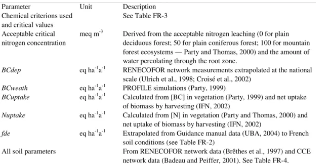
Empirical critical loads of nutrient nitrogen
Method
The determination of empirical critical loads of nitrogen for French ecosystems was based on the method described in chapter 5.2 of the Mapping Manual (UBA, 2004). The values given in table 5.1 of the Mapping Manual, were adapted to the French terrestrial ecosystems (Party et al., 2001) based on: (1) the information available on the potential vegetation and the land use for each ecosystem and, (2) the adaptation rules given in table 5.2 of UBA (2004) using temperature, frost period and base cation availability estimated by expert judgement. The subsequent empirical critical loads are given in Table FR-5.
Table FR-5. Empirical critical loads, in eq ha-1a-1, derived for the French ecosystems (adapted from Party et al., 2001). K: calcareous ecosystem; A: acidic ecosystem; Out Cors.: outside Corsica; Per.+Bord.: Perigord and Bordeaux regions;SW+Nantes: South-West and Nantes regions.
Land use Potential vegetation
Coastal dune Grassland meadow Upland Forest
Coastal dunes and heathlands 1786
Swamps, bogs and wet heathlands 1786 714 714
Quercus robur dominated woodlands 1214 714
Quercus-Carpinus or Ulmus woodlands
with Quercus petraea 1214 1214 500 857
Quercus petraea and Q. pubescens
woodlands 1429 1429 1214
Per. + Bord.: 1214
Quercus petraea, Q. robur or pubescens and
Q. pyrenaica woodlands 1214 SW + Nantes: 714
Mixed Fagus-Quercus and Fagus
woodlands 1214 1214 500 1071
K: 1789 Corsica: 1071
Quercus pubescens woodlands A: 714 Out Cors.: 1429
K: 1789 K: 1789 Corsica: 1071
Quercus ilex woodlands A: 714 A: 714 Out Cors.: 1429
Corsica: 1071
Quercus suber woodlands 714 Out Cors.: 1429
Pinus halepensis and P. nigra laricio
Page 142 of 201 CCE Progress Report 2007 Land use
Potential vegetation
Coastal dune Grassland meadow Upland Forest
Pinus pinaster woodlands 714 500
Abies and mixed Abies-Fagus woodlands 714 714 857
Picea woodlands 714 714
Pinus sylvestris woodlands 714 500
Pinus uncinata and P. cembra woodlands 500 500
Larix woodlands 714 714
Alpine and subalpine grasslands 500
Data Sources
The French ecosystem classification and map was updated in 2003 for calculation and mapping of the critical loads of acidity and nutrient nitrogen (Probst et al., 2003; Moncoulon et al., 2004). The map of potential vegetation was synthesised for the French territory by Party (1999) from various vegetation maps (Dupias and Rey, 1985; Houzard, 1986; Ozenda and Lucas, 1987). Land use was derived from the map of forested and grassland areas in de Monza (1989) as well as the Digital Elevation Model GTOPO30 (USGS, 1996).
Results
The most sensitive areas to nitrogen deposition are located in the Landes (SW), the eastern part of the Paris basin, the eastern part of the Massif Central as well as in the Alps. Empirical critical loads of nitrogen are higher than critical loads for nutrient nitrogen determined with the Steady State Mass Balance (SSMB) model (Probst et al., 2005). Consequently, the sensitivity of the ecosystems is lower when derived from the empirical method. Comparatively to the SSMB model, most of the ecosystems shifted to a higher critical load class with the empirical method (+ 1 class for 49 % of the ecosystems and + 2 classes for 35 % of the ecosystems).
References
Badeau V, Peiffer M (2001) Base des données écologiques des placettes françaises du Réseau Européen de suivi des dommages forestiers (réseau 16 x 1- km). Premier inventaire : juillet 1993 – Octobre 1994 Deuxième inventaire : mai à août 1999. Département Santé des Forêts Antenne Spécialisée. 17pp
Brêthes A, Ulrich E (1998) RENECOFOR : Caractéristiques pédologiques des 102 peuplements du réseau. Office National des Forêts, Département des Recherches Techniques, 573 pp
Croisé L, Ulrich E, Duplat P, Jaquet O (2005) Two independant methods for mapping bulk deposition in France. Atmospheric Environment, 39: 3923−3941
Dupias G, Rey P (1985) Document pour un zonage des régions phyto-écologiques. CNRS, Centre d’écologie des ressources renouvelables. Toulouse. 39 pp + maps
Houzard G (1989) Les forêts primitives de France. In de Monza J.-P. (éd.), Le grand atlas de la France rurale. INRA et SCEES, pp. 348−349 Inventaire Forestier National (2002) Synthèse par département. http://www.ifn.fr/pages/index-fr.html.
Moncoulon D, Probst A, Party J-P (2004) Critical loads of acidity: importance of weathering, atmospheric deposition and vegetation uptake for ecosystem sensitivity determination. C.R. Geoscience, 336: 1417−1426
Monza (de) J-P (ed.) Le grand atlas de la France rurale. INRA et SCEES
Ozenda P, Lucas MJ (1987) Esquisse d’une carte de la végétation potentielle de la France à 1/1 500 000. Documents de Cartographie Ecologique, XXX :49–80
Party J-P (1999) Acidification des sols et des eaux de surface des écosystèmes forestiers français : facteurs, mécanismes et tendances. Taux d’altération sur petits bassins versants silicatés. Application au calcul des charges critiques d’acidité. Thèse de Doctorat, Université Louis Pasteur de Strasbourg. 233 pp
Party J-P, Thomas A-L (2000) Cartographie de la végétation et charges critiques azotées pour la France. Rapport ADEME définitif (marché n°99 62 020)
Party J-P, Probst A, Thomas A-L, Dambrine É (2001) Critical loads for nutrient nitrogen: calculations and mapping by empirical method for France [in French]. Pollution Atmosphérique. 172: 531–544
Posch M, Reinds GJ (2003) VSD – User Manual of the Very Simple Dynamic soil acidification model. Coordination Centre for Effects, Bilthoven, The Netherlands
Probst A, Moncoulon D, Party J-.P (2003) French National Focal Center report. In: M Posch, J-P Hettelingh, J Slootweg, RJ Downing (eds), Modelling and Mapping of Critical Treshold in Europe, Status Report 2003, Coordination Center for Effects, RIVM, Bilthoven, pp. 73−80
Probst A, Moncoulon D, Party J-P (2005) French National Focal Center report. In: M Posch, , J Slootweg, J-P Hettelingh (eds), European Critical Loads and Dynamic MOdelling, Status Report 2005, Coordination Center for Effects, RIVM, Bilthoven, pp. 109−115 UBA (2004) Manual on methodologies and criteria for modelling and mapping critical loads & levels and air pollution effects, risks and
trends. Umweltbundesamt Texte 52/04, Berlin www.icpmapping.org
Ulrich E, Lanier M, Combes D (1998) RENECOFOR — Dépôts atmosphériques, concentrations dans les brouillards et dans les solutions de sol (sous-réseau CATAENAT). Rapport scientifique sur les années 1993 à 1996. Office National des Forêts, Département des Recherches Techniques, ISBN 2-84207-134-4, 135p