An approach to avoid traffic congestion using
VANET
Hamza TOULNI, Benayad NSIRI
GREENTIC, LIAD, Faculty of Sciences Hassan IIUniversity Casablanca Casablanca, Morocco
[email protected]; [email protected]
Mohammed BOULMALF, Mohammed
BAKHOUYA, Tayeb SADIKI
International University of Rabat Sala El Jadida, Morocco [email protected], [email protected]
[email protected] Abstract—Roads’ overload remains a major challenge
although they are constantly expanded in order to increase their capacity and improve their efficiency. This tends to cause many problems: environmentally, economically and socially. The advancement of urban traffic management systems, construction and expansion of roads are solutions to address this problem and improve the performance of the road circulation, but these solutions are very expensive and also require more space for the development and permanent maintenance. An alternative would be to use the new technologies in the field of communication for sending traffic information such as treacherous road conditions and accident sites by communicating, for a more efficient use of existing infrastructure. In this paper, we present a new approach based on VANETs, which can help drivers have a better trip, by finding the optimal path to reduce travel time and fuel consumption. This approach aims to avoid congestion and queues in a more efficient and optimal use of existing road infrastructure by analyzing the useful and reliable traffic information collected in real time.
Keywords— Vehicular Ad-hoc Networks; SUMO; Dijkstra’s algorithm.
I. INTRODUCTION
Transportation plays an important role in economic and social development and can be a powerful catalyst for growth. However, the tremendous number of vehicles exceeding the capacity of roads produces several problems, particularly in terms of road safety, and waste of time and pollution. One of the most significant problems is congestion, and this represents a major handicap for the road transport system. Congestion on the road network is the condition in which the capacity of the infrastructure is insufficient to regulate the flow due to the increased number of users causing a global slowdown in road traffic. This phenomenon is characterized by the deterioration of the quality of service, waste of time, stress problems for users, reduced productivity, increased energy consumption and increased pollution. However, land transportation is the most used means of transportation, which explains the exponential increase in the number of vehicles each year, especially in urban areas, which makes the road infrastructure and the methods of traffic management inappropriate. Construction and expansion of roads, traffic and access managing roundabouts
are solutions to address this problem of traffic congestion and improve the performance of the circulation system, but these solutions are very expensive and also require more space for the development and permanent maintenance. An alternative would be to use the new technologies in the field of communication for a more efficient use of existing infrastructure. This alternative is important to address the problems of traffic Intelligent Transportation Systems (ITS). ITS have emerged as an effective way to improve circulation, allow uses less energy in traveling less distance to reach the desired position with a gain of time and money, while respecting nature, but unfortunately this is not always the case because the congestion is caused by accidents, construction and road repair, inappropriate parking , bad weather conditions, drivers’ behavior, etc.. Having this information will not only reduce the travel time but also avoid congestion, reduce fuel consumption and therefore reduce the amount of greenhouse gas emissions, and improve road safety [1]. One of the effective ways possible to have this information in real time are Vehicular Ad-hoc NETworks (VANETs), they have the ability to collect useful and reliable traffic data for optimal use of road infrastructure, they allow also to improve road safety, and to have access to the Internet for less stress for drivers. In this paper, we present a new approach based on VANETs, which aims to avoid congestion and queues in a more efficient and optimal use of existing road infrastructure by analyzing the data collected in real time.
The rest of this paper is organized as follows: Section II gives a state of the art work of some systems and similar applications of this approach. Section III presents the reasons to choose VANET and Dijkstra’s algorithm. Section IV we present in detail our approach. Section V presents the simulation results. Finally, Section VI gives the conclusions of this work.
II. STATEOFTHEART
In recent years, intelligent transportation systems have made a significant growth, due to the great benefits that can be provided by this technology; these systems are designed to improve road safety, comfort, driving assistance and entertainment. The first offered solutions to help the traffic flow and enhance driving devices are satellite navigation and
2014 Fifth International Conference on Next Generation Networks and Services (NGNS) May 28-30, 2014, Casablanca, Morocco
location services such as GPS [2], these devices provide practice step by step, contact information and a visual representation of current position, and provide the shortest path, which allows the use of less energy in traveling less distance to reach the desired position with a gain of time and money. Some of these devices also allow you to download in real time using a cellular network, the latest information on traffic conditions.
This allows using the fastest way based on traffic state to avoid congestion. But the performance of some applications of location based traffic services can fail sometimes due to disadvantages such as the inability to use especially in urban areas with tall buildings, where the satellite signals may be blocked, leading to possible errors in the data collected. Another strategy to reduce congestion is to optimize traffic signals [3] deployed at intersections by analyzing the data collected in real time traffic. The goal of this optimization is to minimize waiting times in an intersection and increase the number of vehicles crossing the intersection. Then you have to synchronize the lights different intersections to improve traffic in all directions. However, synchronization influence on all intersections of the road network, so a perfect synchronization of traffic lights for traffic flow in a road leads to frequent stops and expectations in other roads. For this, the researchers have proposed to provide roads with strong demand for special events or temporary changes such as the closure of roads due to construction or other, resulting inadequacy of this strategy. Our main objective in this work is to develop a new approach that help drivers have a better trip, avoiding queues and congestion, the optimal use of road infrastructure to reduce travel time and fuel consumption.
III. THE REASON TO CHOOSE VANET AND DIJKSTRA’S ALGORITHM
In our approach, we will use the VANET to obtain relevant information in real time on the road, and after that, we will establish a graph by analyzing the information collected, and at the end we determine the optimal path through the Dijkstra’s algorithm.
A. Why use VANET?
VANETs are based on mobile ad hoc networks, which are designed to provide communication between vehicles and it play a crucial role in providing applications and innovative services [4, 5, 6] in the sectors of road transport.
VANET uses specialized short range communications (DSRC) [7] to broadcast messages at high speed in several directions [8] because its latency is low, but the cover of these solutions is very limited. To overcome this problem, researchers have proposed V2V communication [9], so that vehicles can further communicate with road side unit (RSU), and VANET will therefore not require a significant investment for implementation. In addition to high speed connectivity at lower cost, VANETs can be fitted with several solution and localization techniques [10] vehicles with high accuracy, or with a relative location [11, 12] or even a global location [13, 14].
Fig. 1. Finding the optimal path.
B. Why use Dijkstra’s algorithm?
The problem of the shortest paths has received massive attention from researchers due to its applications in several areas including logistics and transportation, this problem is one of the classic problems of graph theory. The algorithms for this problem have been studied for a long time and they are still in progress [15]. One of the most commonly used algorithms is Dijkstra’s algorithm [16], because of the simplicity of its implementation and performance. Dijkstra’s algorithm guarantees to find the shortest possible path never considering the same vertex twice, and he does not need precalculation, it can be applied to dynamic graphs [17], for that several models are available, probabilistic [18] or non- probability [19]. In our approach, since the map is invariant in time, and only the weights of the edges that changes regularly, we use a model similar to the non-probabilistic model with Dijkstra’s algorithm.
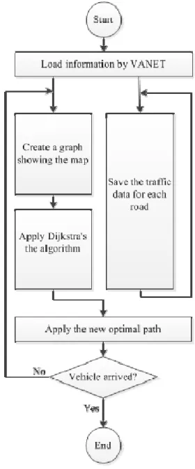
IV. OUR APPROACH
The most recent navigation devices can provide the optimal path based on distance, but when there is an incident blocking traffic, the road no longer considered optimal becomes perhaps the longest path , so the distance is not the only criteria that should be taken into account, but further information on the path must be taken as: the maximum speed to be used in each part of the trip, capacity of the road and the number of vehicles that are in the moment the vehicle must take this route and the number of crossroads and traffic lights for the quickest way possible.
It is in this context that our approach aims to find the optimal path any time, avoiding queues and congestion, and helps improve traffic flow and road safety. This approach is divided into two main parts that run in parallel, the first part is the data storage and the second is the analysis and calculation of data. The first part is to collect and record the movement of all vehicles in the road, we only record Id roads and the date and the change for each vehicle. The second part is performed in two phases:
• Phase 1 is to create a graph showing the map where the edges match to roads, peaks at the intersections of roads, and the weights of the edges in time to travel. In addition to the map of the other necessary information such as information about the traffic, the maximum speed in each segment and the speed of the vehicle in question and the data recorded in the first part.
• Phase 2 is to apply Dijkstra’s algorithm to generate a graph to determine the optimal road from the current vehicle position to the destination point. The storage process: In reality, most vehicles do not support the VANET networks, and we would still have old models in operation, for this reason, we introduce the storage process that aims to save the vehicles’ movements in log files, each file is related to a road, whenever a new vehicle access a road we save the id of the road it’s coming from, the date and the time of access, we can also use a database instead of the log files.
Fig. 2. Map for the simulation scenario.
The history of vehicles’ circulation will help us predict the movement of the vehicles that do not support the VANET during calculations. This history will help us to predict the movement of vehicles which do not support VANET networks in the calculation. The process of analysis and calculates :It’s the main process of our approach, its objective is to present the road network in a form of graph, and deduct its adjacency matrix where the summits are intersections and the size of stopping duration to travel the road, these durations change depending on traffic.
PredictNbrVeh this recursively function to the estimated number of vehicle given a road, it takes two inputs drive the id parameter and the time after which the vehicle arrives at the road, in a first step, we calculate the difference between the entry time and the travel time of the road, if it is negative given the number of vehicles available in the road. If we determine the probability of transition to the road according to historical records indicating the date and time, and also determines the expected number of vehicles for each adjacent road with the same function using the difference already calculated as length entry, and then the sum of the product of the probability times we calculate the number of vehicles for all adjacent road.
TravelTimeCalc This function allows the estimated travel time of a given road, it takes two drives the id parameter and the time when the vehicle arrives at the road; it makes a call to PredictNbrVeh function to determine the number of vehicle under the given time, and then uses the relationship Davidson’s [20] “(1),” to calculate the travel time.
t = t0(1 + 0.25rf [z + (z2 + (8JAx)/rf )0.5]) (1)
TABLE I. NOTATIONANDMEANINGFORPARAMETER EQUATION
Notation Meaning
T travel time
t0 minimum travel time
JA a delay parameter and the errors of estimation q demand, calculated by the real time data according to the historical data Q capacity
x q / Q = degree of saturation
z = x - 1
rf ratio of flow period to minimum travel time
From these functions we can estimate the travel time of each route in the map, this time represents the weights of the edges of the graph.
Now we can easily deduce the adjacency matrix of the graph, then it is applied to Dijkstra’s algorithm to determine the optimal route from the current vehicle position to the destination point. As long as the vehicle has not arrived at its destination, it brought to light travel time of road map, then again it calculates each time the vehicle arrives at the end of a road.
V. SIMULATION
A. The Simulation platform
In this research we need a global control of the environment simulation, for this platform proposed is Simulation of Urban Mobility (SUMO). SUMO has the ability to run as a server to provide dynamic simulation Traffic Control Interface (TraCI) [21] that uses the TCP protocol, which allows the change of scenario when running.
B. Simulation scenario
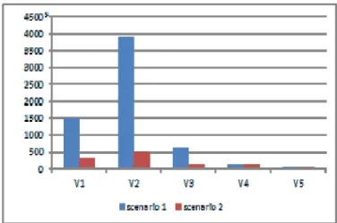
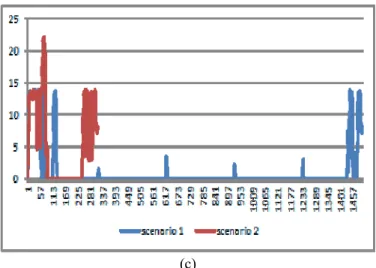
To test the effectiveness of our approach, we consider a real map “Fig. 2” and 70000 vehicles to get a huge amount of traffic, with 2 hours as duration of the simulation. We randomly selected five vehicles in different stages of simulation and different places in the map. Two scenarios are considered in this simulation, in scenario 1 each vehicle identify the shortest path to go to its destination from point of starting, on the other side in scenario 2 each vehicle uses our approach to find an optimal path. For both scenarios, the same vehicles are used with the same points of departure and arrival for each vehicle. During the execution of the two scenarios we collect location, speed and quantity of greenhouse gas released for each vehicle.
C. Results
The results illustrated in “Fig. 3” shows that, the distance traveled by the vehicles V1, V2 and V3 in the scenario 2 is longer than the distance traveled in scenario1, except for vehicles V4 and V5that they have the same distance in both scenarios. However, “Fig. 4” shows that the time required by the vehicles V1, V2 and V3 in the scenario 2 for traveling is lower than the time required in scenario 1, except for vehicles V4 and V5.
Fig. 3. Total distance in Meters for both scenarios.
Fig. 4. Total time in Second for both scenarios.
In fact, if traffic is less important this does not cause congestion, the optimal path considered by our approach is the shortest path, and in the opposite case where the traffic is more important the optimal path considered by our approach is the fastest path even if the distance traveled is longer.
(a)
(c)
Fig. 5. Change of speed in time for the vehicles V1 (a), V2 (b) and V3(c).
Fig. 6. The fuel consumption in ml.
Fig. 7. CO2 emission in g.
“Fig. 5,”which illustrates the change of the speed with respect to time for the vehicles V1 (a), V2 (b) and V3(c) in the both scenarios, We note that the vehicles remained without moving many times and for long periods in scenario 1, unlike in scenario 2 which explains the reduction of travel time in scenario 2. The minimum travel time in scenario 2 also allows for savings in fuel consumption “Fig. 6,” and reduces the amount of greenhouse gas emissions “Fig. 7”. Our results
show a profit of nearly 50% and more reduction in fuel consumption and a gain of more than 70% of the travel time for vehicles in scenario 2 compared to scenario 1 more huge reduction in greenhouse gas. The more road traffic increases, the more solutions exist to improve traffic flow becomes inadequate, but using our approach helps to avoid congestion and consume less energy. Thus, this approach has many advantages in the economic, environmental, social and even the long waiting time at which the driver stress.
VI. CONCLUSION
This paper addresses the problem of optimal path in road networks, where we developed a new approach using the information provided in real time using the VANET technology. The simulation results confirm the effectiveness of this approach; it reduces the travel time in case of congestion, and therefore helps to improve traffic flow and road safety. In the future, we aim the development and validation of our technology by comparing the results with data from different field.
REFERENCES
[1] Ferrari, G., Busanelli, S., Lotti, N., Kaplan, Y., ”Cross-Network Informa- tion Dissemination in VANETs”, 11th International Conference on ITS Telecommunications, pp. 351-356, 2011
[2] Yanying Li; McDonald, M., ”Link travel time estimation using single GPS equipped probe vehicle,” Intelligent Transportation Systems, 2002. Proceedings. The IEEE 5th International Conference, pp.932,937, 2002. [3] Barba, C.T.; Mateos, M.A.; Soto, P.R.; Mezher, A.M.; Igartua, M.A.,
”Smart city for VANETs using warning messages, traffic statistics and intelligent traffic lights,” Intelligent Vehicles Symposium (IV), 2012 IEEE, vol., no., pp.902,907, 3-7 June 2012
[4] J Kargl F., ”Vehicular Communications and VANETs,” Talks 23rd Chaos Communication Congress, 2006.
[5] Mahlknecht S. and Madani S., ”On Architecture of Low Power Wireless Sensor Networks for Container Tracking and Monitoring Applications,” in Proceedings of 5th IEEE International Conference Industrial Informatics, 2007,pp. 353-358.
[6] Barba, C.T. Mateos, M.A. ; Soto, P.R. ; Mezher, A.M. ; Igartua, M.A.” Smart city for VANETs using warning messages, traffic statistics and in- telligent traffic lights” in Conference Publications on Intelligent Vehicles Symposium (IV), IEEE, 2012, pp. 902 - 907.
[7] Yu, Fan F. and Biswas, S. A Self-Organizing MAC Protocol for DSRC based Vehicular Ad Hoc Networks, ICDCS Workshops 2007.
[8] W. Whyte, ”Safe at Any Speed: Dedicated Short Range Communications (DSRC) and On-road Safety and Security,” RSA Conference 2005.
[9] S. Eichler et al., ”Strategies for context-adaptive message dissemination in vehicular ad hoc networks”, in Proceedings of the 2nd International Work- shop on Vehicle-to-Vehicle Communications (V2VCOM), July 2006.
[10] R.Parker and S.Valaee, ”Vehicle Localization in Vehicular Networks ”, Vehicular Technology Conference, 2006. VTC-2006 fall. IEEE 64th, pp. 1-5.
[11] A.Benslimane, ”Localization in vehicular Ad-hoc networks”, Proceedings of the 2005 Systems Communications (ICW’05).
[12] A.Boukerche, H.A.B.F.Oliveira and E.F.Nakamura, ”Vehicular Ad Hoc Networks: A New Challenge for Localization-Based Systems”. Computer Communications, Vol. 31, No. 12. (30 July 2008), pp. 2838-2849.
[13] B. Hofmann-Wellenho, H. Lichtenegger, J. Collins, Global Positioning System: Theory and Practice, 4th ed., Springer-Verlag, 1997.
[14] E.D. Kaplan, Understanding GPS: Principles and Applications, Artech House, 1996.
[15] G. Gallo and S. Pallottino. Shortest Paths Algorithms. Annals of Oper.Res., 13:3-79, 1988
[16] Bolin Ding, Jeffrey Xu Yu, and Lu Qin.Finding time-dependent short- est paths over large graphs. In Proceedingsof the 11th international conference on Extending database technology: Advances in database technology, EDBT’08, pages 205-216, New York, NY, USA, 2008. ACM.
[17] F. Kuhn and R. Oshman. Dynamic networks: models and algorithms. SIGACT News, 2011, 42(1):82-96 (2011).
[18] P.B Mirchandani et H. Soroush. Optimal paths in probabilistic networks. A case with temporary preferences . Computers & Operations Research, 1985, 12:365 - 383 (1985).
[19] H. Mao, Pathfinding Algorithms for Mutating Graphs. Computer Sys- tems Lab 2007-2008 (2008).
[20] Akelik , Rahmi. Travel Time Functions for Transport Planning Purposes: Davidson’s Function, its Time-Dependent Form and an Alternative Travel Time Function. In Australian Road Research, 21(3), September 1991, pp 49-59.
[21] A. Wegener, M. Piorkowski, M. Raya, H. Hellbrck, S. Fischer, and J.- P.Hubaux, ”TraCI: An Interface for Coupling Road Traf?c and Network Simulators”, in 11th Communications and Networking Simulation Sym- posium.).