HAL Id: hal-03024346
https://hal.archives-ouvertes.fr/hal-03024346
Submitted on 25 Nov 2020HAL is a multi-disciplinary open access
archive for the deposit and dissemination of sci-entific research documents, whether they are pub-lished or not. The documents may come from teaching and research institutions in France or abroad, or from public or private research centers.
L’archive ouverte pluridisciplinaire HAL, est destinée au dépôt et à la diffusion de documents scientifiques de niveau recherche, publiés ou non, émanant des établissements d’enseignement et de recherche français ou étrangers, des laboratoires publics ou privés.
Distributed under a Creative Commons Attribution - NonCommercial - NoDerivatives| 4.0 International License
First results on the city planning of Cyrrhus (Syria)
Jeanine Abdul Massih, Christophe Benech, Mathilde Gelin
To cite this version:
Jeanine Abdul Massih, Christophe Benech, Mathilde Gelin. First results on the city planning of Cyrrhus (Syria). Archeosciences, revue d’Archéométrie, G.M.P.C.A./Presses universitaires de Rennes, 2009, Mémoire du sol, espace des hommes, Supplément (33), pp.201-203. �10.4000/archeo-sciences.1584�. �hal-03024346�
ArcheoSciences
Revue d'archéométrie
33 (suppl.) | 2009
Mémoire du sol, espace des hommes
First results on the city planning of Cyrrhus
(Syria)
Jeanine Abdul Massih, Christophe Benech and Mathilde Gelin
Electronic version URL: http://journals.openedition.org/archeosciences/1584 DOI: 10.4000/archeosciences.1584 ISBN: 978-2-7535-1599-4 ISSN: 2104-3728 Publisher
Presses universitaires de Rennes
Printed version
Date of publication: 30 October 2009 Number of pages: 201-203
ISBN: 978-2-7535-0943-6 ISSN: 1960-1360
Electronic reference
Jeanine Abdul Massih, Christophe Benech and Mathilde Gelin, « First results on the city planning of Cyrrhus (Syria) », ArcheoSciences [Online], 33 (suppl.) | 2009, Online since 30 October 2011, connection on 01 May 2019. URL : http://journals.openedition.org/archeosciences/1584 ; DOI : 10.4000/ archeosciences.1584
ArcheoSciences, revue d’archéométrie, suppl. 33, 2009, p. 201-203
h e site of Cyrrhus is located in the Afrin valley (North Syria) at the crossing of the roads between Antioch and inner Syria. h e layout of the lower town of Cyrrhus is established on a rectangular grid fanning out from the Main Street (Fig. 1). h is Hippodamian plan in the pure Hellenistic tradition seems to be more or less respected in the Roman and Byzantine periods. h e grid pattern is centred on a colonnaded main street running north/south across the entire city. However, during the Roman period, the town planning is articulated east-west and north-south by the implementation of a new axis for traffi c. h e streets lead to the major monuments of the site. h e 7m wide north-south Street paved with basalt serves the Roman theatre located
on the slope of the citadel and the Roman military camp at the western edge of the town. In the Byzantine period the grid is respected in regard to its alignment but the buildings encroach on the width of the streets, particularly on the por-tico of the main road. h e Islamic settlement seems to have changed little in the city’s layout; but some new discoveries show a completely diff erent organisation and orientation unfortunately unknown till today.
h e Lebanese-Syrian Archaeological Mission of Cyrrhus has developed a research project based on the study of the town planning along with the system of fortifi cation. h is work on the defenses is being carried out by Shaker Shbib of the DGAMS of Syria and co-director of the excavation team.
First results on the city planning of Cyrrhus (Syria)
Jeanine Abdul Massih *, Christophe Benech ** and Mathilde Gelin ***
Keywords: Magnetic survey, Excavations, classical period, city planning, Syria.
* Lebanese University, Beirut.
** UMR 5133 Archeorient, Maison de l’Orient et de la Méditerranée. *** UMR 7041 Arscan, Maison René Ginouves.
Figure 1: Satellite view (Google Earth) from the site of Cyrrhus with the main monuments indicated.
202 Jeanine ABDUL MASSIH, Christophe BENECH, Mathilde GELIN
ArcheoSciences, revue d’archéométrie, suppl. 33, 2009, p. 201-203 h e study of Cyrrhus through geophysical survey is being developed in collaboration with the Project PROGECESA (Geophysical survey and study of ancient urban centers of Syria), fi nanced by the French National Agency of Research. h is research concerns the lower city of Cyrrhus which until now has remained almost wholly unknown.
F
IRSTRESULTS1) Excavations
h e Lebanese-Syrian Archaeological Mission concentrated its fi rst investigation of the southern fortifi cation on: the citadel, the walls, the towers and the main entrance. h e choice of the southern wall was made in parallel with the study of the town planning in this part of the city. h e main street is represented by a straight line coming from the nor-thern entrance toward the south. At a point after the theater this street deviates to the south-west and passes through the southern entrance. h is variation on the main axe was ana-lyzed and explained by new discoveries on the position of the fi rst fortifi cation on the slope of the acropolis.
h e fi rst fortifi cation (Fig. 2)
A work program has been established on the citadel of Cyrrhus under the supervision of M. Gelin. Work began in
2007 on the south part of the fortress fortifi cations, with the aim of establishing its complete chronology. A wall built with huge polygonal stones is visible under the medieval for-tifi cations, which represents the fi rst state of occupation.
Inside the fortress, work has been carried out on the façade of a medieval tower and is continuing. h e results show that this tower is built on top of a more ancient one, as in the case of the fi rst wall mentioned above. Its construction materials and techniques lead us to think that it was proba-bly built by Greeks. Only further work will confi rm or not these results. Several later occupations have been revealed, with domestic structures belonging to the medieval period. It is however surprising that neither Roman nor Byzantine levels has been found.
East of the citadel, on the slope leading to the lower city, we cleaned and revealed the continuation of the so-called Greek rampart, with two towers and the curtain-wall. Unfortunately, the soil had mostly been removed down to bedrock and no stratigraphy subsists, but the wall is lin-ked to the fi rst rampart. It has a diff erent line from the later wall (more oriented to the north) and this discovery is very important for the city’s history: it means that the early city, maybe in Greek times, was smaller than the Roman, Byzantine and Medieval ones.
For the next campaign, work will be concentrated on the two towers sector, with the aim of reaching foundation levels in order to date their construction. Other soundings will be opened on the east wall, to establish if the existing citadel had the same plan in antiquity.
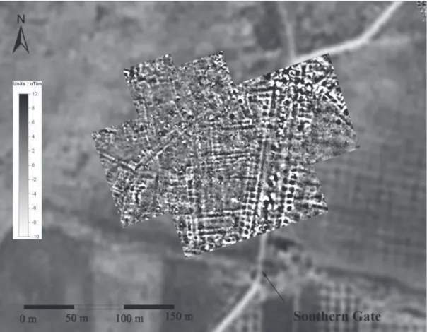
2) Magnetic survey (Fig. 3)
h e magnetic survey was carried with a Cesium gradi-ometer using 0.1s acquisition data and 1 m space between profi les. h e survey began in the southern part of the site, where the main north-south street changes direction to reach the southern gate. h e fi rst results revealed interest-ing information about the evolution of the city’s layout. h e main street is about 19m wide and is bordered by small square rooms (6 m each side), which can be identifi ed with-out doubt as shops. h e change of direction of the main street cut through the original plan of the city. h is original orientation took into account buildings on the western side of the main street, where one of them clearly shows the ground plan of a church. We fi nd also the same orientation in the buildings of the northern part of the site and also in
Figure 2: Ike view from the excavation of the fi rst fortifi cation of Cyrrhus. To the south, in the left part of the picture, we can follow the layout of the byzantine fortifi cation.
First results on the city planning of Cyrrhus (Syria) 203
ArcheoSciences, revue d’archéométrie, suppl. 33, 2009, p. 201-203 the northern part of the main street. On the eastern side,
all the constructions seem to have the same orientation as the main street. In the western part of the magnetic map, we have also a high density of buildings but without specifi c orientation. At present it is diffi cult to make a statement about the chronology of this organization in regard to the buildings along the western side of the street. None of these parts seems to override the other. h ey could be contempo-raneous and the diff erence of orientation might be due to a diff erent organization of the city planning on the slopes of the hill. Moreover, the plan of the buildings is totally diff er-ent and in the north western corner of the magnetic map, they seem to be surrounded by a wall.
C
ONCLUSIONIn further study the limit of the fi rst Hellenistic estab-lishment needs to be identifi ed through archaeological and geophysical survey in order to complete the alignment of the fi rst rampart and to locate the previous southern main entrance of the city. Study of this issue will be completed by the geophysical results on the survey of the entire area between the current limits of the site and the original align-ment. h is study will expand the research and assist our
comprehension of the evolution of the town plan along with the expansion of the city.
Références
FREZOULS, E., 1954-1955. Recherches historiques et archéologi-ques sur la ville de Cyrrhus, AAAS, IV-V: 89-128.
FREZOULS, E., 1977. Cyrrhus et la Cyrrhestique jusqu’à la fi n du Haut-Empire, ANRW, II: 164-197.
ABDUL MASSIH, J. 2006-2007. Évaluation de l’état général du site archéologique de Cyrrhus – Nebi Houri, Annales Archéologiques de Syrie, under press.
ABDUL MASSIH, J. Notes préliminaires sur la fortifi cation polygo-nale et les mosaïques de la maison romaine de Cyrrhus (Nebi Houri), Syria, under press.
Figure 3: Magnetic survey on both sides of the main street, just to the North of the southern gate.