HAL Id: hal-01562556
https://hal-amu.archives-ouvertes.fr/hal-01562556
Submitted on 15 Jul 2017HAL is a multi-disciplinary open access archive for the deposit and dissemination of sci-entific research documents, whether they are pub-lished or not. The documents may come from teaching and research institutions in France or abroad, or from public or private research centers.
L’archive ouverte pluridisciplinaire HAL, est destinée au dépôt et à la diffusion de documents scientifiques de niveau recherche, publiés ou non, émanant des établissements d’enseignement et de recherche français ou étrangers, des laboratoires publics ou privés.
Forms and deposits of the continental quaternary of the
Saharan margin of Eastern Maghreb (tentative
synthesis)
Jean-Louis Ballais, Hédi Ben Ouezdou
To cite this version:
Jean-Louis Ballais, Hédi Ben Ouezdou. Forms and deposits of the continental quaternary of the Saharan margin of Eastern Maghreb (tentative synthesis). Journal of African Earth Sciences, Elsevier, 1991, 12 (1/2), pp.209 - 216. �10.1016/0899-5362(91)90070-F�. �hal-01562556�
Journal of African Earth Sciences, VoL 12, No. 1/2, pp. 209-216, 1991. 0899-5362/91 $3.00 + 0.00
Printed in Thailand @ 1991 Pergamon Press pie
Forms and deposits of the Continental Quaternary of
the Saharan margin of Eastern Maghreb (Tentative Synthesis)
J. L. BALLAIS* and H. BEN OUEZDOU**
*Facult6 des Sciences Humaines et Sociales, 94, Boulevard 9 Avril 1938, 1007 Tunis, Tunisie **Centre des Sciences de la Terre, LN.R.S.T., B.P. 95, 2050 Hammam-Lif, Tunisie
Abstract- The Saharan margin of Eastern Maghreb extends from Auras in the West to the Gulf of Gab~s in the East. The Plio-Quaternary boundary is very complex in the West where it is characterized by the persistence of Tertiary sedimentation with the development of ablation forms, presence of crusts and the form ation of a lacustrine system. This is followed by the development of accumulation forms during the Middle Pleistocene and mostly during the Upper Pleistocene to Holocene with contemporaneous diminution in the gra~ulometry of the deposits.
The evolution of gyperetes at the expense of calcretes crust suffered a partial reverse during the Middle Pleistocene. At this time a lacustrine phase settled down in the Algero-Tunisian Chotts (sebkhas).
The end of the Middle-Pleistocene corresim~ded with a major climatic break with the disappearance of the calcrctes. By the end of the Upper Pleistocene, the gylx~etes attained their maximum development and latter disappeared during the Holocene.
R~sum~ - Ce brian provisoire s'appuie sur les connaissa~ces acquises depuis 25 ans dans les Auras, les Nemencha, la r6gion des grands Chotts alg6ro-tunisiens, le Dahar et la plaine c&ih'e de Gab~s. I1 permet de mettre en 6vidence roriginalit6 de la charni~re Plioc~ne-Quatemaire et le rSle des variations climatiques dans revolution quatemaire.
La eharni~re Plioc~ne-Quatemaire monlre,d'une part, lapersistance de certaines earact~ristiques tertiaires (continuit~ de la s&iimentation : d6tritique darts la plaine c.&i/~re, laeustre darts la r6gion des grands Chotts) et, d'autre part, 1'apparition de nouveiles caract6ristiques (formation de crofites gypseuses dans lar6gion des grands ehotts et formation de crofites calcaires ailleurs). Les formes sont plus vari6es h rOuest (pseudo-rafia, glacis, coul6es boueuses) qu'~ rEst (p6diment ou glacis). Une r6duction du nombre des niveaux s'observe 6galement de rOuest (3 niveaux) ;~ rEst (1 seul niveau).
A u Pl~istoe~e moyen, les formes d'accumulation (glacis d'accumulation dans les Aur/~s, terrasse dans le Dahar et dans laplaine c6ti~:re) commencent ~se substituer aux formes d'ablation (glacis d'ablationcouvert). AuPl6istochae sup6rieur- Holoc~e, c.eRe tendance se g6n6ralise (terrasse, c6ne alluvial et 6pandage) ~ rexception de la r6gion des grands Chotts tunisiens.
D e l a m ~ m e facron, la granulom6trie des d6p6ts, grossih'c au Pl6istoc~neinf6rieur et moyen, devient fine au Pl6istoc~ne sup6fieur (avec un gradient W-E) et ~ dominante fine h l'Holoc~ne.
Enfm, r6volution g6ochimique montre le d6veloppement progressif, au Pl6istoc.~ne moyen et surtout au Pl6istoc~e sup~eur, des crofites gypsenses 0imit6es aux conf'ms des grands Chotts au Pl6istoc~ne inf6rieur) aux ddpens des crofites calcaires; en effet, si les deux types de crofites altement encore au Pl~istoc~e moyen, les crofites gypsenses dominent totaleanent an Pl6istoc~ne sup6rieur (sauf dam les Matmata) avant de disparaitre au cours de rHoloc~ne.
Cette 6volution met en 6vidence rexistence d'une coupure climatique fondamentale/, la fm du Pl6istoc~ne moyen et d'autres moins importantes t la fin du Pl6istoc~e inf6rieur et ~ la fin du Pl6istoc~ne sup6rieur. L'absence d'une phase lacustre au P16istoc~e moyen posait donc un probl~me majeur et se trouvait en contradiction avec les earact6ristiques elimatiques de cette p&iode. Des datations radiom6u'iques (T/U) ont pennis r6cemment de conf'Lrmer rexistence d'une telle phase.
INTRODUCTION
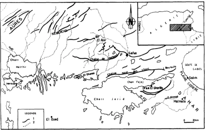
Since the last 25 years, knowledge of the continental Quaternary of the Saharan margin of Eastern Maghreb has increased considerably. It is n o w p o s s i b l e t o a t t e m p t a r e v i e w o f t h e Q u a t e r n a r y g e o l o g y o f t h e r e g i o n e x t e n d i n g f r o m A u r e s i n t h e w e s t t o t h e G u l f o f G a b 6 s i n t h e e a s t ( s e e Fig. 1). T h e a r e a c a n b e s u b d i v i d e d i n t o s i x d i s t i n c t m o r p h o t e c t o n i c z o n e s a s f o l l o w s : A u r 6 s , N e m e n c h a , T u n i s i a n s a l i n e l a k e s o r C h o t t s , D a h a r , M a t m a t a b a s i n s a n d t h e c o a s t a l p l a i n o f G a b 6 s . T h i s s t u d y , r e v e a l s t h e s i m i l a r i t i e s i n t h e s e z o n e s t h a t a r e p r o b a b l y d u e t o Q u a t e r n a r y c l i m a t i c v a r i a t i o n s a s w e l l a s d i f f e r e n c e s i n o t h e r r e g i o n a l p a r a m e t e r s . F R O M T H E S O U T H E R N P I E D M O N T OF T H E ~ T O T H E GULF O F GABES: REGIONAL P R E S E N T A T I O N O F T H E C O N T I N E N T A L Q U A T E R N A R Y T h e S o u t h e r n P i e d m o n t o f t h e A u r ~ ( B a l l a i s ,
1984}
T h e P l i o c e n e - Q u a t e r n a r y b o u n d a r y - T h e e n d o f t h e P l i o c e n e s e d i m e n t a t i o n ( 1 0 0 0 m t o t a l t h i c k - 209210 J.L. BALL~S and H. Bss O ~ u
I
.."
.
' : ,-'",
,'J
' k - - - ~ ~ . , a, . .
~ ... 'I
/ "
~ ! ~ ~c
' '. ."'i ,, .." .." .." "~ ) .... i , ~. "s,,f,-,, L /I
,.. ...
, - "
i
</¢"o,, 7 , - , . . ~ ~"
/
~
,
,
...
~
.-.,~--
~
, j
I ~
'~a
(_,
< " - , x ~ ~ ,
. . o . ~ ~
.Fig. I. I~catlon map. I - main reliefs, 2 - limit of morphotectonic zones. Fig. I. Carte de IocalisaUon. 1 - reliefs principaux; 2 - limite de zone morphotectonique. ness) is c h a r a c t e r i z e d by 200 to 300 m of
c o n g l o m e r a t e s ( G u i r a u d , 1973) p r o b a b l y c o n t e m p o r a n e o u s with t h e first l a c u s t r i n e p h a s e in the Melrhir a n d M e r o u a n e Chotts. As well as t h e preceeding deposits, t h e y are affected by the tectono-orogenic p h a s e of the Lower Quaternary.
A c o n v e x - s h a p e d pseudo-rafia was locally deposited later with a length of 1 km, width of 20 m at the u p s t r e a m e n d a n d a few m e t e r s at the d o w n s t r e a m end. It c o n s i s t s of blocks t h a t c a n attain several cubic meters, often r o u n d , loose, covered by a calcrete. By a dip of 6% it t r u n c a t e s the C e n o m a n i a n limestone w h i c h have b e e n vertically redressed, over 300 m above the beds of the p r e s e n t d a y wadis.
T h e L o w e r P l e i s t o c e n e - The Lower Pleistocene is c h a r a c t e r i z e d by alternation of glacis a n d m u d flows. The oldest Glacis (Glacis, VI) y o u n g e r t h a n the LowerAcheulian (Ballais, 1984), is r e p r e s e n t e d by some s c a t t e r e d m o u n d s with several m e t e r s of cover consisting of large blocks close to the relief. This covered ablation glacis-fan c h a n g e s e a s t w a r d into a c c u m u l a t i o n glacis or fan, The characteristic calcacrete at t h e top in t h e west is .llaitially covered by gypsiferous e n c r u s t i n g a n d t h e n by a gypcrete w h i c h r e m a i n s exclusive s o u t h of Nemencha. Mud flows of several kilometers long a n d several t e n s of m e t e r s t h i c k c o n t a i n i n g large blocks of several cubic m e t e r s a n d with a calcrete at the top are sub- s e q u e n t l y emplaced. The s e c o n d glacis (Level V) is
well represented. It is generally a n ablation glacis- fan covered by blocks a n d pebbles s o m e t i m e s strongly consolidated b y a c a l c a r e o u s cement. A s e c o n d generation of m u d flows is e m p l a c e d with the s a m e c h a r a c t e r i s t i c s a s the first.
T h e M i d d l e P l e i s t o c e n e - It is d u r i n g t h i s period t h a t the glacis attained their m a x i m u m extension. The m u d flows d i s s a p e a r as the t e r r a c e s develop a n d the eolian s e d i m e n t s a c c u m u l a t e in t h e west. The glacis IV is well developed a n d is often a n a c c u m u l a t i o n glacis-fan (of a b o u t I0 m of large stones, bedded, alternating with silt, s a n d s a n d gravels). It g r a d e s laterally into "6pandages" or cover ablation glacis. It is replaced b y t h e last series of m u d flows still several kilometers in length b u t only 10 to 20 m t h i c k with no terminal crust.
The pre Middle Paleolithic Glacis {III) is less developed. It is a n a c c u m u l a t i o n glacis-fan or a glacis - terrace a n d occasionally a covered ablation glacis-fan. It is only covered by a gypcrete in the west a n d p a s s e s laterally into alluvial fans or a very restricted terrace. Finally, a l a c u s t r l a n p h a s e could be p r o d u c e d in the Melrhir a n d M e r o u a n e Chotts {Ballais et a£, 1985}.
T h e U p p e r P l e i S t o c e n e - This was a period of limited deposition a n d geomorphologic forms. Glacis II, t h e last glacis-terrace of s a m e age, often c o n s t i t u t e s t h e principal terrace. It generally p o s s e s s e s a gypcrete. D o w n s t r e a m it g r a d e s into a m u c h finner fan. A s e c o n d l a c u s t r i a n p h a s e is t h u s
Forms and deposits on the Continen~l Quaternary of the Saharan margins (Tentative Synthesis) 211 developed in t h e Melrhir a n d M e r o u a n e C h o t t s (Coque et Gachelin, 1975). T h e H o l o c e n e - This is a period of c o m p l e x d e p o s i t i o n (Ballais, 1986) characterized b y t h e s e t t i n g u p of n e w eolian a c c u m u l a t i o n s t h r o u g h - o u t t h e Lower S a h a r a (Ballais et BenA~,ouz, 1987). It is followed b y t h e a c c u m u l a t i o n of a terrace (often s u b d i v i d e d into 2) several m e t e r s h i g h or s t o n y f a n s w h i c h d o w n s t r e a m grade into large extensive a n d m o r e f u n c t i o n a l playas.
THE REGION OF THE LARGE TUNISIAN CHOTT8 (Coque, 1 9 6 2 ) T h e P l i o c e n e - Q u a t e r n a r y b o u n d a r y T h e Tertiary e n d e d w i t h t h e deposition of t h e C o n t i n e n t a l T e r m i n a l C o m p l e x c o n s i s t i n g of seve- ral h u n d r e d s of m e t e r s of s a n d s t o n e s , clays a n d c o n g l o m e r a t e s . T h r e e regional t y p e s c a n be d i s t i n g u i s h e d . At t h e top, gypsiferous d e p o s i t s c o n t a i n i n g Cerastoderma glaucum r e p r e s e n t - ing a first "lagoonal" p h a s e d a t e d as Lower Vfllafranchian from m a m m a l i a n f a u n a at Ain Brimba. T h e s e d e p o s i t s were often deformed d u r i n g a Villafranchian tectono-orogenic p h a s e .
T h e Middle P l e i s t o c e n e
It is c h a r a c t e r i z e d by t h e d e v e l o p m e n t of glacis 4 a n d 3. Glacis 4 is limited to a few m o u n d s in front of J e b e l Tebaga a n d is covered by gypcrete. The ablation Glacis 3 (0,50 m to 6 m of h e t e r o m e t r i c cover c o n s i s t i n g of t h e m o s t r o u n d e d a n d t h e less fiat p e b b l e s in all t h e 4 glacis), c o n s i t s m a i n l y of m o u n d s or interfluves covered by a gypcrete. It g r a d e s into a terrace n e a r t h e wadis. The cover revealed a n A c h e u l i a n i n d u s t r y .
T h e Upper P l e i s t o c e n e
Glacis 2 is generally t h e m o s t developed. The cover (0,50 m to 5 m) c o n s i s t s of fewer r o u n d e d a n d relatively m o r e fiat s t o n e s t h a n t h e precedent. It p a s s e s laterally into a terrace. A M o u s t e r i a n i n d u s t r y c h a r a c t e r i z e s t h e b a s e of t h e cover while a bladelet i n d u s t r y is p r e s e n t t o w a r d s t h e top.
A s e c o n d "lagoonal" p h a s e with Cerastoderma
g / a u c u m is c o n t e m p o r a n e o u s with t h e develop- m e n t of t h i s glacis. T h e gypcrete w h i c h later seals t h e cover, equally fossilizes t h e d u n a l a c c u m u l - a t i o n s s o u t h of t h e Chotts.
H o l o c e n e
Glacis i developed d u r i n g t h e Holocene. It is well developed at t h e foot of t h e h i g h c h a i n s a n d a r o u n d t h e b a s e level b u t is also a simple terrace along t h e wadis. Its c o a r s e - g r a i n e d cover (0,50 m to 2 m) does n o t c o n t a i n a gypcrete b u t locally silty g y p s e o u s s a n d s of I to 2 m t h i c k n e s s .
Cartographic s t u d i e s a n d r e c e n t geomorphologic o b s e r v a t i o n s h a s led to n e w d a t a o n t h i s region. In fact a r o u n d t h e p i e d m o n t s o u t h of J e b e l C h e b k e t Bouloufa (North c h a i n of t h e Chotts), t h e cover of t h e h i g h e s t ablation glacis (Glacis 3) is characteriz- ed by a c a l c a r e o u s c e m e n t with a calcrete (Abbes et
a/., 1986). A c o n g l o m e r a t e with c a l c a r e o u s c e m e n t (capping glacis 3?) t r u n c a t e t h e Lower C r e t a c e o u s s a n d s t o n e s of Draa el Ghorifa ( S o u t h e r n b a n k of FeJaJ Chott). Elsewhere, in c e r t a i n s e c t o r s like t h e s o u t h e r n p i e d m o n t of t h e Meflaoui Chain, five Q u a t e r n a r y levels c a n b e recognized. (Ben O u e z d o u et Zargouni, 1988). A low t e r r a c e a n d a glacis, w i t h coarse g r a i n e d m a t e r i a l s w i t h o u t e n c r u s t i n g s u c c e e d t w o G l a c i s - f a n s w i t h gypcretes. Finally, a c o n g l o m e r a t e w i t h calcareous- s a n d s t o n e c e m e n t w i t h Levallois i n d u s t r y c o n s t i t u t e s t h e oldest level.
THE WESTERN MARGIN OF DAHAR (Coque, 1 9 6 2 )
T h e Lower P l e i s t o c e n e
D u r i n g t h e Lower Pleistocene a p e d i m e n t developed o n t h e S e n o n i a n l i m e s t o n e s with a slight dip t o w a r d s t h e west. A z o n e d f r a g m e n t e d calcrete (reg) overlies t h e c a l c a r e o u s s u b s t r a t u m . Near t h e axes of t h e m a i n wadis, t h e Lower Pleistocene c o n s i s t s of a very c o n s o l i d a t e d c o n g l o m e r a t e w i t h a n g u l a r c a l c a r e o u s s t o n e s (Coque, 1962).
T h e Middle P l e i s t o c e n e
The Middle Pleistocene c o n s i s t s of a terrace a b o u t 5 m h i g h with c o a r s e - g r a i n e d deposits c o n t a i n i n g pebbles 10 to 2 0 c m long c e m e n t e d into a conglomerate. S o m e of t h e p e b b l e s are f r a g m e n t s ofcalcrete of Lower Pleistocene age (Coque, 1962).
Recent o b s e r v a t i o n s (Ballais, 1984: BaUais etal.,
1988) d i s t i n g u i s h e d t h e following:
- a terrace with a c o m p l e x c o m p o s i U o n consist- ing o f silts s o m e t i m e s g y p s e o u s a n d rare conglomeratic l e n s e s with two calcrete s e p a r a t e d by a gypcrete. T h i s u n i t y is p r o b a b l y Middle Pleistocene.
- a terrace, a b o u t 4 m h i g h c o n s i s t i n g of l e n s e s of c o n g l o m e r a t e s or c o a r s e - g r a i n e d f r i a b l e deposits, a l t e r n a t i n g with silts a n d c a l c a r e o u s concretions. This u n i t y is p r o b a b l y U p p e r Pleistocene.
- a terrace with t h i c k d e p o s i t s of a b o u t 2 m consist- ing of c o a r s e - g r a i n e d l e n s e s a n d s a n d y w i t h silty lenses. This u n i t y is p r o b a b l y of Holocene age.
THE MATMATA BASINS ( C o u d ~ - G a u s s e n e t al., 1 9 8 4 )
Peridesertic loess d e p o s i t s c o n s i s t i n g of very fine s a n d s a n d silts m a i n l y q u a r t z e o u s are deposited
212 J. L. BALLAIS and H. BEN OUEZDOU w i t h i n t h e b a s i n s o n t h e M a t m a t a Plateau. T h e s e
loess with a t h i c k n e s s t h a t c a n a t t a i n 20 m , c o n t a i n 4 to 5 altered layers. T h i s r e p r e s e n t s BCa a c c u m u l a t i o n c a r b o n a t e horizon w i t h c a l c a r e o u s c o n c r e t i o n s of different facies (nodules, friable c r u s t , m o r e or less c o n t i n u o u s t h i n flagstone). A n u p p e r Pleistocene age is a t t r i b u t e d to t h i s loess. In fact, t h e m o s t r e c e n t t h r e e paleosoils levels have b e e n d a t e d b y 14Cas b e t w e e n 10 0 0 0 to 3 2 0 0 0 y e a r s B.P. T h e m o s t a n c i e n t two levels are s i t u a t e d time-wise above t h e 14C limit. T o w a r d s t h e w e s t e r n a n d e a s t e r n b o r d e r s of t h e M a t m a t a Plateau, t h e loess d i m i n i s h in t h i c k n e s s a n d b e c o m e m o r e g y p s e o u s . U n c o n f o r m i t i e s re- p r e s e n t e d b y erosional glacis replace t h e calcretes a n d t h e paleosofls t o w a r d s t h e e a s t w h e r e a s to t h e west g y p c r e t e s progressively appear.
However, r e c e n t s t u d i e s in a n d a r o u n d t h e M a t m a t a P l a t e a u ( K a m m o u n et B e n Ouezdou, 1984; B e n O u e z d o u et Zouari, 1986; Zouari etal., 1986, B e n O u e z d o u , 1988) do n o t entirely confirm t h e s e s t r a t l g r a p h i c d a t i n g s particularly as the 14C d a t i n g s w e r e o b t a i n e d f r o m c a l c a r e o u s c o n c r e t i o n s w h i c h are extremely unreliable. Indeed, t h e n o d u l e s silts a n d calcretes are al- ways s u p e r p o s e d at t h e top of t h e h i g h terrace w i t h o u t ever fit t o g e t h e r w i t h it. This h i g h terrace d a t e s to final A c h e u l i a n (Ben Ouezdou, 1986). The silts a n d s a n d s were probably deposited be- fore t h e d o w n c u t t i n g of t h e h i g h terrace, to- w a r d s t h e e n d of t h e Middle Pleistocene. The m a i n depositional p h a s e of t h e silts a n d s a n d s w a s probably at t h e e n d of t h e Middle Pleistocene. This d o e s n o t exclude t h e possibility of silt depo- sition d u r i n g t h e U p p e r Pleistocene (Ben Ouezdou, 1986).
M GABES COASTAL PLAIN
(Ben Ouezdou, 1984,
1986,
1987) The Pliocene-Quaternary boundaryThe P l i o c e n e - Q u a t e r n a r y b o u n d a r y in t h e G ab~s coastal plain d o e s n o t display a n y u n c o n f o r m i t y . The c o n t i n u i t y of detritic c o n t i n e n t a l s e d i m e n t - ation {clays, s a n d s a n d conglomerates) r e s u l t s in a g r a d u a l i n d i s t i n c t p a s s a g e b e t w e e n t h e Tertiary a n d t h e Q u a t e r n a r y .
The Lower P l e i s t o c e n e
A n ablation glacis c u t d o w n into g y p s e o u s clays, s a n d s a n d c o n g l o m e r a t e s is probably of Lower Pleistocene age. Strongly d i s s e c t e d b y t h e hydro- g r a p h i c n e t w o r k a n d r e d u c e d to s c a t t e r e d m o u n d s a n d interfluvial p a t c h e s , t h i s glacis is covered by a c o n g l o m e r a t e w i t h c a l c a r e o u s c e m e n t of a b o u t 0.5 m t h i c k n e s s . A s a l m o n calcrete overlies t h e conglomerate. It is relatively well p r e s e r v e d in t h e p i e d m o n t zone b u t b e c o m e s m o r e a n d m o r e
b r o k e n u p t o w a r d s t h e c o a s t w h e r e it is replaced by a m o r e r e c e n t gypcrete.
The Middle P l e i s t o c e n e
A h i g h terrace lies w i t h i n t h e Lower Pleistocene glacis a n d c o r r e s p o n d s to a d e p o s i t of 5 m m a x i m u m t h i c k n e s s , v e r y h e t e r o g e n o u s c o n s i s t i n g of blocks, p e b b l e s a n d fine to coarse s a n d s . Semi-fiat a n d r o u n d e d p e b b l e s are pre- d o m i n a n t w i t h i n t h i s d e p o s i t originating from t h e generally c l a c a r e o u s a n d dolomitic t e r r a i n of t h e M a t m a t a Plateau. The red a n d beige silt l e n s e s with c a l c a r e o u s c o n c r e t i o n s of vary- ing degree of d e v e l o p m e n t are i n t e r c a l a t e d w i t h i n t h e c o a r s e r - g r a i n e d deposits. The degree of consolidation i n c r e a s e s u p w a r d s . At t h e t o p of t h e deposits, a calcrete developed in layers or a s slabs or m o r e frequently a s conglomerate. In places, silts also c o n t a i n a calcrete a n d s y s t e m - atically s u p e r p o s e d c o a r s e - g r a i n e d d e p o s i t s a n d t h e cover of t h e Lower Pleistocene glacis. The Middle Pleistocene d a t i n g of t h i s c o m p l e x is d u e t o final A c h e u l i a n i n d u s t r y a n d t h e existence of M o u s t e r i a n i n d u s t r y at t h e b a s e of t h e m i d d l e terrace (see below).
The Upper P l e i s t o c e n e and the Holocene
A m i d d l e terrace or a n a c c u m u l a t i o n glacis is enclosed w i t h i n t h e two m o s t a n c i e n t levels a n d c o n s i s t s of d e p o s i t s of variable t h i c k n e s s (3 to 15 m) m a d e u p of silty m a t e r i a l a n d gyps- e o u s clays. C o a r s e - g r a i n e d l e n s e s (rudites) are i n t e r c a l a t e d w i t h i n t h i s fine series. Occasional- ly, a n erosional level often m a r k e d by gypcrete pebbles h e l p s to d i s t i n g u i s h two m e m b e r s with- in t h i s complex. At t h e top, a c r u s t with variable t h i c k n e s s develops (ranging from several centi- m e t e r s to 1,5 m). The visible b a s e of t h e depo- sits d a t e d a s 28 0 0 0 y e a r s B.P. (NC) revealed a M o u s t e r i a n i n d u s t r y (Gobert,1962; Page, 1983; F o n t e s et aL, 1983). T o w a r d s t h e top, a lithic i n d u s t r y w a s a s c r i b e d to I b ~ r o m a u r u s i a n (Gobert, 1962). Recently it h a s b e e n ascribed to a s o u t h e r n C a p s i a n facies (Ben O u e z d o u et al., 1986). The d e p o s i t i o n w a s c o m p l e t e d a b o u t 8 0 0 0 y e a r s B.P. (Lower Holocene) (Fontes e t aL, 1983).
A lower terrace, w h i c h h a s b e e n r e d u c e d to a b e n c h u p s t r e a m , generally i n c r e a s e s in import- ance d o w n s t r e a m . The d e p o s i t s w h i c h are a b o u t 2 m in t h i c k n e s s b e c o m e increasingly coarser-grain- ed longitudinally. It c o n s i s t s of pebbles, gravels a n d occasional blocks at t h e exit of t h e m o u n t a i n s y s t e m b e c o m i n g increasingly fine g r a i n e d (sandy) d o w n s t r e a m . T h e d e p o s i t i o n w h i c h is d a t e d at t h e b a s e as 5 1 9 5 + 105 y e a r s B.P. ( S t e i n m a n u n d Bartels, 1982), c o n t i n u e s d u r i n g t h e historic period as evident b y t h e discovery of f r a g m e n t s of p o t t e r y at t h e t o p of t h e terrace.
Forms and deposits on the Continental Quaternary of the Saharan margins (Tentative Synthesis) PROBABLE CORRELATIONS
General Characteristics (see Table}
The pliocene-Quatemary boundary is character- Izcd by its complexity {Riser, 1979}. It still presents the characteristic of the Tertiary era particularly with regard to the continuation of the sediment- ation at the Continental Terminal summit. T w o facies can be distlnguishcd: a fluviatile detrltic facies in the Gab6s coastal plain and the Aur6s- N e m e n c h a piedmont; as well as a lacustrian facies in the centre of the basin of large Algcro-Tunlsian saline lakes. O n the other hand, characteristics typical of the Q u a t e m a r y era are present, particularly with regards to thc crusts which correspond to a characteristic regional repartition or distribution. The gypcrete at the top of the Continental Tcrminal is centered around the Tunisian salt lakes, N e m e n c h a {Cabot, 1971}, and the eastern part of the( southc)-n picdmont of
213 Aur6s. O n t h e contrary, at t h e s a m e period, t h e calcretes covered all t h e o t h e r s u r f a c e s studied. Finally, t h e t y p e s a n d n u m b e r of f o r m s b e c o m e progressively simple from w e s t to e a s t (see Table}. It is strongly probable t h a t t h i s simplification is related to regional f e a t u r e s d u e to t e c t o n i s m , as well a s to altitude a n d energy of relief.
The Middle Pleistocene is generally characterized by t h e d e v e l o p m e n t of a c c u m u l a t i o n f o r m s a n d gypcretes. The a c c u m u l a t i o n glacis, "6pandages", fans {Aur6s, Nemencha) a n d terraces (Dahar, Gab6s coastal plain} g r a d u a l l y replaced ablation forms (covered ablation glacis} w h i c h are located in t h e region of t h e great T u n i s i a n saline lakes. The gypcretes s p r e a d globally at t h e e x p e n s e of t h e calcretes in a r a t h e r c o m p l i c a t e d m a n n e r . This is obvious t o w a r d t h e w e s t w h e r e t h e r e is a t e n d e n c y to replace calcretes on t h e s o u t h A u r a s i a n pied- m o n t . O n t h e contrary, o n t h e w e s t - e r n flank of Dahar, a gypcrete is i n t e r c a l a t e d b e t w e e n two Synthetic t a b l e of c o n t i n e n t a l Q u a t e r n a r y f o r m s a n d d e p o s i t s o f t h e S a h a r a n m a r g i n
of e a s t e r n M a g h r e b .
Tableau synth6tique des formes et d6pfts du Quatemalre continental du Maghreb oriental.
Periods and Age in years BP Holocene 10000 30 0007 Upper Pleistocene 90000 150 000 Middle Pleistocene 700 000? Lower Pleistocene
Piedmont south Piedmont south Region of the great Dahar Ma~nata basins Gulf of Gab~s of Attr~s of Nemencha Tunisian Chotts Coastal Plain
Terrace alluvial fan, coarse Glacis 1, lower Terrace, fine terrace, alluvial deposits with
fan and fine "6pandage"
G y p c r e t e G y p c r e t e L a c u s t r i n e h a s e Terrace, f'me and coarse deposits
Gypcrete L A C U S T R Cover of ablation glacis, coarse deposits F L E X U Calcrctc and gypcrcte, accumulation glacis, coarse deposits. C a l c r e t e , cover of ablation glacis coarse deposits with sandy-calcareous malrix. I N E P H A S E Cover of ablation glacis coarse deposits R A T I O N Gypcrete, cover of ablation glacis coarse deposits. Gypcrete, cover of ablation glacis, coarse deposits with c a l c a r e o u s - gypseous matrix. Gypcrete, cover of ablation glacis, coarse deposits with calcareous- gypseous matrix C a l e r e t e , c o v e r of ablation glacis, coarse, deposits with sandy- calcareous matrix. Pseudo-rafia Cover of ablation glacis, coarse deposit with sandy-
gypseous matrix Gypcrete and calcrete
C o v e r : of ablation glacis, conglomerates with calcareous cement Gypcrete cover of ablation glacis Major tectonic phase north of the Chotts Conglomerates, silts with intercalated gypcretes coarse beds. Terrace, coarse to fine deposits Terrace, coarse and fine deposits with intercalated gypcretes and calcretes Calcrete, pediment and conglomeratic terrace
Terrace, coarse to fine deposits Gypcrete, terrace
accumulation Silts with
calcareous glacis, gypseous concretions fine deposit with
intercalated gypcretes M a j o r t e c t o n i c phase Silts with c a l c a r e o u s concretions Terrace, coarse deposits with calcrete Rejuvenated faults Calcrete, cover of ablation glacis, conglomerate Gypseous clays, conglomerate and sand Pliocene L a c u s t r i a n p h a s e
214
calcretes a n d o n t h e s o u t h e r n p i e d m o n t of t h e FeJaJ saline lake, a calcrete, o n t h e o t h e r h a n d , c o n s o l i d a t e s t h e cover of t h e glacis 3. However, in t h e Gab~s c o a s t a l plain a n d t h e M a t m a t a t r o u g h s , t h e r e is also t h e f o r m a t i o n of calcretes.
T h e U p p e r m o s t P l e i s t o c e n e - H o l o c e n e is c h a r a c t e r i z e d b y t h e p r e d o m i n a n c e o f a c c u m u l a t i o n f o r m s (terraces, alluvial fans, "~pandages', etc..) t h r o u g h o u t t h e flank of t h e S a h a r a w i t h t h e exception of t h e region a r o u n d t h e large T u n i s i a n saline lakes. O n e form only c a n be d i s t i n g u i s h e d d u r i n g t h e U p p e r Pleistocene in a g e n e r a l s e n s e . T h i s is a terrace. Similarly, t h e gypcretes totally d o m i n a t e d u r i n g t h e U p p e r Pleistocene w i t h t h e probable exception of t h e M a t m a t a t r o u g h s w h i c h are characterized by silts with c a l c a r e o u s c o n c r e t i o n s . T h e s e gypcretes d i s a p p e a r e d d u r i n g t h e Lower Holocene. The g r a n u l o m e t r y of t h e U p p e r Pleistocene deposits b e c o m e s finer following a w e s t - e a s t g r a d i e n t a n d p e r s i s t s d u r i n g t h e Holocene with t h e exception of terrace I of A u r a s a n d glacis I of t h e large T u n i s i a n saline lakes. Finally, a l a c u s t r i a n p h a s e t h a t c a n be a t t r i b u t e d to t h e U p p e r Pleistocene develops within t h e b a s i n of t h e Algero-Tunisian large saline lakes.
D I S C U S S I O N
D u r i n g t h e Q u a t e r n a r y , t h e p a s s a g e is generally from levelling f o r m s to a c c u m u l a t i o n forms. In- deed, covered ablation glacis or less frequently, p e d i m e n t s are replaced by terraces, alluvial f a n s a n d "6pandages".
A prlor~ this type of s u b s t i t u t i o n could only be t h e effect of s h o r t e n i n g of t h e evolution time after t h e Lower Pleistocene. This d o e s n o t m e a n m u c h as it is n o t possible to c o n c l u d e t h a t t h e g e n e s i s of t h e a c c u m u l a t i o n f o r m s is m o r e rapid t h a n t h a t of t h e erosional forms. In addition, it is n o t also possible to c o n c l u d e t h a t this g e n e s i s is a neces- sary stage in t h e d e v e l o p m e n t of t h e erosional forms.
However, even if t h i s s u b s t i t u t i o n is general, it is n o t c o n c o m i t a n t everywhere. This m o r p h o l o g i c b r e a k e overlaps in time into t h r e e p h a s e s in t h e six regions. In effect, for t h e entire Gab~s coastal p l a i n - b a s i n s of M a t m a t a - D a h a r , t h e b r e a k is s i t u a t e d b e t w e e n t h e Lower Pleistocene a n d t h e Middle Pleistocene. O n t h e o t h e r h a n d , for t h e s o u t h e r n p i e d m o n t of A u r a s a n d N e m e n c h a , t h e p a s s a g e from erosional to a c c u m u l a t i o n forms o c c u r r e d at t h e e n d of t h e Middle Pleistocene - w h e r e a s in t h e region of t h e g r e a t T u n i s i a n Chotts, this t o o k place at t h e e n d of t h e U p p e r Pleistocene. This h i g h l i g h t s t h e originality of t h e great T u n i s l a n Chotts. T h i s difference c o u l d be explained by a difference in t h e tectonic evolution of t h e t h r e e
J. L. B ~ s and H. BEN Otw.zr~ou
units. T h e erosional f o r m s followed m a j o r tectonic p h a s e s in t h e p i e d m o n t s o u t h of A u r a s a n d N e m e n c h a as well a s in t h e region of t h e great T u n i s i a n Chotts. T h e overlap in t i m e b e t w e e n t h e D a h a r - b a s i n s of M a t m a t a - e o a s t a l p l a i n of Gab~s o n t h e one h a n d a n d t h e p i e d m o n t s o u t h of A u r a s a n d N e m e n c h a as well a s t h e region of t h e great T u n i s i a n C h o t t s o n t h e o t h e r h a n d , m a y be explained by t h e age of different geological struc- tures. As t h e ftrst g r o u p Is relatively old, t h e s e c o n d g r o u p is relatively y o u n g . Within t h e s e c o n d group, t h e overlap in t h e b r e a k b e t w e e n t h e great T u n i s i a n C h o t t s a n d t h e p i e d m o n t s o u t h of A u r a s a n d N e m e n c h a m a y be explained by t h e overlap in t h e b e g i n n i n g of t h e m a j o r tectonic p h a s e (see Table}. F r o m t h e sedimentologic p o i n t of view, t h e d e p o s i t s are generally c o a r s e - g r a i n e d (rudltes) d u r i n g t h e Middle Pleistocene. O n t h e contrary, t h e y b e c o m e d o m i n a n t l y fine (lutites or arenites < 500 ]am) d u r i n g t h e U p p e r Pleistocene a n d t h e Holocene w i t h t h e exception of t h e great T u n i s i a n Chotts. This also c o n s t i t u t e s a n additional evidence in s u p p o r t of t h e originality of t h e region of great T u n i s i a n Chotts. It also confirms t h e existence of a m a j o r climatic b r e a k at the e n d of t h e Middle Pleistocene. T h e Middle Pleistocene is characterized by a climate w h i c h is m o r e h u m i d a n d aggressive t h a n t h a t of t h e U p p e r Pleistocene. The Middle Pleistocene w a s a l a c u s t r i a n p h a s e w h i c h p r e v a i l e d t h r o u g h o u t t h e Algero-Tunisian C h o t t s s y s t e m (Ballais e t al., 1985). T / U d a t i n g s (Fontes e t al., 1987) confirms this a n d p e r m i t t h e identification of a l a c u s t r i a n p h a s e d u r i n g t h e Middle Pleistocene ( 150000 - 9 0 0 0 0 y e a r s B.P.) as in Wadi A s h - s h a t i (Gaven, 1982) a n d as in t h e west of Algeria (Causse
et al., 1988).
F r o m t h e g e o c h e m i c a l p o i n t of view, t h e time range of t h e d i s t r i b u t i o n of t h e two basic types of c r u s t s a n d e n c r u s t i n g s reveal a h i g h degree of complexity a n d evidence of t h e i m p o r t a n c e of regional p a r a m e t e r s . Analysis of t h e d i s t r i b u t i o n in time a n d space of t h e s e two t y p e s of c r u s t s lead to t h e following c o n c l u s i o n s :
- t h e M a t m a t a b a s i n s experienced only one type of c r u s t {calcretes) particularly d u r i n g t h e Middle Pleistocene with t h e possibility of m o v e m e n t s of c a r b o n a t e s d u r i n g U p p e r Pleistocene. This region c o n s t i t u t e s a special case o n t h e scale of t h e s t u d i e d zone b e c a u s e of t h e a b s e n c e of gypcretes.
- In t h e Gabes coastal plain, t h e r e w a s a definite b r e a k b e t w e e n t h e Middle Pleistocene with calcretes a n d t h e U p p e r Pleistocene - Lower Holocene with gypcretes. This c h a n g e m a y be related to a climatic c h a n g e with a t e n d e n c y t o w a r d s aridity. This is b e c a u s e of t h e n e c e s s i t y
Forms and deposits on the Continental Quaternary of the Saharan margins (Tentative Synthesis) 215 for less w a t e r in t h e mobilization of c a l c i u m
sulfate w i t h reference to c a l c i u m carbonate. - D a h a r a n d t h e A u r a s p i e d m o n t experienced only
one type of c r u s t d u r i n g t h e Lower Pleistocene. T h i s is t h e calcrete. D u r i n g t h e Middle Pleistocene, t h e two t y p e s of c r u s t s a l t e r n a t e d w i t h o u t a n y visible break. - B o t h t h e g r e a t T u n i s i a n C h o t t s a n d t h e p i e d m o n t s o u t h of N e m e n c h a are c h a r a c t e r i z e d b y t h e d e v e l o p m e n t of g y p c r e t e s from t h e Lower Pl~istocene to t h e U p p e r Pleistocene w i t h rare a p p a r i U o n of calcretes.
- T h e a l t e r n a t i o n of b o t h types of c r u s t s d u r i n g t h e Middle P l e i s t o c e n e p r o b a b l y c o n f i r m t h e complexity of t h e climatic evolution. If this evolution is c h a r a c t e r i z e d by a general t e n d e n c y t o w a r d s aridity d u r i n g t h e Q u a t e r n a r y w i t h o u t a n y regional c h a n g e in t h e lithology (Coque, 1962; Ballais, 1984; B e n Ouezdou, 1986, 1987), t h e s i t u a t i o n is different d u r i n g t h e Middle Pleistocene w h e n at least one h u m i d f l u c t u a t i o n occasionally reversed t h i s t e n d e n c y . The c r u s t s t u d i e d in t h i s p a p e r c a n n o t be r e g a r d e d a s of p u r e l y pedogenetic origin a n d therefore i n t i m a t e l y related to t h e c h a r a c t e r i s t i c s of t h e s u b s t r a t u m . O n a regional scale, it h a s b e e n well e s t a b l i s h e d in t h e p a s t t h a t m o s t of t h e gypcretes, p a r t i c u l a r l y t h o s e w h i c h directly overlie a n o n - g y p s e o u s s u b t r a t u m (often calcareous) are d u e to fixation by vegetation of d u s t s t a k e n by t h e w i n d from t h e S e b k h a s (great Chotts) (Coque, 1962). D u r i n g t h e Pleistocene, t h e d e v e l o p m e n t of t h e g y p c r e t e s at t h e e x p e n s e of t h e calcretes, o n t h e p i e d m o n t s o u t h of A u r ~ s - N e m e n c h a from east to west, w i t h n o m o d i f i c a t i o n of t h e s u b s t r a t u m a n d t h e h y d r o g r a p h i c network, is a p r o o f t h a t t h e r e is i n c r e a s e in aridity (BaUais, 1985), b e c a u s e gypcretes a d v a n c e d f u r t h e r a n d f u r t h e r from t h e g r e a t Chotts. The c o n t e m p o r a n e o u s a p p e a r a n c e of t h e first Q u a t e r n a r y w i n d d e p o s i t s in t h e Ziban, J u s t to t h e west, confirms this interpretation (Ballais
etal., 1979). O n a local scale (wadi A h m a d i o n t h e
w e s t e r n f l a n k of Dahar), a gypcrete intercalates b e t w e e n two calcretes in t h e Middle Pleistocene terrace at a t i m e w h e n t h e b a s i n is only calcareous. This c r u s t w h i c h r e s u l t s from t h e a c c u m u l a t i o n of g y p s e o u s d u s t s u g g e s t a b r e a k in t h e s u p p l y of dissolved c a l c i u m b i c a r b o n a t e s w h i c h t o o k p a r t in t h e f o r m a t i o n of t h e s u r r o u n d i n g calcretes. The s u b s t i t u t i o n of w a t e r t r a n s p o r t e d d e p o s i t s by w i n d t r a n s p o r t e d d e p o s i t s c o n f i r m s a less h u m i d climate. CONCLUSION
This review a t t e m p t s to c o m p a r e with t h e S a h a r a n M a g h r e b w e s t e r n a n d central m a r g i n regions b a s e d on t h e investigations of C o n r a d
(1969) in t h e Algerian S a h a r a , C o u v r e u r (1978) in l i m e s t o n e s of t h e C e n t r a l High Arias a n d Riser (1978) in t h e J e b e l S a h r h o . It certainly confirms t h e c o n c l u s i o n s of t h e s t u d i e s in t h e e a s t e r n Maghreb. D u r i n g t h e Lower Pleistocene, t h e m o u n t a i n s e c t o r s provided t h e rafias or t h e m a j o r solifluxion flows as well a s t h e glacis or t e r r a c e s with calcretes, w h i l s t a l a c u s t r i a n p h a s e with
Cerastoderma g / a u c u m w a s t a k i n g place in T o u a t
a n d Ahnet. T h e Middle Pleistocene also w i t n e s s e d t h e d e v e l o p m e n t of a c c u m u l a t i o n f o r m s s u c h as t h e conglomeratic t e r r a c e of n o r t h e r n S a h a r a f a n s a n d m o u n t a i n t e r r a c e s with calcretes. F r o m t h e U p p e r Pleistocene, t h e f a n s a n d t e r r a c e s are pre- d o m i n a n t l y detriUc, terrlginous, fluviatile a n d fluvio-eolian d e p o s i t s silt-grained a n d clayey (< 60 pm).
It is also n e c e s s a r y to s t r e s s t h e i m p o r t a n c e of t h e Middle Pleistocene period a n d t h e p a s s a g e to U p p e r Pleistocene in t h e S a h a r a n f l a n k of east- e m Maghreb. In general, t h e e n d of t h e Middle Pleistocene is m a r k e d by f u n d a m e n t a l b r e a k s in morphology, s e d i m e n t o l o g y a n d geochemistry. Morphologic b r e a k is w i t n e s s e d by t h e d i s a p p e a r - ance of t h e big ablation glacis, w h i c h were principally s u c c e e d e d by terraces. The s e d i m e n t o - logic b r e a k is m a r k e d w i t h t h e e n d of t h e exclusive p r e d o m i n a n c e of c o a r s e - g r a i n e d d e p o s i t s (rudites). Finally, t h e g e o c h e m i c a l b r e a k is w i t n e s s e d by t h e a l m o s t c o m p l e t e d i s a p p e a r a n c e ofcalcretes a n d t h e d e v e l o p m e n t ofgypcretes. The Middle Pleistocene is also characterized by t h e complexity of t h e observed t e n d e n c i e s . It is n o w e s t a b l i s h e d t h a t a l a c u s t r i a n p h a s e r e a p p e a r e d at t h e e n d of t h e period. This p h a s e w a s traditionally a t t r i b u t e d to t h e U p p e r Pleistocene (Coque, 1962), a n d s e e m s to be quite generalized t h r o u g h o u t n o r t h e r n S a h a r a from Libya to Erg Chech. The t e n d e n c y of c o n t i n u o u s e x t e n t i o n of t h e gypcretes from Lower Pleistocene w a s d i s t u r b e d by t h e d e v e l o p m e n t of n e w calcretes.
REFERENCES
Abbes, C. et AbdelJaouad, S. avec la collaboration de Ben Ouzdou, H. 1986. Carte g~ologique d' El Hamma au 1 / 100 000 (sud tunisten). Serv. g~ol. Ttmisie. Ballais, J.-L., Marre, A. et Rognon, P. 1979. P~lodes arides du Quatemaire r~cent et d~placement des sables &)Liens dams les Zibans (Alg~rie}. Rev. ~,¢xjr.
phys. et G~L dyn. (2)21, 2, 97-108.
Ballads, J.-L. 1984. Recherches g~'omorphologiques darts les Auras (Alg~rie). A.N.R.T., Lille, France.
Ballads, J.-L. 1985. ZonaUon et aridlflcation au Quatemadre moyen dans l'Aflas saharien alg~rlen oriental. Phys|o-G~t,o 14-15. 125-130.
Ballads, J.-L., Balland, V., Bena~,'louz, M. T. et Coque, R. 1985. Recherches pr~limlnaires sur r~voluUon quaternadre du Bas-Sahara alg~rlen. In: Pour Fernand Jo/y, 29-39, C.E.R.G.C.G., Paris, France.
J. L. BAU~S and H. BEN OUE2DOU 216 Ballais, J.-L. 1986. Variations d u milieu ~ rHoloc/me
dans les Auras (Alg~rie). In: Changements globaux en Afr~ue durant le Quaternaire, Travaux et Doc. ORS- TOM 197, 19-21.
Ballals, J.-L. et Benazzouz, M. T. 1987. S~limentatlon quaternaire lacustre et 6olienne dans le Bas-Sahara alg~rien. 8th I.A.S. Regional Meeting of Sedim., 54-55, Tunis, Tunisie.
Ballals, J.-L., Ben Ouezdou, H., Ghanmt, M. et Regaya, IC 1988. La coupe de l'oued Ahmadi (Dahar, Sud tunisien) : son int~r~t pour la compr6hension de l'~'volution climatique au Pleistocene moyen. Mg~d/t~rrang, e 2, 52-60.
Ben Ouezdou, H. 1984. Stratigraphle des d~p6ts quaternaires continentaux et matins du golfe de
Gab~s. C.R. Ac. Sc. Paris, 299, II, 1351-1354.
Ben Ouezdou, H. 1986. Essai de corr~lation des formations quatemaires continentales et marines dans les alentours du golfe de Gab~s. ~ y n a m l q u e
I(2), 81-95.
Ben Ouezdou, H., Camps, G., Gragueb, A., MahJoub, K. et Zouarl, K. 1986. Sur les d6pSts du Pl6istoc~ne sup~rieur et de ITIoloc~ne de la r~gion des Chotts et de la plaine cStl~re du golfe de Gab~s (Tunisle) et leur place dans la straUgraphie du Quatemaire. C.R.Ac. Sc. Paris, 302, II, 659-664.
Ben Ouezdou, H. et Zouari, H. 1986. Carte gt~ologique de Mareth au 1/100 000. Serv. g6ol. Tunisie.
Ben Ouezdou, H. 1987. Etude morphologlque et stratlgraphique des formations quatemaires des alentours du golfe de Gab~s. Rev. Sc. Terre 5, 1-165. Ben Ouezdou, H. et Zargouni, F. 1988. Nouvelles
donn~-es & propos du Quaternaire et de la tectonique r~cente darts la chaine de Meflaoui (sud-ouest de la Tunlsie}. M~diterran~e 2, 22-26.
Cabot, J. 1971. Recherches morphologiques s u r le pi~mont m~ridional de l'Aur~s. Rev. Georra Dyn. 3, 129-
140.
Causse, C., Conrad, G., Fontes, J.-C., Gasse, F., Gibert, E. et Kasslr, A. 1988. Le demier ,humide, pl~istoc~ne du Sahara nord-occidental daterait de 80- 100 000 ans. C.R. Ac. Sc. Par~s, 308, II, 1459-1464.
Causse, C., Coque, R., Fontes, J.-C., Gasse, F., Ben Ouezdou, H. and Zouari, K. in press. Two high levels of continental waters in southern Tunisia about 90 and
150 ka.
Conrad, G. 1969. L'evolutlon continentale post-hercy- nienne du Sahara algerien (Saoura, Erg Chech-Tane- zrouft, Ahnet-Mouydir). C.N.R.S., Paris, France. Coque, R. 1962. La Tunisie pr~saharienne, ~tude
g~omorphologique. A. Colin, Paris, France.
Coque, R. et Gachelin, C. 1975. Probl~mes g~omorpho- logiques du Bas-Sahara alg~ro-tunisien. In: M~langes oJferts d G. Viers, 161-169, Univ. Toulouse-Le Mirail, France.
Coud/~-Gaussen, G., Le Coustumer, M. N. et Rognon, P. 1984. P a l t ~ o l s d ' ~ e pleistocene sup~rieur darts les loess de Matmata (Sud tunisien). Sc. GeoL 37(4), 359- 386.
Couvreur, G. 1978. Essai s u r l'6volutlon morphologique du Haut Atlas central calcaire (Maroc). A.N.R.T., Lille, France.
Fontes, J.-C., Coque, R., Dever, L., Filly, A. et Mamou, A. 1983. Pal~ohydrologie lsotopique de l'oued Akarlt (Sud tunisien) au P16istoc~ne superieur et & l'Holoc~ne. Paleog., Paleoel., PaleoecoL 43, 41-62.
Fontes, J.-C., Gasse, F., Ben Khelifa, L., Zouart, K., Ben Ouezdou, H., Zaouali, J., Carbonel, P. et Causse, C. 1987. Programme Palhydaf. Etat d'avancement, site I: Ttmisie meridionale. In: S~m. P a / ~ / a c s -Pal~oclimats enAm. lat. etenAfr. (20 000 arts B.P. -Actuel), 1, Bondy, France.
Fontes, J.-C., Gasse, F., Zouari, K., Ben Khelifa, L., Ben Ouezdou, H., Carbonel, P., Causse, C., Thouveny, N., Tucholka, P. and Zaouali, J. 1987. Lacustrine sediments from wadi E1 Akarit and Chott Fejaj (south Tunisia) since 140 000 B.P. In: Symp. Palaeocl. and envlronm, reconst, from lacust, basins, 1, Strasbourg, France.
Gaven, G. 1982. Radiochronologie isotopique. In: Le Shati, lac pleistocene du Fezzan (Libye) (Ed. par Petit-Maire, N.), 44-55, Paris France.
Gobert, E. G. et Howe, B. R. 1952. L'Ib6ro-maurusien de l'oued E1Akarit {Tunisie). In: Actes lI~rne Cong. p a n a f prob., 575-598, Alger, Alg6rie.
Gobert, E. G. 1962. La pr~histoire dans la zone littorale de la Tunisie. Quatemarla IV, 271-307.
Guiraud, R. 1973. Evolution post-trtasique de l'avant- pays de la chaine alpine en Alg~rie d'apr~s l'~tude d u bassin du Hodna et des r~gions voisines. Th~se doct. ~s-Sciences, Nice, France.
Kammoun, Y. et Ben Ouezdou, H. 1984. Le Quatemaire du Golfe de Gab~s, Monts de Matmata et plaine cStl~re (Tunisie orientale). In: lO~me R.A.S.T., 313, Soc. g~ol. France, Paris, France.
Page, W. D. 1983. The geological setting of the archaeological site at oued El Akarit and the palaeo-climatic significance of gypsum softs, southern Tunisia. Serv. g~ol., Tunis, Tunisie.
Riser, J. 1978. Le jbel Sarhro et sa retomb~e saharienne (Sud-Est marocain). Etude g~omorpho- logique. Th~se Doc. ~s-Lettres, Aix-en-Provence, France. • Riser, J. 1979. La periode chami~re entre Plioc~ne et
Quaternaire. Bull Ass. g~ogr, fr. 462, 229-233. Steinmann, S. und Bartels, G. K. 1982. QQartar-
"geomorphologische beobachtungen ans nord und sud Tunisien. Catena 9, 95-108.
Zouarl, H., Kammoun, Y. et Regaya, K. 1986. Carte g~ologique de Matmata au 1 / I 0 0 000 (sud tunisien). Serv. g~ol. Tunisie.