HAL Id: cea-02511873
https://hal-cea.archives-ouvertes.fr/cea-02511873
Submitted on 10 May 2020HAL is a multi-disciplinary open access
archive for the deposit and dissemination of sci-entific research documents, whether they are pub-lished or not. The documents may come from teaching and research institutions in France or abroad, or from public or private research centers.
L’archive ouverte pluridisciplinaire HAL, est destinée au dépôt et à la diffusion de documents scientifiques de niveau recherche, publiés ou non, émanant des établissements d’enseignement et de recherche français ou étrangers, des laboratoires publics ou privés.
southern England
O. Evrard, C. Heitz, M. Liégeois, J. Boardman, Karel Vandaele, A.-V. Auzet,
Bas van Wesemael
To cite this version:
O. Evrard, C. Heitz, M. Liégeois, J. Boardman, Karel Vandaele, et al.. A comparison of management approaches to control muddy floods in central Belgium, northern France and southern England. Land Degradation & Development, 2010, 21 (4), pp.322-335. �10.1002/ldr.1006�. �cea-02511873�
For Peer Review
A comparison of management approaches to control muddy floods in
1
central Belgium, northern France and southern England
2 3
Olivier Evrard
a, b ◊,*, Carine Heitz
c, Marie Liégeois
d, John Boardman
e,
4
Karel Vandaele
f, Anne-Véronique Auzet
c, Bas van Wesemael
a5 6
a
Département de Géographie, Université catholique de Louvain, Place Louis Pasteur 3,
7
B-1348 Louvain-la-Neuve, Belgium
8 b
Laboratoire des Sciences du Climat et de l’Environnement (LSCE/IPSL) – Unité Mixte de
9
Recherche 8212 (CEA, CNRS, UVSQ), 91198-Gif-sur-Yvette Cedex (France)
10
c
Université Louis Pasteur, Strasbourg, France
11 d
ENTPE, Laboratoire RIVES, Rue Maurice Audin, F-69518 Vaulx-en-Velin Cedex, France
12
e
Environmental Change Institute, University of Oxford, South Parks Road,
13
Oxford OX13UB, UK
14
f
Interbestuurlijke samenwerking land en water, Watering van Sint-Truiden,
15
Minderbroedersstraat 16, B-3800 Sint-Truiden, Belgium
16
◊Fonds pour la formation à la Recherche dans l’Industrie et l’Agriculture (F.R.I.A.), Belgium 17
18
Abstract 19
20
Muddy floods, i.e. water flowing from agricultural fields and carrying large quantities of soil, affect 21
routinely numerous municipalities of central Belgium, northern France and southern England. A 22
comparison of flood frequency between different European regions is difficult, because of the lack of a 23
uniform and official database as well as the landscape heterogeneity of administrative entities. Agri-24
Environmental Measures (AEMs; e.g. grass buffer strips) can contribute to the control of muddy 25
floods but their installation is voluntary and depends therefore on farmers’ willingness. Actions to 26
increase awareness and to inform the farmers proved to increase drastically their participation rate in 27
AEM programmes. In all the studied regions, flood prone areas are increasingly taken into account to 28
define land approved for development. Moreover, several schemes for the control of muddy floods 29
have also been proposed at the regional scale. However, there is a spatial mismatch between the scale 30
at which muddy floods are triggered (small catchment scale) and the scale at which public authorities 31
can operate (municipality, grouping of municipalities, delineated flood prone areas, river basin). In 32
future, beside curative measures (e.g. retention ponds and dams), farming techniques preventing runoff 33
and erosion in the field (e.g. conservation tillage) should be encouraged. This could be achieved by the 34
creation of a new AEM. Moreover, guidelines for the location of AEMs could usefully be introduced. 35
Existing flood control schemes should also be systematically carried out by catchment agencies 36
including legal, environmental and financial expertise. These agencies should be set up for local 37
groupings of municipalities and provide them technical assistance to equip the flood prone areas and 38
carry out maintenance of the implemented control measures. 39 40 3 4 5 6 7 8 9 10 11 12 13 14 15 16 17 18 19 20 21 22 23 24 25 26 27 28 29 30 31 32 33 34 35 36 37 38 39 40 41 42 43 44 45 46 47 48 49 50 51 52 53 54 55 56 57 58 59 60
For Peer Review
Key words41
Muddy floods, stakeholders, environmental management, agri-environmental measures, soil 42
erosion, flooding of properties 43
* Corresponding author. E-mail address: olivier.evrard@lsce.ipsl.fr. 44
45
1. Introduction 46
47
In the European loess belt, water flowing from agricultural fields and carrying large 48
quantities of soil as suspended sediment or bedload frequently concentrates and leads to 49
muddy floods in the downstream villages (Boardman et al., 1994; 2006). They are generally 50
triggered on silty and loamy soils which are prone to surface sealing. Central Belgium, 51
northern France and southern England are severely affected by these floods (see e.g. 52
Boardman et al., 2003; Souchère et al., 2003; Evrard et al., 2007a). The main physical 53
processes contributing to muddy floods are runoff generation on crusted soils, the detachment 54
of soil particles and aggregates by rainfall and runoff as well as the sediment transport over 55
long distances by runoff, particularly when the flow concentrates in linear landscape features 56
such as thalwegs, field borders and tramlines. This increases runoff connectivity, flow 57
velocity and peak discharge between cropland and downstream villages or rivers. The 58
occurrence of muddy floods in the different regions of the European loess belt is related to the 59
interaction between rainfall distribution and soil surface conditions including vegetation cover 60
(Auzet et al., 1990; Ludwig et al., 1995; Souchère et al., 1998; Takken et al., 2001; Evrard et 61
al., in press). In Belgium and eastern France, most floods are associated with heavy 62
thunderstorms on fields planted with summer crops (e.g. maize, sugarbeet, potatoes) and 63
occur between May and September (Vandaele and Poesen, 1995; Evrard et al., 2007a). The 64
floods are even more concentrated in eastern France with a peak in May and June (Van Dijk 65
et al., 2005). In southern England on the South Downs as well as in northwestern France 66
(Normandy), they are mainly reported in autumn and winter, associated with fields planted 67
with cereals (Boardman et al., 2003). 68
Beside on-site impacts (e.g. gullying, damage to crops), muddy floods lead to 69
numerous off-site impacts and induce high damage costs (Boardman et al., 2003; Evrard et 70
al., 2007a). Therefore, measures controlling erosion and runoff are needed. Alleviating muddy 71
floods is a very complicated task because it is at the crossroads of several policies. It is a 72
combination of hydrological and geomorphological processes leading to soil erosion on 73
agricultural land and to damage in downstream inhabited areas. Therefore, prevention of 74
muddy floods requires spatially-integrated initiatives related to water, agriculture and 75 3 4 5 6 7 8 9 10 11 12 13 14 15 16 17 18 19 20 21 22 23 24 25 26 27 28 29 30 31 32 33 34 35 36 37 38 39 40 41 42 43 44 45 46 47 48 49 50 51 52 53 54 55 56 57 58 59 60
For Peer Review
environment management as well as land use policies. The multiplicity of the stakeholders 76
involved in muddy flood management as well as their varied expectations make the definition 77
of an integrated policy even more complex. Moreover, muddy floods are a very local 78
phenomenon, often triggered by local thunderstorms, but they are influenced by large-scale 79
policies. For instance, the implementation of the European Common Agricultural Policy 80
(CAP) partly explains the increase of flood frequency observed during the recent decades 81
(Souchère et al., 2003). Similarly, these policies encouraged the conversion of chalk 82
landscapes in southern England from grass and spring cereals to winter cereals and led 83
directly to the erosion problems of the 1980s. In 1992, CAP reforms introduced agri-84
environmental schemes, according to which farmers can receive payments to implement 85
environmentally-friendly farming techniques going beyond good farming practices (Ritson 86
and Harvey, 1997). However, many of the financial incentives encourage ways of tacking the 87
symptoms of the problems (e.g. runoff, erosion), rather than the causes themselves (i.e. 88
intensive agriculture). The extent to which agri-environmental measures are applied in order 89
to reduce runoff and erosion could usefully be evaluated fifteen years after their introduction. 90
The European Commission has also recently worked on two directives that can play a 91
role in muddy flood mitigation. First, the Water Framework Directive (2000/60/EC) 92
establishes a common framework for water protection and management at the scale of river 93
basin districts. Second, the Soil Thematic Strategy sets out principles to protect the soils 94
across the EU. The member states must define their strategy to use soils in a sustainable way 95
on their territory within this common framework. Even though agricultural and environmental 96
policies are mainly driven by European legislation, the individual states and regions transpose 97
and apply them locally in different ways. Beside EU-driven actions, numerous mitigation 98
measures are taken at the regional or even the local scale. 99
The objective of this paper is to identify the existing strategies to mitigate muddy 100
floods in severely affected areas of the European loess belt (central Belgium, northern France 101
and southern England) and to point out the most effective and efficient measures that should 102
be promoted. Stress is laid on European-driven policies and regional mitigation schemes. 103
After a brief comparison of data sources on muddy flood frequency in the regions, we 104
compare the mitigation measures taken at European, national and regional scales. Then, we 105
move on to the local scale to highlight the specific initiatives taken by the farmers and the 106
municipal authorities. Finally, effective strategies enabling integrated management of the 107
phenomenon using appropriate tools will be proposed with respect to the management scale. 108 3 4 5 6 7 8 9 10 11 12 13 14 15 16 17 18 19 20 21 22 23 24 25 26 27 28 29 30 31 32 33 34 35 36 37 38 39 40 41 42 43 44 45 46 47 48 49 50 51 52 53 54 55 56 57 58 59 60
For Peer Review
The paper constitutes an updating and expansion of earlier views of the topic (Boardman et 109
al., 1994; Fullen et al., 2006). 110
111
2. Studied regions and available databases on muddy floods 112
113
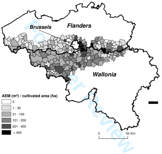
Central Belgium, northern France and southern England are all located in the loess belt 114
of northwestern Europe and are characterized by soils containing at least 60% silt which are 115
very sensitive to surface sealing (Boardman et al., 1994; Fig. 1). Major landscape changes 116
have been observed in these regions during the last decades (Souchère et al., 2003). 117
Urbanisation has expanded into rural areas. Numerous land consolidation programmes were 118
carried out in Belgium and in France without taking into account the limitation of 119
hydrological transfers at the catchment scale (Evrard et al., 2007b). A regional crop 120
specialisation is generally observed in many regions, such as large-scale maize cultivation in 121
Alsace (Van Dijk et al., 2005). Moreover, the area under grassland has decreased during the 122
three last decades in all of these regions as a result of the intensification of livestock breeding 123
and dairy farming. 124
125
2.1. Physical and demographic characteristics of the studied regions
126 127
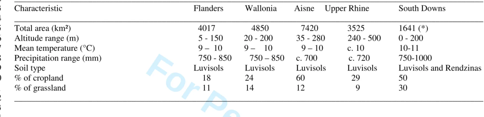
The physical characteristics of the studied regions are similar. They have significant 128
proportions of cropland and the areas in Belgium and northern France have gentle slopes; in 129
southern England slopes in the range 5 to 15 degrees are frequently cultivated (Table 1). 130
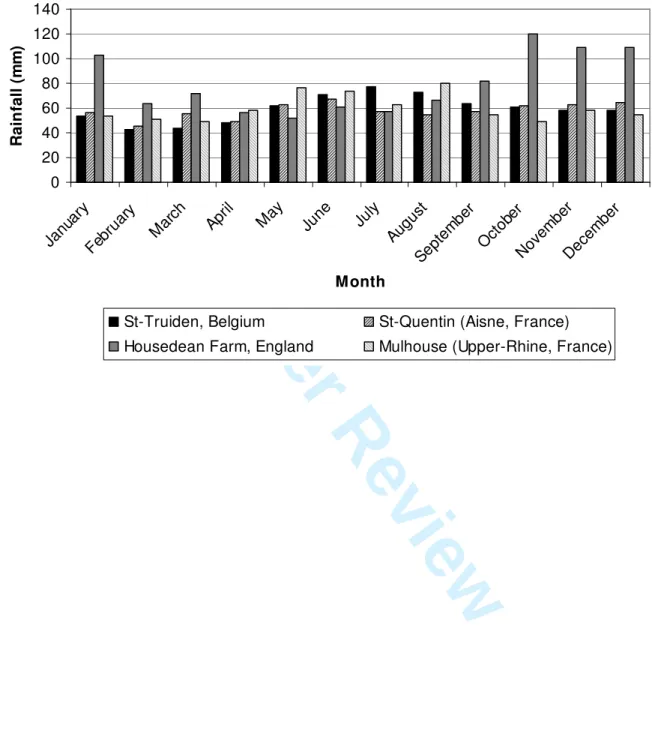
Mean annual temperature ranges from 9 to 11°C, while average precipitation reaches between 131
700 and 1000 mm. Rainfall is well distributed throughout the year in Belgium as well as in 132
northeastern France. In contrast, annual rainfall as well as the contribution of autumn and 133
winter rainfall is higher in southern England (Fig. 2). 134
In Belgium, muddy floods are concentrated in the central part of the country where 135
loess-derived soils dominate. The area is managed by the administrative entities of Flanders 136
and Wallonia (Fig. 1). The Brussels region is excluded, given cropland is virtually absent 137
from the capital city. 138
An important part of the areas affected by muddy floods in France is located in the 139
northern part of the country (Le Bissonnais et al., 2002). Two administrative units (the so-140
called ‘départements’ and referred to as ‘departments’ in the remainder of the text) with 141
particularly high muddy flood densities were selected for study (Aisne and Upper Rhine; Fig. 142 3 4 5 6 7 8 9 10 11 12 13 14 15 16 17 18 19 20 21 22 23 24 25 26 27 28 29 30 31 32 33 34 35 36 37 38 39 40 41 42 43 44 45 46 47 48 49 50 51 52 53 54 55 56 57 58 59 60
For Peer Review
1). The Aisne department is located in the Paris Basin. The central part of the department is 143
characterised by intensive cropping (winter cereals, sugar beet, oil-seed rape). The Upper 144
Rhine department is characterised by widespread monoculture of maize that provides a low 145
vegetation cover to the soil during the heavy thunderstorms of May and June (Van Dijk et al., 146
2005). Hilly regions of the department are particularly affected by muddy floods (e.g. 147
Sundgau, Fig. 1). 148
In southern England several areas have been affected by muddy floods but good data 149
only exists for the South Downs in the counties of East and West Sussex. The thin, stony soils 150
of the Downs limit the range of crops that can be grown and the area is dominated by winter 151
cereals, with some oil-seed rape and grazing for sheep. Dry valley systems drain to the south 152
where ephemeral flows of water encounter coastal resorts such as Brighton and Worthing. 153
The risk of muddy flooding is largely confined to the autumn and early winter months before 154
adequate crop cover is established. To the north of the South Downs, on loamy and sandy 155
soils on Cretaceous sandstone outcrops, intensive farming of cereals and spring-planted crops 156
of potatoes and maize give rise to muddy flooding especially around the town of Midhurst. 157
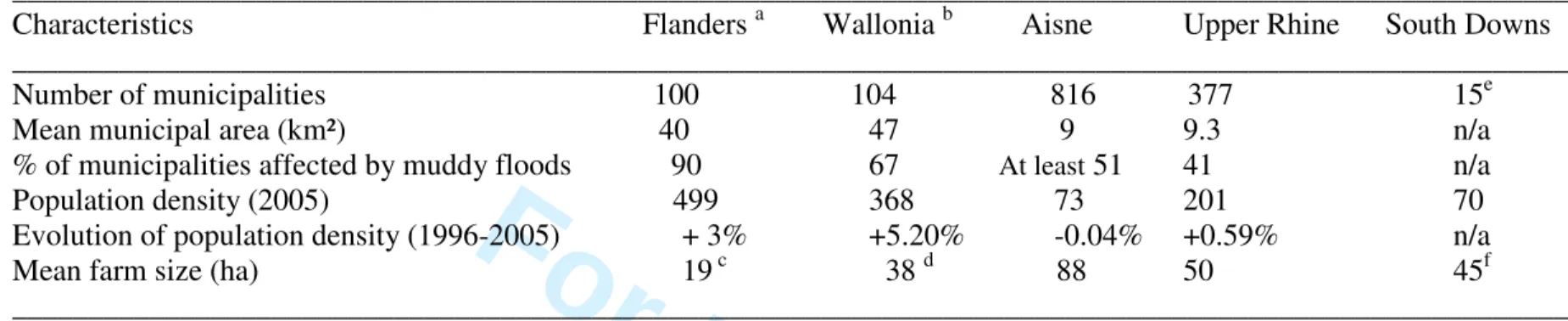
General demographic and farm characteristics of the studied regions are summarised 158
in Table 2. For a similar natural context, the studied regions show a large variation in 159
population densities (between 73 inh.km-2 in the Aisne and 499 inh.km-2 in Flanders). 160
Residential expansion is currently observed in the rural peripheries of large cities (e.g. 161
Brussels, Mulhouse; Caruso, 2002). Large farms dominate in northern France (88 ha on 162
average in the Aisne vs. 18-45 ha in the other regions). 163
164
2.2. Data sources on muddy flood frequency
165 166
The first problem arises when we want to obtain data on the extent and frequency of 167
muddy floods and compare them. There is no uniform and official database recording muddy 168
floods systematically in all the regions. Moreover, administrative units do not correspond to 169
natural regions, introducing a bias in the comparison of muddy flood frequency between the 170
different European regions. 171
In Belgium, the Disaster Fund (Belgian Ministry of Home Affairs) provides a database 172
of natural disasters. Floods are not qualified as ‘muddy’ but it is possible to restrict the search 173
excluding floods ‘due to the overtopping of rivers’. However, the Belgian Federal 174
Government approved on May 21, 2003 a law on compulsory insurance covering natural 175
disasters. Consequently, only the damage due to very exceptional events (leading to more 176 3 4 5 6 7 8 9 10 11 12 13 14 15 16 17 18 19 20 21 22 23 24 25 26 27 28 29 30 31 32 33 34 35 36 37 38 39 40 41 42 43 44 45 46 47 48 49 50 51 52 53 54 55 56 57 58 59 60
For Peer Review
than € 280 millions damage) will still be compensated by the Belgian state in the future. In 177
this context, the most reliable data source consists of a questionnaire sent to all municipalities 178
of central Belgium (Evrard et al., 2007a). This survey showed that 79 % of the municipalities 179
(n=201) were affected by at least one muddy flood over a ten year period (1991-2000 for 180
Wallonia ; 1995-2004 for Flanders). Of these 160 flooded municipalities, 22 % experienced 181
more than 10 floods in 10 years. 182
In the Aisne department, the municipalities potentially affected by muddy floods can 183
be identified thanks to the adoption of a ‘flood risk prevention scheme’(PPRI). In the past, 184
these schemes were not explicit on the nature of flooding. Since 2000, specific schemes aim 185
to cope with muddy floods. By 2006, 51% of the municipalities in the Aisne department 186
(n=834) required a flood prevention scheme but it had been approved in only 39 187
municipalities (5%). 188
In the Upper Rhine department, reports of natural disaster statements provide data on 189
the flooded municipalities. Since 1982, the French Natural Disaster law provides 190
compensation to the victims (Auzet et al., 2006). One third of the municipalities in the 191
department (n=377) were affected by at least one muddy flood during the period 1985-2003. 192
In southern England there is no official attempt to collect data on flooding or damage. 193
Boardman et al. (2003) report 138 incidents of damage to property by muddy floods in the 194
years 1976-2001. This relates to an area of the eastern South Downs from Worthing to 195
Eastbourne of about 496 km2. This estimate is based on personal observation and the use of 196
newspaper reports. There is no systematically collected data for the Midhurst area. In other 197
areas of England, there are anecdotal reports of muddy flooding, some newspaper reports and 198
occasional case studies in the academic literature (e.g. Boardman, 1995; Evans, 1996; Evans, 199
2004). 200
Overall, Flanders seems to be the most affected by muddy floods (Table 2). It is also 201
the region with the highest population density. However, a comparison of flood frequency 202
between administrative units that do not correspond to homogeneous natural regions is not 203
objective. 204
205
2.3. Data sources on muddy flood costs
206 207
Studies evaluating the costs induced by on- and off-site impacts of muddy floods are 208
very rare. Costs associated with single floods are available for certain municipalities (see e.g. 209
Verstraeten and Poesen, 1999; Evans, 1996; Evans, 2004; Boardman et al., 2006). A global 210 3 4 5 6 7 8 9 10 11 12 13 14 15 16 17 18 19 20 21 22 23 24 25 26 27 28 29 30 31 32 33 34 35 36 37 38 39 40 41 42 43 44 45 46 47 48 49 50 51 52 53 54 55 56 57 58 59 60
For Peer Review
estimate of off-site damages induced by muddy floods has been made for central Belgium 211
(between € 16 and 172 millions per year; Evrard et al., 2007a). 212
Costs induced by muddy floods in France are roughly estimated in the reports on 213
natural disaster statements. However, insurance companies refuse to publish damage cost data 214
because of confidentiality issues. Cost data are only made available for very local areas or 215
individual floods. For instance, muddy floods led to a mean damage cost of € 118 ha-1 yr-1 in 216
the village of Soucy (Aisne department) during a 10 year-period. 217
There is also little data in southern England on costs of damage. Robinson and 218
Blackman (1990) report off-site costs of serious muddy flooding in 1987 at four major sites in 219
Brighton suburbs in excess of € 957,000 excluding police and fire service costs. Most of them 220
were borne by local councils and insurers, but at least € 162,000 was uninsured. Two major 221
flooding incidents at Breaky Bottom Vineyard and farmhouse in 1987 and 2000 have resulted 222
in out-of-court settlements from the insurers of the up-valley farmer (Boardman 1988, 1994, 223
2000, 2001). Total cost to the insurers for the 2000-01 event alone were approximately € 1.45 224
million. 225
Overall, data available show that muddy floods induce high damage costs and that 226
these costs remain in the same order of magnitude in the different European regions. 227
228
3. Stakeholders involved in muddy flood mitigation 229
230
Muddy flood mitigation is at the crossroads of different policies (agriculture, 231
environment, land use planning and water management). The European Commission is in 232
charge of the European Common Agricultural Policy and prepares numerous environment-233
related directives. The national governments (or the regions in Belgium) have to transpose 234
and apply them locally. 235
In Belgium, the regional administration funds a large number of public or non-profit 236
making organisations that work on different topics (rural development, river or natural park 237
management), but without any effective coordination. Roads and watercourses are 238
hierarchically classified and managed by different administration levels (regional, provincial, 239
local), making any ‘hydrologically-consistent’ supervision very difficult. For instance, 240
watercourse managers must cope with siltation of rivers without any possibility to control 241
erosion on the cultivated land draining to the rivers. 242
In France, a hierarchical structure prevails (State-Region-Department-Municipality). 243
Several state services and agencies (Departmental Agency of Agriculture and Forest – DDAF; 244 3 4 5 6 7 8 9 10 11 12 13 14 15 16 17 18 19 20 21 22 23 24 25 26 27 28 29 30 31 32 33 34 35 36 37 38 39 40 41 42 43 44 45 46 47 48 49 50 51 52 53 54 55 56 57 58 59 60
For Peer Review
Departmental Agency of Equipment – DDE; Water Agencies; Departmental Councils) are 245
implicated in erosion management as well as local farmers’ trade unions (‘Chambres 246
d’Agriculture’). Even though there is collaboration between these institutions, there is 247
generally no specific structure to coordinate muddy flood mitigation. Therefore, an ‘erosion 248
task force’ (‘mission érosion’) was set up in 1998 in the Aisne. It does not replace the other 249
agencies, but aims to set up specific, individual and local actions. This initiative remains very 250
local and highlights different management approaches between the French departments. The 251
dynamism of local farmers’ trade unions and departmental authorities has a major influence 252
on the implementation of local actions to control erosion phenomena. 253
In England, Defra (Department for Environment, Food and Rural Affairs) is 254
responsible for agricultural policy and thus for erosion and muddy flooding. Water quality 255
issues under the Water Framework Directive are devolved by Defra to the Environment 256
Agency. Natural England is in charge of the impacts on biodiversity and the Highways 257
Agency and local authorities are responsible for flooded roads and adjacent property. 258
Who is in charge of risk mitigation at local scales depends not only on large-scale 259
policies (e.g. CAP) but also on field realities. Large-scale policies are not always easily 260
applicable in the local geomorphologic context. Moreover, recent investigation of risk 261
perception in the Upper Rhine department shows that the population demands from local 262
authorities that they implement ‘visible’ protection measures (Heitz et al., in press). This 263
experience can also be reproduced in England (Evans and Boardman, 2003). Policy is hence 264
decided at the European scale whereas the population asks for local actions. 265
266
4. Muddy flood mitigation measures resulting from the CAP 267
268
In Belgium, the regions are responsible for the implementation of agriculture, 269
environment and land use planning policies in the framework of the EU guidelines. In France, 270
the national ministry of agriculture is in charge of these policies. Decentralized state agencies 271
are responsible for the implementation and the control of agricultural and environmental 272
rules. Policy in England is characterised by centralisation with little devolution to regional or 273 local government. 274 275 4.1. Cross-compliance 276 277 3 4 5 6 7 8 9 10 11 12 13 14 15 16 17 18 19 20 21 22 23 24 25 26 27 28 29 30 31 32 33 34 35 36 37 38 39 40 41 42 43 44 45 46 47 48 49 50 51 52 53 54 55 56 57 58 59 60
For Peer Review
Cross compliance regarding erosion mitigation consists in a series of standards that 278
farmers need to meet in order to receive the totality of their subsidies. It has been 279
implemented with regional specifications (Table 3a). In Wallonia, specific rules are applied to 280
fields having at least 50% of their area (or minimum 0.5 ha) with a slope steeper than 10%. In 281
contrast, Flanders bases its rules on the results of an adapted version of the RUSLE equation 282
applied for each cultivated field of the region (see e.g. Verstraeten et al., 2001). Alternative 283
farming practices must be used or Agri-Environmental Measures (AEMs) must be installed on 284
the fields at risk. In France, cross-compliance relies on respect for good agricultural and 285
environmental conditions. A cover crop (‘couvert environnemental’) or grass buffer strips 286
must also be sown on at least 3% of the cultivated surface for which subsidies are granted. In 287
England, in order to receive payments (Single Payment Scheme), farmers have to maintain 288
land in Good Agricultural and Environmental Condition (GAEC) for a payment of €43.5 ha-1. 289
Farmers can then be volunteer to enter an Entry Level Scheme of Environmental Stewardship 290
if they wish for further payments. To enter the Higher level Scheme, farmers have to bid 291
competitively. As part of Entry Level and Higher Level schemes, a Farm Environmental 292
Record has to be produced and record, among other things, land suffering from erosion and 293
runoff. Each farm has a points target related to farm size that they must attain by choosing 294
from a range of options. Some of these options help control runoff e.g. grass buffer strips. 295
There are also options related to management of high erosion risk cultivated land, of special 296
concern being that under root crops such as potatoes and sugar beet, maize and outdoor pigs. 297
298
4.2. Agri-Environmental Measures
299 300
Farmers have to fulfil minimum environmental standards in order to receive their EU 301
single payments. If the farmers want to go beyond those standards, they have the possibility to 302
implement Agri-Environmental Measures (AEMs) during a five-year minimum period. They 303
are hence paid by society for the environmental service they deliver. Agri-environmental 304
schemes are flexible and implemented differently according to the state or region in Europe 305
(European Commission, 2005). Such flexibility enables the regions or states to meet certain 306
local environmental needs. 307 308 Belgium 309 310 3 4 5 6 7 8 9 10 11 12 13 14 15 16 17 18 19 20 21 22 23 24 25 26 27 28 29 30 31 32 33 34 35 36 37 38 39 40 41 42 43 44 45 46 47 48 49 50 51 52 53 54 55 56 57 58 59 60
For Peer Review
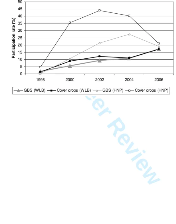
In Wallonia, two AEMs contribute to runoff and erosion mitigation even if they were 311
not designed to achieve this specific objective: (i) installation of Grass Buffer Strips (GBS) 312
and (ii) sowing of cover crops during the dormant period. Farmers’ participation rate to these 313
measures increased from 1998 to 2006 in the Walloon loess belt and reached 17% in 2006 314
(Fig. 3). In the ‘Hillsland natural park’, agricultural advisers convinced farmers to install 315
GBS where muddy floods have routinely damaged roads or houses. Consequently, in 2002, 316
farmers’ participation rate to AEMs was much higher in the area covered by the park (27% 317
for GBS; 40% for sowing a cover crop during the dormant period) as compared to the mean 318
rates for the Walloon loess belt (12% for GBS and cover crops). The extension officers 319
stopped their advice at the end of 2002 and the farmers’ participation rate in the area covered 320
by the park subsequently decreased until it reached the mean participation level for the 321
Walloon loess belt (Fig. 3). 322
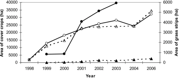
In Flanders, similar AEMs (management of field edges; sowing of cover crops) have 323
been available to farmers since 1999. The increase in the area with cover crops occurred later 324
than in Wallonia (Fig. 4). Cover crops have not been subsidised by the Flemish government 325
since 2007, since it is considered that it should be part of standard good environmental 326
practices. In contrast, the area of cover crops keeps increasing in Wallonia, after a slight 327
decrease in 2004 due to important changes to the Walloon agri-environmental scheme. 328
Since January, 2005, a new AEM enables the Walloon farmers to install GBS with the 329
specific objective of erosion mitigation for which they need an agreement designed by an 330
expert. This new rule leads to an extra subsidy (€ 1250 ha-1 insteadof € 900 ha-1 for standard 331
GBS). In Flanders, a package of five AEMs aiming at erosion control (dam and retention 332
pond; direct drilling; grass buffer strips; grassed waterway; minimum tillage) exists since 333
2005. Overall, AEMs for erosion mitigation are more widespread in Wallonia than in 334
Flanders (Fig. 5). Several explanatory factors can be put forward. First, in Wallonia, extension 335
officers visit the fields where erosion problems are observed and propose to the farmers the 336
most suitable solution. Second, ‘word of mouth’ about AEMs is probably more efficient 337
among the Walloon farmers, their number being smaller and their capacities to invest larger, 338
because of the much greater farm size (Table 2). 339
340
France 341
342
Numerous AEMs are available to French farmers, but two types of measures represent 343
60% of total grants: (i) the subsidies for least favoured areas and (ii) the subsidies for the 344 3 4 5 6 7 8 9 10 11 12 13 14 15 16 17 18 19 20 21 22 23 24 25 26 27 28 29 30 31 32 33 34 35 36 37 38 39 40 41 42 43 44 45 46 47 48 49 50 51 52 53 54 55 56 57 58 59 60
For Peer Review
maintenance of extensive breeding systems (PHAEs for ‘Primes Herbagères Agri-345
Environnement’). The last measure is mostly applied where grassland dominates, which is not 346
the case in the Upper Rhine nor in the Aisne. In France, there are no specific AEMs aimed at 347
erosion mitigation. Several AEMs exist, but they aim to meet more general objectives (e.g. 348
conversion to sustainable farming and integrated landscape management). 349
The CTEs (‘Contrats Territoriaux d’Exploitation’) were introduced in 1999. They 350
were the first tool promoting the multifunctional role of agriculture in France. They focused 351
on improving water quality (conversion of cropland into grassland, installation of grass strips, 352
limited use of fertilisers) and soil quality (planting of hedges, no-till or reduced tillage). At the 353
national scale, farms that adopted such AEMs are concentrated in rural and mountainous areas 354
(Vosges, Alps, Pyrenees, Massif Central; Urbano and Vollet, 2005). CTEs were replaced in 355
2003 by CADs (‘Contrats d’Agriculture Durable’) which aim to allow the conversion to more 356
sustainable farming. Farmers can choose to install proposed measures such as new grassland 357
or planting of hedges. However, the number of farmers concerned remains limited (e.g. 99 358
contracts in 2004 in the Aisne department). The transition period between CTE and CAD 359
regimes was rather confusing for farmers and many of them were discouraged. 360
There is a lack of information about the specific financial amounts granted for erosion 361
mitigation in France. Developing a means of producing, centralising and diffusing such 362
statistics should be a priority for the relevant agencies. 363
364
England
365 366
Under the Single Payment Scheme, farmers have to keep land in Good Agricultural 367
and Environmental Condition in order to receive payments. As part of this, they have to fill 368
in a Soil Protection Review. Stewardship schemes, as outlined above, can be taken up and for 369
those a Farm Environmental Record is needed. On fields at risk of erosion, they can gain 370
points by agreeing not keep outdoor pigs, to plant potatoes, sugar beet or maize. Specific 371
advice on the management of maize is offered (RDS, 2005). Detailed risk assessment 372
procedures, and advice on management of specific arable crops to avoid erosion and runoff is 373
given in Defra (2005) and Cuttle et al. (2006). Risk assessment includes risk of runoff leaving 374
fields and damaging surface waters and roads and thus muddy flooding. 375 376 Comparative discussion 377 378 3 4 5 6 7 8 9 10 11 12 13 14 15 16 17 18 19 20 21 22 23 24 25 26 27 28 29 30 31 32 33 34 35 36 37 38 39 40 41 42 43 44 45 46 47 48 49 50 51 52 53 54 55 56 57 58 59 60
For Peer Review
If we focus on AEMs dealing with erosion and runoff control in the different regions 379
(Table 3b), a comparison seems to be very difficult, given that AEMs objectives and practical 380
requirements are completely different. Overall, adoption of AEMs by the farmers increases in 381
Belgium and in France. However, their implementation relies on individual farmers’ 382
decisions, with the exception of GBS for erosion mitigation in Wallonia. At least, rules for the 383
location of AEMs should be introduced, whatever the final objective. It is not only important 384
for erosion mitigation, but also for biodiversity conservation (e.g. Berger et al., 2003). 385
Actions to increase awareness and to inform the farmers at the local scale proved to be 386
effective (e.g. in the Hillsland Natural Park, Wallonia). The measures should also be more 387
targeted. Each year, c. € 2000 millions are spent on AEMs in the EU (European Commission, 388
2005). However, a very low proportion of this amount is dedicated to erosion mitigation. The 389
member states should fund specific studies to make sure the measures they support serve their 390
purpose. AEMs are generally applied to a larger extent in rural and mountainous areas, where 391
they constitute an important part of the farmers’ income. In contrast, in the very productive 392
loess regions, most farmers still consider that a more intense agricultural use of the soil will 393
generate higher incomes even over the long term, which explains a lower adoption of AEMs 394
in those areas. Still most off-site impacts of agriculture are observed in the intensively farmed 395
regions. 396
Even though they generally aim to facilitate their implementation, changes in AEM 397
schemes and practical requirements can induce discouragement among farmers if they are too 398
frequent (e.g. transition between CTEs and CADs in France; new Walloon agri-environmental 399
programme in 2005). A certain stability is needed, as well as support from local agricultural 400
advisors; this is beginning to happen in England through schemes such as the Catchment 401
Sensitive Farming Initiative. The links between advisors and the scientific community could 402
also be improved. 403
404
5. Regional mitigation schemes 405
406
5.1. Belgium
407 408
In 1997, the Flemish government recognised erosion as an environmental problem, 409
leading among other consequences to muddy floods. It adopted an ‘erosion decree’ in 410
December, 2001, allowing municipalities to receive funding to carry out a local plan against 411
erosion (€ 12.5 ha-1 covered by the plan) and implement erosion control measures in the field 412 3 4 5 6 7 8 9 10 11 12 13 14 15 16 17 18 19 20 21 22 23 24 25 26 27 28 29 30 31 32 33 34 35 36 37 38 39 40 41 42 43 44 45 46 47 48 49 50 51 52 53 54 55 56 57 58 59 60
For Peer Review
(75% of total amount; Verstraeten et al., 2003). By 2007, 85% of the municipalities in the 413
Flemish loess belt had started the process leading to the drawing up of such a scheme. It does 414
not mean that control measures are being installed in all of these municipalities. In many 415
cases, the schemes have been drawn but they have not been applied so far. The Flemish Water 416
Ordinance (‘watertoets’) also imposes the evaluation of the impact of any new construction 417
on water issues before the deliverance of planning permission. 418
In Wallonia, the government decided to tackle the flooding problem designing an 419
integrated scheme called ‘Rainfall Scheme’ (‘Plan Pluies’ in French) in 2003. In the near 420
future, similar schemes to the ones proposed in Flanders will be funded by the Walloon 421
regional authorities. Maps of flood prone areas (one for river flooding and another for local 422
flooding) are also being drawn and should serve as a useful decision tool for regional land use 423 planning. 424 425 5.2. France 426 427
In France, several tools are designed at the departmental scale. The creation of specific 428
schemes at the departmental level was beneficial for their local implementation. Two main 429
tools are available: risk prevention schemes (PPR- ‘Plan de Prévention des Risques’) and 430
SAGE schemes (‘Schéma d’Aménagement et de Gestion de l’Eau’ – ‘Land use and water 431
management planning schemes’). 432
PPR schemes have been created to cope with given risks (forest fire, earthquake, 433
flood). Five maps must be systematically drawn (hazard location, historical evolution, 434
vulnerability, places that are most at risk, global risk). According to these maps, specific 435
measures can be prescribed: building of protection installations, rules for new buildings and, 436
in extreme cases, expropriation. However, the adoption of a PPR does not necessarily lead to 437
the installation of measures in the field. Furthermore, the latter consist most of the time of 438
protection measures (e.g. dams) and do not prevent erosion and runoff generation in the 439
fields. 440
SAGE schemes aim at water resource planning and management. This planning 441
document is designed at the river basin scale by different regional agencies. Since it has legal 442
power, the other decisions related to water management must take the SAGE provisions into 443
account. This tool has several advantages compared to the flood prevention scheme. First, it 444
works at the catchment scale. Second, it is an integrated tool that not only focuses on runoff 445
and muddy floods but it also deals with water pollution, water protection and fish breeding. 446 3 4 5 6 7 8 9 10 11 12 13 14 15 16 17 18 19 20 21 22 23 24 25 26 27 28 29 30 31 32 33 34 35 36 37 38 39 40 41 42 43 44 45 46 47 48 49 50 51 52 53 54 55 56 57 58 59 60
For Peer Review
Stakeholder meetings to increase awareness are organised in the framework of the SAGE 447
schemes. They are therefore potential measures for a possible centralisation of competences, 448
but they remain rather complex to implement. By 2005, 31 SAGE schemes had been created 449
in France, and 101 more schemes are being implemented. 450
The Upper Rhine department also proposes a specific integrated tool called ‘Gerplan’ 451
to promote landscape multifunctionality and, if relevant, to control muddy floods. It aims to 452
define concrete management proposals for the different landscape components (cropland, 453
orchards, riparian zones). Actions are planned for a 10 year-period and funding is provided by 454
the departmental authorities. Planned actions (e.g. changes of farming practices, construction 455
of retention ponds) are detailed for each field at an operational scale (1: 5000). By 2007, 22 456
local boards grouping several municipalities in Upper Rhine had decided to implement 457
Gerplans, which are drawn up by consultants on behalf of farmers’ trade unions and 458
agriculture local state agencies. 459
The French government also adopted a law on natural risks in 2003 according to 460
which a commission dealing with such risks has to be created in each department (Auzet et 461
al., 2006). This law implies that during the sale of a property, potential owners are 462
systematically informed of the risks relative to its location. This measure is not only applied 463
to natural risks (earthquakes, floods) but also to technological risks (e.g. presence of Seveso 464
factories). 465
Moreover, a decree of 2005 specifically deals with erosion mitigation. The 466
departmental authorities have the possibility to delineate erosion prone areas and to draw up a 467
mitigation scheme. Local stakeholders must meet the objectives prescribed by the authorities 468
in the scheme within three years. 469
470
5.3. England
471 472
Initiatives relevant to control of muddy flooding are the Environmentally Sensitive 473
Area scheme (established in 1987), which funds farmers to revert arable fields to grassland. 474
On the South Downs, 5000ha have been entered into the scheme (SDMP, 2004). In 475
partnership with other agencies, the Environment Agency has funded a Landcare scheme 476
aimed at reducing runoff from farmers’ fields into the River Rother around Midhurst (Horsey, 477
2006). This has now been discontinued. In 2005, Defra identified 42 catchments in England 478
and are funding a Catchment Sensitive Farming scheme (2005-08) to address issues of diffuse 479
pollution (Defra, 2007). None of the priority catchments are in the area under consideration; 480 3 4 5 6 7 8 9 10 11 12 13 14 15 16 17 18 19 20 21 22 23 24 25 26 27 28 29 30 31 32 33 34 35 36 37 38 39 40 41 42 43 44 45 46 47 48 49 50 51 52 53 54 55 56 57 58 59 60
For Peer Review
some of the 42 have muddy flooding problems such as the Lugg in Herefordshire (Walker, 481
2007). Defra have also published a First Soil Action Plan for England (Defra, 2006); and 482
most usefully a guide to controlling soil erosion (Defra, 2007). There are several over-lapping 483
and non-coordinated schemes some of which are funded for a short time. 484
485
5.4. Diagnosis: spatial mismatch
486 487
Multiplicity of state agencies and splitting-up of the initiatives is apparent (Table 4). 488
Based on the stakeholders involved and the main tools available for erosion and flood 489
mitigation, two main types of measures can be pointed out: 490
(i) AEMs that are directly installed by farmers, but the objective and the practical 491
requirements of which are defined by national (France and England) or regional (Belgium) 492
authorities; 493
(ii) Specific schemes at the municipal scale (flood risk prevention schemes in France; erosion 494
mitigation scheme in Flanders) or at the river basin scale (SAGE schemes in France). The 495
latter do not exist at present in Wallonia but specific AEMs for erosion mitigation requiring 496
an expert’s approval are proposed. 497
Overall, there is a spatial mismatch between, on the one hand, the scale at which 498
muddy floods are triggered (small catchment scale) and, on the other hand, the scale at which 499
farmers (farm-scale) and public authorities (municipality- or region scale) can operate. This is 500
mainly true in small Belgian municipalities as well as in France. In England neither County 501
Councils nor District Councils have any responsibility for flood protection either with regard 502
to rivers or muddy floods from agricultural land. 503
In Flanders, the Melsterbeek Water Board (264 km²), a grouping of five municipalities 504
as well as the local water agency, is the only area where erosion and flood control measures 505
are installed in the framework of a catchment-integrated approach. Even though the EU Water 506
Framework Directive requires that countries set up management plans at the river basin scale 507
by December 2009, the French government has rather encouraged the creation of municipal-508
scale risk prevention schemes since 2000. Five years later, it has been updated with 509
significant financial investment to 5000 schemes. In such a context, prevention schemes 510
aimed at mitigating risk, largely dominate. The advantage is that creating one tool for all 511
types of risks facilitates collective actions. Inverting the trend by strengthening catchment 512
agencies which should be better known to the population and the authorities is the major 513
challenge for the future. It presupposes that municipalities learn to work together. The 514 3 4 5 6 7 8 9 10 11 12 13 14 15 16 17 18 19 20 21 22 23 24 25 26 27 28 29 30 31 32 33 34 35 36 37 38 39 40 41 42 43 44 45 46 47 48 49 50 51 52 53 54 55 56 57 58 59 60
For Peer Review
municipalities of central Belgium also have to take up the challenge. In twenty hotspot 515
municipalities of central Belgium that were studied in detail (Evrard et al., 2007a), the runoff 516
generation area and the flooded zone were located in different municipalities in 62 cases (17% 517
of flooded areas). Of these 62 areas, an important part of the drainage basin was located in the 518
other Belgian region (24% of the cases), or even in another country in six cases (10%). A 519
similar situation is observed in the Upper Rhine department where 20% of muddy floods are 520
generated in a municipality and affect another village located downstream. 521
In England also, the Catchment Sensitive Farming (CSF) scheme concentrates on 522
perceived hotspots of risk to rivers and targets catchments which have nature conservation 523
value where sediments or nutrients are a threat. The scheme however is voluntary and farmers 524
can opt-in or out. Grants are available for capital works and the CSF officer provides advice 525
on prevention of erosion and runoff to the farmers. The scheme is funded for two years and is 526
at present under review. Many bodies are putting emphasis on the Environmental Stewardship 527
scheme since most farmers are expected to opt-in in order to receive payments. Potentially, 528
though the options are very limited (buffer strips and land use change), the scheme may have 529
a positive impact. Unknown factors are whether there will be rigorous policing of measures 530
and their effectiveness, and if the monetary incentives will be sufficient to attract growers of 531
high-value crops (e.g. maize, potatoes and sugar beet) on high erosion risk land. However, if 532
there are muddy floods from a farmer’s land he is not complying with GAEC conditions of 533
the Single Payment Scheme, which may make it easier to enforce the regulations providing 534
such floods are reported. This is a matter of educating the general public. 535
536
6. Local measures against muddy floods 537
538
6.1. Measures taken by the municipalities
539 540 541
In Flanders, the municipalities frequently affected by muddy floods or severe erosion 542
can decide to implement a municipal mitigation scheme. This is not the case in the other 543
regions, but similar tools will soon be available for erosion prone areas in France and 544
Wallonia. Following a visit to frequently flooded Walloon municipalities (n=12; Evrard et al., 545
2007a), two main observations could be made: 1) muddy floods are considered a major 546
problem for the population in 42% of the cases and they got worse during the last decade 547
according to 83% of the local authorities; 2) there is no integrated flood management in 83% 548
of the cases. Furthermore, in 83% of the municipalities, the only actions considered are 549 3 4 5 6 7 8 9 10 11 12 13 14 15 16 17 18 19 20 21 22 23 24 25 26 27 28 29 30 31 32 33 34 35 36 37 38 39 40 41 42 43 44 45 46 47 48 49 50 51 52 53 54 55 56 57 58 59 60
For Peer Review
modifications to the sewage system or construction of retention ponds. The construction of a 550
retention pond is very expensive (mean cost of € 380,000 (Verstraeten and Poesen, 1999), and 551
does not prevent runoff generation. Still the local authorities consider that rainfall intensity is 552
the most influential natural factor and frequently quote large-scale potato and maize crops as 553
important human factors triggering muddy floods. Certain municipalities therefore decided to 554
tackle the problem. For instance, a Walloon municipality confronted with 37 areas affected by 555
muddy floods grants specific subsidies to local farmers for the installation of GBS in flood 556
prone areas. In the Walloon Brabant province, the Rural Foundation of Wallonia organises 557
municipal commissions (‘commissions agricoles communales’) where local authorities, 558
farmers and inhabitants can discuss specific matters such as erosion mitigation. Finally, 559
certain river management committees (‘contrats rivières’) intend to inform and increase 560
awareness of erosion among the population and the farmers. They can help solving problems 561
in individual cases. 562
French local authorities (e.g. in the Upper Rhine) are subjected to pressure from the 563
population to instigate control measures. They can expropriate agricultural fields to install 564
them. Even though they are aware of the implication that floods may be triggered by 565
inappropriate land use planning, pressure is sometimes too important. In some cases, the 566
mayors demand a concerted implementation of measures at the catchment scale, implicating 567
their counterparts in upstream villages (Heitz, 2005). Local urban schemes (PLUs or ‘Plans 568
Locaux d’Urbanisme’) take risk areas into account to define land approved for development. 569
They are the only official document of land use planning available at the local scale in France. 570
They are drawn up on behalf of the municipal authorities but also approved by departmental 571
and regional authorities. 572
In England local authorities have no statutory responsibility to protect people from 573
muddy flooding as the first case of its kind made quite clear (Stammers and Boardman, 1984). 574
In practice, whenever people and their properties are damaged by flooding, they appeal to 575
their political representatives and they put pressure on local councils. Councils therefore have 576
often acted as organisers of emergency defence measures such as ditches, dams and pipes. 577
Councils have attempted to organise protection over longer time periods but have been less 578
successful and have been reluctant to commit resources to this process. Evans and Boardman 579
(2003) describe repeated flooding of houses in the Sompting catchment on the South Downs 580
and the political process in achieving success. In fact, limited land use change driven by Set 581
Aside regulations led to control of flooding. Highway authorities also have power under the 582
Highways Act (1980) to control runoff from fields that reaches roads. This has only been used 583 3 4 5 6 7 8 9 10 11 12 13 14 15 16 17 18 19 20 21 22 23 24 25 26 27 28 29 30 31 32 33 34 35 36 37 38 39 40 41 42 43 44 45 46 47 48 49 50 51 52 53 54 55 56 57 58 59 60
For Peer Review
in the Isle of Wight (Boardman, 1994). In exceptional cases, where local councils own 584
agricultural land, they have instituted either land use change or the building of dams in order 585
to protect communities from flooding (Boardman et al., 2003). In areas such as the South 586
Downs where flooding does not occur every year or in the same place perhaps for many 587
years, there is a problem of lack of institutional memory within local councils in that they deal 588
with muddy flood problems occasionally. No councils have specialists to deal with erosion 589
and runoff problems but generally rely on all-purpose engineers. There is also the temptation 590
to believe that measures put in place at one time will solve the problem without constant 591
maintenance (e.g. ditch clearance). Finally, there is no co-ordinating body to bring together 592
the experience of local councils. 593
594
6.2. Measures taken by farmers
595 596
Numerous farmers feel responsible for erosion processes (e.g. Bielders et al., 2003). A 597
couple of them have decided on their own initiatives to alleviate muddy floods. In the Aisne 598
department, the ‘erosion task force’ can propose the installation of several measures (e.g. 599
GBS, dams and buffer ditches) in their fields. Moreover, in the Aisne, several farmers sow 600
alternate strips of maize and wheat to limit runoff generation and concentration. In the 601
Belgian Melsterbeek catchment, farmers similarly decided to implement double sowing in the 602
thalweg of their fields (Gyssels et al., 2002). On the South Downs, southern England, several 603
farmers have built retention dams to protect their own or others property from muddy floods. 604
These have usually been built as an emergency response to flooding. In some cases they have 605
failed. Changes in land use or farming practice directly attributable to the risk of muddy 606
flooding are difficult to confirm (but see Evans and Boardman, 2003). Direct drilling 607
(minimal cultivation) is rare but is being used by one farmer to reduce the risk of flooding his 608
neighbour. Another example of a farmer’s individual actions to mitigate erosion in England is 609
described by Evans (2006). 610
Consultation between several farmers of the same municipality is also possible. They 611
can decide to coordinate the location of the different crops to limit runoff generation at the 612
catchment scale (Joannon et al., 2006). Certain municipalities in the Upper Rhine department 613
(e.g. Morschwiller-le-Bas) have organised such consultation. However, these initiatives 614
remain very local (Christen and Wintz, 2006). The importance of this consultation 615
phenomenon is impossible to quantify, but it seems to be more widespread in France than in 616
Belgium, given the much larger mean size of the French farms (Table 2). Furthermore, in 617 3 4 5 6 7 8 9 10 11 12 13 14 15 16 17 18 19 20 21 22 23 24 25 26 27 28 29 30 31 32 33 34 35 36 37 38 39 40 41 42 43 44 45 46 47 48 49 50 51 52 53 54 55 56 57 58 59 60
For Peer Review
Belgium, many farmers are reluctant to discuss it. Many of them have commitments with 618
agro-food companies to produce crops (e.g. carrots, peas). It becomes difficult to combine 619
their different commitments with the consultation about crop location at the catchment scale. 620
In France, the Supreme Court of Appeal has perhaps set a precedent for conflicts 621
between farmers due to erosion. A fish breeder whose basins were damaged by runoff loaded 622
with sediments instituted proceedings against the farmer cultivating the upstream slope. The 623
Supreme Court quashed a sentence stipulating that runoff and erosion were due to heavy 624
rainfall. The Supreme Court argued that the farmer cultivating the upstream fields was 625
responsible for the damage induced to the downstream fish breeding basins. 626
In England, there is some history of legal attempts to protect properties from runoff 627
from agricultural land and to sue those responsible for the damage for negligence. Legal 628
advice in several cases suggests that to be successful, it must be shown that the farmer was 629
aware of the risk to his neighbour e.g by previous flooding; that the rainfall event was not 630
‘exceptional’; that farming practices including land use decisions were the cause of the 631
flooding; that no measures were taken to protect the neighbour (Boardman, 2003). Out-of-632
court settlements in the Breaky Bottom flooding incidents show that these criteria can be met 633
in some cases. In future the threat of legal action may act as a deterrent at sites with a history 634 of previous flooding. 635 636 7. Conclusions 637 638
Muddy floods are a frequent and widespread phenomenon in the European loess belt. 639
However, there is no standard database recording these events and data on damage costs 640
remain rare or limited to certain municipalities. A comparison of flood frequency between 641
different European regions is not easy, since administrative units do not correspond to 642
homogeneous natural regions. Over the last decade, there has been a raising of consciousness 643
among all the stakeholders involved in muddy flood management. Huge costs induced by the 644
floods in numerous villages help justify the rapid installation of control measures. However, 645
people and farmers remain insufficiently informed of the processes involved and the 646
mitigation tools available. French investigations showed that the affected populations 647
particularly appreciate the construction of retention ponds, considering that they protect them 648
efficiently. Consultation between stakeholders at the local scale should be encouraged, e.g. in 649
the framework of municipal agricultural commissions. Farmers are often overwhelmed with 650
administrative tasks. Thanks to local coordinators’ help, the adoption of AEMs aiming at 651 3 4 5 6 7 8 9 10 11 12 13 14 15 16 17 18 19 20 21 22 23 24 25 26 27 28 29 30 31 32 33 34 35 36 37 38 39 40 41 42 43 44 45 46 47 48 49 50 51 52 53 54 55 56 57 58 59 60
For Peer Review
erosion mitigation is more successful. The creation of an integrated scheme to mitigate 652
erosion and muddy floods is now considered in all the studied regions. Furthermore, 653
concerted actions between municipalities must be a priority, given that the limits of 654
municipalities do not coincide with hydrological units. A solution to the observed ‘spatial 655
mismatch’ would be to enhance existing structures that are efficient (Belgian water agencies 656
and natural parks, French SAGE schemes, English Catchment Sensitive Farming schemes) or 657
to widen the application field of existing tools (e.g. flood prevention schemes at the catchment 658
scale). Catchment agencies concentrating legal, environmental and financial competences 659
(like the water boards in the Netherlands) could also help control floods and erosion. 660
Individual measures (AEMs) installed by farmers after an expert’s approval could also be 661
stimulated. Alternatively, rules for an optimal location of AEMs should be imposed. 662
Furthermore, the effectiveness of the current AEMs should be assessed. A comparison of the 663
tools available in different countries to combat erosion and muddy floods should be carried 664
out to see whether they serve their purpose. Muddy flood management can either focus on soil 665
and water conservation or on property protection. Conflicts of viewpoints can arise and 666
influence the type of measures that will finally be implemented. Farmers’ conversion to 667
alternative farming practices limiting runoff and erosion production in the fields must also be 668
progressively encouraged to complete the ‘palliative’ approach currently pursued and 669
assessed in pilot areas. This could be achieved through the creation of new specific AEMs. 670
671
Acknowledgements 672
The authors want to thank the following administrations for providing data : Vlaamse 673
Overheid – Departement Leefmilieu, Natuur en Energie – Afdeling Land en 674
Bodembescherming; Ministère de la Région Wallonne – Direction Générale de l’Agriculture; 675
Groupe Interuniversitaire de Recherches en Ecologie Appliquée (GIREA) at the Université 676
catholique de Louvain and especially Alain Le Roi; Chambre d’Agriculture de Laon; Mission 677
Érosion de l’Aisne. This is the LSCE contribution n° X. 678
679
References 680
681
Auzet AV, Boiffin J, Papy F, Maucorps J, Ouvry JF. 1990. An approach to the assessment of 682
erosion forms, erosion risks on agricultural land in the Northern Paris Basin, France. In 683
Boardman J, Dearing J, Foster I (Eds.). Soil erosion on agricultural land. Wiley: Chichester; 684 384-400. 685 3 4 5 6 7 8 9 10 11 12 13 14 15 16 17 18 19 20 21 22 23 24 25 26 27 28 29 30 31 32 33 34 35 36 37 38 39 40 41 42 43 44 45 46 47 48 49 50 51 52 53 54 55 56 57 58 59 60
For Peer Review
686Auzet AV, Le Bissonnais Y, Souchère V. 2006. France. In Boardman J, Poesen J (Eds). Soil 687
erosion in Europe. Wiley: Chichester; 69-383.
688 689
Berger G, Pfeffer H, Kächele H, Andreas S, Hoffmann J. 2003. Nature protection in 690
agricultural landscapes by setting aside unproductive areas and ecotones with arable fields 691
(“Infield Nature Protection Spots”). Journal for Nature Conservation 11: 221-233. 692
693
Bielders CL, Ramelot C, Persoons E. 2003. Farmer perception of runoff and erosion and 694
extent of flooding in the silt-loam belt of the Belgian Walloon Region. Environmental Science 695
& Policy 6: 85 – 93.
696 697
Boardman J. 1988. Severe erosion on agricultural land in East Sussex, UK October 1987. Soil 698
Technology 1: 333-348.
699 700
Boardman J. 1994. Property damage by run-off from agricultural land. Town & Country 701
Planning 63(9): 249-251.
702 703
Boardman J. 1995. Hillslopes: slope erosion and mudflows. In DoE, The Occurrence and 704
Significance of Erosion, Deposition and Flooding in Great Britain. HMSO: London; 37-49.
705 706
Boardman J. 2000. The problem of muddy floods. Rural Property Bulletin Nov/Dec 2000; 26-707
27. 708 709
Boardman J. 2001. Storms, floods and soil erosion on the South Downs, East Sussex, autumn 710
and winter 2000-01. Geography 86 (4): 346-355. 711
712
Boardman J. 2003. Soil erosion and flooding on the eastern South Downs, southern England, 713
1976-2001. Transactions Institute British Geographers 28(2): 176-196. 714
715
Boardman J, Ligneau L, De Roo A, Vandaele K. 1994. Flooding of property by runoff from 716
agricultural land in northwestern Europe. Geomorphology 10: 183-196. 717 718 3 4 5 6 7 8 9 10 11 12 13 14 15 16 17 18 19 20 21 22 23 24 25 26 27 28 29 30 31 32 33 34 35 36 37 38 39 40 41 42 43 44 45 46 47 48 49 50 51 52 53 54 55 56 57 58 59 60
For Peer Review
Boardman J, Evans R, Ford J. 2003. Muddy floods on the South Downs, southern England: 719
problem and responses. Environmental Science & Policy 6: 69-83. 720
721
Boardman J, Verstraeten G, Bielders C. 2006. Muddy floods. In Boardman J, Poesen J (Eds). 722
Soil erosion in Europe. Wiley: Chichester; 743-755.
723 724
Caruso G. 2002. La diversité des formes de périurbanisation en Europe. (In French). In 725
Perrier-Cornet, Ph. (Ed.). Repenser les campagnes. Editions de l’Aube – Datar : Paris. 726
727
Christen G, Wintz M. 2006. Approche sociologique des coulées de boue d'origine agricole. 728
Des stratégies individuelles au risque collectif : le cas de Morschwiller. (In French). COST 729
634 workshop on ‘Socio-economic aspects in the management of soil erosion’, Strasbourg 7-8 730
April 2006. 731
732
Cuttle SP, Macleod CJA, Chadwick DR, Scholefield D, Haygarth PM, Newell-Price P, Harris 733
D, Shepherd MA, Chambers BJ, Humphrey R. 2006. An inventory of methods to control 734
diffuse water pollution from agriculture (DWPA): user manual. Defra project ES0203, 735
Department for Environment, Food and Rural Affairs: London. 736
737
Defra. 2005. Controlling Soil Erosion: a manual for the assessment and management of 738
agricultural land at risk of water erosion in lowland England. Revised September 2005, 739
Department for Environment, Food and Rural Affairs: London. 740
741
Defra. 2006. The First Soil Action Plan for England: 2004-2006. Department for 742
Environment, Food and Rural Affairs: London. 743
744
Defra. 2007. The Protection of Waters Against Pollution from Agriculture: Consultation on 745
Diffuse Sources in England, August 2007, Department for Environment, Food and Rural 746
Affairs: London. 747
748
European Commission, Directorate-General for Agriculture. 2005. Agri-environment 749
measures. Overview on general principles, types of measures and application. European 750 Commission, Brussels. 751 http://ec.europa.eu/agriculture/publi/reports/agrienv/rep_en.pdf 752 3 4 5 6 7 8 9 10 11 12 13 14 15 16 17 18 19 20 21 22 23 24 25 26 27 28 29 30 31 32 33 34 35 36 37 38 39 40 41 42 43 44 45 46 47 48 49 50 51 52 53 54 55 56 57 58 59 60