HAL Id: hal-00110811
https://hal.archives-ouvertes.fr/hal-00110811
Submitted on 26 May 2020
HAL is a multi-disciplinary open access
archive for the deposit and dissemination of
sci-entific research documents, whether they are
pub-lished or not. The documents may come from
teaching and research institutions in France or
abroad, or from public or private research centers.
L’archive ouverte pluridisciplinaire HAL, est
destinée au dépôt et à la diffusion de documents
scientifiques de niveau recherche, publiés ou non,
émanant des établissements d’enseignement et de
recherche français ou étrangers, des laboratoires
publics ou privés.
Rapid active thrusting along the northwestern
rangefront of the Tanghenan Shan (Western Gansu,
China)
Jerome van der Woerd, Xiwei Xu, Haibing Li, Paul Tapponnier, Bertrand
Meyer, Frederick Ryerson, Anne-Sophie Mériaux, Zhiqin Xu
To cite this version:
Jerome van der Woerd, Xiwei Xu, Haibing Li, Paul Tapponnier, Bertrand Meyer, et al.. Rapid
active thrusting along the northwestern rangefront of the Tanghenan Shan (Western Gansu, China).
Journal of Geophysical Research, American Geophysical Union, 2001, 106 (B12), pp.30475-30504.
�10.1029/2001JB000583�. �hal-00110811�
JOURNAL OF GEOPHYSICAL RESEARCH, VOL. 106, NO. B!2, PAGES 30,475-30,504, DECEMBER 10, 2001
Rapid active thrusting along the northwestern range
front of the Tanghe Nan Shah (western Gansu, China)
J. Van der Woerd,
1'2 Xu Xiwei,
3 Li Haibing,
4 P. Tapponnier,
B. Meyer,
• F. J. Ryerson,
• A.-S. Meriaux,
• and Xu Zhiqin 4
Abstract. The western part of the Tanghe Nan Shan range southwest of Subei
(western
Gansu, China) is presently
growing on thrust ramps splaying from the
left-lateral Altyn Tagh Fault. Late Cenozoic thrusting has folded and sliced
Oligocene-Miocence
red beds into an imbricate wedge, capped by warped and
uplifted Quaternary terraces that form a 2- to 5-kin-wide ledge, north of the steeply
faceted range front. Seismic scarps 1.5 to 4.5 rn high cut young fans along the outer thrusts. Carbon 14 dating of organic remains collected on strath terraces constrainsthe chronology of deposition and incision by the streams. Most of the fans and
terraces in the southern part of the $ubei basin appear to have been ernplaced afterthe last glacial maximum, particularly during the early Holocene
optimum (9-5
ka). Measurements
of the shapes
of the warped terraces constrain minimum and
maximum throws on the outer thrusts. The minimum vertical throw of 34 + 2 m of
a surface dated at 8411 4- 530 years B.P. at one site provides a minimum vertical
uplift rate of 4.1 4-0.5 mm/yr. The maximum possible
uplift (115 4-15 m) of the
oldest terrace surface, whose probable age is 15 to 18 ka, places an upper bound on
the uplift rate of 7 4-2 mrn/yr. The thrust geometry at depth and the cumulative
shortening
(10-20 kin) deduced
from balancing
sections
logged
across
the imbricate
thrust wedge
are consistent
with a shortening
rate of about 5 rnm/yr and an onset of
thrusting at about 4 + 2 Ma. Such a shortening rate implies a significant northward decrease in slip rate along the Altyn Tagh Fault. The recent growth of the western Qilian mountain ranges thus appears to be intimately coupled with sinistral motion on the Altyn Tagh Fault and the extrusion of Tibet.1. Introduction
The large NW-SE trending ranges located north of the Qaidam basin, between the Altyn Tagh and Haiyuan
faults (Figure 1) [Tapponnier and Molnar, 1977], have
been interpreted to grow as ramp anticlines on active
thrusts of crustal scale [Tapponnier et al., 1990; Meyer, 1991; Meyer et al., 1998]. The regional northeastward elevation decrease (.--3000 m to 1200 m above sea level (asl)) and the fact that such ranges terminate on the
Altyn Tagh Fault suggest a close relationship between
sinistral faulting and thrusting [Peltzer et al., 1988; Meyer et al., 1998; M•tivier et al., 1998]. The 300-km-
1Lawrence Livermore National Laboratory, Livermore,
California, USA.
2Institut de Physique du Globe de Paris, Paris, France.
3China Seismological Bureau, Beijing, China.
4Institute of Geology, Ministry of Land and Resources,
Beijing, China.
Copyright by the American Geophysical Union.
Paper number 2001JB000583.
0148-0227 / 01 / 2001J B000583509.00
long Tanghe Nan Shan, west of Hala Hu Lake, is one of
the highest such ranges (5500 m asl; Figure 1). The Pa-
leozoic core of the range overthrusts folded Oligocene-
Miocene red beds [Regional Geology of Gansu Province, 1989; Bohlin, 1937]. The most prominent thrusts dip
south, folding and cutting coalescent Quaternary fans
that mantle the northern foreland of the range. To-
pographic and geomorphic comparisons with the next
range to the north (Daxue Shan) [Tapponnier et al., !990; Meyer et al., 1998] suggest uplift and shortening
rates of millimeters per year.
Over a distance of 50 km, the Tanghe Nan range, whose average trend is .-N125øE, veers counterclock- wise toward the northwest, to become roughly parallel
with the N70øE striking Altyn Tagh Fault (Figure 1).
The northern, principal branch of the fault keeps strik-
ing N70øE across the Subei basin [Tapponnier et al., 1990; Ge et al., 1992; Meyer et al., 1996], while the
main Tanghe Nan Shah frontal thrusts splay from it to-
ward the southeast (Figure 1). To the southwest, the
southern branch of the fault follows the curved axis of
the range (Figure 1). Such relationships between the
sinistral faults, the range, and the thrust imply that a fraction of the strike-slip displacement is locally trans-
VAN DER WOERD ET AL.: THRUSTING ALONG TANGHE NAN SHAN, CHINA 30,477 formed into thrusting, folding, and mountain building.
Southeast of Subei, the Tanghe Nan Shan frontal thrust
trace steps --•25 km northeastward across the sinistral
Yema Fault (Figure 1). Thrusting continues at least
150 km farther southeastward along the south side of
the Yanchiwan basin [Meyer et al., 1998] (Figure 1). All
along the northern piedmont of the range, Oligocene- Miocene red beds, as well as recent Quaternary ter-
races that unconformably cap them (e.g., Figure 2 and Plate 1) are folded and uplifted by active north vergent
thrusts. These observations are not consistent with the
interpretation of Wang [1997], who failed to identify
the main actix;e
trace of the Altyn Tagh Fault across
the Subei basin and inferred that the fault had cut and displaced already folded Tertiary rocks.
In order to quantitatively constrain shortening across the Tanghe Nan Shan, we carried out a detailed field study of the range front southwest of Subei. Our ge-
oreorphic and geo!ogical mapping of the largest recent
and active features was based on the combined anal-
ysis of SPOT images, air photos, topographic maps
(1:100,000 and 1:50,000 scale), and sections logged in
the field. The maps and sections were used to con- strain the deep geometry of the thrusts and to estimate
amounts of finite shortening [e.g., Avouac ½t al., 1993; Meyer ½t al., 1998]. Total station leveling of folded and uplifted •4C-dated alluvial terraces provided bounds on
vertical throw, river incision, and shortening rates.
2. Folding and Uplift Along
the Northwestern Piedmont ofthe Tanghe Nan Shan
2.1. Quaternary Deposits in and Around Subei Basin
The small Subei basin lies about 2100 m asl, between the Tanghe Nan and Yema Shan. Fed by glacial meltwa- ters from the Tanghe Nan and Daxue Shan, the Tanghe River, largest permanent river to flow out of the Ti- betan highlands between 90øE and 96øE, crosses the
basin (Figures I and 2). Cultivated fields are restricted
to the terraces of that river. The rest of the region is a desert and most other streams are intermittent, with small springs locally watering patches of grass.
We used two SPOT images, one multispectral (KJ237-
271, Figure 2), the other panchromatic
(KJ236-271),
with ground resolutions of 20 m and 10 m, respectively,
to identify active faults and map recent geological and
geomorphic units (Plate 1). The relative chronology of
Quaternary terraces and fans was defined on the basis of height, degree of incision, and loess cover thickness. Five main terrace and fan levels may thus be regionally
correlated (Figure 2 and Plate 1). Such deposits are
not uniformly distributed across the Subei basin, which
is asymmetric. The oldest terraces and fans (T4 and T5, Plate 1) cover large areas north of Subei. They are
extensively covered with thick loess. T5 is preserved
mostly north of the Altyn Tagh Fault (Plate 1). South
of Subei, on top of an uplifted ledge between the two
principal thrusts (F0 and F1-F2, Plate I and Figure 3), terrace fanglomerates form strath deposits up to
several meters thick. They unconformably cap folded
Oligocene-Miocene red sandstones and conglomerates. Downstream from the northern thrust (F1-F2), large
fans are made of thicker accumulations of conglomer-
ates.
The main level (T3) capping the red beds on the
ledge at the foot of the range (Plate I and Figure 3)
is uniformly uplifted, warped, and folded by F1-F2. It is especially well preserved east of stream r7, where the
range front is steeper, and along Xishui Gou (r8 in Plate 1), where it correlates with a broad level in the upper
catchment. We thus infer that T3 was eraplaced in a relatively short period of time, when the streams had enough power to abrade the red beds and reshape the upper part of the piedmont. Across the ledge between F0 and F1-F2, two principal inset strath terrace lev-
els (T2, T1) are limited to small elongated patches, mapped in detail along r5 and r6 (Plate 1). T2 also
floors a broad, abandoned channel on the left side of r8,
south of F3 (Plate 1).
The fans north of thrusts F1-F2-F3 probably formed coevally with the terrace deposits in the middle reach of the streams. But while uplift due to thrusting preserved older units on the hanging wall, younger deposits cover older ones on the footwall. Tongues of f2-fl fans appear
to form most of the depositional surface (bajada) north of the thrusts (Figures 2 and 3 and Plate 1), the largest
and longest one being that abandoned by r8 west of its
present course (Plate 1). The oldest fans (f3 and f4)
are preserved west of that tongue north of the Altyn Tagh Fault, probably because they escaped being cov- ered by younger deposits owing to offset and capture
(Plate 1)[Van der Wocrd, 1998].
The overall emplacement pattern and relative chronol-
ogy of the youngest alluvial deposits (T1-T3) prompt
the following inferences. The distribution of the ter-
race levels suggests a regional abrasion-deposition event
(T3) followed by smaller, episodic aggradation within the stream channels (T1, T2). As confirmed below by
absolute dating, such changes in the stream regimes ap-
pear to be of climatic origin, with the regional event occurring in tune with deglaciation and subsequent
events modulated by minor climatic changes during the
Holocene, a situation similar to that encountered else-
where in Asia [e.g., Peltzer et al., 1988; Tapponnier ½t al., 1990; Gaudemer et al., 1995; Lasserre et al., 1999]
and demonstrated along the Kunlun Fault to the south-
east [Van Der Woerd et al., 1998].
2.2. Geometry of Cenozoic Folding and Thrusting Southwest of Subei
The terraces incised downslope from the range front
I
.
I ! ",/J )q • , .',•V•.•' . •/• • / • • •/ i • 11 I/ • II !--/ -- / %/I %. ,,. i \ •1"' -, -•c,e• .,•.1.,,•_• •:'•"-
'• ., ' ,'_
- '."t,,,,
,
30,479VAN DER WOERD ET AL.' THRUSTING ALONG TANGHE NAN SHAN, CHINA 30,481
FO
bedding
,,/,,'
60•,-i,•
•'
NE
Figure 3. (continued) (c) View to the north of Paleozoic-Tertiary tectonic contact along r?. Steep thrust F0 has same dip as red sandstones. (d) Syncline SO along stream r8 with rounded
30,482 VAN DER WOERD ET AL.: THRUSTING ALONG TANGHE NAN SHAN, CHINA /N92-95,85S ~1000m $W FO N100,80NE N120,74NE N88-90,50S N96,80NE
N85,50S
Nl10,60S
J N10590
F"I N95,43•
' N105,62S
I/
F'I[ F1 I N1 45S
/,,.
,' ,'
50,
•
....,
1 .. o
/•,,•
•,,,,.
N90,60S
N
1
lO,4OS
"-" • .---,,'i Sl ..' .SW C
N110,65SW
I Fo
F" 1 I I ~2000m N 110,40-45SW F'I F1 A1 F'2,..-.-:
,, Sl
..--,,;
A2..-- 'I section
r81
NE N95 45S 30SWA2
F3
ß
B
I section
r71
NE F3D
Figure 4. Field cross sections along streams r8 and r7, AB and CD, respectively, in Plate 1.
Main thrusts can be traced from one section to the next.
wide ledge between F0 and F1-F2 (Plate 1 and Figure 3). Thrusting and folding are well exposed in the red
beds north of the faceted spurs cut into the Paleozoic
metavolcanic greenschists that form the uplifted base-
ment of the range (Figure 2). The thrusts and folds ex-
tend from the Altyn Tagh Fault to the southeast corner of the Subei basin. A lobate, north facing cumulative
flexural scarp outlines the outer piedmont thrusts (F1, F2, and F3; Plate 1 and Figure 3). This scarp strikes
N100ø-Nl15øE close to the fault and N135øE farther
away. The shape of the scarp and of the flexed, uplifted
terraces south of it (Figure 3b) are characteristic of a fold growing above a thrust ramp [e.g., Suppe, 1983;
Tepponnier et el., 1990; Meyer et el., 1998]. South of the piedmont thrust, the range front thrust (F0, Figure 3c) curves more progressively toward the Altyn Tagh Fault (Plate 1).
Two sections along canyons cut by streams r7 and r8
(Plate 1 and Figure 4) expose the imbricate structure of the fold and thrust zone between the range front (F0) and piedmont thrusts (F2, F3; Figures 3c and 4). De-
spite lateral variations and the westward widening of
this imbricate thrust wedge, both sections show similar
overall geometry. On the longest, Xishui Gou section
(rS), several south dipping thrusts (F/0, F/l, F1, F/2, F2) slice the wedge, separating red bed units with aver- age dips of •50ø-60 ø SW (Figures 3 and 4). The section starts at the front of the range with a tight syncline (SO)
of massive, competent conglomerates with intervening
red horizons, which pinches out toward the east (Fig- ures 3d and 4). At the base of the facets, the range front thrust (F0) brings foliated, steeply south dipping green-
schists, on top of thick, steeply south dipping beds of
grey and purplish sandstones (Figures 3c and 4). To the
west, F0 strikes N95øE, dips 85øS, and exhibits nearly
horizontal slickensides. It is sealed by colluvial conglom-
erates with angular pebbles that form the base of T3. To the east, by contrast, past the bend across r6, where it veers to a .-•N135øE strike, F0 is less steep and still absorbs, with predominantly dip-slip motion, a fraction
of the present-day shortening. About 3.5 km down sec-
VAN DER WOERD ET AL.- THRUSTING ALONG TANGHE NAN SHAN, CHINA 30,483
(b)
m
]
--10 m
Figure 5. (a) Seismic
scarp
across
a recent
terrace
of stream
r7, -*200 m southwest
of F2.
Southwest
view is of scarp
(black
arrows)
across
terrace
and fold (white arrow)
with clear
over-
turned alluvial layers
unconformably
covered
by more recent
terrace
deposits. (b) Schematic
interpretation
of scarp
and fold geometry
associated
with thrust propagation.
red to purple sandstones onto a •-l-km-wide "piggy-
back" syncline (S1, Figure 4) of gray conglomerates.
Farther
down,
these
conglomerates
and the conformable
red beds underneath are thrust by Ft2 onto the light or-
ange to pink mudstones of the foremost Neogene unit.
On the south limb of A2, near the piedmont thrust, the
base of T•3 is offset by bedding slip (Figure 4).
Along r7, •01 km south of the frontal thrust (F2),
a free-faced, •-2-m-high seismic scarp offsets the low-
est terrace and lateral colluvial fans on its top (Figure 5). Twenty meters upstream, the incised bank exposes
folded mudstones and gravels in the hanging wall of an-
other small thrust that has uplifted this terrace (Figure 5). Both probably merge at depth (Figure 5b), as com-
monly observed [e.g., Tapponnier et al., 1990; Avouac
et al., 1993; Meyer et al., 1998; Avouac et al., 1992;
Stein and EkstrSm, 1992]..The foremost frontal thrusts
on this section are thus seismically active.
Between r7 and r8, dome-shaped hills made of folded
Quaternary fanglomerates (A3, site 2, Figures 2, 4, and 6 and Plate 1) reflect the growth of an asymmetric
anticline, whose steeper northern limb is bounded by
seismic thrust scarplets (Figure 6b), marking the emer- gence of the thrust ramp farthest from the range (F3)
and closest to the Altyn Tagh Fault.
The deeply incised wedge of red beds capped by
warped and uplifted Quaternary conglomerates thus ap-
30,484 VAN DER WOERD ET AL.- THRUSTING ALONG TANGHE NAN SHAN, CHINA
NE
:
Tanghe
Figure 6. (a) View, to the south,
of anticline
A3, foremost
growing
fold above
southwest
dipping
thrust ramp (F3). Larger
flexure
in the background
is capped
by terrace
T3. (b) Scarp,
1 to 2
rn high, of thrust F3, due to recent earthquake, offsets young terrace T1. Note rounded, erodedVAN DER WOERD
ET AL.' THRUSTING
ALONG
TANGHE
NAN SHAN,
CHINA
12-20 km 30,485 r8 (Xishui Gou) 4•dm 3?50 2750i r7 s $w NEFigure
7. Plausible
retrodeformable
cross
sections
across
thrust
wedge,
accounting
for
field
observations
(a) along
stream
r8 (Xishui
Gou),
(b) along
r7, and
(c) along
r5 Cumulative
shortening
deduced
from
balancing
of sections
is indicated.
Topographic
profiles
gf streams
and
30,486 VAN DER WOERD ET AL.: THRUSTING ALONG TANGHE NAN SHAN, CHINA
gration of thrusting. The asymmetric anticlines formed as fault propagation folds, above steep thrusts ramping
to the surface [e.g., $uppe, 1983; Meyer et el., 1998]. That anticline (A3), north of F2, exposes only con-
glomerates, is 200 rn wide, and implies that it folds only the shallowest part of the sediment pile and that
the thrust beneath it fiattens at the base of those con-
glomerates. The steep thrust ramps to the south have
stacked the southern limbs of more evolved, asymmet-
ric anticlines, cutting off most of the recumbent north-
ern limbs [Yeets, 1986; A vouec et el., 1993]. The three
pinched, asymmetric synclines left stand above hanging
wall hinges. The folds and thrusts probably migrated northward as the amount of shortening increased. As along other active range fronts in western China, the thrusts likely root into a master ramp under the range
itself [e.g., Avouec et el., 1993; Geudemer et el., 1995; Meyer et el., 1998]. The exposed thickness of the red beds reaches -.3000 m. Fossils found by Bohlin [1937]
in the Yadantu valley, 6 km west of Xishui Gou, have
upper Oligocene to lower Miocene ages (see also Re- gionel Geology of Gensu Province [1989]). The most
detailed magnetostratigraphic data along Xishui Gou
(r8) between F0 and F1 are more consistent with global chrons between 26 and 19 Ma [Gilder et el., this issue] than with older ages [Rumelhert et el., 1999]. The deep
purple red beds and conglomerates between F0 and F1
thus probably straddle the Oligocene-Miocene transi-
tion. The lighter red orange mudstones and conglom- erates between F3 and F1 are likely of middle to upper
Miocene age, and the S1 conglomerates, of uppermost
Miocene age. The red beds are conformably folded,
in general, although deformation increases toward the
range front thrust (F0), reflecting greater burial depth.
The growth of the imbricate thrust stack thus prob- ably started in the Pliocene, in agreement with re-
gional stratigraphic constraints [e.g., Meyer et el., 1998; Mdtivier et el., 1998, and references therein]. The syn- thetic, retrodeformable sections in Figure 7 (Figure 7a, near Xishui Gou (r8); Figure 7b, near r7; and Figure 7c, along r5 (Plate 1)) based on all the presently avail-
able evidence, imply minimum amounts of shortening
of -.12 and -.9 km, in -.5 Ma or less.
At the foot of the range, on sections r8 and r7, we saw little or no evidence for present-day movement on F0. On section rS, slip stopped prior to deposition of T3. Terraces along r5 extend across F0 with little dis-
ruption (Plate 1 and Figures
8 and 9). At present,
only
minor slip thus reaches the surface on F0, most of it being transferred at depth on thrusts to the north. T3, which caps much of the F0-F1-F2 ledge, shows compa- rably minor disruption across the thrusts that separate
the red bed slices
(F'0, F1, F'i, F'2), consistent
with
northward migration of thrusting and with the obser-
vation
that the frontal
thrusts
(F1, F2, F3) now absorb
most of the shortening
north of the range.
The strike change,
from N100
ø to N135øE, between
F0 and F3, suggests
counterclockwise
(CCW) rotation
of the thrust slices as the thrusts migrated northeast- ward, in agreement with the paleomagnetic data of
Gilder et el. [this issue], which attest to-190 + 50
of CCW rotation relative to the lower Miocene north
[Besse end Courtillot, 1991].
The steep topographic step that marks the emergence
of F2 results from flexural folding of T3. Such folding
most likely results from the accumulation of seismic slip
increments on F2 at depth even though seismic surface
breaks at the base of the step are discontinuous. The earthquake scarplets found on section r7 and north of
A3 (Figure 6b) imply that although the entire piedmont
thrust must be active, it is probably segmented into
short strands with different recurrence times.
2.3. Quantitative Measurements of
Terrace Uplift and Folding Along
Piedmont Thrusts (F2, F3)
In order to determine recent uplift and shortening
rates, topographic leveling was performed across the
cumulative, flexural scarp associated with the principal
piedmont thrust at three sites. The profiles were mea-
sured transverse to the thrust using a digital-recording
theodolite-distancemeter
(Wild T2000, DI3000). The
leveling procedures and related uncertainties are dis-
cussed by Peltzer et el. [1988], Avouec et el. [1993], and Geudemer et el. [1995]. The intrinsic precision of the total station used and the length of the profiles (<5 kin)
ensures that instrumental errors are a few centimeters
at most. Consequently, the roughness of the alluvial
surfaces is the main source of error. For the youngest surfaces, the mean size of cobbles on top (diameter of <25 cm) is the primary vertical uncertainty. For older
surfaces, smoothing by soil makes irregularities smaller
than 20 cm. For the oldest terraces covered by a few
meters of loess, the surface smoothness is disrupted by
erosion or vegetation. Since depths to the conglomerate layer were not measured, errors on terrace heights are
of the order
of the erodible
loess
layer thickness
(_<3
m).
Such an uncertainty remains small in comparison with
the uplift, typically several tens of meters, of the oldest terraces. At each site, the ages of certain terraces south
of the main thrust were obtained
from 14C dating of
organic material dug out of pits or trenches.
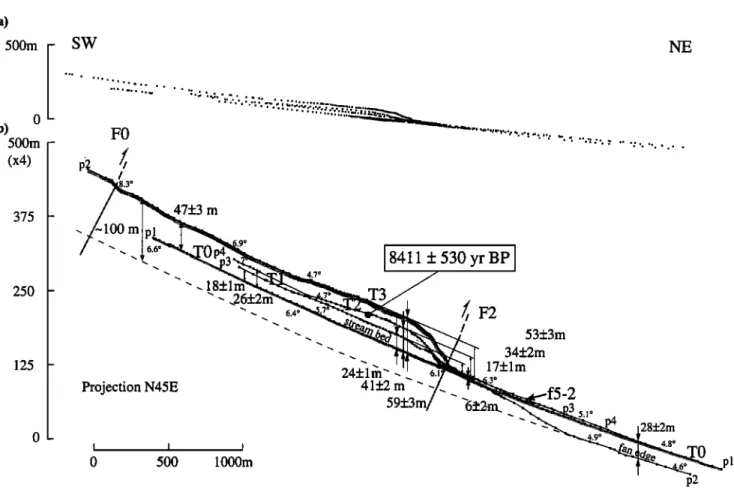
2.3.1. Site 1. Site 1 is located where stream r5
cuts F2, about midway
along
the ledge
(Plate 1 and
Figures
3b, 8, and 9). As most of the streams
that
cross
the frontal
thrust,
r5 has
deeply
incised
the highest
terrace
level (T3). T3 is a meters-thick
conglomerate
layer,
unconformable
on 200-500
south
dipping
red beds
and topped by I to 2 m of loess. Further entrenchment
of r5 has
left two principal
inset
terraces
below
T3 (T2,
T1; Figures
3 and 8). The minimum
height
of T3 above
the present-day
streambed
(TO, profile
pl, Figure
9) is
47 + 3 m, and its highest reach, just south of the frontal
flexural
scarp
(F2), is 59 + 3 m (profile
p2, Figure
9,
Table 1). T2 is reduced
to isolated
tongues
separated
by T1 channels.
The two northernmost
tongues
form
VAN DER WOERD ET AL.' THRUSTING ALONG TANGHE NAN SHAN, CHINA 30,487
crest
500 m
. ;i'
8411
:!:530
yr BP
:!
Figure 8. (a) Site 1. Enlargement of SPOT image KJ236-271. (b) Geomorphic interpretation of image in Figure 8a. Solid dots indicate topographic levelling points along profiles p l to p4
across terrace levels T1, T2, T3 and stream rS.
elongated, teardrop-shaped hills just south of F2, which truncates them at their widest (Figures 3a and 8), a pattern characteristic of progressive folding of terraces across active drainages [e.g., Meyer, 1•1; Meyer et al., 1•8]. The minimum height ofT2 above TO is 2•4-2 m, and its highest reach, 41 -F 2 m, again just south of F2
(profile
p4, Figures
8 and •). T1 forms
a longer
tongue,
18-I-1 m to 24-I-1 m above TO (profile p3, Figures 8 and •). It is also highest immediately south of F2.Projection of the profiles on a vertical plane striking N45øE, perpendicular to F2 (Figure •), indicates that T1, T2, and T3 are fairly uniformly uplifted between
F0 and F2. At a more detailed level, the three pro-
files are deformed by a slight synclinal sag whose hinge
lies about midway between F0 and F2 and by an asym-
metric, north-vergent anticline whose hinge lies ,-,200
m south of the trace of F2. The terraces thus out-
line a 1200- to 1400-m-wide bulge south of the main piedmont thrust. The shapes of their warped surfaces may be used to infer the geometry of the underlying thrust ramp. The nonuniform uplift pattern implies a northward increase in thrust dip. More specifically, F2 probably shallows about 1.3 km south of the cumulative
scarp, at a depth also of the order of 1.3 km (Figure 7) [e.g., Meyer et al., 1998].
A better assessment of the uplift requires constraints
on incision by r5. The downstream decrease in slope
(from 6.60 to 6.10 ) of the stream profile, which is reg-
ularly concave upward, and the steeper slope of T3, which decreases from 8.30 to 6.90 north of F0, may
30,488 VAN DER WOERD ET AL.' THRUSTING ALONG TANGHE NAN SHAN, CHINA (a) 500m 0 500m (x4) 375 250 125 SW 47+3 rn Projection N45E '-I I I I 0 500 1000m 4.7 ø
8411
+ 530
yr
BPI
.26+2i''.
6'4o
•// F2
- / 24+1fn' 41+2 rn '- 59+3m 53ñ3m 34ñ2m 17ñlm .3 -2 plFigure 9. Projection
N45øE
of profiles
at site 1' (a) lxl scale;
(b) projection
with vertical
exaggeration (x4). Slopes and heights of terraces above streambed and footwall are indicated.
Plausible
total offset
of T3 inferred
from
fan slope
variation
in piedmont
may reach
~100 rn (see
text).
be taken to suggest that the stream gradient changed throughout deposition and folding of the terraces (Fig- ure 9). Although slope differences between the terrace
and the river are small (0.50 to 1.7ø), a 10 slope
vari-
ation across a 3000-m-long profile would suffice to ac- count for ~50 m of differential incision. Even if r5 had a steeper slope at the time T3 was deposited, however, the maximum height of the folded terraces relative to
footwall bajada profiles north of F2 would not change much. Furthermore, r5 keeps depositing alluvium in
its footwall fan, burying the T3 fanglomerates, which
leads
to an underestimate,
probably
by 40% (Figure
9),
of the actual vertical offset of T3 by F2. The heightdifference
between
the streambed
profile (p l) and the
projection of the distal part of the profile levelled at the
western edge of the footwall fan (p2) (Figure 9), where
they have similar slopes, reaches 30 m. The thickness
of the footwall fan deposited by r5 on top of T3 might
be comparable. In any event, relative to the top surface
of present deposits on the footwall just north of F2, the
minimum vertical offsets of the three terraces (T3, T2, and T1) by the piedmont thrust are 53 4-3 m, 34 + 2
m, and 17 q- I m, respectively
(Figure 9 and Table 1).
Carbon 14 ages were obtained from organic material retrieved by refreshing a steep face cut by a small regres- sive gully, at the base of the loess manfling the highest
reach
of T2 (Figure
8 and profile
p4 in Figure
9). A bed
of angular, poorly sorted clasts of mostly dark green metamorphic Paleozoic schist lies at a depth of 1.3 m
under the rather homogeneous loess layer. Just above
this uppermost, fluvial T2 deposit, we collected small
pieces of black-brown organic matter mixed with loess,
probably associated with soil formation after the ter- race was abandoned by the river. Three samples weigh- ing less than I mg yielded ages of 8330 q- 220, 8395 q- 75,
and 9485 q- 485 years B.P. (top in Table 2). The ratio between the minimum throw of T2 across F2 (344-2 m) and the weighted mean of these three ages (8411 q- 530 years B.P., top in Table 2) provides a minimum vertical uplift rate of 4.1 q- 0.5 mm/yr for this terrace during
the later part of the Holocene. If this rate had re-
mained constant between the Last Glacial Maximum
(LGM)(~20 ka) and the present, the ages of T3 and
T1 would be 14390 q- 3200 years B.P. and 5850 q- 1000 years B.P., respectively. If the dip of the main piedmont thrust ramp F2 were less than 45øS, then the shorten-
ing rate across the north flank of the Tanghe Nan Shan
range would significantly exceed 4 mm/yr.
2.3.2. Site 2. Site 2 is located where the surface traces of thrusts F2 and F3 meet the most active strike-
slip strand of the Altyn Tagh Fault (Plate I and Figure 10). The thrusts have produced uplift and folding of
VAN DER WOERD ET AL.' THRUSTING ALONG TANGHE NAN SHAN, CHINA 30,489
Table 1. Heights of Terraces Above Streambeds
and Vertical Throws Across Main Thrusts
Terrace Profile Height, Vertical Throw, m Seismic Scarp m F2 F3 Height, m Site 1 T1 p3 24 4- 1 17 4- 1 T2 p5 41 4- 2 34 4- 2 T3 p2 59 4- 3 53 4- 3 Site 2 TO p4 1.1 ... TO p4 4.5 ... T1 p4 13.3 ... T•2 p4 31.0 ... T"2 p4 36.2 ... Tin2 p7 ... 3 4- 1 T"3 p4 45.4 ... Tin3 p4 47.9 ... Tin3 p10 ... 15 4- 3 ... T"•3 p9 ... 14 4- 3 11 4- 3 Site 3 TO p9 1.3 ß ß ß T1 p10 ... T1 p5 4.5 ß ß ß T1 p13 ... T1 p12 ... mean T•I p3 ... T•I p2 ... T•I pl ... mean T2 p3 ... T2 p8 18.1 ß .. mean T•2 p7 ... T•2 p2 ... ß . ß 2.3 3.3 2.6 . , , 3.0 4-0.3 4.2 4.6 4.5 4.5 4- 0.5 14.8 14.6 14.7 4- 0.1 22.4 17.1 . , . 0.9 1.6 1.4 1.6 1.5 4-0.1 0.7- 1.9 1.5- 2.9 1.1- 2.1
now abandoned terraces north of the present channel
of Xishui Gou (rS) (Figure 10). North of the thrusts,
the Altyn Tagh Fault is marked by a continuous, northfacing
scarp
across
recent
fans (Figure 10).
The terraces and fans form a set of hanging, inset
tongues
of fluvial alluvium,
which could
only have been
emplaced by the Xishui Gou stream before its course was deviated eastward into its present channel (Plate 1and Figures
2 and 10). The fans are left laterally offset
Table 3. Model Age of Terraces at Site 2
Terrace Height Above Model Age, Stream, m years TO 1.1 4- 0.2 380 4- 50 T'0 4.5 4- 0.2 1150 4- 230 T1 13.3 4- 0.5 4582 4- 143 • Tt2 31.0 4- 2.0 7442 4- 340 T"2 36.2 4- 2.0 9235 4- 130 • T"3 45.4 4- 2.5 12400 4- 540 Tin3 47.9 4- 2.5 13270 4- 400
•Terrace directly dated with radiocarbon.
several tens to hundreds of meters by the fault [Van der Woerd, 1998]. Four main terrace levels (T1 to T4), each
divided into sublevels, form a total of 10 distinct sur-
faces. All are conglomeratic strath terraces cut into the
steeply dipping, Oligocene-Miocene red beds as at site
1. Almost all the terraces are covered with a loess layer
whose thickness increases with height above the present
streambed, attesting to successive abandonment during
incision, and final entrenchment of r8 into its present
channel. The inset arrangement of the terraces and the
pattern of smaller rills on their surfaces confirm that
they were deposited by a fairly large, more northerly
flowing stream (N2øE to N30øE, Figure 10). Such a flow
direction is that of r8 upstream, before it bends sharply
eastward just south of the site. The now beheaded and
hanging terraces, deposited by r8, were thus probably
abandoned while the stream incised deeper toward the
east, as a consequence of capture by a smaller stream
whose headward retreat was driven by thrusting and
iblding. The more recent levels (T•0, T1, Figure 11)
were emplaced along the N70øE trending present chan- nel, after r8 abandoned T"2, the last north directed
30,490
VAN DER WOERD
ET AL.' THRUSTING
ALONG
TANGHE
NAN SHAN,
CHINA
.. .,•..:•. .:,'• ..•.,• ;,•.::,•,. .;'.- . • .•'•'• ,.• ... ..•, : •.. .•-.-
'. • F'"• :"-•; •.j-?•-
..
.'-" '.'Y : .' :'•.,.:,•:?. ...., ..
.'-'n:: , '•' •-'.-:....:;• •?•.•
• :-' :' • e-•:•.:'..:.. • .. •' : . :'..;:': . .:::..-:: .:. :-•.'-:. .... •: (: .. :• •.•...
:--:•
:..•..::
...
:..•---.--•-/..•. ...
- ...•:
• ...,-•/• :'•.
.--: .. • '.%..-• .... -.- :...:•-•-- .... :.:. ... : .. :.:::•- • ..•: :.--•:.• :-• • ..•' ... .-•... • ... . ... •.•..• ... :• ... ..•.... .• •;• •-: - •% ' "- .., .•..: ".•: • ,.'•..-'.". '.:...<..-' ' ,..::'.. 'L ... ' • • •...
•:•-•:, . .•.•.;:.-.,,..v.
•:
...
....•-•--•
'• .:- ,.•.-'•
. •-•
•
••'?• ß, •. •....' • . ...,..• ..• ., :. ?•..?• .•. .. .. -::..•.>• ..;•. -.%>::.:::...•. •.•.-- ., •,-•. •._• ... •.' ... .,.•...-. •. ...-- ..:•,• •.-• >: •.•.:.. ' :- .:::•:• .•::•:.• ... ..• -.•...--.•.• . ...: -•..-...• . •. .•:-•?•.. •.•.•.•.•. -• .::-.. • . ." •.•.. •..- ...:?-':.::- •--:>• ... - ... . ... . ... . , • • .. ,. • •.. • •..- .... ...:-- •...- ... >•.•-•'. •...- ..•.•..:...:%..?•,, ...•.• : • • •" • ..• .•::..:• •.•-.-•.• • '• .... .•::...?--- •..•...•: ... .. ,• ... ..•"-•....•. •:--...:.:. ::•.:'•.• ..• •-•:.. .•••-••••.••••••••••• •" •... ...--.. . .•.:. •..•.'• '-.•..• ... ... •..• . • .:. ... :• .... .•... •::..• ... •.---..: • .... '• .•.-•'• .. . • ... • ... :•.•;•.:• .... --w'."• •.•:•:•...'.-•:• ,,..•.•.::•.-'-.•.•'•:.-,•.•::• •-•-.•-' • : •-•--• • • •:•:• ... • •x•..•-•. •;-- -': • •"•-::•"•'•'•' ... :•-•-..•-• .- -• •-•7"•- -•'•.':. "."'.'• :":':"-• •-• • • • v • •.'•...• •>• ... • :' :.•' '"•....
•... • •--•
•.•:•.
. • • • .• . : •.• • •:'? .• •. .• • • . ... •'" •'t ..• -• ... •-...:.;.•, ... • •: -::. ...•.:.. .; . ... ,..:.: - ... • ..• :'•"• •;>• -• ,:•.. ... .t?•::• •-.-•:. • .;*:;• : ... ... ...:.-•..? •: ... •._• ....: .•...::•:-• • -. . , ':•0•.'•-• ... .... •:- .•.--'-• .•-•---•...-•:•: -•':• . •:• ::.::>::;C:•:-.:?•'•, -../• .• .•---.•-v?- • ..:•.:.•:•?- •:--:•..:,.• • ... :•..• • ... :•.-...,. ':•;", ??-•' y:• ... •...• •'-' • •'? •:>•-:..-'->'• .:.: .. ... .":'< ' ' ".': ..• ... •. . • •.• .-•. • '....
.
:•=_. river • riser•
strike
slip
'•
...
T2 :,•>:•
T4
• reveme
Folded
md
bed
_• T1 •
...
T3
• normal
basement
_• TO ....
Figure 10. (a) Enlargement
of SPOT
image
KJ236-271
of site
2. (b) Geomorphic
interpretation
of white
rectangle
in Figure
10a. Solid
dots
are topographic
profile
points.
Large
white
dots
are
sampling
sites
for radiocarbon
dating.
Terrace
chronology
and slope
directions
suggest
deviation
of stream
r8 from
N to NE (T3 to T2) and then
capture
into present-day
channel
(from
NE to
approximately E-W).
Total station
profile
p4 (Figure
11) shows
the heights
of the principal
terraces
above
the present-day
streambed
(Table 1). The ages
(4582
:k 172 years
B.P. and 9235
:k
130 years
B.P.; Table 3) of two of the terraces
(T1 and
T•2, respectively)
were determined
by 14C dating of
charcoal and organic material sampled just above the
limit between pebbles and overlying loess in pits and
trenches dug on top of the terrace surfaces (Table 2).
The ratios between the height above the present-day
streambed and the age of these two terraces (2.9 q-0.2 mm/yr and 4.9 :k 0.2 mm/yr for T1 and Tit2, respec- tively) reflect a marked difference in incision rate. This
VAN DER WOERD ET AL.: THRUSTING ALONG TANGHE NAN SHAN, CHINA 30,491
SE
NW
(b)
SE
NW
Projection
N145
T"3 2.5
rn
T"'3 50m
(x4)47.9
m 45.4m
....
22.6
m
5,
ø
36,2
m
/31
ø '
9235•
o o.., T..! .... ./ " r8 13.',i I I T O "'•'l/•" '1
4582---172r
BP
30yr
BP]
p4 25 stream bed 0 0 1 O0 200mFigure 11. (a) View, to the west, at site 2, of abandoned terrace flight above entrenched streambed r8. (b) Profile p4 across terraces and relative heights.
suggests that capture occurred between the emplace-
ment of T•2 and T1, as implied by the great height
(17.4 m) of the T//1/T1 riser (Figure
11), with a mean
incision rate prior to capture comparable to that since
abandonment of T1 (Figure 12). Capture would have instantaneously lowered the base level of the stream, in- creasing greatly, but briefly, the incision rate, possibly around 5500 years B.P.. Following this scenario, and despite the uncertainty in the timing of capture, it is
possible
to infer the ages
of the other
terraces
(Table 3),
which would range from 380-t-50 years for TO, 1550-t-230years for T/0, 7440 q- 340 years for T/2, 12,400 q- 540
years
for T"3, and 13,270
q- 400 years
for T"/3 (Figure
12).From profiles p10 and p9, the vertical throw of T"/3 appears to be about 14 q- 3 m across F/2 and about 11 q- 3 m across F3 (Figure 13). The latter throw may
be overestimated, since it includes the apparent vertical
offset due to left-lateral displacement of the sloping ter-
race surface by the Altyn Tagh Fault [Van der Woerd, 1998]. The difference between the highest level reached by T"/3 south of r8 and the level of the Tin2 fan north
of both thrusts implies that the minimum cumulative vertical throw probably exceeds --•50 m, an offset com-
parable to that ofT3 at site I (53q-3 m). Note, however,
that the strikes of F/2 and F3 are about N120øE and N85øE, 150 and 500 less, respectively, than the strike of
F2 at site I (N135øE). Such differences in strike might
account for variations in coeval shortening, hence up- lift amounts of 5% to 50%, such that the vertical throw
of T"/3 might be roughly half that at site I consistent
with the sum of the vertical throws of T/"3 across both
F3 and F/2 along profile p9 (25 q- 6 m, Figure 13). The
vertical throw of T2 across F/2 cannot be measured be- cause entrenchment of r8 has destroyed the intersection between F/2 and T2. The total throw of terrace T2 is
thus poorly constrained. Nevertheless, overall, both the ages of the terraces and the measured throws indicate a
pattern of cumulative uplift quantitatively comparable with that at site 1.
2.3.3. Site 3. At this site, about halfway between
the present outlets of r7 and r8 onto the bajada (Figure 2), five hills capped by folded fanglomerates mark the growth of a 1250-m-long and 200-m-wide anticline (A3,
30,492 VAN DER WOERD ET AL.' THRUSTING ALONG TANGHE NAN SHAN, CHINA
Table 2. Radiocarbon Dating Results at Sites 1, 2, and 3
Sample Fraction A x4 C Radiocarbon Calibrated Age, • Sample
Modern, 10 -2 Age, • years years B.P. Depth, cm
Site 1 Terrace T2 STH48c 39.01 4- 1.12 ... 7500 4- 240 8330 4- 220 STH48d 36.05 4- 0.31 -639.5 4- 3.1 8200 4- 80 9485 4- 485 STH48e 38.54 4- 0.44 -614.6 4- 4.4 7660 4- 100 8395 4- 75
Site
œ
mean: 8411
4- 530
Terrace T1 STH96a 58.86 4- 0.33 -401.4 4- 3.3 4120 4- 50 4635 4- 185 0.3 STH96b 60.99 4- 0.39 -390.2 4- 3.9 3970 4- 60 4410 4- 60 0.3 STH96c 58.97 4- 0.46 -410.3 4- 4.6 4240 4- 70 4725 4- 35 0.2 STH96d 60.01 4- 0.39 -399.9 4- 3.9 4100 4- 60 4470 4- 40 0.1Terrace
T"2
mean: 4582
4-1 72
STH83a 43.82 4- 0.37 -561.8 4- 3.7 6630 4- 70 7505 4- 25 -•1 STH83b 36.15 4- 0.21 -638.5 4- 2.1 8170 4- 50 9105 4- 105 ,,02 STH83c 35.59 4- 0.23 -644.1 4- 2.3 8300 4- 60 9280 4- 90 ,-,,2 STH83d 36.21 4- 0.21 -637.9 4- 2.1 8160 4- 50 9305 4- 105 ,,02Site
3
mean: 9235
4- 130
Terrace T•0 STH61a 90.94 4- 0.69 -90.6 4- 6.9 760 4- 70 690 4- 30 0.4 STH61b 91.34 4- 0.51 -86.6 4- 5.1 730 4- 50 670 4- 20 0.4 STH62a 97.72 4- 0.65 -22.8 4- 6.5 180 4- 60 145 4- 72 ... STH62b 91.67 4- 0.89 -83.3 4- 8.9 700 4- 80 625 4- 65 ... Terrace T1 STH64 83.45 4- 0.45 -165.5 4- 4.5 1450 4- 50 1340 4- 40 0.43 STH67a 98.59 4- 0.65 -14.1 4- 6.5 110 4- 60 135 4- 67 0.1 STH67b 90.94 4- 1.04 -90.6 4- 10.4 760 4- 100 690 4- 40 0.1 STH67c 91.10 4- 1.82 -89.0 4- 18.2 750 4- 170 715 4- 165 0.1 STH67d 86.57 4- 0.58 -134.3 4- 5.8 1160 4- 60 1070 4- 100 0.2 STH67f 86.92 4- 2.07 .-. 1130 4- 200 1025 4- 245 0.3 STH67h 80.00 4- 1.36 ... 1790 4- 140 1615 4- 95 0.2 Terrace T2 STH67g 36.11 4- 0.25 -638.9 4- 2.5 8180 4- 60 9100 4- 110 1.0 1.3 1.3 1.3•Radiocarbon age using the Libby half-life of 5588 years, an assumed 513C value of-25, and
following the conventions of Stuiver and Polach [1977].
bCalibration according to Stuiver and Reimer [1993]. Mean value between lower and upper
bound.
Figure 14). The main stream that drains the catch-
ment between r7 and r8 has abraded the central part of the anticline, depositing a younger set of terraces now folded and uplifted at different heights above the streambed. West of the easternmost stream channels, the uplifted terraces are bounded to the north by one or two recent seismic thrust scarps. East of that channel,
a slope break marks the base of a large flexure (Figure
14). The highest
terrace
levels
here (T2 and T'2) stand
14.6 and 22.4 m, respectively, above the fan north of the
slope break (profiles p8 and p7, Figure 15). West of the
main stream, two elongated terrace tongues, the highest
one with a narrow, eroded crestline perpendicular to the
fold axis, stand 14.8 and 17.1 rn above the fans north
of the thrust scarps (p2 and p3, Figure 16). These ter-
race tongues thus correlate with the levels on the east
side of the stream (Figure 14). They are surrounded by a lower level (T'i) only 4.5 rn above the northern fans
(pl, p2, and p3, Figure
16). An even
lower
terrace
level,
T1, forms an isolated tongue between the two principalchannels of the stream, 2.3 to 3.3 rn above the same level
north of the thrust scarp (p13, p5, and p10, Figure 15). The lowest terrace level (T•0), last abandoned by the
stream, stands only 1.3 rn above the streambed. It is
paved with loose surface pebbles thinly sprinkled with
loess and bears well-preserved braided channels (Figure 17). T1 has a smoother surface, with a 0.3- to 0.5-m-
thick loess cover, but is still bounded by sharp and steep
risers (Figure 17). T•i, T2, and T•2 have loess covers of increasing thickness (from 1 to 2 m) and risers eroded
by deep, regressive gullies.
Charcoal samples (STH61a and STH61b; 1, in Fig- ure 14) were retrieved in T•0 near the top of a free faced
riser, •70 cm above the streambed and •40 cm beneath
the surface (Figure 17). Such charcoal, apparently from
VAN DER WOERD ET AL' THRUSTING ALONG TANGHE NAN SHAN, CHINA 30,493 (a) 200m (x5) lOO Ill
•.
Projection
N30
p•i3
...
... _ p9-p10 p3 T"2 p4•,•l..
I
I III
,1,•TO
,2
T•i.._
'
""'•,•"'3
•-'•'
...
'-'"'• T""3
I'U
':•'%----•2.7;
...
.7'"'"'••
T"'2
Stream
e(:/
p 3'2ø
P)"•
•'•"•p13
I I I I 500 1000 1500 2000rn (b) lOO 80- 60- 40- 20-4582+172yr
BP
I
0 •" , • , I , , , , I , • , , I • , , , I , ' ' I I I I 0 5000 10000 15000 2000014
C dating
'
model
age
•,,•/"]•.
-
. ,•.9
•ø'• .
T"3 ½.---'
-
capture T"2 ..-
T"'3
-
:" T'2
9235+13øyr
BP
I
. --.t
I 25000 Age (yr BP)Figure 12. (a) Topographic profiles projected N30øE at site 2. (b) Age of terraces, inferred from incision rate assumed to be constant and two dated terraces (T1 and T//2).
,--2-m-long
sand
lens
in between
gravel
layers.
Two frag-
ments yielded similar ages of 690 5= 30 years B.P. and 670 5= 20 years B.P. (Table 2). Two other samples werefound
near the top of another
riser upstream
(2, Figure
14). Small
roots
just under
the surface
(STH62a)
and a
deeper
charcoal
(STH62b) yielded
ages
of 1455=72
years
B.P. and 6255=65 years B.P., respectively. The surface ofT/0 is thus younger
than 650 years
B.P., in agreement
with its modest
height (,-01 m) above the present-day
streambed and the braided channels still visible on it.The thin loess
layer and vegetation,
however,
suggest
it
was abandoned centuries ago.On T1, samples
were
collected
in two different
places.
On the east
bank
of the western
channel
(4, Figure
14),
a free-faced riser exposes ponded T1 deposits with in-
tercalated gravel, sand, and reworked loess layers down to about 1 m upstream from a protruding T2 remnant
(Figure 18). Samples STH67a-STH67f were collected
near the top of the section, down to 0.3 m. The top-
most samples are charcoal from small bush trunks prob-
ably resulting, like STH62a, from vegetation burial by
loess accumulation and soil on the surface of the aban-
doned terrace. From deepest to shallowest, their ages
(STH67a, STH67b, STH67c) range between
715 5= 165
years B.P. and 135 5= 67 years B.P., corroborating up- ward younging of the soils (Figure 18). Gravel bedsunderneath become coatset downward and alternate
30,494 VAN DER WOERD ET AL.: THRUSTING ALONG TANGHE NAN SHAN, CHINA (a)
SW
lOOm (x4) 50Projection
N30E
NE
P1ø'"--....••,,
3
+_3m
....
_1__-_
45m
...
- ...
f
4.o Altyn
Tagh
Fault
...
i ...
...
1_+3
. , .o*m
_
ß
F3
(b)25m
(x4)p7•
0
2.8-•
•ø
F3•)
1•30
2})Om
Figure 13. (a) Projection
N30øE
of profiles
p10 and p9 across
F2 and F3 and vertical
throw
across
different
thrusts. (b) Profile p7 across
F3 on T"•2.
shallowest pebble and gravel beds (STH67d, STH67f, STH67h) have older ages of 1070+ 100, 1025+245, and
1615 q- 95 years B.P., which constrain the last episodes of fluvial deposition on T1. The age of abandonment of T1 must postdate 1615 q- 95 years B.P.. The deepest
sample (STH67g), collected I m beneath the surface in
a thin sand lens within the coarsest pebble layer, yields an age of 9100 q- 110 years B.P.. This much older sam-
ple probably
belongs
to T2, like the adjacent,
protrud-
ing coarse conglomerate remnant that locally dams theT1 deposits.
T2 is therefore
younger
than 9100 years
B.P.. A trench
dug into the loess
cover
of T1 (3, Fig-
ure 14), about 70 rn east of the western channel riser(Figure
17), yielded
another
charcoal
sample
(STH64),
0.43 m beneath the surface,
with a calibrated
age of
1340 q- 40 years B.P. (Table 2), consistent with thoseof STH67d, STH67f, STH67h. This confirms that T1
was abandoned sometime between 1300 and 1000 years
B.P..
A minimum
vertical throw rate on F3, 1.6 mm/yr
(Figure 19), can be calculated
using
the ratios
between
the minimum
vertical
offsets
(2.3 and 14.6 m, Table 1)
and the maximum ages (1340q-40 years B.P. and 9100q- 110 years B.P., Table 2) of T1 and T2, respectively. If
the vertical offset of T1 had been 3.3 m in as little as
1025 years B.P. (Tables I and 2), then the maximum throw rate on F3 would be about 3.2 mm/yr. The best
constrained vertical throw rate is that obtained by using
the offset ofT1 on p5 (3.3 m, Figure 15, Table 1) and the
age of T1 in the trench less than 20 m from that profile
(1340 years B.P.). It is 2.46 mm/yr, close to the mean between the bounds above (2.4 q- 0.8 mm/yr)(Figure 19). Assuming the thrust ramp beneath anticline A3 to dip 450 would imply a shortening rate of ,02.5 mm/yr
across F3 and this anticline.
The we!l-preserved seismic thrust scarplet (Figure 17) that cuts the T1 terrace tongue between the main
stream channels does not extend on T•0. On profiles
p13 and p5 (Figure 15a), the height of the scarplet is
1.4 to 1.6 m. On p10 (Figure 15a), it is smaller
(0.9 m),
because of lateral aggradation at its base. The scarplet
slope is still steep (--•23 ø), with no break, and thus the
--1.5-m surface offset results from only one earthquake,
predating the emplacement ofTt0, probably around 600
years ago. To the west, the scarplet continues 200 m to
merge with the higher cumulative seismic scarps that
offset T•I vertically by 4.5 rn (Figure 17). The cumula-
VAN DER WOERD ET AL' THRUSTING ALONG TANGHE NAN SHAN, CHINA 30,495 T'2 T2 T'I T1 T'0 dating sites 1: STH61 2: STH62 3: STH64 4: STH67 Co) NE Projection N40E
T2 (-15 m)
T'2 (-20 m) ,',7 P•-'-"- -r',.•
/ c:
,_• p3.
•P••p
fault
scarp
(-1.2
m)
p4
P5•
-•'• p9 ,
_
• .... •
-
p6
0
100 200m
p7 SW_ 50m (x4) 25Figure 14. (a) Geomorphic
map of site 3. Hills correspond
to anticline
A3. Note scarps
of
thrust F3 that bound A3 to the northeast. Small dots are levelling points of topographic profiles.