HAL Id: hal-01201563
https://hal.archives-ouvertes.fr/hal-01201563
Submitted on 18 Sep 2015
HAL is a multi-disciplinary open access
archive for the deposit and dissemination of
sci-entific research documents, whether they are
pub-lished or not. The documents may come from
teaching and research institutions in France or
abroad, or from public or private research centers.
L’archive ouverte pluridisciplinaire HAL, est
destinée au dépôt et à la diffusion de documents
scientifiques de niveau recherche, publiés ou non,
émanant des établissements d’enseignement et de
recherche français ou étrangers, des laboratoires
publics ou privés.
Large-scale organization of carbon dioxide discharge in
the Nepal Himalayas
Frédéric Girault, Laurent Bollinger, Mukunda Bhattarai, Bharat Prasad
Koirala, Christian France-Lanord, Sudhir Rajaure, Jérôme Gaillardet,
Monique Fort, Soma Nath Sapkota, Frédéric Perrier
To cite this version:
Frédéric Girault, Laurent Bollinger, Mukunda Bhattarai, Bharat Prasad Koirala, Christian
France-Lanord, et al.. Large-scale organization of carbon dioxide discharge in the Nepal Himalayas.
Geophys-ical Research Letters, American GeophysGeophys-ical Union, 2014, 41 (18), p.1-9. �10.1002/2014GL060873�.
�hal-01201563�
Large-scale organization of carbon dioxide
discharge in the Nepal Himalayas
Frédéric Girault1,2, Laurent Bollinger3, Mukunda Bhattarai4, Bharat Prasad Koirala4, Christian France-Lanord5, Sudhir Rajaure4, Jérôme Gaillardet1, Monique Fort6, Soma Nath Sapkota4, and Frédéric Perrier1
1
Institut de Physique du Globe de Paris, Sorbonne Paris Cité, Université Paris Diderot, CNRS UMR 7154, Paris, France,2Now at Laboratoire de Géologie, École Normale Supérieure, CNRS UMR 8538, Paris, France,3CEA, DAM, DIF, Arpajon, France,4National Seismological Centre, Department of Mines and Geology, Kathmandu, Nepal,5Centre de Recherches Pétrographiques et Géochimiques, Université de Nancy, CNRS UMR 7358, Vandoeuvre-lès-Nancy, France,6Département de Géographie, Sorbonne Paris Cité, Université Paris Diderot, CNRS UMR Prodig 8586, Paris, France
Abstract
Gaseous carbon dioxide (CO2) and radon-222 release from the ground was investigated along the Main Central Thrust zone in the Nepal Himalayas. From 2200 CO2and 900 radon-222 fluxmeasurements near 13 hot springs from western to central Nepal, we obtained total CO2and radon
discharges varying from 10 3to 1.6 mol s 1and 20 to 1600 Bq s 1, respectively. We observed a coherent organization at spatial scales of≈ 10 km in a given region: low CO2and radon discharges around Pokhara (midwestern Nepal) and in the Bhote Kosi Valley (east Nepal); low CO2 but large radon
discharges in Lower Dolpo (west Nepal); and large CO2and radon discharges in the upper Trisuli Valley
(central Nepal). A 110 km long CO2-producing segment, with high carbon isotopic ratios, suggesting
metamorphic decarbonation, is thus evidenced from 84.5°E to 85.5°E. This spatial organization could be controlled by geological heterogeneity or large Himalayan earthquakes.
1. Introduction
Convergent zones play an essential role in the global carbon dioxide (CO2) balance of the Earth [Kerrick
and Caldeira, 1998]. In addition to their role of atmospheric CO2 sink through silicate weathering [Gaillardet et al., 1999; Gaillardet and Galy, 2008; Wolff-Boenisch et al., 2009], large orogens are also the location of the production and release of CO2-richfluids [Irwin and Barnes, 1980]. Major active fault
zones appear as a complex system wherefluid circulation, crustal permeability, and possibly earthquake occurrence might be interrelated dynamically [Manning and Ingebritsen, 1999; Ingebritsen and Manning, 2010; Manga et al., 2012].
The Himalayas offer a natural laboratory where this essential coupling can be studied. High seismic activity is concentrated on a midcrustal ramp located below the Main Central Thrust (MCT) zone on the Main Himalayan Thrust accommodating the 2 cm yr 1convergence between India and Southern Tibet [Avouac, 2003; Ader et al., 2012], wherefluid occurrence might explain the high electrical conductivity observed by magnetotelluric sounding [Lemonnier et al., 1999]. Seasonal variations of seismicity [Bollinger et al., 2007] and deformation [Bettinelli et al., 2008; Chanard et al., 2014] can be related to surface hydrological forcing. Evidence of CO2release exists in the MCT zone of central Nepal. First, high alkalinity of hot springs up to
56 × 10 3mol L 1was shown to contribute from 0.5 to 25% to the total dissolved inorganic carbon (DIC) of the entire Narayani watershed [Evans et al., 2004]. Furthermore, the high carbon isotopic ratios (δ13C) of the hot springs, with values reaching +13‰, suggested a metamorphic decarbonation source at depth and a massive CO2degassing near the water table, larger than 75% in the Trisuli and Marsyandi Valleys [Becker et al.,
2008; Evans et al., 2008]. Second, explicit CO2emission from the ground was discovered near hot springs of
the Trisuli Valley, in the Syabru-Bensi hydrothermal system (SBHS) [Perrier et al., 2009], where it was found to be associated with a radon-222 signature and was subsequently mapped in detail [Girault et al., 2014], providing a valuable baseline for long-term monitoring [Girault et al., 2009]. In this paper, we present the results of systematic search and measurement of gaseous CO2release in the vicinity of other significant hot
springs from western to eastern Nepal.
PUBLICATIONS
Geophysical Research Letters
RESEARCH LETTER
10.1002/2014GL060873
Key Points:
• CO2and radonfluxes were
measured near 13 hot springs in the Nepal Himalayas • Integrated CO2discharges are
heterogeneous but coherently spatially organized • A 110 km long metamorphic CO2-producing segment is clearly defined Supporting Information: • Readme • Figure S1 • Table S1 • Table S2 Correspondence to: F. Girault, girault@biotite.ens.fr Citation:
Girault, F., L. Bollinger, M. Bhattarai, B. P. Koirala, C. France-Lanord, S. Rajaure, J. Gaillardet, M. Fort, S. N. Sapkota, and F. Perrier (2014), Large-scale organization of carbon dioxide discharge in the Nepal Himalayas, Geophys. Res. Lett., 41, doi:10.1002/2014GL060873. Received 12 JUN 2014 Accepted 29 AUG 2014 Accepted article online 2 SEP 2014
2. Description of the Sites in the MCT Zone
The 2 to 10 km thick MCT shear zone in Nepal (Figure 1), associated with the steep topographic rise of the High Himalayas, places high-grade metamorphic rocks of the Greater Himalayan Sequence over low-grade metamorphic rocks of the Lesser Himalayan Sequence [Le Fort, 1975; Upreti, 1999]. This region is also characterized by numerous hot springs [Evans et al., 2004].
In this work, we measured the diffuse CO2discharge in the vicinity of 13 of these hot springs (Table 1 and Table S1 in the supporting information). All the main hot springs along the Trisuli River in central Nepal were studied (Figure 1, inset): Timure and Chilime, Langtang, and Bharku, located north, east, and south of the SBHS, respectively. Springs located in midwestern Nepal, such as the Myagdi (Beni), Kali Gandaki (Tatopani, Narchyeng), Seti, and Marsyandi Rivers were also examined (Figure 1). This set was complemented (Figure 1) by the Kodari hot spring east of Kathmandu and two hot springs in Lower Dolpo (western Nepal) near tributaries of the Thuli Bheri River: Sulighad near Juphal airport, and Tarakot 20 km eastward.
These hydrothermal systems show various settings (Tables 1, S1, and S2). Kodari, Chilime, Beni, and Tatopani springs, with significant flow rate (>1 L s 1), are major pilgrimage and touristic sites. Sulighad, Tarakot, Timure, Bharku, and Langtang springs, with smallerflow rate (<1 L s 1), are largely preserved in natural conditions due to their remote location. SBHS, Timure, and Seti springs, with insufficient flow rate to attract much economic activity, show moderate human impacts limited to cemented basins. SBHS, Tatopani, and Chilime sites have pronounced H2S odor helpful to identify CO2degassing [Girault et al., 2009], a signature
totally lacking at Sulighad and Tarakot sites despite a similar geological context. At SBHS and Timure sites, several independent CO2discharge zones, separated by>500 m, were found.
3. Measurement Methods
At each site, a systematic experimental approach developed in the SBHS was implemented. Methods are briefly recalled here. Details are given in Girault et al. [2014].
Figure 1. Overview of sites in the Nepal Himalayas. Main Central Thrust (MCT) (brown), Main Frontal Thrust (MFT) faults (green), and highest summits (white triangles) are shown. Earthquake epicenters are taken from the 1994–2012 catalog (Nepal National Seismological Centre) [Pandey et al., 1999]. The bottom left inset shows geographical location. The top right inset shows location of sites in the upper Trisuli Valley. SBHS is the Syabru-Bensi hydrothermal system in central Nepal.
CO2and radonfluxes, expressed in g m 2d 1and Bq m 2s 1, respectively, were measured with the
accumulation chamber method. After the chamber is installed on the ground, gas concentration was monitored as a function of time, and the initial rate of increase provides a measurement of theflux. The method was tested in detail in the field, and experimental uncertainties were determined to be 5–40% for CO2flux and 8–35% for radon flux. An overall common uncertainty of 5% was
added quadratically. Mean CO2and radonfluxes in background locations without degassing were 16.6 ± 1.3 g m 2d 1and 0.10 ± 0.02 Bq m 2s 1, respectively. To obtain the total discharge, expressed in mol s 1or t d 1for CO2and Bq s 1or MBq d 1for radon, spatial integration was performed using kriging and interpolation of the availableflux data, with uncertainty varying from 10 to 60% as estimated by Monte Carlo simulations.
Sampling of gas and spring water was performed using glass tubes and copper tubes, respectively. Determination of the CO2fraction was done manometrically. Carbon isotopic ratios of CO2(δ13C, defined
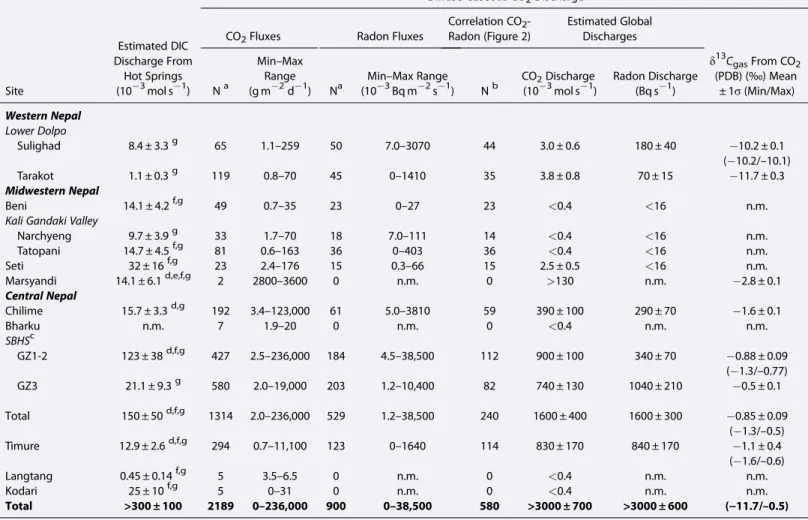
relative to the standard values of Pee Dee belemnite, PDB) were obtained by mass spectrometry. Table 1. Characteristics of CO2and Radon Emission From the Ground
Site
Estimated DIC Discharge From
Hot Springs (10 3mol s 1)
Diffuse Gaseous CO2Discharge
CO2Fluxes Radon Fluxes
Correlation CO2 -Radon (Figure 2) Estimated Global Discharges δ13C gasFrom CO2 (PDB) (‰) Mean ± 1σ (Min/Max) Na Min–Max Range (g m 2d 1) Na
Min–Max Range
(10 3Bq m 2s 1) Nb CO2Discharge (10 3mol s 1) Radon Discharge (Bq s 1) Western Nepal Lower Dolpo Sulighad 8.4 ± 3.3g 65 1.1–259 50 7.0–3070 44 3.0 ± 0.6 180 ± 40 10.2 ± 0.1 ( 10.2/–10.1) Tarakot 1.1 ± 0.3g 119 0.8–70 45 0–1410 35 3.8 ± 0.8 70 ± 15 11.7 ± 0.3 Midwestern Nepal Beni 14.1 ± 4.2f,g 49 0.7–35 23 0–27 23 <0.4 <16 n.m.
Kali Gandaki Valley
Narchyeng 9.7 ± 3.9g 33 1.7–70 18 7.0–111 14 <0.4 <16 n.m. Tatopani 14.7 ± 4.5f,g 81 0.6–163 36 0–403 36 <0.4 <16 n.m. Seti 32 ± 16f,g 23 2.4–176 15 0.3–66 15 2.5 ± 0.5 <16 n.m. Marsyandi 14.1 ± 6.1d,e,f,g 2 2800–3600 0 n.m. 0 >130 n.m. 2.8 ± 0.1 Central Nepal Chilime 15.7 ± 3.3d,g 192 3.4–123,000 61 5.0–3810 59 390 ± 100 290 ± 70 1.6 ± 0.1 Bharku n.m. 7 1.9–20 0 n.m. 0 <0.4 n.m. n.m. SBHSc GZ1-2 123 ± 38d,f,g 427 2.5–236,000 184 4.5–38,500 112 900 ± 100 340 ± 70 0.88 ± 0.09 ( 1.3/–0.77) GZ3 21.1 ± 9.3g 580 2.0–19,000 203 1.2–10,400 82 740 ± 130 1040 ± 210 0.5 ± 0.1 Total 150 ± 50d,f,g 1314 2.0–236,000 529 1.2–38,500 240 1600 ± 400 1600 ± 300 0.85 ± 0.09 ( 1.3/–0.5) Timure 12.9 ± 2.6d,f,g 294 0.7–11,100 123 0–1640 114 830 ± 170 840 ± 170 1.1 ± 0.4 ( 1.6/–0.6) Langtang 0.45 ± 0.14f,g 5 3.5–6.5 0 n.m. 0 <0.4 n.m. n.m. Kodari 25 ± 10f,g 5 0–31 0 n.m. 0 <0.4 n.m. n.m. Total >300 ± 100 2189 0–236,000 900 0–38,500 580 >3000 ± 700 >3000 ± 600 (−11.7/–0.5) aNumber of CO
2and radonflux measurements. b
Number of measurement points for CO2-radon correlation (see Figure 2). cData from the SBHS are detailed in Girault et al. [2014].
d
Data from Becker [2005].
eData from Becker et al. [2008]. f
Data from Evans et al. [2008].
gData from this study.
n.m.: not measured.
Radon concentration, expressed in Bq L 1, was systematically measured on site in hot and cold water springs by radon emanometry in air [Girault and Perrier, 2014]. Experimental uncertainties were 5–30%. Radium concentration in water, expressed in Bq L 1, was determined in a similar manner in the laboratory. Methods could not always be applied optimally, owing to several factors (electricity, permission, human impact, and lack of time). Searches were initiated in the immediate vicinity of the hot springs, assisted by infrared thermal imaging. Local people could sometimes indicate suspected gas discharge zones where lethal accidents had occurred.
4. Results
Measurements were carried out during the dry winter seasons between December 2007 and January 2011. Uncertainties correspond to one sigma standard deviation (68% confidence interval), and averages are geometric means.
4.1. CO2Flux and Integrated Discharge
A total of 2189 CO2and 900 radonfluxes were measured at 580 measurement points (Table 1 and Figure 2).
Maximum CO2fluxes of 236 ± 50 kg m 2d 1and 123 ± 25 kg m 2d 1were recorded in the SBHS and at
Chilime, respectively. Significant CO2discharges of 1.6 ± 0.4, 0.83 ± 0.17, and 0.39 ± 0.10 mol s 1were
observed at the SBHS, Timure, and Chilime sites, respectively. At Timure, significant discharge was observed despite smaller CO2fluxes (maximum of 11.1 ± 2.8 kg m 2d 1), due to a larger surface area of CO2degassing,
extending 150 m from the hot spring on an infrared image (Table S1). Significant CO2discharge is thus not a
specific feature of the SBHS but is a widespread feature of the upper Trisuli Valley in central Nepal. Figure 2. CO2flux versus radon-222 flux.
By contrast, modest CO2discharge, similar to background values, was identified southward at Bharku and
eastward at Langtang and Kodari. Similarly, in midwestern Nepal, modest CO2discharge was observed at
Tatopani. Modest CO2fluxes were also measured at all sites investigated from Beni to Seti hot springs. In
Marsyandi Valley, only two points were measured, but they gave significant flux values (mean of 3200 ± 300 g m 2d 1). In western Nepal at Sulighad and Tarakot, maximum CO2fluxes from the ground
(259 ± 22 and 70 ± 5 g m 2d 1) were significantly above local background flux of 6.5 ± 0.5 g m 2d 1, but CO2discharges are small.
To summarize, substantial CO2discharge has thus far only been detected between the Marsyandi and upper
Trisuli Valleys, i.e., along a 110 km long region of the Nepal Himalayan belt. Westward and eastward of this region, only low CO2discharge, close to background level, was identified (Figure 3).
4.2. Radon Signature of the CO2Discharge
Significant radon flux was observed in association with the CO2at all sites (Figure 2 and Table 1).
Radonfluxes >1 Bq m 2s 1, similar tofluxes in the SBHS [Girault et al., 2014], were observed at Timure and Chilime, yielding radon discharges of 840 ± 170 and 290 ± 70 Bq s 1, respectively, significant compared with the discharge in the SBHS (1600 ± 300 Bq s 1). In Dolpo, radon discharges were also significant (180 ± 40 and 70 ± 15 Bq s 1). Insignificant radon discharge, consistent with the regional background, characterized all other sites.
Figure 3. Characteristics of CO2degassing from the ground and from water along the Nepal Himalayan arc: (a) Carbon isotope ratios of gaseous CO2from the
ground and bubbles in springs, (b) carbon isotope ratios of water (dissolved inorganic carbon), (c) radon concentration in spring waters, and (d) CO2and radon
discharge from the ground (see supporting information). Data are summarized in Tables 1, S1, and S2. Epicenter and rupture lengths of the last significant earth-quakes are displayed: the megaearth-quakes of 1505 (M≥ 8) [Ambraseys and Jackson, 2003] and 1934 (Mw8.2) [Ambraseys and Douglas, 2004; Sapkota et al., 2013], and the
intermediate earthquakes of 1833 (Mw7.3), 1866 (Mw7.2), and 1936 (Mw7.0) [Gutenberg and Richter, 1949; Szeliga et al., 2010].
The relationship between radonflux and CO2flux varied from site to site (Figures 2
and 3). For example, the case of Dolpo (Sulighad and Tarakot) is conspicuously different, with maximum radonflux reaching 3.1 ± 0.6 and
1.4 ± 0.2 Bq m 2s 1, similar tofluxes measured in central Nepal, while the CO2
flux is relatively low. We therefore propose a classification of the sites based on CO2and radonflux data: a first group
(group I) with large CO2and radon
discharges (upper Trisuli Valley including SBHS, Timure, and Chilime, possibly Marsyandi); a second group (group II) with low CO2discharge but large radon
discharge (Sulighad and Tarakot in Lower Dolpo); and a third group (group III) with low CO2and radon discharges (Langtang and Bharku in central Nepal, Kodari to the east, Tatopani, Narchyeng, Beni, and Seti in midwestern Nepal). We did not observe a case of large CO2discharge with low radon discharge.
Values of radon concentration in the hot springs confirm this organization (Figure 3 and Table S2): large in Dolpo (205 ± 10 and 33 ± 2 Bq L 1), but small in the hot springs of midwestern and central Nepal
(0.70 ± 0.18 Bq L 1at Marsyandi, 3.8 ± 0.2 Bq L 1at Chilime, from 0.7 ± 0.1 to 19 ± 1 Bq L 1in the SBHS, from 5.8 ± 0.4 to 12 ± 4 Bq L 1at Timure, and 0.90 ± 0.09 Bq L 1at Kodari). Except at Langtang and Kodari, radon concentration in water was high when CO2discharge was insignificant and low in the presence of large
CO2discharge.
4.3. Carbon Isotopic Anomalies
In central Nepal, gaseous CO2samples showedδ13C between 1.6 ± 0.1 and 0.5 ± 0.1‰ (mean of 1.2 ± 0.2‰), consistent with previous data which support the concept of a deep metamorphic decarbonation source [Becker et al., 2008; Evans et al., 2008; Perrier et al., 2009]. In Dolpo, similarδ13C are obtained at both sites, 10.2 ± 0.1 and 11.7 ± 0.3‰, intermediate values between the mean δ13C of central Nepal and that of biogenic carbon ( 25 ± 5‰) [Cerling, 1984].
A synthesis of available values ofδ13CDICfor the dissolved inorganic carbon in hot springs is given in Figure 3
and Table S2. Compared with theδ13C of gas, there was a larger dispersion ofδ13CDICin water along the Nepal Himalayan belt, ranging from 13.8 to +13.2‰. The largest average values were observed in the Marsyandi (12.5‰) [Becker et al., 2008] and upper Trisuli Valleys (12.3 ± 0.7‰) [Becker, 2005; Evans et al., 2008].
5. Discussion
We divide the studied sites into three groups, on the basis of CO2and radon data (Figures 3 and S1). These
must reflect source and transport processes, and a preliminary interpretation is proposed below. In the hydrothermal model of Becker et al. [2008] and Evans et al. [2008], metamorphic reactions at 10–20 km depth produce CO2which percolates through fracture networks, reaching the MCT fault system, where it mixes with
meteoric water which eventually is discharged at 60–80°C at the surface. At or near the water table, CO2may
interact with the atmosphere and degas, enhancing the remnantδ13CDIC. The simplest model for the radon
signature is degassing of the radon contained in water [Girault and Perrier, 2014]. This model predicts a relationship between radon and CO2discharge (Figure S1). For some sites (group II), the radon signature can be accounted for by a small amount of degassing of radon-rich hydrothermal water. By contrast, even when a broad range of conditions are considered (gray band), this model cannot account for the largest CO2and
radon discharges observed at group I sites Timure and SBHS. The Chilime site appears here intermediate, marginally compatible with simple degassing of radon-bearing water. This analysis indicates that group I is Figure 4. Surface area versus estimated total CO2degassing from the
ground for our sites together with other selected sites (see review in Girault et al. [2014]). Solid lines are power law bestfits: black line for volcanic sites and gray line for fault-related sites.
anomalous and signals the presence of another mechanism, with radon being incorporated at a depth after CO2is degassed from water or perhaps suggesting that CO2is transported and released independently from
hydrothermal circulations [Girault and Perrier, 2014]. Differences in the radonflux can be accounted for by different depths of CO2degassing or by variations in the effective radium concentration of rocks (i.e., the radon source term) [Girault et al., 2012; Girault and Perrier, 2014, Figure 14].
In a given region, sites separated by 5–10 km showed remarkably similar characteristics, suggesting that local topography and hydrology are not major factors controlling the CO2heterogeneity. Instead, this
consistency indicates a CO2source depth of the same typical spatial scale (5 to 10 km). The similarδ13C of 1.6 ± 0.4‰ points indeed the same CO2source, most likely metamorphic decarbonation, over the Nepal
Himalayan belt. However, CO2emission is modulated along the arc. Indeed, a 110 km long region (Figure 3), which here coincides with group I, showed large CO2and radon discharges where hot springs yielded
δ13
CDIC> 10‰. Outside this region, CO2discharge was low, and hot springs gaveδ13CDIC< 4‰.
Numerous factors might control this large-scale heterogeneity. First, the CO2production rate must strongly
depend on the available rock material (e.g., the thickness of Greater Himalayan Sequence units), lateral lithology (e.g., along strike changes in lithology, or the lithology of Lesser Himalayan Sequence units), temperature distribution, and other rheological factors associated with MCT activity. Second, the midcrust permeability must affect the CO2discharge. A more detailed petrological modeling of the metamorphic
reactions [Groppo et al., 2013] is however necessary before the role of permeability can be assessed. Alternative mechanisms for CO2production involving sulfuric acid [Torres et al., 2014] may also need to be considered in this case.
The spatial organization of the CO2emissions may be discussed also in relation with the distribution of
earthquakes. Group II is located in the section of the MCT which shows the least seismic activity over the 1994–2012 time period. This is also (Figure 3) the region covered by the rupture of the large earthquake (M≥ 8) of 1505. The eastern group III section is approximately bordered to the east by the 220 km long rupture of the 1934 Mw8.2 Bihar Nepal earthquake [Sapkota et al., 2013; Bollinger et al., 2014], a region where
no hot springs are reported. Group I, by contrast, is located in the seismic gap (Figure 3) between the two 1505 and 1934 earthquakes, with smaller major earthquakes (7≤ Mw≤ 8) which have only partially released
the accumulated slip deficit since 1505. These relations are unlikely to be coincidental, as Himalayan megaquakes must have a dramatic effect on the large-scale crustal permeability, but the current data are not sufficient to substantiate hypotheses at this stage.
The systems presented in this study are among thefirst examples of degassing in an active orogen away from volcanic activity. Tofirst order, we can characterize the CO2emission by the value of the discharge and the
area of the emission, defined as the area with flux larger than 500 g m 2d 1. In Figure 4, we compare these two parameters for our sites with more familiar instances of mofette sites and a selection of volcanic and hydrothermal sites (reviewed in Girault et al. [2014]). The points of group I (SBHS, Timure, and Chilime) with significant discharge over a comparatively small surface area fall at the lower edge of the trend of volcanic and hydrothermal sites. Points of this group therefore are not fundamentally different from volcanic sites, and we can name them“tectonic fumaroles.” The contribution of such features, over all active orogens and convergent margins, might not be insignificant compared with active volcanoes. Group II (Sulighad and Tarakot) by contrast, are outside this trend but could be considered as extending the trend of points from major faults.
6. Conclusions
Diffuse CO2emissions in the Nepal Himalayas have a remarkably uniform isotopic signature. The
accompanying radon signature varies from site to site but shows coherent spatial organization. Over the 350 km long Nepal Himalayan arc that we investigated, significant CO2and radon discharges appear
concentrated in a 110 km long region spanning about 84.5°E to 85.5°E. We measured a total diffuse CO2
discharge thus far of 3.0 ± 0.7 mol s 1(or 11 ± 3 t d 1). This minimum estimate, dominated by three sites located in the upper Trisuli Valley in central Nepal, is larger than the contribution from dissolved inorganic carbon in hot springs (<0.5 mol s 1). This direct observation confirms previous inference [Becker et al., 2008; Evans et al., 2008] that gaseous release of CO2dominates the total contribution of the Himalayas, and
Geophysical Research Letters
10.1002/2014GL060873
this may also be the case in other active orogens. The observed heterogeneity, however, makes extrapolation to a whole chain from a few sites particularly difficult.
This study can only be considered afirst step toward obtaining a reliable estimate of CO2release by the
Himalayas. Degassing has not yet been studied in large areas of the Nepal Himalayas, including the far western region characterized by an intense seismic activity (Figure 1) and the eastern region East from Makalu. No CO2emissions have been measured so far in India, Bhutan, or Pakistan. In western Nepal, the
region from Marsyandi Valley to Ganesh Himal deserves more detailed mapping. Furthermore, we have sometimes observed degassing away from the hot springs along the MCT, at Timure or in the SBHS, for example, and our ability to measure large CO2fluxes was due to the use of infrared images or an
element of luck.
The origin of the CO2released in the Nepal Himalayas, while likely metamorphic, remains insufficiently
constrained. A better understanding of the source, including petrological [Groppo et al., 2013] and
thermomechanical modeling [Bollinger et al., 2006], is mandatory before transport properties of the MCT zone can be assessed. The spatial distribution of our data suggests that in the future some attention should definitely be given to relationships between CO2emissions, deformation, and Himalayan earthquakes. The
presence of different types of diffuse CO2emissions makes the Himalayas a unique natural laboratory where,
for example, a dynamic connection between crust permeability and the earthquake cycle [Ingebritsen et al., 2006] can be studied. Such working hypotheses may have important consequences in terms of coseismic or preseismic gas bursts.
References
Ader, T., et al. (2012), Convergence rate across the Nepal Himalaya and interseismic coupling on the Main Himalayan Thrust: Implications for seismic hazard, J. Geophys. Res., 117, B04403, doi:10.1029/2011JB009071.
Ambraseys, N. N., and D. Jackson (2003), A note on early earthquakes in northern India and southern Tibet, Curr. Sci. India, 84, 570–582. Ambraseys, N. N., and J. Douglas (2004), Magnitude calibration of north Indian earthquakes, Geophys. J. Int., 159(1), 165–206. Avouac, J.-P. (2003), Mountain building, erosion, and the seismic cycle in the Nepal Himalaya, Adv. Geophys., 46, 1–80.
Becker, J. A. (2005), Quantification of Himalayan metamorphic CO2fluxes: Impact on global carbon budgets, PhD thesis, Univ. of Cambridge,
Cambridge, U. K.
Becker, J. A., M. J. Bickle, A. Galy, and T. J. B. Holland (2008), Himalayan metamorphic CO2fluxes: Quantitative constraints from hydrothermal
springs, Earth Planet. Sci. Lett., 265, 616–629.
Bettinelli, P., J.-P. Avouac, M. Flouzat, L. Bollinger, G. Ramillien, S. Rajaure, and S. Sapkota (2008), Seasonal variations of seismicity and geodetic strain in the Himalaya induced by surface hydrology, Earth Planet. Sci. Lett., 266, 332–344.
Bollinger, L., P. Henry, and J.-P. Avouac (2006), Mountain building in the Nepal Himalaya: Thermal and kinematic model, Earth Planet. Sci. Lett., 244, 58–71.
Bollinger, L., F. Perrier, J.-P. Avouac, S. Sapkota, U. Gautam, and D. R. Tiwari (2007), Seasonal modulation of seismicity in the Himalaya of Nepal, Geophys. Res. Lett., 34, L08304, doi:10.1029/2006GL029192.
Bollinger, L., S. N. Sapkota, P. Tapponnier, Y. Klinger, M. Rizza, J. Van der Woerd, D. R. Tiwari, and R. Pandey (2014), Estimating the return times of great Himalayan earthquakes in Eastern Nepal: Evidence from the Patu and Bardibas strands of the Main Frontal Thrust, J. Geophys. Res. Solid Earth, doi:10.1002/2014JB010970.
Cerling, T. E. (1984), The stable isotope composition of modern soil carbonate and its relationship to climate, Earth Planet. Sci. Lett., 71, 229–240.
Chanard, K., J.-P. Avouac, G. Ramilien, and J. Genrich (2014), Modeling deformation induced by seasonal variations of continental water in the Himalaya region: Sensitivity to Earth elastic structure, J. Geophys. Res. Solid Earth, 119, 5097–5113, doi:10.1002/2013JB010451. Evans, M. J., L. A. Derry, and C. France-Lanord (2004), Geothermalfluxes of alkalinity in the Narayani river system of central Nepal, Geochem.
Geophys. Geosyst., 5, Q08011, doi:10.1029/2004GC000719.
Evans, M. J., L. A. Derry, and C. France-Lanord (2008), Degassing of metamorphic carbon dioxide from the Nepal Himalaya, Geochem. Geophys. Geosyst., 9, Q04021, doi:10.1029/2007GC001796.
Gaillardet, J., and A. Galy (2008), Himalaya—Carbon sink or source?, Science, 320, 1727–1728.
Gaillardet, J., B. Dupré, P. Louvat, and C. J. Allègre (1999), Global silicate weathering and CO2consumption rates deduced from the chemistry
of large rivers, Chem. Geol., 159, 3–30.
Girault, F., and F. Perrier (2014), The Syabru-Bensi hydrothermal system in central Nepal: 2. Modeling and significance of the radon signature, J. Geophys. Res. Solid Earth, 119, 4056–4089, doi:10.1002/2013JB010302.
Girault, F., B. P. Koirala, F. Perrier, P. Richon, and S. Rajaure (2009), Persistence of radon-222flux during monsoon at a geothermal zone in Nepal, J. Environ. Radioact., 100, 955–964.
Girault, F., F. Perrier, A. P. Gajurel, M. Bhattarai, B. P. Koirala, L. Bollinger, M. Fort, and C. France-Lanord (2012), Effective radium concentration across the Main Central Thrust in the Nepal Himalayas, Geochim. Cosmochim. Acta, 98, 203–227.
Girault, F., et al. (2014), The Syabru-Bensi hydrothermal system in central Nepal: 1. Characterization of carbon dioxide and radonfluxes, J. Geophys. Res. Solid Earth, 119, 4017–4055, doi:10.1002/2013JB010301.
Groppo, C., F. Rolfo, D. Castelli, and J. A. D. Connolly (2013), Metamorphic CO2production from calc-silicate rocks via garnet-forming
reactions in the CFAS–H2O–CO2system, Contrib. Mineral. Petrol., 166, 1655–1675.
Gutenberg, B., and C. F. Richter (1949), Seismicity of the Earth and Associated Phenomena, 295 pp., Princeton Univ. Press, Princeton, N. J. Ingebritsen, S. E., and C. E. Manning (2010), Permeability of the continental crust: Dynamic variations inferred from seismicity and
meta-morphism, Geofluids, 10, 193–205.
Geophysical Research Letters
10.1002/2014GL060873
Acknowledgments
The authors thank the Department of Mines and Geology, Kathmandu, for a fruitful and enthusiastic collaboration. This research was supported in part by CNRS-INSU. This paper has been improved, thanks to the insightful comments of the Editor, Steve Ingebritsen, and one anonymous reviewer. This is IPGP contribution 3566. The Editor thanks two anonymous reviewers for their assistance in evaluating this paper.
Ingebritsen, S. E., W. E. Sanford, and C. E. Neuzil (2006), Groundwater in Geologic Processes, 2nd ed., 536 pp., Cambridge Univ. Press, Cambridge, U. K. Irwin, W. P., and I. Barnes (1980), Tectonic relations of carbon dioxide discharges and earthquakes, J. Geophys. Res., 85(B6), 3115–3121,
doi:10.1029/JB085iB06p03115.
Kerrick, D. M., and K. Caldeira (1998), Metamorphic CO2degassing from orogenic belts, Chem. Geol., 145, 213–232.
Le Fort, P. (1975), Himalayas: Collided range, present knowledge of continental arc, Am. J. Sci., A275, 1–44.
Lemonnier, C., G. Marquis, F. Perrier, J.-P. Avouac, G. Chitrakar, B. Kafle, S. Sapkota, U. Gautam, D. Tiwari, and M. Bano (1999), Electrical structure of the Himalaya of Central Nepal: High conductivity around the mid-crustal ramp along the MHT, Geophys. Res. Lett., 26(21), 3261–3264, doi:10.1029/1999GL008363.
Manga, M., I. Beresnev, E. E. Brodsky, J. E. Elkhoury, D. Elsworth, S. E. Ingebritsen, D. C. Mays, and C.-Y. Wang (2012), Changes in permeability caused by transient stresses: Field observations, experiments, and mechanisms, Rev. Geophys., 50, RG2004, doi:10.1029/2011RG000382. Manning, C. E., and S. E. Ingebritsen (1999), Permeability of the continental crust: Implications of geothermal data and metamorphic systems,
Rev. Geophys., 37(1), 127–150, doi:10.1029/1998RG900002.
Pandey, M. R., R. P. Tandukar, J.-P. Avouac, J. Vergne, and T. Héritier (1999), Seismotectonics of the Nepal Himalaya from a local seismic network, J. Asian Earth Sci., 17, 703–712.
Perrier, F., et al. (2009), A direct evidence for high carbon dioxide and radon-222 discharge in Central Nepal, Earth Planet. Sci. Lett., 278, 198–207.
Sapkota, S. N., L. Bollinger, Y. Klinger, P. Tapponnier, Y. Gaudemer, and D. Tiwari (2013), Primary surface ruptures of the great Himalayan earthquakes in 1934 and 1255, Nat. Geosci., 6, 71–76.
Szeliga, W., S. Hough, S. Martin, and R. Bilham (2010), Intensity, magnitude, location, and attenuation in India for felt earthquakes since 1762, B. Seismol. Soc. Am., 100(2), 570–584.
Torres, M. A., A. J. West, and G. Li (2014), Sulphide oxidation and carbonate dissolution as a source of CO2over geological timescales, Nature,
507, 346–349.
Upreti, B. N. (1999), An overview of the stratigraphy and tectonics of the Nepal Himalaya, J. Asian Earth Sci., 17, 577–606.
Wolff-Boenisch, D., E. J. Gabet, D. W. Burbank, H. Langner, and J. Putkonen (2009), Spatial variations in chemical weathering and CO2
consumption in Nepalese High Himalayan catchments during the monsoon season, Geochim. Cosmochim. Acta, 73, 3148–3170.