HAL Id: halshs-01388356
https://halshs.archives-ouvertes.fr/halshs-01388356
Submitted on 26 Oct 2016
HAL is a multi-disciplinary open access
archive for the deposit and dissemination of sci-entific research documents, whether they are pub-lished or not. The documents may come from teaching and research institutions in France or abroad, or from public or private research centers.
L’archive ouverte pluridisciplinaire HAL, est destinée au dépôt et à la diffusion de documents scientifiques de niveau recherche, publiés ou non, émanant des établissements d’enseignement et de recherche français ou étrangers, des laboratoires publics ou privés.
3rd century AD revealed by a Sabaean inscription - a
view from the South
Jérémie Schiettecatte, Mounir Arbach
To cite this version:
Jérémie Schiettecatte, Mounir Arbach. The political map of Arabia and the Middle East in the 3rd century AD revealed by a Sabaean inscription - a view from the South. Arabian Archaeology and Epigraphy, Wiley, 2016, 27 (2), pp.176-196. �10.1111/aae.12071�. �halshs-01388356�
1
The political map of Arabia and the Middle East in the 3rd century AD
revealed by a Sabaean inscription — a view from the South.
Jérémie SCHIETTECATTE & Mounir ARBACH
Abstract
An inscription in Sabaic recently discovered on the site of Jabal Riyām (Yemen) gives an account of a journey — probably a diplomatic mission — carried out by a Sabaean dignitary on behalf of the rulers of the tribe of Ḥumlān. He listed the territories he passed through in western and northern Arabia and in the Middle East, up to Palmyra and Mesopotamia. This text, assumed to date back to the 3rd century AD (more probably c.260–280), provides a unique picture of the political forces in the area and throws new light on the regional map of the time.
Introduction
The accuracy of the political map of ancient Arabia varies according to the period. From the 3rd century BC to the early 2nd century AD, the outlines of the political entities interacting within the Peninsula are documented in detail in classical sources: the Geography by Eratosthenes of Cyrene (3rd century BC), by Strabo (1st century BC), and by Claudius Ptolemy (early 2nd century AD); Pliny’s Natural History and the Periplus Maris Erythraei (CASSON 1989) by an unknown author (both from the 1st century AD). From the second half of the 4th to the mid-6th century AD, a detailed picture of the political powers is provided by both the classical sources (Roman History by Ammianus Marcellinus, Church History by Philostorgius, History of the Wars by Procopius of Caesarea) and the accounts of military deeds by the kings of Ḥimyar and their vassals in the Sabaic inscriptions.
The intermediate period (mid-2nd–mid-4th century), however, did not yield any document providing us with a global view of the political landscape, and it was only by comparing various sources (Nabataean, Palmyrene, South Arabian, Ge’ez, and Latin inscriptions) that a rough sketch of a political map of Arabia could be drawn. This shaded area now emerges from obscurity thanks to the discovery by one of the present authors, in 2006, of a rare document from the ancient kingdom of Sabaʾ (Yemen), inscription Jabal Riyām 2006-17 (hereafter Riyām 2006-17). This Sabaic inscription from a temple on Jabal Riyām and dated to the 3rd century AD, is an account of a diplomatic mission of the kingdom of Sabaʾ to the northern territories. This journey takes us to Central and North Arabia, the eastern Roman territories, Syria, and as far as southern Mesopotamia.
Through its unique content, this inscription enlightens the historical geography of Arabia in the 3rd century AD and provides an overview of the tribal and political map of the region at a little-known period.
Following a short presentation of the text, the nature of each of these twelve territories will be analysed and an attempt to locate them will be proposed in order to draw the political map of Arabia and the Near East as it was at the time of this text.
A unique geographical testimony in the 3rd century
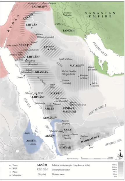
Inscription Riyām 2006-17 was discovered on the site of Jabal Riyām, Sana’a governorate, Yemen (Fig. 1).
2 Figure 1: A political map of South Arabia in the mid-3rd century AD (© J. Schiettecatte, 2015).
There, the ruins of an ancient temple dedicated to the god Taʾlab had been freshly looted and 26 misappropriated inscriptions from this deliberate damage were stored in the courtyard of a house in the village of Riyām. Sixteen texts have been dated to the 7th–4th centuries BC and were recently published (ARBACH &SCHIETTECATTE 2012). A second group comprises ten
other texts dated to the 1st–3rd century AD according to palaeographical criteria. Inscription Riyām 2006-17 is one of these (Fig. 2). The philological analysis of this inscription and the discussion regarding its dating was recently completed by the authors (ARBACH &
SCHIETTECATTE, in press) and will not be repeated here except for a few chronological
features. Inscription Riyām 2006-17 reads:
(1) [… …] (2) dedicated (to their lord) [Taʾlab Riyāmum] (3) Master of Turʿat [… …] (4)
grant them the goodwill [and the satisfaction of their lo](5)rds Yarīm Yuharḥi[b and
his sons/brothers A](6)wsallāt and Barig of the (li)[neage of Bataʿ, lords] (7) of the
palace Wakilum and h[… … their] (8) lord Taʾlab [… …] (9) and prosperous possessions
and [good harvests] (10) in their fields and their [… …] (11) plantations. And praised
Ḥay[…] (12) steward of Yarīm, Awsallāt, and Barig, the power and (13) the authority of
Taʾlab Riyāmum, as He brought him back from (14) the land of the North when his lords
dispatched him on a (diplomatic) mission (15) and he reached the land of Asdān, the
land of (16) Nizārum, the land of Tanūkh, the land of Liḥyān, (17) the land of
Tadmurum, the land of Nabaṭum, the land (18) of Rūmān, the land of Lakhmum, the
land of Gha(19)ssān, the land of Maʿaddum, the land of Ṭayyum, and the (20) land of
Khaṣāṣatān. And they entrusted (this inscription) to the protection of Taʾlab Riyām.1
1 Transcription of Riyām 2006-17: (1)[… … …] (2) (h)qnyw (s²ym-)[hmw Tʾlb Rymm] (3) bʿl Trʿt (ṯ)[… … s¹](4)
ʿd-hmw ḥẓ(y)[ w-rḍw ʾmrʾ-h](5)mw Yrm Yhrḥb [w-bny-hw ((ʾḫy-hw)) ʾ](6)ws¹lt w-Brg (b)[nw Btʿ ʾbʿl] (7) btn Wklm
w-h[… … s²ym-](8)hmw Tʾlb ʾw[... … … …](9) w-qnym hnʾm w-ʾ[fqlm ṣd](10)qm ʿdy ʿbrt-hmw w-[… h](11)mw ʾʿrs²m w-ḥmd
Ḥy[… m](12)qtwy Yrm w-ʾws¹lt w-Brg ḫyl [w]-(13)mqm Tʾlb Rymm ḥgn ʾwl-hw (14) bn ʾrḍ S²ʾmt b-kn blt-hw ʾmrʾ-(15)hmw w-ʿdw ʾrḍ ʾs¹dn w-ʾrḍ N(16)zrm w-ʾrḍ Tnḫ w-ʾrḍ Lḥyn (17) w-ʾrḍ Tdmrm w-ʾrḍ Nbṭm w-ʾ(18)rḍ Rmn w-ʾrḍ Lḫmm
3 Figure 2: Inscription Jabal Riyām 2006-17 (© J. Schiettecatte, 2006). The unknown authors of the text give thanks to Taʾlab Riyām, the main deity of the tribes of Ḥāshid and Ḥumlān in his sanctuary on the Jabal Riyām, in order to gain the favour of their lords of the lineage of Bataʿ as well as fruitful crops and harvests. They follow the common format of a dedication usually made to this deity.
There follows a more specific praise of one of the authors — whose name is only partly preserved (Ḥay[ūum] or Ḥay[ūʿathtar]) — who has returned safely from lengthy travels in the northern territories: those of the tribes of West Arabia (Asd, Nizār, Ghassān, Khaṣāṣat), North Arabia (Liḥyān, Nabaṭ, Ṭayyiʾ), Central Arabia (Maʿadd), the Euphrates valley (Tanūkh), and the Near East (Lakhm, Tadmur/Palmyra, Eastern Provinces of the Roman Empire). This expedition was undertaken on behalf of his lords Yarīm Yuharḥib, Awsallāt, and Barig of the
4 lineage of Bataʿ, princes of one of the main Sabaean tribe, Ḥumlān, a faction of the tribal confederacy of Samʿī.
Although neither king nor calendar year is given in this inscription, several clues — the palaeography, territories listed in the inscription, and names of the lords who can be identified to princes of the lineage of Bataʿ and Hamdān, leaders of the tribe of Ḥumlān and Ḥāshid — allow us to date inscription Riyām 2006-17 quite confidently sometime between AD 223 and 300 (ARBACH &SCHIETTECATTE, in press). More hypothetically, it can be dated either from
the beginning of this time span (c.225–235), when the rapid succession of several royal dynasties on the Sabaean throne made it possible for the lords of Bataʿ and Hamdān to become emancipated and dispatch a diplomatic mission, or — more probably — at the very end of the existence of the Sabaean kingdom (c.260–280), when the lords of Bataʿ and Hamdān conducted an armed resistance against the hostile kingdom of Ḥimyar.
A political map from the Euphrates to Yemen in the 3rd century
AD
Riyām 2006-17 mentions twelve territorial and political entities. An assessment of their political role and their relations with South Arabian kingdoms, and an examination of their location in the 3rd century make it possible to draw the outlines of a political map of the Arabian Peninsula and beyond at that time (Fig. 3).
Figure 3: A political map of Arabia and the Middle East showing the tribes and kingdoms mentioned in inscription Jabal Riyām 2006-17 (© A. Émery & J. Schiettecatte, 2015).
5
In the land of the North…
As a prelude to the list of the territories visited, an opening word indicates that the journey was carried out in the land of the North (ʾrḍ S2ʾmt). According to the context of the
inscription, the interpretation is twofold.
The first option would be to consider the ‘Land of the North’ as a political entity, a possible hypothesis as an unpublished inscription from the temple Awām in Maʾrib mentions the dispatching of two emissaries to ‘Caesar, king of the North’in AD 311.2 In this inscription,
the North (Shaʾmat) is identified as the Eastern provinces of the Roman Empire. In Riyām 2006-17 however, Romans (Rmn) are explicitly mentioned by their name in the territories
visited. We therefore consider the ‘land of the North’ as the wide area stretching north of South Arabia and encompassing the tribal territories and kingdoms listed later.
The land of Asd
The tribe of Asd (Sabaic: Asdān/Asd/al-Asd; Arabic: al-Azd) is known from the early
Christian era onwards from Sabaic and Ḥaḍramitic inscriptions.3 The latest Sabaic mention is
inscription ʿAbadān 1/16, dated to AD 360, stating that two factions of the Asd, Ṣudayyān and
Rasan, were defeated by the Ḥimyarite king.
A clue to the location of the land of Asd is provided by inscription Ja 635 where mention is made of a war led by the troops of Shaʿrum Awtar king of Sabaʾ and dhū-Raydān against the
king of Kinda and Qaḥṭān and the inhabitants of Qaryat dhāt-Kahl (present-day Qaryat al-Fāw). The battle took place ‘on the border of the territory of al-Asd, at the crossing-place by the two wells of dhū-Thumāl’.4 There are two candidates for this location:
1) the wells of al-Thamāla, 51 km north-east of Bīsha and 252 km west-north-west of Qaryat al-Fāw;5
2) Wādī Thumāla, 31 km south-east of al-Ṭāʾif. This is 500 km west-north-west of Qaryat al-Fāw, however, and it is unlikely that Sabaean troops were engaged in a fight against Kindites and inhabitants of Qaryat at such a distance from the site. The land of Asdān would thus have extended west of Bīsha, in the south-western heights of
Saudi Arabia, straddling the regions of al-Bāḥa and ʿAsīr. Their territory was probably comparable to that of the tribe of Azd Sarāt on the eve of Islam, stretching from Bīsha to the Tihāma shores, the southern limit being approximately al-Nimāṣ and the northern one the modern town of al-Bāḥa (STRENZIOK 1960: 834). It is worth noting that according to Ibn al-Kalbī, one of the main pre-Islamic deities of the Azd Sarāt — Dhū-l-Khalaṣa — had its sanctuary in Tabāla (FARIS 1952: 29; STRENZIOK 1960: 836; ROBIN 2012a: 51), c.40 km west of Bīsha and 75 km south-west of al-Thamāla.
2 MB 2004-I-123: Qys¹rm mlk S²ʾmt. Inscription presented by M. Maraqten on several occasions: 9th Rencontres
Sabéennes, Sana’a, 2004; 9ICAANE, Basel, 2014; 19th Rencontres Sabéennes, Pisa, 2015. On the latter occasion,
he corrected the reading of the date he had published incorrectly (MARAQTEN 2014: 100) from 404 Ḥimyarite era to 421 Ḥimyarite era, i.e. AD 311.
3 The earliest reference can be found in a Sabaic inscription that mentions ‘an expedition in the Land of Asd’ (YM 10703/4: mṭwt ʾrḍ ʾs¹d). This text comes from Wādī al-Shuḍayf (north of the Jawf valley, Yemen). It is dated to the 1st–2nd century AD by ROBIN &VOGT 1997: 123.
4 Inscription Ja 635/36–37: b-knf ʾrḍ (37)ʾl-ʾs¹d mgzt mwn-hn ḏ-Ṯml. It comes from the temple of Awām in Maʾrib,
and dates to the reign of Shaʿrum Awtar (c.215–225).
5 This location was proposed by Wissmann who identified the place with Tomala mentioned by Pliny (Nat. Hist., VI, 28, 154): WISSMANN 1964: 184; WISSMANN &MÜLLER 1977: 38. See also AL-SHEIBA 1987: 21. For SPRENGER (1875: 156), Tomala (var. Thomala) in Pliny can be equated with Θουμάτα of Ptolemy (Geogr. VI.7.33) located halfway between the Jawf valley (Yemen) and Mecca.
6 In the 3rd century AD, the tribe of Asd appeared as an autonomous kingdom ruled by a king (malik), and played a significant role in the South Arabian political landscape.
The rock of al-ʿUqla, near Shabwa, the place of investiture of the kings of Ḥaḍramawt in the 3rd century AD, is engraved with three inscriptions mentioning the presence of Asdites sojourning in the region.6 Among these, Ja 957 is of particular interest since the author,
ʿAmrum son of ʿAwfum the Asdite, mentions Yadaʿʾīl Bayān king of Ḥaḍramawt (c.225–255)7
as his ‘son-in-law’ or ‘ally’.8 An alliance by marriage between Yadaʿʾīl Bayān and a
noblewoman of Asd, daughter of ʿAmrum son of ʿAwfum, makes sense if we follow the
translation proposed by Pirenne of a later inscription from al-ʿUqla which reads ‘Rabbīshams nobleman of Asd, son of Yadaʿʾīl Bayān king of Ḥaḍramawt’.9 This Rabbīshams is possibly
one of the two last kings of Ḥaḍramawt (c. AD 300).10 The close proximity between the Arab
tribe of Asd and the Ḥaḍrami power is obvious.
Regarding the connections with Sabaʾ, Ilīsharaḥ Yaḥḍub king of Sabaʾ (c.235–255) sent an embassy ‘to the kings of the tribes Ghassān, al-Asd, Nizārum and Madhḥigum’;11 a few years
later, the same Ilīsharaḥ Yaḥḍub and his brother Yaʾzil Bayān dispatched a ‘mission to the kings of the north, al-Ḥārith son of Kaʿbum king of Asd, and Mālikum son of Baddāʾ king of
Kinda and Madhḥigum and some (other) Arabs’.12 In the early 4th century, another embassy
was sent by the Ḥimyarite king Shammar Yuharʿish to Mālikum son of Kaʿbum king of Asd.13
Two kings of Asd are thus known by name: al-Ḥārith son of Kaʿbum and Mālikum son of
Kaʿbum. It is unlikely they were siblings as between 50 and 70 years separates one inscription
from the other.14
Throughout the 3rd century, the tribe of Asd fostered a friendship with the Sabaean kingdom and its ally, the kingdom of Ḥaḍramawt.15 This close proximity between Asd, Sabaʾ, and
Ḥaḍramawt did not last after the annexation of the two latter kingdoms by Ḥimyar. If Shammar Yuharʿish sent a successful embassy to the king of Asd two generations later, the
6 Ja 938 + 939/3 and Ja 962/2: nisba ʾs¹dyn; Ja 957/1–2: nisba ʾs¹dyhn.
7 On the date of Yadaʿʾīl Bayān king of Ḥaḍramawt and his place in the royal succession, see A
NTONINI &ROBIN 2015: 9.
8 Sabaic ḫtn. See J
AMME 1962: 56.
9 Ja 997/1–3: Rbs²ms¹ ḫyr ʾs¹dn bn Ydʿʾl Byn mlk Ḥḍrmt. The translation is adapted from Pirenne (1990: 120). This genealogical reconstruction rules out the translation proposed by A. Jamme (1963: 59–60): “Rabbīshams, superintendent of the soldiers, son of Yadaʿʾīl Bayān, king of Ḥaḍramawt”.
10 He is mentioned as a co-regent of Sharaḥʾīl in a text dated to the reign of Shammar Yuharʿish king of Sabaʾ, dhū-Raydān, Ḥaḍramawt and Yamanat (Ja 656/11–12: S²rḥ(12)ʾl w-Rbs²ms¹m mlky Ḥḍrmwt). Since Shammar Yuharʿish bears the long title of the king of Ḥimyar, this text can be dated sometime between 300 and 312. This identification is also defended by Frantsouzoff (2015: 238, 246).
11 ZI 75: b-ʿbr ʾmlk ʾs²ʿbn Ḡs¹n w-l-ʾs¹d w-Nzrm w-Mḏḥgm.
12 CSAI’s translation of Ja 2110/7–10: b-kn hblt b-ʿbr ʾmlk s²ʾm(8)t ʾl-Ḥrṯ bn Kʿbm mlk (ʾ)s¹d (w)-Mlk(9)m bn Bd mlk
Kdt w-Mḏḥgm w-ḏ-bn (10)ʾʿrbn.
13 Sharaf 31/9–10: b-ʿbr Mlkm bn K(10)[ʿb]m mlk-l-ʾs¹d.
14 Ibn al-Kalbī’s genealogy mentions Mālik b. Kaʿb b. al-Ḥārith b. Kaʿb b. ʿAbdallah b. Mālik b. Naṣr b. al-Azd (CASKEL 1966, I: table 210). Here, Mālik b. Kaʿb is a grandson of al-Ḥārith b. Kaʿb. If it were chronologically coherent, drawing a parallel between the 3rd–4th-century testimonies and al-Kalbī’s genealogy is of course dubious.
15 Yadaʿʾīl Bayān king of Ḥaḍramawt son of Rabbīshams, of the freemen of Yuhabʾir, acceded to the throne of Ḥaḍramawt after the overthrow of Ilīʿazz Yaluṭ king of Ḥaḍramawt by the Sabaean king Shaʿrum Awtar
7 Ḥimyarites and the Yazʾanides led an expedition against the tribal factions of Asd in AD 360 (ʿAbadān 1/16).
To sum up, the tribe of Asd appears to be:
— a political entity headed by a king at least in the mid-3rd–early 4th century AD and controlling the territory west of Bīsha, today in the south-western heights of Saudi Arabia straddling the regions of al-Bāḥa and ʿAsīr;
— a long-standing ally of the Sabaeans, receiving their diplomatic missions and allowing the Sabaean army to cross their territories when they faced the kingdom of Kinda;
— a faithful ally of the Ḥaḍramawt, after the Sabaean king Shaʿrum Awtar, of the
lineage of Hamdān, dismissed Ilīʾazz Yaluṭ king of Ḥaḍramawt (c. AD 225) and promoted the accession to the throne of Yadaʿʾīl Bayān son of Rabbīshams, of the freemen of Yuhabʾir. A noblewoman of Asd would have been given to him in marriage. A child from this marriage would have kept the title of noble of Asd and possibly ascended the throne of Ḥaḍramawt, just before the kingdom was annexed.
The land of Nizār
In Arabic tradition Nizārum in Sabaic is identified as the tribe of Nizār. In Ibn al-Kalbī’s
genealogy, Nizār b. Maʿadd b. ʿAdnān is the common ancestor of most of the Arab tribes of the North (CASKEL 1966, I: table 1; 1966, II: 448; LEVI DELLA VIDA 1995).
If the historical existence of this tribe has been previously denied,16 several pre-Islamic
inscriptions have proved otherwise. The tribe of Nizār is mentioned in three Sabaic inscriptions from the mid-3rd to the mid-4th century AD (Riyām 2006-17, ZI 75, and ʿAbadān 1) and in the funerary inscription of Maraʾ-l-Qays at al-Namāra, southern Syria dated AD 328.
The location of its territory is based on very little evidence. In the Old Arabic inscription of al-Namāra, King Maraʾ-l-Qays is said to have ruled ‘the two Syrias’, Nizār and Maʿadd (see below). Kropp insisted that these tribal names are those of the eponyms of Arab tribes of the North (KROPP 1990: 77), that is, in northern and Central Arabia. A much more significant element is given in the Sabaic inscription ʿAbadān 1 (AD 360):
‘Barīlum son of [Ma]ʿ[dīkari]b participated in combat for the first time [... ...]
Maʿaddum and [... ...] the nomad tribe ʿAbdqaysān at Siyyān, at the waters of the wells of Sigah, between the Land of Nizārum and the Land of Ghassān’.17
According to this text, the wells of Sigah at Siyyān mark the border of the land of Nizār, at least in the mid-4th century. Robin recognized in these place names the wells of Sijā in the steppe area of al-Siyy, located in Central Arabia, c.330 km east-south-east of Medina and 380 km north-east of Mecca.18
16 L
EVI DELLA VIDA 1995: 84–85: ‘the term Nizār corresponds to a political ideal rather than to a historical reality (…) it is evident that we cannot speak of Nizār as a tribe which had a real historical existence’.
17 ʿAbadān 1/29: w-tbkr Brlm bn Mʿ[dkr]b [... ...] Mʿdm w-hw[...]w ʿs²rtn ʿbdqys¹n b-S¹yn ʿly mw bʾrn S¹gh bynn ʾrḍ
Nzrm w-ʾrḍ Ḡs¹n. Translation by R
OBIN &GAJDA (1994: 119) in the English version proposed by the CSAI. 18 R
OBIN 1986: 183. Thilo (1958: 89) describes Sijā as ‘Brunnen, nahe dem Ursprung eines der beiden Quellarme des W. Ğarīb/Ğerīr, südl. vom heutigen Mešāf Siǧā’;and al-Siyy as a ‘Steppe östlich vom südl. ʿAqīq, etwa der südwestliche Teil von Waǧra’ (ibid.: 92).
8 Inscriptions mentioning Nizār in the 3rd–4th century AD mirror the political role it played at that time. It was then one of the four main tribes in the area stretching from Najrān to Yathrib (present-day Medina), headed by a leader who was given the title of king (mlk) by the Sabaean authority. This is illustrated by a diplomatic mission sent by Ilīsharaḥ Yaḥḍub king of Sabaʾ and dhū-Raydān (c.235–255) ‘to the kings of the tribes Ghassān, al-Asd, Nizārum and
Madhḥigum’.19
Eighty years later, c. AD 328, the king Maraʾ-l-Qays son of ʿAmr,20 in his epitaph from
al-Namāra, bore the title of ‘king of all ʿArab who bound on the crown21 and ruled the two
Syrias and Nizārū and their kings’.22 The leader and the tribe of Nizār had then been
subjugated to a king who ruled over an area stretching from Mesopotamia to northern and Central Arabia.
In AD 360, Nizār simply appears as a territory23 the border of which is the setting of a
confrontation between the tribe of ʿAbdqaysān and the coalition of Ḥimyar, Kinda, Madhḥig, and Murād, during Ḥimyar’s military campaign against Maʿadd. At that time, Nizār could still have been part of the entity named Maʿadd. Subsequently, Nizār is no longer mentioned and one wonders whether the tribe might have been finally incorporated within Maʿadd; it would explain the filiation between Nizār and Maʿadd in the genealogy of Ibn al-Kalbī, as a memory of a forgotten past.
To sum up, the tribe of Nizār appears to be:
— a political entity headed by a ruler who is endowed with the title of king (mlk) by the Sabaean king at least in the 3rd and first half of the 4th century AD;
— a tribe spreading in the steppe, somewhere east of Mecca;
— a tribe subjugated to the rule of king Maraʾ-l-Qays who took control of a wide territory stretching from Mesopotamia to Central Arabia for an undetermined length of time.
The land of Tanūkh
Tanūkh can be easily identified as the tribe attested in the early centuries of Islam in Lower Mesopotamia and the upper Euphrates (CASKEL 1966, II: 544–545; SHAHID 2002). The tribe is also known in pre-Islamic sources from the 3rd century onwards.
Some scholars agree with the identification of the Thanouitai of Ptolemy (Geogr. VI.7.23) with Tanūkh (SPRENGER 1875: 208; WISSMANN 1964: 192–193). Ptolemy does not locate this ethnic group precisely; having listed tribes from North and Central Arabia, he just mentions that going to the south, one finds the Katanitai (Qaḥṭān) and then the Thanoutitai.
19 ZI 75: b-ʿbr ʾmlk ʾs²ʿbn Ḡs¹n w-l-ʾs¹d w-Nzrm w-Mḏḥgm. 20 Possibly the son of ʿAmr b. ʿAdī, king of Lakhm in al-Ḥīra (R
OBIN 2008: 182).
21 Louvre 205 = AO 4083/1: Mrʾlqys br ʿmrw mlk ʾl-ʿrb kl-h ḏw ʾsr ʾl-tg. The translation is Macdonald’s (F IEMA et al. 2015: 405), ‘ʿArab’ referring to an area in Mesopotamia. It is adapted from the alternative translation proposed by M. ZWETTLER (1993): ‘king of the entire territory of al-ʿArab’.
22 Louvre 205 = AO 4083/2–4: w-mlk ʾl-ʾsdyn/ʾsryn w-Nzrw w-mlwk-hm (…) w-mlk Mʿdw. Translation by Macdonald (FIEMA et al. 2015: 405). Regarding the reading of ʾl-ʾsryn or ʾl-ʾsdyn, it is uncertain since the same letter can be used for both R and D (KROPP 1990: 76). Kropp reads ʾl-ʾsdyn and translates it ‘the two tribes of Asad’ (i.e. Asd Shanūʾa and Asd ʿUmān). This hypothesis is highly unlikely for Robin, who sticks to the transcription ʾl-ʾsryn and suggests ‘the two Syrias’ (AVNER et al. 2013: 250, n. 32). This translation is also favoured by Macdonald (FIEMA et al. 2015: 405).
9 Qaḥṭān being the tribe that settled in Qaryat al-Fāw, it would thus indicate a territory somewhere in the south of Saudi Arabia, which is in contradiction with later data. The identification of the Thanouitai as Tanūkh remains questionable unless we give credence to historical traditions that speak of a migration of Tanūkh from Tihāma to the Gulf shores (SHAHID 2002: 206).
Later, inscription LPNab 41 found at Umm al-Jimāl, south of Buṣrā (Syria) mentions ‘Gadhīmat king of Tanūkh’.24 Whether at that time the territory of Tanūkh stretched across the
Syrian Desert up to Umm al-Jimāl, south of Buṣrā, cannot be ascertained as the reasons for the presence of the funerary stela of the tutor of this king of Tanūkh at that location remain unclear. A date in the mid-3rd century has been proposed for this inscription, based on questionable arguments.25 Thus, if this inscription reports the existence of a king of Tanūkh,
neither his date nor the extent of his kingdom can be inferred.
Be that is it may, it is highly likely that the tribe of Tanūkh was settled in Lower Mesopotamia by the late 3rd–early 4th century, most probably in the region of al-Ḥīra on the right bank of the Euphrates, where it is well attested in late antiquity. This location would be consistent with the Sabaic inscription Sharaf 31 (c. AD 300–312), in which an envoy of the Ḥimyarite king ‘reached Qaṭūṣif (Ctesiphon) and Kūk (Seleukia), the two Persian royal cities, and went to the land of Tanūkh’.26
From the mid-5th century onwards, the tribe of Tanūkh and its king were the target of at least two Ḥimyarite expeditions attempting to subjugate the Najd and north-east Arabia.27
In the 6th century AD, Tanūkh was still one of the most influential tribes of al-Ḥīra, together with the tribes of al-ʿIbād and al-Aḥlāf (ṬABARĪ/NÖLDEKE 1973: 24; SHAHID 2002: 206).
To sum up:
— it was a political entity headed by a king, possibly in the 3rd century and certainly in the 5th century;
— Tanūkh appears as a tribe that had settled in southern Mesopotamia at the latest at the end of the 3rd century AD. Al-Ḥīra remained the central location of the tribe until the advent of Islam.
The land of Liḥyān
The tribe of Liḥyān is attested in many Dadanitic inscriptions,28 in the expression ‘king of
Liḥyān’, at the earliest in the mid-6th century BC and until at least the mid-4th century BC
24 The inscription reads ‘This is the memorial of Fihr son of Sullay, tutor of Gadhīmat king of Tanūkh’(LPNab 41: (1)dnh npšw Fhrw (2)br Šly rbw Gdymt (3)mlk Tnḥ). Translation: MACDONALD 2015: 28–30.
25 R
OBIN (2008: 181) made the assumption that Gadhīmat king of Tanūkh mentioned in inscription LPNab 41 at Umm al-Jimāl is the king of al-Ḥīra, Jadhīma al-Abrash, mentioned in Arab tradition; the dating of his reign to the mid-3rd century rests on the association of Queen al-Zabbāʾ with Jadhīma al-Abrash in Arab tradition and the identification of this queen with Zenobia of Palmyra. Macdonald has called this hypothesis into question (MACDONALD 2015: 30).
26 Sharaf 31/11–12: w-wzʾ mẓʾ ʿdy Qṭwṣf w-Kwk m(12)mlkty Frs¹ w-ʾrḍ Tnḫ. After Müller’s translation (M
ÜLLER WW 1974: 157).
27 The first is mentioned in the Sabaic inscription al-ʿIrāfa 1, c. AD 445 (G
AJDA 2004; re-edited by ROBIN 2008: 200f.). The second is mentioned in the Sabaic inscription Maʾsal 3, c. AD 473 (Wādī Maʾsal, Central Arabia). The text reports the defeat of a king of Tanūkh.
28 F
ARÈS-DRAPEAU 2005. This corpus has been labelled ‘Dedanite’, ‘Liḥyanite’, or ‘Dédano-Liḥyanite’. Nevertheless, it seems more appropriate to qualify these texts as Dadanitic (MACDONALD 2000: 33), according to the place they mainly come from (Dadan, present-day oasis of al-ʿUlā), rather than after the specific kingdoms of Dadan or Liḥyān.
10 (ROHMER & CHARLOUX 2015: 300). Liḥyān was then a kingdom occupying the area of modern al-ʿUlā.
Outside the oasis of al-ʿUlā, south-west of Taymāʾ, four additional inscriptions in a local derivative of Imperial Aramaic were left by a certain Masʿudū king of Liḥyān29 and ‘Shahrū
king of Liḥyān’.30 The kingship of Masʿudū and Shahrū is questionable.31
In South Arabia, the tribe of Liḥyān is mentioned in a Sabaic inscription, B-L Nashq, from al-Bayḍāʾ in the Jawf valley (Yemen), and probably dating back to the very early 6th century BC.32 Its author undertook a commercial expedition in Gaza and Cyprus, and a mission for his
king ‘in the land of Dhakarum, Liḥyān, Abīʾôs and Ḥanak’.33 The name later appears on the
Minaic stela from Maʿīn in the Jawf valley (Yemen), where Minaean merchants listed their matrimonial alliances with women from cities or kingdoms located along the caravan trail. One of them married ‘Ms¹qy, free woman of Liḥyān’.34 This text is ascribed to the
5th–mid-4th century BC according to the place names mentioned (LEMAIRE 1996: 39–44).
Around the 3rd–2nd century BC, the Liḥyanites were outdone by competitive tribal groups.35
There is no further mention of them before the time of the Prophet Muḥammad, except by Pliny (Nat. Hist. VI.32.13: Lechieni), who is no doubt referring to an earlier source,36 and in
four undated Safaitic inscriptions from Syria and Jordan (see below). It is thus unexpected to find a mention of a land of Liḥyān in Riyām 2006-17.
Regarding the location of this territory, Liḥyān was established in the area of al-ʿUlā (northern Ḥijāz) and its immediate surroundings at least until the 3rd century BC (ROHMER &
CHARLOUX 2015). Subsequently, its location remains conjectural. Three hypotheses can be
put forward.
Firstly, the region of al-ʿUlā: although the kingdom of Liḥyān was brought to an end five or six centuries earlier than inscription Riyām 2006-17, a people who considered themselves to be Liḥyanites might still have been living in the surrounding area of al-ʿUlā and their land continued to be called by its former name. In this case, in Riyām 2006-17, Liḥyān was not the setting of a diplomatic meeting but a territory that was passed through, squeezed between Ghassān and Nabaṭ.
Secondly, somewhere between al-ʿUlā and Mecca: a tribe of Liḥyān, a branch of Hudhayl (CASKEL 1966, I: table 58), settled north-east of Mecca on the eve of Islam (LEVI DELLA
VIDA 1986: 769). The banū Liḥyān were then custodians of the idol of Hudhayl at a place called Ruhāṭ, the location of which is thought to be either in the environs of Yanbuʿ (Red Sea coast west of Medina), or more probably close to Mecca (RENTZ 1971: 559–560). The banū
29 At al-Khabū al-gharbī: JSNab 334 and 335; at al-Khabū al-sharqī: JSNab 337. 30 At Sarmadāʾ:
AL-THEEB 2014: 34–35.
31 R
OHMER &CHARLOUX 2015: 302: ‘Masʿūdū and Shahrū are self-proclaimed kings with doubtful ties to the historical core of the Liḥyanite kingdom. Even if we take their claim to kingship seriously, we have to bear in mind that the title of king often refers to tribal shaykhs in first-millennium BC Arabia’.
32 B
RON &LEMAIRE (2009: 19–29) assumed that the mention of a war between Chaldea and Ionia might refer to events that happened c.600 or 557 BC.
33 B-L Nashq/18–19: ʿd ʾrḍ Ḏkrm w-L(19)ḥyn w-ʾbʾs¹ w-Ḥnk.
34 Maʿīn 93B/46–47: Ms¹qy ḥrt L(47)ḥyn.
35 If it has been generally believed that the Nabataeans played a significant role in Liḥyān’s collapse, an alternative
hypothesis has been voiced recently by ROHMER &CHARLOUX (2015: 313), according to whom the emergence of the tribe of Thamūd in the region of Hegra (Madāʾin Ṣāliḥ) and Dadān (al-ʿUlā) might have followed the collapse of the Liḥyanite kingdom and preceded the settling of the Nabataeans.
36 See C
11 Liḥyān were still established in the neighbourhood of the Holy City in the 19th century, in Ḥaddāʾ and Baḥra, halfway between Jeddah and Mecca (RENTZ 1971: 559–560; ABU AL -ḤASAN 2010: 272). Consequently, at the time of Riyām 2006-17, assuming that the tribe of Liḥyān mentioned in Arab tradition is not just a namesake but represents the descendants of the pre-Christian Liḥyanites, the land of Liḥyān may have been located further south, somewhere between al-ʿUlā and Mecca.
Thirdly, in the desert fringes of northern Arabia/southern Syria: two Safaitic inscriptions from Wādī Shām (southern Syria), dated between the 1st century BC and the 4th century AD,37
relate an incursion of Liḥyanites in the area (MACDONALD et al. 1996: 458–464). At the same
time, three texts which have been discovered in north-eastern Jordan38 can be read in two
different ways: ‘the year ʿbdrb confronted the lineage group of Liḥyān’ or ‘the year ʿbdrbʾl confronted Liḥyān’, Liḥyān in this case being the name of a person (M. Macdonald, pers. com.). The two inscriptions from Wādī Shām and possibly the three from Jordan could be interpreted as evidence of Liḥyanite incursions, perhaps even a relocation of groups stemming from the tribe of Liḥyān on the desert margins of southern Syria, north-eastern Jordan, and northern Arabia in the early Christian era. This scenario would be consistent with the hypothesis that the author of Riyām 2006-17 listed the territories he visited in chronological order. Liḥyān would then be located near Tanūkh, Tadmur (Palmyra), and Nabaṭ. In this case, the land of Liḥyān would overlap that of Lakhm (see below). Such a hypothesis, however, remains flimsy considering the scanty evidence to back it up.
To sum up:
— Liḥyān was a political entity headed by a king at least from the 6th to the 4th century BC, perhaps later, and established in the oasis of al-ʿUlā in northern Ḥijāz; — it was a tribe which might have existed in the early Christian era in the same area or which might have moved from northern Ḥijāz, either to the neighbourhood of Mecca or to a region straddling southern Syria, northern Arabia, and north-eastern Jordan.
The land of Tadmur (Palmyra)
Tadmur is the ancient name for the city of Palmyra, still used in modern Arabic. Acting as a buffer zone between the Roman and Parthian empires, the city rose to economic and military prominence from the 1st century BC to the 3rd century AD (EDWELL 2008: 31–62). This growth was driven by the caravan trade between Lower Mesopotamia and the Roman province of Syria. The bulk of caravan inscriptions is ascribed to the reigns of Hadrian and Antoninus, and more particularly from AD 131 to 161, a period considered by many as the most flourishing one for the city (GAWLIKOWSKI 1996; SARTRE 2001: 844–845; GOREA
2012: 471). At that time, the Palmyrene territory reached the Euphrates valley to the north-east, stretched to modern ʿĀnah (Irak) to the north-east, to a location somewhere between Homs and Palmyra to the west, and the Syrian desert to the south (EDWELL 2008: 52; GOREA 2012: 465). Admittedly slowed down after Lucius Verus’ wars, during Septimius Severus’ Parthian wars, or during Ardashir and Shāpur’s campaigns against Rome, the Palmyrene trade remained active until Diocletian promoted Nisibis as the only authorized point of commercial exchange between the Roman and Sasanian empires, in AD 297/8 (GOREA 2012: 475). Under
the rule of Odeinath (AD 263–267) and that of his widow Zenobia with his son Wahballat (267–272), the Palmyrene territory went through an unprecedented expansion towards Mesopotamia, Anatolia, and Egypt. The emancipation of Zenobia from Roman authority was followed by the repression of Emperor Aurelian and the sack of the city. If the proposed
37 On the dating of Safaitic script, see M
ACDONALD 2000: 45.
12 dating of Riyām 2006-17 is correct, the Sabaean diplomatic mission might have taken place during one of these reigns, at a time when Palmyra had reached its greatest expansion.
Echoing the growing importance of Tadmur in the early Christian era and its prominent role in long-distance trade, four documents — besides Riyām 2006-17 — show commercial and diplomatic connections between South Arabia and Palmyra in the 1st and 3rd centuries AD. In the port of Qanīʾ (present-day Biʾr ʿAlī) was a Dressel 2-4 amphora bearing a Palmyrene graffiti (SEDOV 2010: 187, fig. 83). Its written form has been ascribed to the first half of the
1st century AD (BRIQUEL-CHATONNET 2010: 387) and the context of the discovery dates
back to the late 1st century AD (SEDOV 2010).
Two Ḥaḍramitic inscriptions from the 3rd century are dedications left by Palmyreneans who defined themselves as ‘Tadhmurites’ staying in the Ḥaḍrami capital Shabwa, c. AD 220, and who are to be seen either as traders or ambassadors (ROBIN 2012b: 491–492).39
The last document is the wooden Palmyrene tablet ‘De Geest’ found in Hoq cave, Socotra Island, and dated AD 258 (ROBIN &GOREA 2002; GOREA 2012: 447–457). It is not possible
to confirm whether its author was a sailor, trader, or emissary.
With regard to Riyām 2006-17, this is the first evidence of contacts between Sabaeans and Palmyreneans; up to now, sources only mentioned contacts between Palmyra and the South Arabian kingdom of Ḥaḍramawt, most probably by sea. The author of Riyām 2006-17 reached Palmyra by land; it constituted the northern limit of his expedition.
To sum up:
— Palmyra was an autonomous city under Roman influence during the 1st–2nd century AD and a trading power with control over part of the Euphrates valley. It became integrated within the Roman province of Syria as a colony in the 3rd century AD. Its short emancipation in the reign of Zenobia and Wahballat was followed by the Roman sack of the city and its rapid decline;
— its territory spread from the Euphrates to the north-east, present-day Ḥadītha lake (Irak) to the east, a location somewhere between Homs and Palmyra to the west, and the Syrian Desert to the south. In 270, it temporarily expanded towards Anatolia and Egypt;
— it sustained commercial and diplomatic links with South Arabian kingdoms, more specifically Ḥaḍramawt.
The land of Nabaṭ
The land of Nabaṭum refers to the Nabataean area. Before it was taken over by the Roman Empire in AD 106, the Nabataean kingdom stretched to Buṣrā (southern Syria) to the north, to Hegra (modern Madāʾin Ṣāliḥ) to the south, and reached the Sinai Peninsula to the west and the oases of Taymāʾ and Dūmat al-Jandal to the east. The area named land of Nabaṭ in the inscription Riyām 2006-17 might be the whole region or only a part of it, but the text is not sufficiently accurate for us to be more specific.
Since the land of the Romans is mentioned later, we might be surprised at the mention of the land of Nabaṭ a century and a half after its annexation by the Romans, but this peculiarity may
39 The first text comes from Shabwa, the capital city of Ḥaḍramawt, and mentions the nisba ‘the two Tadhmurites’
(RES 4691/1: Tḏmryhn); the second is a rock inscription found in the open-air sanctuary of al-ʿUqla, near Shabwa; it mentions the same nisba with a different spelling (Ja 931/1–2: Tḏmryyhn).
13 be explained. During the 2nd century, there is much evidence of the Roman presence as far as the southern end of the former Nabataean kingdom: in Hegra, inscription JSNab 159 is dated to the twentieth year of the Eparchy (AD 125/126); many Latin and Greek inscriptions have been unearthed on the south-eastern gate (VILLENEUVE 2014: 37–42); a detachment of the III
Cyrenaica legion was stationed there in c. AD 175–177 and it is assumed there was a garrison for a Roman detachment (ala Getulorum) near the Jabal Ithlib (NEHMÉ 2009: 44–48). After
the early 3rd century AD, however, no Roman presence is attested in Hegra (VILLENEUVE
2014). Therefore, a first hypothesis proposes that the Sabaean envoy of Riyām 2006-17 crossed a region that was under a Roman administration which left no trace, and which was inhabited by people who went on using the Nabataean script and were recognized as belonging to a group still identified as ‘Nabataean’.40 The memory of the Nabataean kingdom
was vivid enough to cause the envoy to call this land by its former name, although reflecting an ethnonym rather than a political power. A second hypothesis proposes that at the time of Riyām 2006-17, the crisis happening in the Eastern provinces — and characterized among other things by the rise of a short-lived Palmyrenaean empire — made the Roman Empire relax the control of its southern margins. In this case, the land of Nabaṭ might have been a territory with its own local authorities.
The Nabataeans and Sabaeans, both involved in the long-distance caravan trade, had been in contact during at least three centuries, but evidence is scanty. The oldest mention comes from Strabo (Geogr. XVI.4.23–24): the army of Ælius Gallus that came from Egypt and headed towards South Arabia in 26/25 BC consisted of ‘10,000 infantry of Romans in Ægypt, as also of Roman allies, among whom were five hundred Jews and one thousand Nabataeans under Syllaeus’. The Nabataeans joined the Romans in their military expedition against the South Arabian kingdoms as their allies, but also probably to gain ascendency over their competitors in the caravan trade, as Strabo suspects that Syllaeus, ministry of king Obodas III, guided the expedition through Arabia in such a way that he could ‘spy out the country and, along with the Romans, destroy some of its cities and tribes, and then establish himself lord of all, after the Romans were wiped out by hunger and fatigue and diseases and any other evils which he had treacherously contrived for them.’
Echoing the Roman expedition, two undated Sabaic rock inscriptions, Ph 103 and Ph 135a, were found in the valley of Najrān (PHILBY &TRITTON 1944: 123, 127; RYCKMANS 1947: 150,152; BEESTON 1954: 311–313;JAMME 1956:165–171). They describe a confrontation between South Arabians and Nabataeans (Ph 103) and the defeat of the Nabataeans (Ph 135a) (Müller’s reading in MACDONALD 1994: n. 30). This episode cannot be compared to any historical event known so far. Admittedly a Nabataean contingent took part in the assault on Najrān by Gallus’ expedition, but according to Strabo, Najrān was promptly seized by the army. This contradicts the defeat reported in Ph 135a.
40 At least one inscription dating after the Roman annexation refers to someone who identified himself as ‘Nabataean’; the author of this Palmyrene inscription, dated AD 132, describes himself as ‘the Nabataean, the Rawāḥaean’ (CIS ii, 3973: nbṭyʾ rwḥyʾ). Several Safaitic inscriptions mention Nabataeans but there is no way of knowing whether they predate or postdate the annexation (e.g. CSNS 661 in CLARK 1979; see also MACDONALD et al. 1996: 444ff.).
Incidentally, in the 4th century, Ammianus Marcellinus mentions the Nabataeans (Nabathæi) (Roman Hist. XIV.8.13): ‘Adjacent to this region is Arabia, which on one side adjoins the country of the Nabataei, a land producing a rich variety of wares and studded with strong castles and fortresses, which the watchful care of the early inhabitants reared in suitable and readily defended defiles, to check the inroads of neighbouring tribes. This region also has, in addition to some towns, great cities, Bostra, Gerasa and Philadelphia, all strongly defended by mighty walls. It was given the name of a province, assigned a governor, and compelled to obey our laws by the emperor Trajan, who, by frequent victories crushed the arrogance of its inhabitants’ (translation by J.C. ROLFE, in the Loeb Classical Library edition, 1939–1950).
14 Twenty years after the military undertaking of Ælius Gallus, an inscription from Ṣirwāḥ, near Maʾrib, testifies to peaceful relations between the Nabataeans and Sabaeans. This bilingual (Sabaic/Nabataean) inscription is a dedication to a Nabataean deity, Dushara, dated to the third year of the Nabataean king Aretas IV — i.e. 7/6 BC — deposited in the temple of Almaqah, the tutelary deity of Sabaʾ (NEBES 2006). Nebes does not preclude the
establishment of a Nabataean trading post in the heart of the Sabaean kingdom at the turn of the Christian era (NEBES 2006: 10). Interestingly, it is also at that time that two people from
the town of Maryamat (wādī Ḥarīb), in the neighbouring kingdom of Qatabān, made a journey to the Nabataean kingdom and its main city, Petra.41
About 80 km north-east of Najrān, in the Shaʿīb Ṣammāʾ, another Nabataean inscription dated AD 88/89 testifies to the presence of a Nabataean possibly involved in the caravan trade (MACDONALD 1994). Nearby, in al-Khushayba, two graffiti of Nabataean anthroponyms have
been reported (KAWATOKO et al. 2005: 132). The reason for their presence is unknown.
To sum up:
— Nabaṭ was a region under Roman administration from the early 2nd century onwards; in the mid-3rd century, the presence of a community sharing common cultural traits and possibly a tribal identity was still recognized; this community might have experienced a political autonomy at the time of Riyām 2006-17, when the Roman Empire went through an unprecedented crisis.
— before its annexation, its territory stretched from southern Syria to Hegra in the Ḥijāz and from the Sinai Peninsula to Dūmat al-Jandal to the east. In the 3rd century AD, however, the extent of the ‘land of Nabaṭ’ cannot be confirmed;
— before its annexation, the Nabataean kingdom was involved in a military expedition against the kingdom of Sabaʾ; it also sustained commercial activities with South Arabian kingdoms.
The land of the Romans
Taking into account the location of the territories mentioned in the inscription, all located in the Arabian Peninsula, Near East, and Middle East, and especially the passing through of the Nabataean and Palmyrene areas, the formula ‘land of Romans’ probably means the Roman provinces of Arabia, Palaestina, and/or Syria-Phoenicia.
The military expedition headed by Ælius Gallus, prefect of Egypt, to Arabia Felix in 26/25 BC can be considered as the first political interaction between the South Arabian kingdoms and the Romans. Previously, Romans had been absent from local sources. Conversely, if South Arabia was well known as a provider of spices, it was until then a distant land, the products of which reached the Mediterranean through intermediaries. Therefore, the kingdom of Sabaʾ, though undefeated, might have been deeply distressed by the Roman foray that led to the destruction of the Sabaean city of Nashq and to the siege of its capital city, Marib.42
41 The journey reported in Maraqten-Qatabanic 1 was made ‘in the territories and the towns of the North/Bilād
al-Shām, and of Nabaṭum, Chaldea, Egypt, and Greece’ (lines 9–10: ʾrḍtw w-ʾhgr S²ʾmt w-Nbṭm Ks²d Mṣr
w-Ywnm), and in ‘the city of Petra’ (line 12: hgrn Rqmm) (MARAQTEN 2014).
42 Strabo (Geogr. XVI.4.24): ‘he [Ælius Gallus] took the city called Asca [Nashq, present-day al-Bayḍāʾ], which had been forsaken by its king; and thence he went to a city called Athrula [Yathill, present-day Barāqish]; and, having mastered it without a struggle, he placed a garrison in it, arranged for supplies of grain and dates for his march, advanced to a city called Marsiaba [Maryab/Marib, present-day Maʾrib] (…). Now he assaulted and besieged this city for six days, but for want of water desisted’; Pliny (Nat. Hist. VI.32.17): ‘Gallus destroyed the following towns, the names of which are not given by the authors who had written before his time, Negrana
15 Two South Arabian inscriptions possibly refer to this event: a fragmentary Sabaic dedicatory inscription from the temple of Awām in Maʾrib mentioning the north (s²ʾmt) and the Romans (Rmn), as well as the undertaking of an expedition probably against the Romans;43 and a Qatabānic inscription from Tamnaʿ mentioning ‘the day when Romans (?) undertook an expedition’ possibly in the kingdom of Qatabān.44
A Latin-Greek inscription has reportedly been found near Barāqish, the ancient city of Yathill, in the Jawf valley of Yemen; it reads: [P(ublius)] Corne[lius] … / eques … in Latin and Πουβλις Κορν… in Greek.45 If we agree with the identification of the city of Άθρουλα —
mentioned by Strabo (Geogr. XVI.4.24) and which has had been changed into a Roman garrison during the expedition of Gallus — as Yathill,46 the presence of a Latin inscription left
by a Roman soldier would not be illogical, provided that it dates to the late 1st century BC.47
Although Gallus’ expedition was a failure, the tightening of the Roman presence in Arabia was felt both commercially and politically in the early Christian era. Both Strabo and the
Periplus Maris Erythraei (CASSON 1989) describe the growth of maritime traffic in the 1st
century between the Roman seaports of Egypt, Arabia, and India (SCHIETTECATTE 2012). In
the 2nd century, Romans took over the northern and western fringes of the Arabian Peninsula. The annexation of the Nabataean kingdom had been mentioned previously (AD 106). The Latin inscription from the Farasān island, in the south of the Red Sea, dated c. AD 140–144, highlights the establishment of a detachment of the II Trajana Fortis legion and auxiliaries under the authority of a prefect of the portus of Ferresan (Farasān) and of the Sea of Hercules (the southern Red Sea) (PHILLIPS et al. 2004; VILLENEUVE et al. 2004). This extension of
Roman presence in the Red Sea was probably driven either by a harsh customs policy or by the fight against piracy (VILLENEUVE et al. 2004: 169ff.).
During the 3rd century, there is no epigraphic mention of a connection between South Arabia and the Roman Empire except for Riyām 2006-17. A few decades later, in AD 311, another Sabaean diplomatic mission was dispatched to the Romans.48
To sum up:
— the land of the Romans can be understood as one or several of the eastern provinces of the Empire (Arabia, Palaestina, and/or Syria-Phoenicia);
[Nagrān, present-day Najrān], Nestum [Nashshān?, present-day al-Sawdāʾ], Nesca [Nashq, present-day al-Bayḍāʾ], Masugum, Caminacum [Kaminā, present-day Kamna], Labecia, and Mariva [Maryab/Marib, present-day Maʾrib]. 43 Inscription Ja 772/3–4 (J
AMME 1962: 231), from the 1st century BC/AD according to the palaeography, reads ‘...] when they made an expedition against R[umān... (4)...] north and Rumān [...’ (b-](k)n s¹(b)ʾ b-ʿm R[mn ... (4)...
]s²ʾmt w-Rmn w-[...).
44 Unpublished inscription T.02.B 22 (1st century BC/AD according to the palaeography): line 3: ‘… b-y]wm s1bʾ
Rm[n ...’ According to Pliny (Nat. Hist. VI.32.17), Gallus went as far as Caripeta and destroyed this city. Caripeta can be identified as Haribat (present-day Ḥinū al-Zurayr), in Wādī Ḥarīb, in the heart of the kingdom of Qatabān. 45 Inscription YM 605 kept in the National Museum in Sanaa. According to its former owner, it comes from the neighbourhood of Barāqish (COSTA 1977: 69–70).
46 See M
ÜLLER DH 1896: 2071.
47 Costa assigned the inscription to the 3rd–4th century AD (C
OSTA 1977: 70); Villeneuve does not discard the possibility of a 2nd-century inscription (VILLENEUVE et al. 2004: 152, n. 44). Given that Barāqish was abandoned in the course of the 1st century AD (SCHIETTECATTE 2011: 57), an earlier date would be more appropriate (cf. BOWERSOCK 1983: 148–153 and MAREK 1994 who date it back to the 1st century BC). Contra this date and the hypothesis of a Roman soldier, see DEMOUGIN 1980: 165–167 who considers Eques as a simple cognomen and COSTA 1986 who favours a Roman trader.
48 Unpublished Sabaic inscription MB 2004-I-123, dated AD 311, mentioning an embassy sent to ‘Caesar [Constantine I] king of the North’ (line 10: Qys¹rm mlk S²ʾmt); see n. 2.
16 — from the 1st century onwards, direct maritime trade between southern Arabia and the Roman ports of Egypt experienced an unprecedented growth;
— the 2nd century AD is characterized by the tightening of Roman control over the Arabian fringes, be it the annexation of the Nabataean kingdom in AD 106 or the establishment of a prefect and a military contingent in the southern Red Sea;
— the 3rd and early 4th centuries are only characterized by two diplomatic missions sent to the Roman territories by the lords of Bataʿ and Hamdān and then by a Ḥimyarite king.
The land of Lakhm
Riyām 2006-17 is the first of the South Arabian inscriptions to mention this tribe. Lakhm is an Arab tribe associated in Ibn al-Kalbī’s genealogical tree to two sister-tribes, ʿĀmila and Judhām (CASKEL 1966, I: table 176). In early Islam, Lakhm had been absorbed by Judhām,
fighting under the same leader and banner (LAMMENS &SHAHÎD 1986: 636). The fame of this
tribe rests on the prominent role of the Lakhmids as kings of al-Ḥīra during the pre-Islamic period. Two documents refer to a certain ʿAmr king of Lakhm49 who is identified as ʿAmr
b. ʿAdī b. Naṣr, founder of the Naṣrid dynasty of the kings of al-Ḥīra (ROBIN 2008: 190–191).
His reign is dated c.293–302. This dynasty had been given the government of the Lower Euphrates by Sasanian rulers. Robin convincingly makes the assumption that they did not rule the territory of Lakhm — a tribe located elsewhere — but rather the main tribes of the Lower Euphrates area, including Tanūkh (ROBIN 2008: 193).50
Assuming that the situation in the 3rd and 6th centuries did not evolve very much, the location of the tribe of Lakhm is more likely to be found in the desert margins of southern Syria, eastern Jordan, and north-western Arabia. This is based on the fact that the tribe of Judhām, which was closely connected to that of Lakhm — before absorbing it — was ‘settled in pre-Islamic times on the borders of Byzantine Syria and Palestine; they held places like Madyan, ʿAmmān, Maʿān, and Ad̲h̲ruḥ, and ranged as far south as Tabūk and Wādī ʾl-Ḳurā’ (BOSWORTH 1965: 588; see also CASKEL 1966, II: 264).
Consequently, the Lakhmid territory as described from the late 3rd century onwards would have overlapped the territories previously belonging to the Nabataeans. It cannot be confirmed whether these peoples either shared a common land as neighbours, or that one was enclosing the others, or that one was progressively replacing the others.
To sum up:
— Lakhm was a tribe the past fame of which caused its rulers to be appointed by the Sasanian kings to rule the area of al-Ḥīra as well as the tribe of Tanūkh;
— in the 3rd century AD, the heartland of Lakhm could be found in the desert fringes spreading from southern Syria to the Tabūk area, in north-western Arabia, in an area previously peopled with Nabataeans and possibly Liḥyanites, thus sharing their territory or superseding them;
49 The bilingual Pehlevi/Parthian inscription from Paikūlī (Kurdistan), dated after AD 293 and mentioning ‘ʿAmr king of Lahmay [Lakhm]’ (Pehlevi: ʿm[rw] Lhmʾdyn ML(KA); Parthian: ʿmrw Lhmyšn MLKA); a Manichaean text in Coptic mentioning ‘Amarō, king of the sons of Lahim [Lakhm]’ (Amarō p-r[ro n-n-sēre n-L]ahim) (TARDIEU 1992; see also ROBIN 2008 with references).
50 The same situation occurs in the 6th century AD when the government of the tribe of Maʿadd is given to the princes of the tribe of Kinda by the Ḥimyarite kings; or when the Byzantine emperors made the leaders of the tribe of Ghassān rulers of Muḍar (ROBIN 2008: 189).
17 — closely connected to the tribes of ʿĀmila and Judhām, Lakhm was eventually incorporated within the tribe of Judhām on the eve of Islam.
The land of Ghassān
Ghassān is a tribe that enjoyed great fame in late antiquity. The fate of Ghassān has been recently reported in detail in several studies (AVNER et al. 2013; ROBIN 2008, 2015). The
most significant elements are summarized below.
Ptolemy (Geogr. VI.7.6) points to Kassanitôn chôras between Kinaidokolpitôn chôras on the Red Sea coast, north of the Farasān islands, and Elisarôn choras on the Red Sea coast of Yemen. The identification of Kassanitôn with Ghassān is likely but not certain (ROBIN
2008: 191). Ghassān can also be compared to the gentes Casani mentioned by Pliny (Nat.
Hist. VI.32.8) in the same area.51
According to Arab tradition, the name Ghassān stems from a watering place where clans who had freed themselves from the tribe of al-Azd (IBN ḤAZM, Jamharat ansāb al-ʿArab: 472)
came to quench their thirst (IBN ḤAZM, Jamharat ansāb al-ʿArab: 462; IBN AL-KALBI, Nasab
Maʿadd: 362). It is worth noting that al-Hamdānī locates the place Ghassān in the Yemeni
Tihāma (CASKEL 1966, II: 273), not far from the location of Ptolemy’s Kassanitôn and
Pliny’s Casani; moreover the tribe al-Azd from which the clans of Ghassān would have proceeded, is located in the ʿAsīr region, which towers above the Tihāma plain.
Considering the reserve which is shown about the tale of the origins of Ghassān in medieval accounts (CASKEL 1966, II: 273; ROBIN 2015: 83–84), and the chronological gap between
classical sources and Arab tradition, however, a location of Ghassān on the Red Sea coast at the turn of the Christian era remains hypothetical, all the more since in the following centuries this tribe is precisely located further north.
In the 3rd–4th century, the territory of Ghassān was clearly spreading in the Ḥijāz, from Qaṭīʿa, c.60 km south-east of al-ʿUlā,52 down to the wells of Sijā, 380 km north-east of
Mecca53 (ROBIN 2008: 191; 2015: 99–102). The oasis of Yathrib (modern Medina) lies in the
very heart of this area and could have been the capital of Ghassān (ROBIN 2015: 102).54
Two documents indicate that Ghassān was a tribal kingdom ruled by a king in the 3rd century:
— the Sabaic inscription ZI 75, c. AD 240–255, where Ilīsharaḥ Yaḥdub king of Sabaʾ and dhū-Raydān dispatched an embassy to the kings of the tribes of Ghassān, al-Azd, Nizārum, and Madhḥigum;
— the transitional Nabataean inscription of ‘Ḥārithat son of Zaydmanōtū king of Ghassān’ (inscription ‘Dhuyayb 2005 no. 65’).
51 Another identification of the Casani with the toponym Jīzān, opposite the Farasān islands in the Tihāma plain, has been suggested elsewhere (VILLENEUVE et al. 2004: 159 n. 78).
52 At Qaṭīʿa, the rock inscription ‘Dhuyayb 2005 no 65’ is written in a transitional script, between Nabataean and Arabic. Dated to the 3rd century AD according to palaeography (L. Nehmé, pers. com.), it mentions ‘Ḥārithat son of Zaydmanōtū king of Ghassān’ (Ḥrtt br Zydmnwtw mlk ʿsn) (AL-DHUYAYB 2005: 65). It is highly likely that the inscription was carved in a location where the authority of the king was acknowledged.
53 We have already mentioned the Sabaic inscription ʿAbadān 1/29, dated to AD 360, where the border between the land of Nizārum and that of Ghassān is said to go through the wells of Sijā (cf. the land of Nizār).
54 The presence of a Ghassānid lineage in Yathrib (the banū Thaʿlaba) on the eve of Islam (R
OBIN 2008: 189; 2015: 93) tallies with this hypothesis.
18 Around the 5th century AD, the tribe of Ghassān broke up into small groups, dispersing from Yathrib to the Euphrates valley.55 By the end of this century, some of its chiefs, descending from the lineage of Thaʿlaba (banū Thaʿlaba) and from that of Jafna (banū Jafna) entered Byzantium’s service (ROBIN 2008; 2015: 103–107; AVNER et al. 2013). The dignity of
phylarch and king had been bestowed on them after treaties were negotiated; they had military and financial responsibilities and their authority was exerted on Arab groups settled in the Byzantine territory (province of Arabia, Phoenice Libanensis, Palaestina I, II, and III), which no longer corresponded to the old tribe of Ghassān (AVNER et al. 2013: 252–253).
At the start of the Islamic period, Ghassān was no more than a broken-up tribal group with no continuous territory.
To sum up:
— classical sources and Arab tradition point to an origin of the tribe of Ghassān in southern Tihāma, which is far from certain;
— in the 3rd century AD, Ghassān was a tribe ruled by a king, which spread over the central Ḥijāz, from Sijā to the south of al-ʿUlā; diplomatic relations were exchanged with the Sabaean kingdom;
— in the late 5th and almost all the 6th century AD, while the tribe of Ghassān had no more territorial hold, some of the leaders of prestigious lineages from this tribe were appointed kings or phylarchs by Byzantium and were in charge of buffer territories between the core of the empire and external threats, primarily the Persians.
The land of Maʿadd
Maʿadd designates a population living in Central Arabia, regarded either as a wide tribal confederacy (ROBIN 2008: 174) or as a ‘general population of predominantly camel-herding
Arab bedouins and bedouin tribal groups — irrespective of lineage or place of origin — who ranged, encamped, and resided throughout most of the central and northern peninsula’ (ZWETTLER 2000: 285). The sources, history, and extent of this tribe have been collected and synthesized (ZWETTLER 2000; ROBIN 2008: 173–176). It emerges that from the 4th to the 6th century, Maʿadd was rarely politically independent but was rather contingent on surrounding powers.
On his funerary inscription from al-Namāra (AD 328), Maraʾ-l-Qays ‘king of all ʿArab’ is said to have ‘ruled Maʿaddū’ (line 3). One can presume that since it was submitted in the early 4th century AD, Maʿadd was previously independent, a status that Riyām 2006-17 does not contradict.
Later, Maʿadd was at the heart of successive conflicts. From AD 340 to 360, Ḥimyarite expeditions were carried out against Maʿadd and its territory.56 A century later, the Ḥimyarite kings Abīkarib Asʿad and his son Ḥaśśān Yuhaʾmin took possession of the land of Maʿadd, with the help of the tribe of Sabaʾ, Ḥaḍramawt, and the Arabs of Kinda, celebrating the event
55 R
OBIN 2015. This break-up might have taken place as early as the late 4th century: in AD 363, Ammianus Marcellinus reports that Persians and ‘a man named Malechus Podosaces, the chief of the Assanite [Ghassanite] Saracens [Arabs]’ laid an ambush for the Roman army along the Euphrates river (Roman Hist. XXIV.2.4). 56 The Sabaic inscription ʿAbadān 1 reports four campaigns in Central Arabia, two of them aiming explicitly at Maʿadd, one in c. AD 340 reached Yabrīn (lines 6–10); a second in c. AD 345 (lines 12–16); a third in c. AD 350 was carried out against nomad tribes (ʿs²rm) of Maʿadd and reached Khargān (the valley of al-Kharj) and Gawwān (city of Jaw al-Yamāma in this valley) (lines 17–21); a fourth c. AD 360 was an expedition against Maʿadd and groups of the tribe of ʿAbd al-Qays. For the transcription and translation see ROBIN &GAJDA 1994. On the identification of toponyms and their insertion within the territory of Maʿadd see ROBIN &GAJDA 1994: 123; ROBIN &ARBACH, in press.
19 at Maʾsal Jumḥ, c.200 km west of Riyadh.57 In AD 521, the Ḥimyarite king Maʿdīkarib Yaʿfur launched an expedition from the same location of Maʾsal Jumḥ against al-Mundhir (III) king of al-Ḥīra, thus highlighting the maintenance of the Ḥimyarite control of Maʿadd, through the princes of Kinda.58 Following the death of the Kindite al-Ḥārith (c. AD 528), Maʿadd sided
with al-Mundhir (III), king of al-Ḥīra (CAUSSIN DE PERCEVAL 1847–1848, II: 301–302),
together with tribes from north-east Arabia including Ṭayy (see below). Eventually Maʿadd, the government of which had been bestowed on ʿAmr son of al-Mundhir (III), was defeated in AD 552 at Ḥalibān by the troops of Abraha, the Aksumite-born king of Ḥimyar.59 By the end
of the 6th century AD, Maʿadd had disappeared, giving way to the tribal confederacy of Rabīʿa (ROBIN 2008: 174).60
Sources regarding the extent of the territory of Maʿadd are mainly relevant for the 4th–6th century AD. It was then centred on Maʾsal al-Jumḥ and reached Yabrīn to the south-east, Ḥalibān to the south-west, Baṭn ʿĀqil and the wādī al-Ruma to the north, where Ḥujr b. ʿAmr pitched camp, and included the valley of al-Kharj to the east (ROBIN 2008: 174; ROBIN &
ARBACH, in press: fig. 80).
A revolt by the Banū ʿĀmir/ʿAmr61 led to an expedition by Abraha against Maʿadd and the
princes of Kinda. If we are to identify the Banū ʿĀmir/ʿAmr as the tribe of the banū ʿĀmir b. Ṣaʿṣaʿa, their territory — which spread somewhere between Mecca and Maʾsal al-Jumḥ — was then part of Maʿadd. This hypothesis, generally accepted, has been recently disputed by Robin who is rather inclined to identify the Banū ʿAmr with the lineage of the banū ʿAmr b. Muʿāwiya, given by the Arab tradition to the princes of Kinda descended from Ḥujr b. ʿAmr (ROBIN 2012c: 81). If this is correct, the western limit of Maʿadd cannot be deduced
from Ry 506. Be that as it may, in the mid-6th century, this territory might have stretched as far as the coast of the Red Sea according to Procopius of Caesarea.62
At the time of Riyām 2006-17 (3rd century), because of the presence of the tribes of Ghassān, Asd, and Nizār west of Maʿadd, such an extent cannot be conceived; it was probably limited to Central Arabia.
To sum up:
— Maʿadd is a ‘socio-ethnic label applied to a specific category of Arab bedouins’ (ZWETTLER 2000: 289) or perhaps a tribal principality, which could have enjoyed independence in the 3rd century AD;
57 The Sabaic inscription Ry 509, re-edited in R
OBIN 1996: 675–685. Maʾsal Jumḥ was most probably the central place of Maʿadd (ROBIN 2008: 187–189).
58 The government of Maʿadd had been conferred by Abīkarib Asʿad and his son Ḥaśśān Yuhaʾmin to the prince of the tribe of Kinda, Ḥujr bin ʿAmr — known in Arab tradition as Ākil al-Murār — and then passed on to his descendants, the banū Ḥujr: his son ʿAmr, his grandson al-Ḥārith (Arethas in the Byzantine sources) and then to Qays (Kaïsos in the Byzantine sources) probably a grandson of al-Ḥārith (GAJDA 1996; ROBIN 1996; 2008: 173– 176; 2012c).
59 Reported in Sabaic inscriptions Ry 506 = Murayghān 1 and Murayghān 3 (R
OBIN &TAIRAN 2012). Ḥalibān is located 90 km west-south-west of Maʾsal al-Jumḥ.
60 Incidentally, it is worth noting that the genealogical tree of Arab tribes mentions Rabīʿa as descending from Nizār b. Maʿadd (CASKEL 1966, I: table 1).
61 The bny ʿmrm mentioned in the Sabaic inscription Ry 506 from Murayghān.
62 Procopius, Hist. of the Wars I.XIX.14: ‘Adjoining this people [the inhabitants of the Palm Groves = the main oases of the Ḥijāz] there are other Saracens [Arabs] in possession of the (Red Sea) coast, who are called Maddeni [Maʿadd] and who are subjects of the Homeritae [Ḥimyarites]’.