Publisher’s version / Version de l'éditeur:
Canadian Geotechnical Journal, 13, 1, pp. 21-26, 1976-02
READ THESE TERMS AND CONDITIONS CAREFULLY BEFORE USING THIS WEBSITE.
https://nrc-publications.canada.ca/eng/copyright
Vous avez des questions? Nous pouvons vous aider. Pour communiquer directement avec un auteur, consultez la
première page de la revue dans laquelle son article a été publié afin de trouver ses coordonnées. Si vous n’arrivez pas à les repérer, communiquez avec nous à [email protected].
Questions? Contact the NRC Publications Archive team at
[email protected]. If you wish to email the authors directly, please see the first page of the publication for their contact information.
NRC Publications Archive
Archives des publications du CNRC
This publication could be one of several versions: author’s original, accepted manuscript or the publisher’s version. / La version de cette publication peut être l’une des suivantes : la version prépublication de l’auteur, la version acceptée du manuscrit ou la version de l’éditeur.
Access and use of this website and the material on it are subject to the Terms and Conditions set forth at
Mud creek bridge foundation movements
Bozozuk, M.
https://publications-cnrc.canada.ca/fra/droits
L’accès à ce site Web et l’utilisation de son contenu sont assujettis aux conditions présentées dans le site LISEZ CES CONDITIONS ATTENTIVEMENT AVANT D’UTILISER CE SITE WEB.
NRC Publications Record / Notice d'Archives des publications de CNRC:
https://nrc-publications.canada.ca/eng/view/object/?id=cb9091e6-6339-4b71-b2ca-89bc0264d92a https://publications-cnrc.canada.ca/fra/voir/objet/?id=cb9091e6-6339-4b71-b2ca-89bc0264d92aMud Creek Bridge foundation movements
Geotec.l~niccrl Seciion, Dillision ofB~rilding Resenrcl~, Nrrtionnl Rrscnt~clr Co~rncil of Cnnndn,
Ottrrlva, Canada K I A OR6 Received October 8, 1975 Accepted November 26, 1975
A 400ft (122 m) long, five-span concrete bridgeover Mud Creek, supported on end bearing steel piles, was instrumented to measure horizontal movements of its foundations. Fifteen years of observations show that the abutments and piers have moved downslope and rocked back and forth through a small vertical angle about their bases. T h e net convergence of the abutments is about 4 c m . The horizontal movements were caused by soil creep in the marine clays of the steep valley slopes. T h e change in verticality of the piers was attributed to the expansion and contrac- tion of the bridge deck due to seasonal temperature variations. T h e steel end bearing batter piles were ineffective in maintaining the piers and abutments in their original positions.
Le pont sur le Mud Creek, d'une longl~eur d e 400 pieds (122 m), et constitue d e cinq traveesen
beton supportkes sur d e s pieux d'acier i~ resistance en pointe, a e t e instrumente pour mesurer les
mouvements horizontaux d e safondation. Quinze annkes d'observationsmontrent q u e lesculees et les piles ont subit ilne translation vers le bas des talus e t d e faibles rotations autour d e leur base
vers I'avant ou I'arriere. La convergence nette des c i ~ l e e s est d e 4 cm. Les deplacements
horizontaux ont ete causes par le fluage d e I'argile marine dans les talus raides de la vallee. L e
changement d e verticalite d e s piles a e t t attribue B I'expansion e t la contraction du tablierdu pont
par suite des variations saisonnieres d e temperature. Les pieux en acier inclines, B resistance en
pointe, se sont aver& incapablesde maintenir lepileset les culkes dansleurpositions originales. [Traduit par la revue]
Can. Geotech. J., 13,21 (1976)
Bridges and highway overpasses are some- times seriously affected by horizontal move- ments of abutments and foundations. Dillon and Edwards (1961) reported that the abut- ments of two bridges over the Thames River in London, Ontario, were affected by freezing of bridge bearings causing them to seize up in winter. These abutments were founded directly on the soil, and when the bridge deck con- tracted in cold temperatures the abutments were pulled inward towards each other. In summer the bearings functioned normally so
the consolidating clays reacted on the piles causing them to bend and deform, tilting the pile cap and forcing thc superimposed abut- ments backward into the approach embank- ments. This type of movement can be very large. Stermac et 01. ( 1 9 6 8 ) observed that some structures over Highway 401 near Corn- wall, Ontario, were close to collapse when the abutments pulled away almost completely from the bridge decks.
In 1959 the Geotechnical Section of the Division of Building Rescarch, National Re-
that subscquent expansion of the deck did not search Council of Canada, instrumented a new
push thc abutments back. Eventually this pro- bridgc over Mud Creek about 1.5 mi (2.4 k m )
ccss closed all the expansion joints causing cast of Cyrville in the Township of Gloucester.
heavy damage which necessitated costly re- This structure replaced an old bridge whose
pairs. wood pile foundations had been damaged from
Abutments supported on vertical and bat- soil creep of the steep valley slopes. The new
tered piles driven through compressible soils bridge was supported on end bearing steel piles
have also bcen observed to move. Marche and and had low approach embankments. This
Lacroix (1972) reported on 15 bridges in paper gives the results of foundation move-
which some of the abutments converged and ments measured for 15 years.
others diverged. The cause was related to con-
solidation of the compressible clays due to the Site Conditions
weight of the approach cmbankments. In some Mud Creek is a tributary of Green Creek
cases the resulting settlement of the approach which flows into the Ottawa River. A t the
22 CAN. GEOTECH. J . VOL. 13. 1976 W I T H C O I l S l O E R l B L E B L A C K M O T T L l M G D V A R l A T l O " O F . p = P L A S T I c L I M I T E R T I C A L E F F E C T E V E S T R E S S . L = L I O U I O L I M I T
FIG. 1. Summary of soil tests near west abutment of Mud Creek Bridge.
has cut a steep sided 'V'-shaped valley. Num- erous landslide scars in the area indicate that the slopes are quite active. The most recent slope failure occurred in the east bank about 100 yd (100 m) north of the bridge in the spring of 1973.
The soil profile obtained from a test boring 400 f t (122 in) west of the west abutment is shown on Fig. 1. A desiccated stiff grey marine clay extending to a depth of 19 f t (5.8 m ) is overlain by a thin organic soil. Below this is 50 ft (15.2 m) of grey silty clay, silty clay with some black mottling, very sensitive silty sandy clay with considerable black mottling, and finally grey varved silty clay. The lower 13 f t (4.0 m) is a mixture of silt, sand and clay overlying bedrock, cncountered at a depth of 82 f t (25 m ) .
The engineering properties of the soil are given in Fig. 1. The plasticity index decreases from 60% at 15 ft (4.6 m ) to 6 % at 47.5 ft
( 14.5 m ) , then gradually increases to about
12% at 68.5 f t (20.9 m ) . The percentagc clay sizes reflects this trend, decreasing from 82% at 14 f t (4.3 m) to 5 0 % at 47.5 ft ( 14.5 m ) , then incrcasing to 60% at 68.5 f t (20.9 m ) . The natural water content of the desiccated clay is about 7 0 % , which is less than thc liquid
limit. Below 35 ft ( 10.7 m ) it is less than 6 0 % ,
but this is considerably greater than the liquid limits of the soil.
The consolidation tests indicate that the profile is overconsolidated by more than 2 TSF (kg/cmg) near the ground surface, and by about 1 TSF (kg/cm2) at 50 ft (15.2 m ) . The in situ shear strength measured with a field vane decreases from 1.1 kg/cm2 at I8 ft (5.5 m ) to 0.5 kg/cm2 at 40 ft (12.2 m ) , then increases again to 1 kg/cm2 at 65 f t
(19.8 m ) .
The geodetic elevation of the ground sur- face is about 215 ft (65.6 m ) , of the creek bed 150 f t (45.7 m ) , of bedrock 110 ft (33.5 m ) , and of the bridge deck 210 f t (64.0 m ) .
Description of Structure and Instrumentation
The bridge designed to carry H20-S16 load- ing consists of a reinforced concrete deck sup- ported by stcel beams (Fig. 2 ) . It consists of five sections, has a total length of 370 f t
(1 12.8 m) and is 36.5 ft (1 1.1 m) wide. The sections are separated by steel finger plates which provided a total separation of 5.42 in. (13.77 cm) when constructed. The deck is supportcd on concrete abutments and four con- crete piers. They in turn are supported on 82 steel end bearing piles (12BP58) driven to bedrock, of which 29 are battered to resist
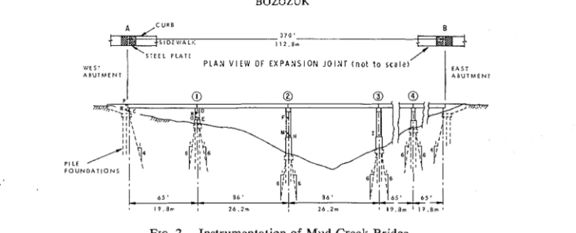
BOZOZUK A C U R B 370' S T E E L P L A T E V i E S T P L A N V l E l V OF E X P A N S I O N J O I N T ( n o t t o s c a l e ) A B U T M E N T P I L E F O U N D A T I O N S
FIG. 2. Instrumentation of Mud Creek Bridge.
TABLE 1. Change in verticality of bridge piers and abutments from 1959 t o 1973
Abutment Reference Range of angular movement
or pier pins Vertical spacing (top us. bottom pin)
West abutment P-R 5 ft (1.52 m) 0.76 mm west to I .02 mm east
Pier No. 1 N-0 5 ft (1.52 m) 7.44 mm west to 3 . 3 0 mm east
Pier No. 2 F-M 16 ft (4.88 m) 1.78 mm west t o 3 . 3 0 mm east
horizontal forces in the direction of traffic. The abutments are backfilled with 6 to 10 ft (1.8 to 3.1 m ) of earth fill which loads the subsoil to about 30% of its preconsolidation pressure.
T o measure the tilting of the piers and abut- ments, and the relative horizontal movements between them, permanent reference points were established at the locations shown in Fig. 2. Steel pins driven with a Ramset gun were in- stalled in pairs, one directly above the other
at thc vertical spacings given in Table 1 to
measure tilting. Measurements were made with a plumb bob connected to a washer with a fine steel wire and suspended from points P, N, and F to the respective points R , 0, and M. Vertical grooves cut into the lower pins estab- lished the original vertical reference line of the piers. Subsequent surveys indicated the change in verticality with time.
T o measure the relative horizontal move- ments between the abutments and piers, steel
pins were established at the points C, D, E,
F, H, and I (Fig. 2 ) . The eye of a 100 ft
(30.49-m) steel tape was bolted in turn to the
pins at D, F, and I. The chain was then
stretched horizontally, under an applied ten- sion of 30 Ib (13.6 kg), to the respective pins
C, E, and H respectively, and the distance
measured. Air temperatures were also mea- sured so that the taped distances could be corrected for temperature differences between surveys.
The relative horizontal movements between the abutments were measured by chaining over the bridge deck between steel finger plates A
and B on the abutments (Fig. 2 ) .
Field Observations
It was necessary to measure the inclination of the piers on calm days because the slightest breeze would set the plumb bob in motion and thus affect the observations.
The surveys showed that the west abutment and Piers 1 and 2 did not remain vertical after construction. The maximum range of horizon- tal movement of the top pins relative t o the lower ones for the period 1959 to 1973 is given in Table 1. The inclination of the west abutment varied from 0.76 mm west of ver- tical to 1.02 mm east, over a vertical distance of 5 ft (1.52 m ) . The angular rotation of Pier 2 was about the same, whereas that of Pier 1 was about five times as much as that of the abutment.
In addition to rocking about their bases, the abutments and piers converged horizontally. Measurements of horizontal distances between
24 CAN. GEOTECH. J . VOL. 13, 1976
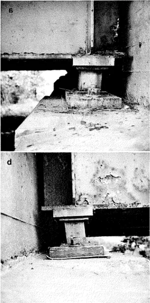
FIG. 3. Inclination of bridge bearings due t o hori- zontal movements of the abutments. ( a ) Tilted bearing at southwest corner of bridge. ( b ) Tilted bearing at northwest corner of bridge.
the established points from 1959 to 1973 showed that the west abutment and Pier 1 con- verged 0.70 cm, Piers 1 and 2 converged 1.77 cm, and Piers 2 and 3 converged 1.61 cm.
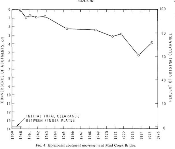
A photograph of one of the bridge bcarings (Fig. 3 ) taken in 1975 illustrates the magni- tude of the abutment movements. The total convergence of the two abutments was almost 4 cm, causing the bearings to tilt about 10" from the vertical. The decrease in horizontal distance between abutments from 1959 to
1975 is shown on Fig. 4. If this rate of con- vergence continued, the 13.77 cm of original clearance between finger plates would disap- pear in 40 to 50 years. The movements, how- ever, are not regular with time. Comparing this figure with the total annual precipitation record in Fig. 5 (obtained from the weather station at
the Ottawa International Airport, 8 mi (13
km) southwest of Mud Creek Bridge) showed that the larger movements occurred during periods of high precipitation. Prolonged per- iods of abnormally high precipitation could thcrefore accelerate the closure of the expan- sion joints. A wet period also precipitated the landslide that occurred in the west slope of the creek, north of the bridge, in the spring of 1973.
Discussion
The clay slopes were known to be moving at the site because the foundations of the original bridge wcre damaged by soil creep. This behaviour is not restricted to this loca-
tion. Mitchell and Eden ( 1972) instrumented
a number of natural slopes in marine clay in the Ottawa area with slope inclinometers and measured soil movements varying from 0.3 to 1 cm/year. They concluded that the magni- tude of soil creep is directly related to the climatic conditions; the wetter the year the greater the movcment. Landslide activity is similarly related to climatic conditions, with the greatest number occurring during wet ycars when the natural ground water table is at its highest elevation.
The horizontal movement rneasurcd on Mud Creck Bridge is of the same magnitude as the 'creep' measurements reported by Mitchell and Edcn (1972). As the bridgc bearings func- tioned normally in cold weather, the move- ments could not be attributed to this cause. Furthermore, the applied loads from the ap- proach embankments wcre insufficient to cause appreciable consolidation of the foundation soil, and the characteristic 'bump' often en- countered when an approach fill settles rela- tive to an abutment did not materialize at the site. Therefore, the settlement of the backfill and consolidation of the subsoil was also eliminated as a major cause. This left soil creep along the valley slopes as the principal cause of the foundation movements.
BOZOZUK 25 -9
-
\okol-o'
I I I I I I I I I I I I - \o 0 --
- -\P-
0 --
--
- - --
- I N I T l A L T O T A L C L E A R A N C E B E T W E E N F I N G E R P L A T E S I I I I I I I I I I I I I I I -FIG. 4. Horizontal abutment movements at Mud Creek Bridge.
FIG. 5. Total annual precipitation at Ottawa Inter-
national Airport, 8 mi (13 km) southwest of Mud
Creek Bridge.
large ~novements measured in 1973 were re-
covered. The questions then arise of what would the horizontal movements have been had battered piles not been provided, and how many battered piles would be required to anchor the piers and abutments in their or- iginal positions?
The change in inclination of the piers and abutments could be due to seasonal tempera- ture changes. As the bridge deck expanded or contracted, some of the forces were trans- mittted through the bearings, causing the piers and abutments to rock through a vertical arc about their bases.
The 29 battered piles installed to resist Conclusions
horizontal forces and movements in the direc- The principal cause of the horizontal foun-
tion of traffic obviously were not effective in dation movements is soil creep occurring along
maintaining the piers and abutments in their the valley slopes, which in turn is related to
original positions. They did appear to provide the total annual precipitation for the area. The
26 CAN. GEOTECH. J. VOL. 13, 1976
and abutments is probably due to the expan- sion and contraction of the bridge deck caused by seasonal temperature changes.
End bearing batter piles were not entirely effective in maintaining the piers and abut- ments in their original positions.
Acknowledgments
The Roads Department of the Regional Municipality of Ottawa-Carleton provided the opportunity for performing the observations, and the paper is published with their permis- sion. Thanks are due to the technical staff of the Geotechnical Section who carried out the surveys.
This paper is a contribution from the Divi- sion of Building Research, National Research Council of Canada, and is published with the approval of the Director of the Division.
DILLON, R. M. and EDWARDS, P. H. D. 1961. The Inspec-
tion, repair and maintenance of highway bridges in Lon- don, Ontario. Eng. Inst. Can. Eng. J. 44(1 l), pp. 3948.
MARCHE, R. and LACROIX, Y. 1972. StabilitC des cultes de
ponts Ctablies sur des pieux traversant une couche molle. Can. Geotech. J. 9(1), pp. 1-24.
MITCHELL, R. J. and E D E N , W . J . 1972. Measured move-
ments of clay slopes in the Ottawa area. Can. J. Earth
Sci. 9(8), pp. 1001-1013.
STERMAC, A . G., DEVATA, M., and SELBY, K. G. 1968.
Unusual movements of abutments supported on end- bearing piles. Can. Geotech. J. 5(2), pp. 69-79.