HAL Id: hal-00299072
https://hal.archives-ouvertes.fr/hal-00299072
Submitted on 1 Jan 2003
HAL is a multi-disciplinary open access
archive for the deposit and dissemination of
sci-entific research documents, whether they are
pub-lished or not. The documents may come from
teaching and research institutions in France or
abroad, or from public or private research centers.
L’archive ouverte pluridisciplinaire HAL, est
destinée au dépôt et à la diffusion de documents
scientifiques de niveau recherche, publiés ou non,
émanant des établissements d’enseignement et de
recherche français ou étrangers, des laboratoires
publics ou privés.
and implications for understanding its history of
movement
M. Parise
To cite this version:
M. Parise. Observation of surface features on an active landslide, and implications for understanding
its history of movement. Natural Hazards and Earth System Science, Copernicus Publications on
behalf of the European Geosciences Union, 2003, 3 (6), pp.569-580. �hal-00299072�
Mario Parise
CNR-IRPI, c/o Istituto di Geologia Applicata e Geotecnica, Politecnico di Bari, Via Orabona 4, 70125 Bari, Italy
Abstract. Surface features are produced as a result of
in-ternal deformation of active landslides, and are continuously created and destroyed by the movement. Observation of their presence and distribution, and surveying of their evolution may provide insights for the zonation of the mass movement in sectors characterized by different behaviour. The present study analyses and describes some example of surface fea-tures observed on an active mass movement, the Slumgul-lion earthflow, in the San Juan Mountains of southwestern Colorado. The Slumgullion earthflow is one of the most fa-mous and spectacular landslides in the world; it consists of a younger, active part which moves on and over an older, much larger, inactive part. Total length of the earthflow is 6.8 km, with an estimated volume of 170 × 106m3. Its nearly
con-stant rate of movement (ranging from about 2 m per year at the head, to a maximum of 6–7 m per year at its narrow and central part, to values between 1.3 and 2 m per year at the active toe), and the geological properties of moving material, are well suited for the observation of the development and evolution of surface features.
In the last 11 years, repeated surveying at the Slumgul-lion site has been performed through recognition of surface features, measurements of their main characteristics, and de-tailed mapping. In this study, two sectors of the Slumgullion earthflow are analysed through comparison of the features observed in this time span, and evaluation of the changes oc-curred: they are the active toe and an area located at the left flank of the landslide. Choice of the sectors was dictated in the first case, by particular activity of movement and the nearby presence of elements at risk (highway located only 250 m downhill from the toe); and in the second case, by the presence of many surface features, mostly consisting of sev-eral generations of flank ridges.
The active toe of the landslide is characterized by contin-uous movement which determines frequent variations in the presence and distribution of surface features, as evidenced by the multi-year observations there performed. In
addi-Correspondence to: M. Parise ([email protected])
tion, monitoring of the inactive material just ahead of the ac-tive toe showed that this sector is experiencing deformation caused by the advancing toe. Mapping and interpretation of the different generations of flank ridges at the narrowest and central part of the active Slumgullion landslide evidenced, on the other hand, the gradual narrowing of the mass movement, which was accompanied by a reduction in the thickness of the material involved in landsliding.
Multi-time observation of the surface features at the Slumgullion earthflow allowed to reconstruct the evolution of specific sectors of the mass movement. This low-cost ap-proach, whose only requirements are the availability of a de-tailed topographic map, and repeated surveying, is therefore particularly useful to better understand the kinematics of ac-tive mass movements, also in order to design the more ap-propriate stabilization works.
1 Introduction
Identification of elements that characterize different parts of a landslide is an important aspect in the geomorphological analysis of mass movements. Features at the surface of ac-tive landslides are generally short-lived and can be quickly destroyed. However, depending on factors such as the type of landslide, the rate of movement, and the rheology of materi-als involved, in some cases they can persist, and their vation (especially when performed through periodic obser-vations, in order to monitor their temporal evolution) might result in useful information for understanding the kinemat-ics of the landslide and evaluating the related hazard (Ter-Stepanian, 1967; Zaruba and Mencl, 1982; Varnes, 1984), as well as for recognition of different phases in its history of movement. In addition, observations at the surface have also provided useful insights for reconstruction of the geom-etry of slip surfaces (Hutchinson, 1983; Carter and Bentley, 1985; Cruden, 1986).
In this paper, the importance of the recognition and map-ping of surface features on active landslides will be
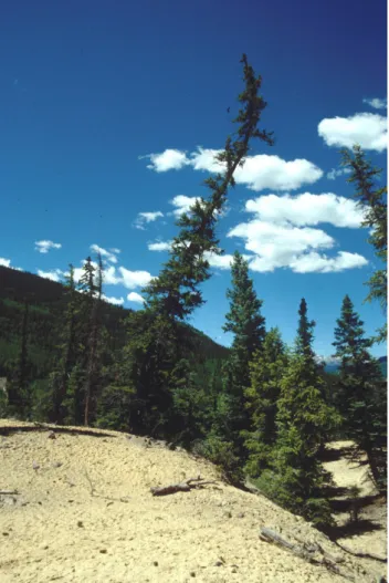
out-Fig. 1. Example of tilted tree, showing vertical growing after that
displacement at the site caused the curvature in the trunk.
lined by describing multi-time surveying performed over a 11 year time span at the Slumgullion landslide, one of the best-known mass movements in the world.
2 Surface features of active landslides
Active landslides (sensu WP/WLI, 1993) are generally char-acterized by deformational features that are the result of dif-ferential movement within the mobile mass and between this mass and the underlying material. The nature of the features, as well as their positions and orientations, are indicative of different kinds of deformation. Their large-scale mapping, together with information derived from indirect indicators, may help in understanding the behavior of different parts of the landslide, and can eventually allow a zonation into land-slide elements.
Many different types of features can be observed at the sur-face of active landslides, including scarps; fractures; basins; areas of temporary or permanent water ponding; ridges, etc. Each of these features is related to the style of deforma-tion acting at that moment, or which has been active in past times, in that particular part of the landslide. Many of them
are ephemeral, since weathering, erosion and ongoing defor-mation tend to erase prior traces of movements (Wieczorek, 1984).
It is possible to discriminate between direct and indirect indicators of deformation (Fleming et al., 1999): the first are those structures directly connected to structural discon-tinuities affecting the landslide material (IAEG Commission on Landslides, 1990), while the latter lack this direct asso-ciation. Nevertheless, indirect indicators may provide infor-mation about the type and style of local deforinfor-mation. In-direct indicators include, for example, changes in the hy-drography at the surface of the landslide and changes to the vegetation cover. Active landslides, and sometimes even dormant ones, typically have very high moisture contents. Ephemeral and perennial streams occur or are located, re-spectively, within the landslide and along its flanks. Changes in location and discharge of springs, and diversions in the pattern of the drainage network can be used to derive infor-mation about changes in the type and style of deforinfor-mation (Williams, 1988).
Further information can be obtained through the observa-tion of trees and vegetaobserva-tion, since these are often affected by phases of movement and may register different episodes of displacement. The distribution of vegetation cover on the landslide, and the degree of vegetation disturbance, can be used to indicate the amounts of movement occurring across the landslide and even the relative ages of these movements. Continuously active areas are generally characterized by bare ground, or at least by the presence of relatively few trees, whilst in areas of recent movement the trees show clear signs of disturbance. Often trees are tilted during the movement, and then grow vertically during the period of inactivity, leav-ing a characteristic “stem bend” (Fig. 1). The relative age of the movement can then be inferred by these curvatures in the tree trunks.
In several areas, the observation of trees may also allow the determination of the width of tension cracks and the amount of lateral movement along shear surfaces. This is the case for trees split into two or more parts because they straddle active cracks (Fig. 2). The direction of differential move-ment required to produce the split can be used, together with stretching or buckling of tree roots, as an indicator of local deformation (Fleming et al., 1999). Often the trees are still alive in spite of the breaking.
The present study, by illustrating large-scale geomorpho-logical mapping of surface features on an active landslide, and their interpretation through multi-time observations, is intended to stress the use of these information for a better understanding of the landslide kinematics, and the possibility to perform a zonation into landslide elements that are charac-terized by different styles of deformation. The methodology here illustrated for the Slumgullion landslide may be easily exported to other slow-moving mass movements, where large scale topographic maps are available.
(a) (b)
Fig. 2. Trees split in, respectively, four and two parts because they straddle active cracks: (a) spruce fir; (b) aspen tree. Both the trees were
still alive at the time the pictures were taken.
3 General setting of the Slumgullion landslide
The site of this study is the world famous Slumgullion land-slide1, a large mass movement in the San Juan Mountains of Colorado (Fig. 3). It consists of a younger, active movement (3.9 km long) with an estimated volume of about 20×106m3 (Parise and Guzzi, 1992), which moves on and over an older, much larger (6.8 km long), inactive landslide (Fig. 4). Over-all, the volume of the complete landslide system is estimated at about 170 × 106m3(Parise and Guzzi, 1992).
1Observations dealing with the kinematics of the movement at
Slumgullion site have shown that most of the movement of the ac-tive part of the Slumgullion earthflow takes place along the shear surfaces that also define the flanks of the landslide (Crandell and Varnes, 1960, 1961; Guzzi and Parise, 1992; Baum and Fleming, 1996; Fleming et al., 1999). Therefore, it is more correct to refer to it as an earth slide or landslide (IAEG Commission on Land-slides, 1990; Cruden and Varnes, 1996). However, since it has been described for a long time as earthflow (and sometimes also used as typical example for this category of slope movement), the term earthflow has become and still remains traditionally popular for the Slumgullion. In this paper, I use interchangeably the terms earth-flow and landslide in referring to the slope movement.
The Slumgullion landslide formed as a result of the col-lapse of hydrothermally altered volcanic materials in the rim of the Lake City caldera (Lipman, 1976), on the south end of the Mesa Seco plateau. The landslide deposit flowed downhill, deviating the original course of the Slumgullion Creek, and eventually damming the Lake Fork of the Gunni-son River, creating Lake San Cristobal (Schuster, 1985). The materials exposed in the scarp are hydrothermally altered and unaltered volcanic rocks including tuffs and intrusive and ex-trusive rocks of variable compositions (Diehl and Schuster, 1996). The hydrothermal brecciation and alteration, com-bined with the weakening of the rock mass by intersections of numerous faults, was apparently a prime factor in the ori-gin of the Slumgullion landslide. In fact, most of the material observed on the landslide consists of silts and clays with low strength, medium to high plasticity and high swelling poten-tial (Chleborad et al., 1996). Locally, large assemblages of boulders are present.
This occurs in particular at the base of the main scarp, which is mantled with continuous belt of detrital material consisting of talus cones and rock-fall deposits (Fig. 5). The talus cones are built by successive and discontinuous accu-mulations of debris falling from the near-vertical to
over-Fig. 3. View of the Slumgullion landslide, taken uphill from the
State Highway 149.
Fig. 4. Location map showing the boundaries of both inactive and
active parts of the Slumgullion earthflow. The two sectors described in the paper are shown as insets: (1) the active toe; (2) the narrowest part of the active landslide.
hanging rock walls above. Rock-fall deposits, on the other hand, form large accumulations of clast-supported angular blocks and coarse boulders, which typically show an irregu-lar hummocky morphology (Parise and Moscariello, 1997).
The Slumgullion earthflow has attracted the attention of investigators since the 19th century when Endlich (1876) de-scribed it in a short note in the report of the Hayden Survey of 1874. It has since been cited by numerous other investigators (Cross, 1909; Howe, 1909; Atwood and Mather, 1932; Bur-bank, 1947, for example). The earliest photographs of the landslide were published at the beginning of the 20th century by Whitman Cross (plate XXB in Howe, 1909). However, even though it has been known about for a long time, and in-deed it has become one of the most famous mass movements in North America, the only specific study of the Slumgul-lion landslide was undertaken by Crandell and Varnes, who in 1958 measured the movement of the landslide (Crandell
Fig. 5. Talus deposits at the base of the Slumgullion main scarp.
and Varnes, 1960, 1961). Observations of changes in the sur-vey lines crossing the slide, and of advances of the active toe, were made several times between 1958 and 1973. Even-tually, in 1990 the United States Geological Survey (USGS), in cooperation with the National Research Council of Italy (CNR), initiated a program devoted to studying and monitor-ing the landslide.
Some characteristics of the Slumgullion landslide are par-ticularly favourable for the observation and analysis of sur-face features; they essentially are: (1) the overall slow ve-locity; (2) the nearly constant rate of movement; (3) the ge-ological properties of moving material; (4) the low levels of anthropogenic modification.
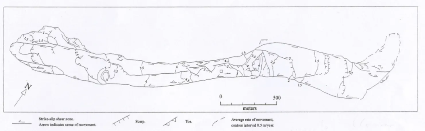
Monitoring of the landslide, which has been discontinu-ously performed since 1958, has showed that the velocity ranges from about 2 m per year at the head, to a maximum of 6–7 m per year at its narrow-central part, to values between 1.3 and 2 m per year at the active toe (Fig. 6).
Since 1998, GPS (Global Positioning System) observa-tions have been performed on the active portion of the Slumgullion landslide, and the seasonal movement has been interpreted in the context of selected hydrologic and mete-orologic data (Coe et al., 2000, 2003). The main output of this study is that the landslide moves throughout the year, but daily velocities are highly variable on a seasonal basis. Seasonal variability in velocities is probably due to changes in ground-water levels, which decrease when surface water is unavailable or cannot infiltrate frozen ground and increase when surface water from melting snow or rainfall infiltrates unfrozen ground. This hypothesis is supported by data show-ing seasonal changes in soil-water content and by a corre-spondence between the velocity and air- and soil-temperature data from a meteorological station on the slide (Coe et al., 2003). In general, the velocity of the slide increases or de-creases with rising or falling temperatures. Annual move-ments and daily velocities are lowest at the head and toe of the landslide and highest in the central, narrowest part of the landslide. Movements and velocities deviated from this dis-tribution in areas where they were affected by major
struc-Fig. 6. Sketch of the Slumgullion landslide, showing average velocities as obtained from field measurements and photogrammetric analyses
(data from Smith, 1993, and from Fleming et al., 1999). The square at the narrowest part of the landslide indicates the approximate site of maximum velocity, reaching about 7 m/year.
tural elements within the slide (Gomberg et al., 1995; Baum and Fleming, 1996).
4 Observation of surface features at the Slumgullion landslide
In the active part of the Slumgullion landslide, two sectors have been chosen for detailed analysis of the surface features, and for evaluation of their evolution: they are the active toe, and the flanks of the landslide at its narrowest part (Fig. 4). Choice of the sectors was dictated in the first case by particu-lar activity of movement and the nearby presence of elements at risk; in the second case, by the presence of the most promi-nent surface features of the landslide, the flank ridges. 4.1 The active toe
The first sector described is the distal portion of the active landslide, and in particular the active toe (Fig. 4). This is an area of particular interest, due to the nearby presence of a communication route: State Highway 149 runs only 250 m downhill from the active toe and is at risk from a continua-tion of the current landslide movement pattern. To determine if loading exerted by the currently moving material causes deformation of the inactive deposits, a team led by David J. Varnes (USGS) began surveying this part of the landslide in 1991. The surveys undertaken to date indicate that the in-active part of the Slumgullion earthflow is responding to the load caused by the advancing toe, and is not as stable as pre-viously assumed (Varnes et al., 1996).
In this area, based on the results of seismic reflection and refraction profiles, Williams and Pratt (1996) estimated a maximum landslide thickness of about 95 along a profile below the active toe and to the east of State Highway 149 (Fig. 4). At the same site, on the other hand, Parise and Guzzi (1992) suggested, based upon geomorphic considerations, a thickness of about 120 m.
Fig. 7. Active toe of the Slumgullion earthflow, about 250 m
up-slope from the area where State Highway 149 crosses the inactive landslide deposit.
In plan view the active toe is rounded, whilst in profile it has a steep frontal slope, from 30 to 40 m high, with an av-erage slope angle of 18◦. The overall difference in elevation between the active and inactive deposits is accommodated through a series of scarps, whose height ranges from 0.5 to 8 m. Behind the toe, the slope angle decreases to an average value of 8◦.
The active toe is moving along the surface of the old land-slide deposits in bulldozer fashion, toppling and overriding trees as it goes (Fig. 7). It has an irregular trace along its northern half, which is probably a result of a velocity dis-continuity (higher displacement rates have actually been ob-served at its southern half).
The principal feature of the active toe is a series of scarps, ranging in height from 0.5 to 8 m. Most of them are the main scarps for minor landslides, primarily slumps. Pressure ridges are present on the northern and northwestern sides of the toe, with several steps whose height ranges from 0.3 to 1.2 m.
Fig. 8. Map of surface features at the active toe of the Slumgullion
landslide, as mapped in June–August 1991 (simplified after Guzzi and Parise, 1992).
Since the first surveys carried out at the Slumgullion site, it appeared that the active toe was one of the most rapidly evolving places in the landslide. Superimposition of minor mass movements, and the push exerted by the material ad-vancing from behind, produce significant deformations and changes in the morphology of this sector. Development and evolution of surface features produced by landslide move-ment at the active toe can be appreciated by comparing the maps by Guzzi and Parise in 1991 (Fig. 8) and by Fleming and others in 1993 (Fig. 9): both maps were produced by us-ing as topographic base a 1:10 000 scale map derived from the 1990 aerial photographs. Some features deserve to be here described briefly: in the 1991 surveying and mapping, pressure ridges were mapped at the northern and northwest-ern margins of the toe. Produced by deformation of stable ground in front of the active toe, they showed several steps with height ranging from 0.3 to 1.2 m. The 1993 map (Fig. 9) also shows the presence of pressure ridges, even though most of these structures had already been partially destroyed by the bulldozing effect of advancing material. More recent sur-veys (up to the most recent one in August 2001) showed that no pressure ridges are now visible in that area, since they have been completely overridden by the movement.
The most important aspect deriving from the comparison of the 1991 and 1993 maps is probably the better develop-ment at the ground of the shear surface that separates the toe into two sectors characterized by different velocities and styles of deformation: a few hundred meters uphill from the active toe, there is an increase in the width of the active
land-Fig. 9. Map of surface features at the active toe of the Slumgullion
landslide, as mapped in 1992-93 (simplified after Fleming et al., 1999).
slide, which is a result of spreading along the north flank. This zone of spreading contrasts with a zone of shortening on the south side, and the two zones are separated by a ma-jor shear surface. This shear surface is recognizable in the 1991 map from the area north of the larger of the two ponds (Fig. 8); moving downhill, after about 200 m, there is no clear evidence of the shearing at the ground surface, but a series of scarps and cracks can be identified, even though there is no clear throughgoing surface. In the 1993 map (Fig. 9) the scarps are much more continuous and connected, testifying the development at the surface of the structural discontinu-ity. The zone of spreading, located north of the shear sur-face, presents a lower velocity, in the range 0.3–1.4 m/year; on the other hand, the southern sector of the toe, where most of the movement appears to be now concentrated, shows a velocity between 1.3 and 2.5 m/year. The higher deforma-tion and displacement of this sector is also shown by internal toes, located 100–150 m from the boundary of the active toe, at the downslope margin of the ponds that were identified in 1991. Therefore, the major shear surface which separates the two sectors of the toe appears much more pronunciated in 1993 than in 1991; the more recent surveys have furthermore confirmed its longest morphological expression at the ground surface. The multi-time surveying showed in this case how an important feature became more visible at the surface of the landslide with time; the difference in velocities north and south of this shear surface again confirms the prominent role it is playing in the landslide evolution. However, it is worth noting that its presence had already been recognized and mapped during the first surveys in 1990.
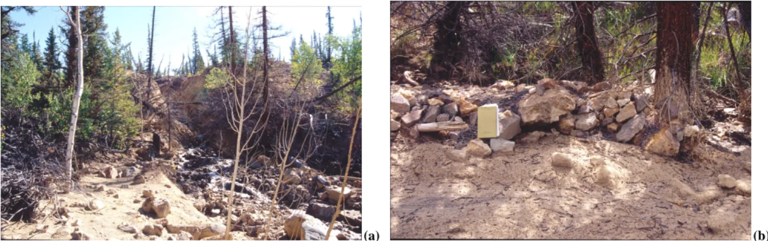
In the last few years, further changes have occurred at the active toe, in the form of debris flows that affected its central
Fig. 10. Path (a) and deposits (b) from debris flows occurring at the active toe.
part. Starting from the steep sectors at the upper part of the toe, the debris material moved following one of the main wa-ter lines (Fig. 10a), and invaded the area just downhill from the active toe. The sector affected by these processes is lo-cated about along the direction of the major shear surface described above. Debris flows occurred in 1999 and 2000, even though the exact dates of occurrence are not available (W.Z. Savage, personal communication). Debris-flow de-posits consist of sub-rounded to sub-angular boulders, cob-bles and pebcob-bles in a fine matrix. A train of boulders and splash marks on tree trunks up to a height of 50 cm have been observed (Fig. 10b). Several small flank ridges, 0.4 m high, are also present, showing sub-angular clasts aligned at their top. Spreading of the debris material was so extensive that some of the control points of Varnes’ network were de-stroyed by the debris or covered to a thickness of some 10 to 20 cm.
Observations of the displacement vector of the active toe relative to nonmoving ground indicate continuing thickening of the toe (Fleming et al., 1999); therefore, displacement of the landslide tends to steepen the front of the active toe. This could still increase deformations in the area ahead of the ac-tive toe, as well as favouring minor mass movements at the steep and unstable active front.
4.2 The flank ridges at the narrowest part of the landslide The second study area is located at the narrowest part of the landslide (Fig. 4). Narrowing of the landslide is ac-commodated in an area where the width decreases from the about 300 m to 230 m and then to 150 m, where Crandell and Varnes (1960, 1961) measured the maximum displacement rate and established a survey line (Fig. 6). The narrowing is also accompanied by an abrupt change in slope. This sector is characterized by flank ridges that are commonly the best preserved feature of active landslides, especially of the flow type. They have been studied by many authors (e.g. Rick-mers, 1913; Sharp, 1942; Johnson, 1970), described with many different names (including levees, rims, lateral ridges, etc.), and interpreted in different ways. Keefer and
John-son (1983) distinguished three different ways ridges can form at the flanks of an earthflow; Zaruba and Mencl (1982) and Fleming et al. (1988) used the height of the flank ridges to estimate the displacement of landslides. Fleming and John-son (1989) distinguished ridges formed by deposition from those formed by deformation of landslide debris; they also surveyed the growth of flank ridges and the development of structures associated with them. Corominas (1995) has more recently reviewed many of the proposed mechanisms for for-mation of flank ridges; he made a strong case for basal ero-sion and shear in the development of flank ridges.
On the active part of the Slumgullion landslide, several generations of ridges are present, both on the flanks of the landslide and within it (Fig. 11). Some of them are actively growing, as indicated by the freshness of the exposed debris and the development of small lateral landslides.
In plan view, the flank ridges are elongate, convex down-ward at their termini, and generally symmetric. The axes of the flank ridges mostly follow the curvature of the boundaries of the landslide. Their course can be continuous for long dis-tances, up to hundreds of meters, or it can be discontinuous so that the ridge is formed by several segments. Width is always very small with respect to length. The height of the ridges ranges from tens of centimeters to 30 m.
The flank ridges are generally bounded by a more or less continuous shear surface, which is recognizable at the ground, or whose presence can be inferred by the en echelon cracks, which generally represent the precursory feature of a shear surface proceeding toward the ground (Pollard et al., 1982; Deng et al., 1986). Even though related to the gravity-driven movement of the landslide, these shear surfaces have also been described as strike-slip faults (Baum and Fleming, 1991; Baum et al., 1993; Gomberg et al., 1995), due to their analogy with these structural discontinuities (Segall and Pol-lard, 1980; Sylvester, 1988).
The flank ridges are commonly characterized by the con-centration of the coarser and rocky material in their upper part, forming the typical armoring that probably indicates upward transport (Fig. 12). Where very narrow ridges are
(a) (b)
Fig. 11. Flank ridges: (a) at the left boundary of the Slumgullion landslide; note the difference in height between the presently forming flank
ridge and the older one. (b) within the landslide body.
formed, the coarser material is also present on the side of the ridges. The boulders are often arranged with their longest axis perpendicular to the direction of the ridge. On the basis of observations of the main flank ridges at the Slumgullion landslide, it has been hypothesized that these boulders can be interpreted as the remnants of a wider cover made up by large blocks that was reworked and dismembered by the building up of the flank ridges (Parise et al., 1997). They should thus derive from boulder fields related to ancient rock-fall events. Within the body of the landslide, active ridges also form near minor shear surfaces. They have in general the same characteristics as those along the flanks but are com-monly smaller. Moreover, they appear to be more disturbed because of other differential movements within the landslide. As a result, there are scarps and tension cracks subparallel to the axis of these ridges combined with other features that ap-parently are not directly connected to their development and growth.
In transverse profile, the flank ridges show a convex-upward curve and V-shaped troughs on either side; the shape is then generally rounded if height and width are compara-ble. With increasing height, narrow ridges with steep slopes on both sides form. The ridges closer to the boundaries
of the landslide are generally parallel to each other, and in turn to the shear surface. In some cases the orientations are slightly convergent, reflecting local variations in the direc-tion of movement, and/or the development of minor shear surfaces not parallel to the main one.
There is a large contrast between the size of the older ridges and of those that are currently active (Fig. 11a): the inactive ridges are much larger, up to 30 m high. Those on the extreme outside of the landslide are the largest and, based on the size of trees and development of soil, appear to be the oldest.
Flank ridges that have formed along the flanks of a land-slide provide a basis to evaluate the history of movement in much the same way as moraines are useful indicators of movement history of a glacier. Observation of the main geo-morphic, pedologic, and sedimentologic features (Table 1) of the several generations of flank ridges at the Slumgul-lion landslide helped in reconstructing the chronology of their formation and to relate them to the so far reconstructed landslide history of movement (Madole, 1996; Parise et al., 1997; Fleming et al., 1999). This was obtained by surveying the variability of their features, including size of the ridges, the reciprocal relationships, continuity, main direction of the
brownish yellow [10YR 6/8]
Fig. 12. Armoring at the top of the main flank ridge bounding the
upper part of the active Slumgullion earthflow.
axes, presence and type of vegetative cover and of soils. Fig-ure 13 is a sketch of the narrowest part of the active land-slide, where a tentative chronology of the formation of flank ridges has been identified: the reconstruction of relative ages for ridges is numbered from 1 to 4, with 1 being the oldest (Figs. 13 and 14). Number 1 refers to a phase probably re-lated to movement of material from a secondary source area: it diverges from most of the other ridges, and is cut by flank ridge 2, whose main axis follows the direction of the active landslide. Flank ridge 3 is the closest to the present boundary of the active landslide; it shows good continuity and a fresher appearance than the two previous sets. Locally, there is a fur-ther set (number 4), with smaller values of its morphometric parameters.
Sets 2 and 3 of flank ridges were used, because of their continuity along most of the landslide, to estimate previous width and thickness of the landslide at the time of formation of the flank ridges: in fact, location and distribution of the different sets of flank ridges indicate past boundaries of the landslide, and there is a direct relationship between thick-ness of the material involved in the movement and size of the
bounding flank ridge. This analysis showed that the decreas-ing width of the landslide occurred with a reduction in the thickness of material involved in the movement (Parise et al., 1997). Thus, after formation of the largest flank ridges that mark the outer boundaries of Slumgullion, other successive phases of movement, or perhaps continual movement of a gradually decreasing volume of material, led to the building of new ridges within the older and larger ridges.
Thinning and narrowing of the Slumgullion landslide is due to decreasing sediment supply from the source area, and might progress until the lower reaches of the landslide could no longer move. Similar thinning and narrowing, again docu-mented by recent mapping (Fleming et al., 1999), will even-tually result in inactivity of the presently active part of the landslide unless there is an increase of material available in the source area.
5 Discussion and conclusions
For all except the most simple forms of mass movement, displacement produces internal deformation in the landslide mass. Each part of a landslide is generally characterized by different types and orientations of structures. The rate and type of movement, material properties, and boundary condi-tions as well as initial and changing stresses interact to pro-duce complex structures at the landslide ground surface. Ar-eas with simple structures that are related to only a single type of deformation are rare on a large, complex mass move-ment such as Slumgullion.
Nearly constant movement makes this landslide an excel-lent, large-scale natural laboratory. Mapping and interpreta-tion of the features produced by the movement along the ac-tive margins and within the body of its acac-tive part show that the Slumgullion landslide can be partitioned into separate re-gions based on the style of deformation. The main scarp and the head of the slide exhibit a prevailing extensional style of deformation, expressed under the forms of scarps perpendic-ular to the main direction of movement. Deformation in the narrow, central part of the landslide is characterized by the
Fig. 13. Sketch of the narrowest part of the Slumgullion landslide, showing the several generations of flank ridges and their relative
chronol-ogy (from the oldest 1 to the youngest 4). Traces of the transverse profiles of Fig. 14 are shown.
Fig. 14. Transverse profiles (looking downslope) at the narrowest part of the Slumgullion landslide. Location of profiles is shown in Fig. 13.
main shear surfaces bounding the active landslide, and their related features. The toe of the slide, eventually, is a region of compressive deformation, particularly well shown downhill from the main pond.
The pattern of the overall movement at the landslide sur-face is consistent with the above zonation; it shows in fact that the highest surface-flow velocity, averaging 6–7 m/yr, occurs halfway down the active portion where the earthflow is confined to a width of 150 m. Flow velocities in the up-per, wider part of the flow are estimated to be 2 m/yr. Flow velocities in the active toe are in the range 1.3–2.5 m/yr.
The most recent phase of monitoring carried out at the ac-tive part of the Slumgullion landslide (a 3.5-year monitoring period, from July 1998 to March 2002) has shown that the landslide moved throughout the period but velocity varied on a seasonal basis (Coe et al., 2003). Seasonal variability in velocities is due to groundwater levels and corresponding pore pressures that increase when surface water from melting snow or rainfall infiltrates the landslide material. Therefore, seasonal variability in velocities appear to be primarily con-trolled by the availability of surface water (Coe et al., 2003). As regards the present study, it has to be stressed the fact
structural elements, and their influence on variability of the landslide movement, may lead to incorrect interpretations of the spatial and/or seasonal variations in the landslide move-ment. This, in turn, could result in inaccurate evaluation of the landslide pattern, and cause wrong decisions when de-signing the more appropriate and stabilization works.
Even though with some limitations such as those outlined by Giardino (1996), that include topographic problems, re-liability of the mapping due to state of activity of different features, and rheology of different materials, the multi-time surveying of surface features is therefore a low-cost approach that may produce the acquisition of a great amount of data about the evolution of a landslide, eventually resulting in in-formation aimed at a better definition of the more appropriate intervention works.
This study, by describing some examples from the active part of the Slumgullion landslide, intended to stress the im-portance of large-scale geomorphological mapping, and es-pecially of its repetitivity in time, for the study of active mass movements. In particular, the combination of: (1) detailed mapping of surface features; (2) information derived from indirect indicators of deformation; (3) measurement of dis-placement; (4) multi-time surveying; may result extremely useful for a better understanding of the landslide and its zona-tion in different elements characterized by different style of deformation.
Acknowledgements. I am grateful to many people that helped me
during the work at Slumgullion: first and foremost, Robert Flem-ing and David Varnes were always open to discussion and provided me with precious advices and suggestions. Other people worked at different times with me at the landslide: Raffaela Guzzi, William Savage, Rex Baum, Marino Sorriso Valvo, Robert Schuster, Jeff Coe, Andrea Moscariello. To all of them, I express my most sincere gratitude.
This work is dedicated to the memory of Raffaela Guzzi, with whom I started in 1990 to map and study the surface features at the Slumgullion landslide.
References
Atwood, W. W. and Mather, K. F.: Physiography and Quaternary geology of the San Juan Mountains, Colorado. U.S. Geological Survey Professional Paper 166, 176 p., 1932.
neath landslides: prediction from surface measurements, Can. Geotech. J., 22, 234–238, 1985.
Chleborad, A. F., Diehl, S. F., and Cannon, S. H.: Geotechnical properties of selected materials from the Slumgullion landslide, in: The Slumgullion earthflow: a large-scale natural laboratory, edited by Varnes, D. J. and Savage, W. Z., U.S. Geological Sur-vey Bulletin 2130, 67–72, 1996.
Coe, J. A., Godt, J. W., Ellis, W. L., Savage, W. Z., Savage, J. E., Powers, P. S., Varnes, D. J., and Tachker, P.: Preliminary inter-pretation of seasonal movement of the Slumgullion landslide as determined from GPS observations, July 1998 – July 1999, U.S. Geological Survey Open-File Report 00-102, 25 p., 2000. Coe, J. A., Ellis, W. L., Godt, J. W., Savage, W. Z., Savage, J. E.,
Michael, J. A., Kibler, K. D., Powers, P. S., Lidke, D. J., and Debray, S.: Seasonal movement of the Slumgullion landslide de-termined from Global Positioning System surveys and field in-strumentation, July 1998 – March 2002, Engineering Geology, 68, 67–101, 2003.
Corominas, J.: Evidence of basal erosion and shearing as mecha-nism contributing to the development of lateral ridges in mud-slides, flow-mud-slides, and other flow-like gravitational movements, Engineering Geology, 39, 45–70, 1995.
Crandell, D. R. and Varnes, D. J.: Slumgullion earthflow and earth-slide near Lake City, Colorado [abs.], Geological Society of America Bulletin, 71 (12), pt. 2, p. 1846, 1960.
Crandell, D. R. and Varnes, D. J.: Movement of the Slumgullion earthflow near Lake City, Colorado, in: Short Papers in the Ge-ologic and HydrGe-ologic Sciences, U.S. GeGe-ological Survey Profes-sional Paper 424-B, B136–B139, 1961.
Cross, W.: The Slumgullion mud flow, Science, 30 (760), 126–127, 1909.
Cruden, D. M.: The geometry of slip surfaces beneath land-slides: prediction from surface measurements. Discussion, Can. Geotech. J., 23, 94, 1986.
Cruden, D. M. and Varnes, D. J.: Landslide types and processes, in: Landslides. Investigation and mitigation, edited by Turner, A. K. and Schuster, R. L., Transp. Res. Board, Nat. Res. Council, Spec. Rep. 247, Washington, D.C., 36–75, 1996.
Deng, Q., Wu, D., Zhang, P., and Chen, S.: Structure and defor-mational character of strike-slip fault zones, Pure and Applied Geophysics, 124 (1-2), 203–223, 1986.
Diehl, S. F. and Schuster, R. L.: Preliminary geologic map and alter-ation mineralogy of the main scarp of the Slumgullion landslide, in: The Slumgullion earthflow: a large-scale natural laboratory, edited by Varnes, D. J. and Savage, W. Z., U.S. Geological Sur-vey Bulletin 2130, 13–19, 1996.
Geographical Survey (Hayden) of the Territories Annual Report 1874, 203 p., 1876.
Fleming, R. W. and Johnson, A. M.: Structures associated with strike-slip faults that bound landslide elements, Engineering Ge-ology, 27, 39–114, 1989.
Fleming, R. W., Johnson, R. B., and Schuster, R. L.: The reactiva-tion of the Manti landslide, in The Manti, Utah, landslide, U.S. Geol. Survey Professional Paper 1311, 1–22, 1988.
Fleming, R. W., Baum, R. L., and Giardino, M.: Map and descrip-tion of the active part of the Slumgullion landslide, Hinsdale County, Colorado, U.S. Geological Survey Geologic Investiga-tion Series I-2672, scale 1:1,000, 34 p., 1999.
Giardino, M.: Validit`a e limiti del rilevamento geomorfologico di deformazioni superficiali per l’analisi cinematica di fenomeni franosi: il caso della frana di Slumgullion, Colorado (USA), Proc. Int. Conf. “Prevention of Hydrogeological Hazards: The Role of Scientific Research”, Alba (Italy), 1, 285–294, 1996. Gomberg, J. S., Bodin, P. W., Savage, W. Z., and Jackson, M. E.:
Landslide faults and tectonic faults, analogs? The Slumgullion earthflow, Colorado, Geology, 23 (1), 41–44, 1995.
Guzzi, R. and Parise, M.: Surface features and kinematics of the Slumgullion landslide near Lake City, Colorado, U.S. Geological Survey Open-File Report 92-252, 45 p., 1992.
Howe, E.: Landslides in the San Juan Mountains, Colorado, U.S. Geological Survey Professional Paper 67, 45 p., 1909.
Hutchinson, J. N.: Methods of locating slip surfaces in landslides, Bull. Ass. Eng. Geologists, 20 (3), 235–252, 1983.
IAEG Commission on Landslides: Suggested nomenclature for landslides, Bull. Int. Ass. Eng. Geology, 41, 13–16, 1990. Johnson, A. M.: Physical processes in geology, Freeman, Cooper
and Co., San Francisco, California, 577 p., 1970.
Keefer, D. K. and Johnson, A. M.: Earth flows: morphology, mo-bilization, and movement, U.S. Geological Survey Professional Paper 1264, 56 p., 1983.
Lipman, P. W.: Geologic map of the Lake City caldera area, west-ern San Juan Mountains, south-westwest-ern Colorado, U.S. Geologi-cal Survey Miscellaneous Investigations Series Map I-962, sGeologi-cale 1:48 000, 1976.
Madole, R. F.: Preliminary chronology of the Slumgullion land-slide, Hinsdale County, Colorado, in: The Slumgullion earth-flow: a large-scale natural laboratory, edited by Varnes, D. J. and Savage, W. Z., U.S. Geological Survey Bulletin 2130, 5–7, 1996. Munsell, Munsell soil color charts, Munsell Color Company Inc.,
Baltimore, Maryland, USA, 1954.
Parise, M. and Guzzi, R.: Volume and shape of the active and in-active parts of the Slumgullion landslide, Hinsdale County, Col-orado, U.S. Geological Survey Open-File Report 92-216, 29 p., 1992.
Parise, M. and Moscariello, A.: Geologic hazards and relative slope stability of the inactive part of the Slumgullion landslide, south-western Colorado, U.S. Geological Survey Open-File Report 97-706, 16 p., 1997.
Parise, M., Moscariello, A., and Fleming, R. W.: Evidence from flank ridges for long-term diminishing movements of the Slumgullion landslide, Hinsdale County, Colorado, U.S. Geolog-ical Survey Open-File Report 97-517, 14 p., 1997.
Parise, M., Coe, J. A., Savage, W. Z., and Varnes, D. J.: The Slumgullion landslide (southwestern Colorado, USA): investi-gation and monitoring, Proc. Int. Workshop “Flows 2003”, Sor-rento (Italy), 14–16 May, 2003.
Pollard, D. D., Segall, P., and Delaney, P. T.: Formation and inter-pretation of dilatant echelon cracks, Geol. Soc. Am. Bull., 93, 1291–1303, 1982.
Rickmers, W. R.: The Duab of Turkestan – a physiographic sketch and account of some travels, Cambridge Univ. Press, London, 197 p., 1913.
Schuster, R. L.: Landslide dams in the Western United States, Proc. IVth Int. Conf. and Field Workshop on Landslides, Tokyo, 411– 418, 1985.
Segall, P. and Pollard, D. D.: Mechanics of discontinuous faults, Journal of Geophysical Research, 85 (B8), 4337–4350, 1980. Sharp, R. P.: Mudflow levees, Journal of Geomorphology, 5, 222–
227, 1942.
Smith, R. L.: Photogrammetric determination of movement on the Slumgullion slide, Hinsdale County, Colorado, 1985-1990, U.S. Geological Survey Open-File Report 93-597, 1993.
Sylvester, A. G.: Strike-slip faults, Geol. Soc. Am. Bull., 100, 1666–1703, 1988.
Ter-Stepanian, G.: The use of observations of slope deformations for analysis of mechanism of landslides, Problems of Geome-chanics, Armenian Academy of Science, 1, 32–51, 1967. Varnes, D. J.: Landslide hazard zonation: a review of principles and
practice, Unesco, Paris, 63 pp., 1984.
Varnes, D. J., Smith, W. K., Savage, W. Z., and Powers, P. S.: De-formation and control surveys, Slumgullion landslide, in: The Slumgullion earthflow: a large-scale natural laboratory, edited by Varnes, D. J. and Savage, W. Z., U.S. Geological Survey Bul-letin 2130, 43–49, 1996.
Wieczorek, G. F.: Preparing a detailed landslide-inventory map for hazard evaluation and reduction, Bull. Ass. Eng. Geologists, 21 (3), 337–342, 1984.
Williams, G. P.: Stream-channel changes and pond formation at the 1974-76 Manti landslide, Utah, in: The Manti, Utah, landslide, U.S. Geol. Survey Professional Paper 1311, 43–69, 1988. Williams, R. A. and Pratt, T. L.: Detection of the base of
Slumgul-lion landslide, Colorado, by seismic reflection and refraction methods, in: The Slumgullion earthflow: a large-scale natural laboratory, edited by Varnes, D. J. and Savage, W. Z., U.S. Geo-logical Survey Bulletin 2130, 77–83, 1996.
WP/WLI: (Working Party on World Landslide Inventory), A sug-gested method for describing the activity of a landslide, Bull. Int. Ass. Eng. Geology, 47, 53–57, 1993.
Zaruba, Q. and Mencl, V.: Landslides and their control, 2nd rev. Ed., Elsevier Scient. Publ. Company, Amsterdam, 323 p., 1982.