HAL Id: hal-02607553
https://hal.inrae.fr/hal-02607553
Submitted on 16 May 2020HAL is a multi-disciplinary open access
archive for the deposit and dissemination of sci-entific research documents, whether they are pub-lished or not. The documents may come from teaching and research institutions in France or abroad, or from public or private research centers.
L’archive ouverte pluridisciplinaire HAL, est destinée au dépôt et à la diffusion de documents scientifiques de niveau recherche, publiés ou non, émanant des établissements d’enseignement et de recherche français ou étrangers, des laboratoires publics ou privés.
Christine Poulard, P. Breil, A. Evette, M. Lafont, L. Schmitt, R. Vivien, M.
Laluc
To cite this version:
Christine Poulard, P. Breil, A. Evette, M. Lafont, L. Schmitt, et al.. Making the best use of ecological and efficiency indicators to guide flood risk project management. EcoHydrology’ 2015, Sep 2015, Lyon, France. pp.7, 2015. �hal-02607553�
MAKING THE BEST USE OF ECOLOGICAL AND EFFICIENCY
INDICATORS TO GUIDE FLOOD RISK PROJECT MANAGEMENT
POSTER 1: USING IMPROVED RIVERSCAPE CONCEPT FOR DESIGN
STAGES ; POSTER 2: EVOLUTION OF INDICATORS FOR DECISION
MAKING AT DIFFERENT STAGES
Christine Poulard, Pascal Breil: Irstea, UR HHLY, 5 rue de la Doua CS 70077, F-69626 Villeurbanne Cedex, France (firstname.lastname@irstea.fr)
Michel Lafont, formerly Irstea / Les Jardins d’Artémis, F-69100 Villeurbanne, michel.lafont33@sfr.fr André Evette, Irstea, F-38402 Saint Martin d'Hères Cedex, France ; andre.evette@irstea.fr
Laurent Schmitt, Université de Strasbourg, Faculté de Géographie et d'Aménagement, Laboratoire Image Ville Environnement UMR 7362 Unistra-CNRS-ENGEES ; 3 rue de l'Argonne, 67083 Strasbourg cedex Strasbourg, France ; laurent.schmitt@unistra.fr
Régis Vivien, Swiss Centre for Applied Ecotoxicology (Ecotox Centre), Eawag/EPFL, 1015 Lausanne, Switzerland ; regis.vivien@centreecotox.ch
Mélanie Laluc, BURGEAP, 19 Rue Villette, F-69003 Lyon , France ; m.laluc@burgeap.fr
Key words
Flood mitigation, multiobjective strategy, MCA, co-conception, riverscapes Subtopics [1.1] [1.3]
Introduction
”Flood control” policies have now shifted to “integrated flood risk management”, which should also blend nicely within “water management” and “sustainable development”. Thus, flood risk reduction strategies are one element to define in coordination with others in a broader picture. From a practical point of view, the relevance of flood management projects must now be examined under several angles. This is where Multi-Criteria Analysis is useful: they assess objectively the impact of projects through different indicators, either to guide decision-making by the project manager, or even to obtain final authorizations and/or funding. Here, we advocate that it could be used as guidance throughout all the stages of the project, to ensure informed decisions at each step, from the definition of the project broad lines to the choices of technical details. This means that we need tools and indicators to help people with different backgrounds and objectives, not necessarily used to working together (e.g. hydrologists, ecologists, geomorphologists, planning managers including urban planning, citizens...), to define common objective and improve collectively technical solutions. We propose here a practical method to define the best compromise between the different disciplines involved by the project, and all along the process.
Material and methods
The first step was a feed-back analysis of dry dams (Poulard et al., 2009), which showed a great diversity of technical solutions for the same objective (dam mitigation), and led to the question of the respective impact of each design on the river aquatic ecosystems. From this material, we tried to define a metrics of the impact of anthropization on the river biodiversity and ecological functions in a Polish catchment (Poulard et al., 2010). For this, we used a pragmatic typology based on riverscapes (Malard, 2006), summarizing relevant information for all possible types -natural and artificial: we suggested to measure the impact of structures by the shift in riverscape type: from the riverscapes before the project, to the
riverscapes once the dam built. This metrics, even if only qualitative, can guide technical choices. To facilitate the emergence of good technical solutions, we suggested a way towards a compromise: for each part of the dam, the riverscape shift due to different variants is assessed: the solution that meets civil engineering and hydrologic requirements and causes the lesser shift is the best . However, this first application in a homogeneous context (similar rivers, little diversity of structures) led to a well-hierarchized, simple typology: obviously further developments were required for more complicated cases. We then proposed to generalize the approach from dry dams to any other feature modifying a river, for flood mitigation or restoration (Poulard et al., 2011). Lafont (2011) suggested using Functional Units to define riverscapes in more details (Table 1). Poulard et al. (2013) proposed to enrich the description of the riverscapes with features of the adjacent terrestrial ecosystems (presence/absence of riparian zone…) and to complete the individual diagnostics for each projected modification with a global diagnostic at the scale of the whole studied domain, in terms of diversity and spatial coherence.
POSTER 1 presents further improvements to this approach: we now consider the terrestrial ecosystems, where relevant, as independent entities ; we propose to coin the word “terrascape” on the model of our riverscapes descriptions. Riparian ecosystems show a high level of biodiversity, partly controlled by flood regime through disturbance and flow of diaspores (Junk et al. 1989, Merritt et al. 2010). Works from Cavaillé et al. (2013) on riverbank protections could serve as basis to define riparian terrascapes. Even fully terrestrial ecosystems can be integrated in the study when impacted by floods, sometimes severely (e.g. Koutecký and Prach 2005), or by flood mitigations structures. For instance, the water level upstream dry dams rises dramatically during floods, which damages the terrestrial ecosystems in dry dam bowls. POSTER 2 presents a framework to place this approach in a coherent process, from specification writing to assessment. Indeed, our previous works were focused on the design stage, after the type of actions is already chosen (dry dams), and only variant of technical solutions are examined, within the same range of costs and efficiency. In a context of integrated management, it appears now necessary to start co-conception earlier. This second poster therefore presents a framework to guide decision-making at all stages, using Multi-Criteria Analyses.
Theory
Rethinking the approach to better fit it in the context of actual project led us to:
1) Poster 1: Refine the principles of our approach and improve description of riverscape types: we propose, as support for discussions, synthetic descriptions of every natural and artificialized
conditions in the form of “riverscapes” and “generalized -scapes” where relevant, understandable by everyone involved. Riverscapes with a code “0” are (near-)natural types present in the studied domain ; they constitute a reference, whether ecologically good or poor. Riverscapes derived from a reference type are named after it, with a code increasing with the level of degradation. The measure of impacts of proposed actions is the subsequent shift of types;
each implementation will lead to a different description of types and of evolution indicators, depending on the natural context, the objectives of the project and the types of actions to be assessed. They must be tailor-made in concertation to help people understand each other, define common solutions and collect and integrate suggestions from different specialists ;
2) Poster 2: Link the indicators with those of the MultiCriteria Analyses assessing the final project. the discussions are to take place throughout the project, from the choice of the general
orientations to the design of each action, including technical details when relevant. The idea is to define for each stage an adapted MCA, suitable for discussions, while ensuring coherence between the stages, always keeping in sight the final MCA, requested by the project manager or external authorities. In this framework, poster 1 corresponds to one of the stages of the process.
Results
sketch in table 2 how “terrascapes” could be defined. Features which discriminate a riverscape
reference type from the others, or a degraded form from the others, must be put forward ;
common features can be omitted (e.g., the soil type is not detailed here, but could be relevant in
other cases). To prepare the assessment of local modifications, the possible shifts from the
natural type (P0) to more degraded types are described, whether by hydraulic works (P1) or
human activity (A). To help the global assessment, positive and negative interactions with other
“scapes” are also very important, whether with adjacent areas or beyond (for instance, dry dam
modify the flood regimes and subsequently sediment transport over a long reach downstream).
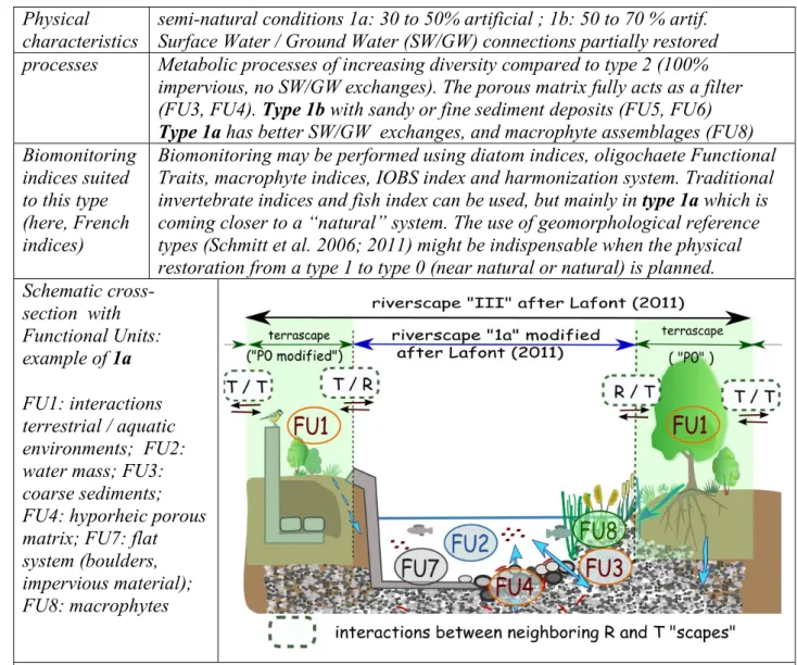
Physical
characteristics
semi-natural conditions 1a: 30 to 50% artificial ; 1b: 50 to 70 % artif.
Surface Water / Ground Water (SW/GW) connections partially restored
processes
Metabolic processes of increasing diversity compared to type 2 (100%
impervious, no SW/GW exchanges). The porous matrix fully acts as a filter
(FU3, FU4). Type 1b with sandy or fine sediment deposits (FU5, FU6)
Type 1a has better SW/GW exchanges, and macrophyte assemblages (FU8)
Biomonitoring
indices suited
to this type
(here, French
indices)
Biomonitoring may be performed using diatom indices, oligochaete Functional
Traits, macrophyte indices, IOBS index and harmonization system. Traditional
invertebrate indices and fish index can be used, but mainly in type 1a which is
coming closer to a “natural” system. The use of geomorphological reference
types (Schmitt et al. 2006; 2011) might be indispensable when the physical
restoration from a type 1 to type 0 (near natural or natural) is planned.
Schematic
cross-section with
Functional Units:
example of 1a
FU1: interactions
terrestrial / aquatic
environments; FU2:
water mass; FU3:
coarse sediments;
FU4: hyporheic porous
matrix; FU7: flat
system (boulders,
impervious material);
FU8: macrophytes
Table 1: new description of a riverscape, based on functional units, where terrestrial units (FU1)
are excluded to be addressed separately as “terrascapes” ; modified after Lafont (2011),
Differences with better type (0) and more degraded (2) are explicitly mentioned and described.
Physical
characteri
stics of
“P” type
P0 (natural riverine habitat): simple description: “characterized by patches of
habitats, trees + bushes + grassed areas” ; finer specialized description (…) ,
P1: natural landscape like P0 but located within a dam bowl: subjected to enhanced
(and
subtypes)
possible sediment deposit…).
Possible shifts: P0 <=> P1(construction/removal of a dry dam) ; P0, P1 <=> A
(A= agricultural area outside dam bowl, Ab =within dam bowl…)
Links with
other
“scapes”
Positive interaction of P0 and P1:
(+) with the other nearby natural patches (connected better than isolated)
To the river: (+) P0 and P1: input of organic matter, shade ; (-) Ab:
possible pollution of cultivated land by chemicals or fine sediments
(+ ) From the river to types P: water, food for birds
Represent
ative
photos
P1 in normal state vs flooded conditions
P1: blocks deposited after flood event
Table 2: Possible description of “terrascape” type and sub-types suited for a dry dam bowl
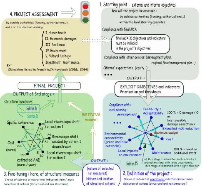
Poster 2: Our previous works focused on dry dams, and concertation consisted in choosing the
“best attainable riverscapes”, to reduce the negative impacts on the river. Poster 2 proposes to
generalize the concertation process, from earlier stages (choice of action) and ensure
compatibility with the final criteria assessment. Our working hypothesis is that
multi-criteria analysis can provide a good framework for decision-making at all stages. To improve a
project, the scores for every criterion are useful: a total score would hide the specificities. Radar
graphs appear very appropriate to display these results in a synthetic way, and thus discuss and
compare solutions (e.g. Edjossan-Sossou et al., 2014.). Table 3 gives an idea of how MCA could
be used and adapted throughout a project, from to definition of the project to the design stages.
The prerequisite is an explicit list of the project manager’s objectives (stage1). They should be
compatible with the local and national policies when relevant, and comply with the requirement
from authorities or funding institutions. In the early stages, we need a very pragmatic and
simplified form of MCA. As the project progresses from one stage to another, criteria are
refined, other are removed because they are insensitive to the remaining choices, but always in
good agreement with the other stages, in particular with the MCA used to assess the final project
(for internal decision-making and/or to obtain authorizations or funds). Table 3 tackles practical
problems: how to define the minimum and maximum for each criterion (absolute or relative
values ? how to account for uncertainty ?…) ; the examples shown here illustrate the issue but of
course in each case the choices have to be made by the people involved in the project. Poster 1
deals with stage 3, after the actions are chosen (dry dams, in our case); the impact of individual
actions are measured by the shifts in riverscapes. We added here an indicator of the overall
impact at the scale of the catchment, based on the respect of green and blue networks
Table 3: Possible evolution of criteria displayed on radar graphs from early to final stages
Discussion
Although explicit objectives seem a prerequisite to any project, obtaining an exhaustive list of all
the decision criteria that will be used might remain difficult. We also need an idea of the
priorities, i.e. weights given to reach indicator, and thresholds (for a given criterion, can “poor”
be tolerable if the other criteria are excellent, or not). Furthermore, there is no standard method
to define synthetic “environmental indicators”. In France, the national guidelines on MCA for
flood risk mitigation projects list as “environmental indicators” only accidental pollutions of the
environment caused by flooded facilities (CGDD, 2014). However, they announce on-going
works, and “standard” environmental indicators should be given in a near future. Finally, to draft
a project, we should not forget common-sense criteria like “feasibility” – including time-scale,
acceptability, partnerships…- can also be very determining.
Another major difficulty is the assessment of indicators in early stages: only estimations can be
reasonably provided. Table 3 suggests a “best situation” be defined, thus the score could be a
percentage of this optimum. Similarly, the reliability of assessment is an interesting information:
therefore, an expected score can be usefully completed by a range of uncertainty.
All these objectives remain theoretical and cannot be achieved if not supported by a
transdisciplinary team, including in particular end-users from public and/or private organisms
(Lafont, 2011; Lafont et al., 2010; 2012; Tixier et al,. 2012; Vivien et al., 2014). Practitioners
who will be in charge of technical achievement or maintenance should also bring their expertise
throughout the project: they can be aware of what is feasible and what is not, and of technical
alternatives. Concerning public participation, we suggest it should take place in the early stages,
and in particular in the definition of objectives to ensure public acceptance.
We insist on the necessity for the transdisciplinary team to follow and share the same conceptual
and operational approaches, for example the riverscape typology, and that aslo includes guides
for end-users (Lafont, 2011). Conceptual and operational phases are linked approaches, and have
to be accepted and shared by the team. The triad [project/approaches/team] seems in our opinion
a key to the success, because it constitutes the indispensable cement for the complete
development of a given project. The triad differs from a project to another: other concepts, teams
and end-users (Gaillard, 1997).
Conclusions
The idea is to make the best use of the competences of each involved person, including technical
staffs. Co-conception implies the active participation of all. Therefore, our approach insists that
first the objectives have to be explicit and shared, and that solutions must be found to discuss
and compare the means of action, using common conceptual and operational views.
Our approach still has to be implemented for full-scale studies, in real and varied contexts, to test
and improve the method to a fully operational stage. Only then can “guidelines’ be written, but
always allowing much freedom in the implementation. Future implementations should be
followed closely, certainly not to control the process, but to capitalize on the experience. Social
sciences should be closely associated to the project, to analyze the paths towards solutions: how
different specialists collaborate, which were the expected and unexpected misunderstandings at
the beginning, how they were identified and solved, how compromises were made, how each
specialist around the table really influenced the final version of the project. Of course, each
project is different, but feed-back analysis can always bring insight to the delicate art of project
management and help identify obstacles and solutions for fruitful co-conception (Lafont 2011;
Richard-Ferroudji, 2014).
Acknowledgements
This study started in collaboration between Irstea and Cracow University of Technology thanks
to funding from PHC bilateral projects and EcoNet 3-partner projects.
References
Cavaillé, P., Dommanget, F., Daumergue, N., Loucougaray, G., Spiegelberger, T., Tabacchi, E., Evette, A., 2013. Biodiversity assessment following a naturality gradient of riverbank protection structures in French prealps rivers. Ecological Engineering, 53: 23-30.
CGDD, 2014. Analyse multicritères des projets de prévention des inondations - Guide méthodologique. RéférenceS. Ministère de d'Ecologie, du Développement Durable et de l'Energie: 86. (http://www.developpement-durable.gouv.fr/IMG/pdf/Ref_-_Guide_AMC_inondations.pdf)
Edjossan-Sossou, A. M., Deck, O., Al Heib, M., Verdel, T., 2014. A decision-support methodology for assessing the sustainability of natural risk management strategies in urban areas. Nat. Hazards Earth Syst. Sci. 14(12): 3207-3230.
Gaillard, J.M. 1997. Marketing et gestion de la Recherche et Développement. Collection Recherche en Gestion, Economica, Paris, 336 pp.
Junk W.J., Bayley P.B., Sparks R.E., 1989. The flood pulse concept in river-floodplain systems. Can. Spec. Publ. Fish. Aquat. Sci., 106, 110-127.
Koutecký, P., Prach, K., 2005. Recovery of alluvial meadows after an extreme summer flood: A case study. Ecohydrology and Hydrobiology 5(1): 33-39.
Lafont M, Jézéquel C., Vivier A., Breil P., Schmitt L., Bernoud, S., 2010. Refinement of biomonitoring of urban water courses by combining descriptive and ecohydrological approaches. Ecohydrol. Hydrobiol., 10: 3-11.
Lafont, M., Tixier, G., Marsalek, J., Jézéquel, C., Breil, P., Schmitt, L., 2012. From Research to Operational Biomonitoring of Freshwaters: A Suggested Conceptual Framework and Practical Solutions. Ecohydrol. Hydrobiol., 12 (1): 9-20.
Malard, F., Uehlinger, U., Zah R., Tockner, K., 2006. Flood-pulse and riverscape dynamics in a braided glacial river. Ecology, 87, 704-716.
Merritt, D.M., Nilsson, C. and Jansson, R,. 2010. Consequences of propagule dispersal and river fragmentation for riparian plant community diversity and turnover. Ecological Monographs, 80:609-626.
Poulard, C., Lenar-Matyas, A., Łapuszek, M., Lafont, M., Schmitt, L., Jézéquel, C., Breil, P., 2011. Co-conception of integrated flood management solutions: riverscapes to facilitate dialog. Ecohydrology & Hydrobiology 11(1–2), 107-119.
Poulard, C., Breil, P., Lafont, M., 2013. Gérer les crues et les inondations, in: Chocat, B. (Ed), Ingénierie écologique appliquée aux milieux aquatiques ; pourquoi ? comment ? ASTEE, Paris, pp. 68-83. Poulard C., Royet R., Ratomski J., Lenar-Matyas A., 2009. Dams with open outlets for flood control:
some lessons to be learnt since 1905 (in French), Ingénieries EAT, Special Issue on Flood Prevention, 33-53.
Poulard, C., Lafont, M., Lenar-Matyas A., Łapuszek, M., 2010. Flood mitigation designs with respect to river ecosystem functions - a problem oriented conceptual approach. Ecol. Eng., 36(1), 69-77.
Richard-Ferroudji, A., 2014. Rare birds for fuzzy jobs: A new type of water professional at the watershed scale in France. Journal of Hydrology 519, Part C(0): 2468-2474.
Schmitt, L., Valette, L., Valin, K., Piegay, H. and Hallot, E., 2006. Proposition d’une méthode de typologie hydro-géomorphologique des cours d’eau et test sur un sous-bassin du Rhône (bassin de l’Yzeron). Mosella, XXIX, 3-4, 2006, p. 323-340.
Schmitt L., Lafont M., Trémolières M., Jezequel C., Vivier A., Breil P., Namour P., Valin K., Valette L., 2011. Using hydro-geomorphological typologies in functional ecology: preliminary results in contrasted hydrosystems. Physics and Chemistry of the Earth, 36, 539-548.
Tixier G., Rochfort Q, Grapentine L., Marsalek J., Lafont M., 2012. Spatial and seasonal toxicity in a stormwater management facility: Evidence obtained by adapting an integrated sediment quality assessment approach. Water Research, 46: 6671-6682.
Vivien R., Tixier G., Lafont M., 2014. Use of oligochaete communities for assessing the quality of sediments in watercourses of the Geneva area (Switzerland) and Artois-Picardie basin (France): proposition of heavy metal toxicity thresholds. Ecohydrol. Hydrobiol., 14 (2): 142-151.