DYNAMIQUE ÉCOHYDROLOGIQUE ET SÉQUESTRATION DU CARBONE AU COURS DE L'HOLOCÈNE DANS LES TOURBIÈRES OMBROTROPHES
MARITIMES DE L'ESTUAIRE ET DU GOLFE DU SAINT-LAURENT
THÈSE
PRÉSENTÉE
COMME EXIGENCE PARTIELLE
DU DOCTORAT EN SCIENCES DE L'ENVIRONNEMENT
PAR
GABRIEL MAGNAN
UNIVERSITÉ DU QUÉBEC À MONTRÉAL Service des bibliothèques
Avertissement
La diffusion de cette thèse se fait dans le respect des droits de son auteur, qui a signé le formulaire Autorisation de reproduire et de diffuser un travail de recherche de cycles supérieurs (SDU-522- Rév.01-2006). Cette autorisation stipule que «conformément à l'article 11 du Règlement no 8 des études de cycles supérieurs, [l'auteur] concède à l'Université du Québec à Montréal une licence non exclusive d'utilisation et de publication de la totalité ou d'une partie importante de [son] travail de recherche pour des fins pédagogiques et non commerciales. Plus précisément, [rauteur] autorise l'Université du Québec à Montréal à reproduire, diffuser, prêter, distribuer ou vendre des copies de [son] travail de recherche à des fins non commerciales sur quelque support que ce soit, y compris l'Internet. Cette licence et cette autorisation n'entraînent pas une renonciation de [la] part [de l'auteur] à [ses] droits moraux ni à [ses] droits de propriété intellectuelle. Sauf entente contraire, [l'auteur] conserve la liberté de diffuser et de commercialiser ou non ce travail dont [il] possède un exemplaire.»
La thèse est composée de trois articles scientifiques rédigés en anglais qui ont été soumis à des revues scientifiques internationales avec comité de lecture. Les autres sections de la thèse sont rédigées en français selon les exigences de l'Université du Québec à Montréal. J'ai agi à titre de premier auteur pour les trois articles (chapitres), ce qui signifie que j'ai été le principal responsable de la collecte des données, des analyses en laboratoire, de l'interprétation des données et de la rédaction. Ma directrice de thèse Michelle Garneau est deuxième auteure des trois articles composant la thèse. Mon directeur Serge Payette (Université Laval) est co-auteur du Chapitre 1 portant sur le développement à long terme des tourbières. Afin de faciliter la lecture individuelle de chaque chapitre, les articles ont été conservés dans leur intégralité ce qui entraîne certaines répétitions notamment dans les sections décrivant les régions et sites d'étude et la méthodologie.
REMERCIEMENTS
Je tiens à remercier ma directrice de thèse Michelle Garneau qui m'a donné l'opportunité de travailler sur un projet passionnant au sein d'une équipe de recherche exceptionnelle. Par sa disponibilité, sa compréhension et sa passion, elle a toujours su me soutenir au cours de la réalisation de cette thèse. Un grand rrierci à mon co-directeur Serge Payette qui a toujours été une grande source d'inspiration et de motivation pour moi depuis mes débuts en recherche, ce fut un grand privilège de pouvoir le côtoyer et de bénéficier de sa grande expertise. Je veux souligner le grand soutien des membres du groupe les Tourbeux, en particulier Hans Asnong, Alexandre Lamarre, Antoine Thibault, Steve Pratte et Simon van Bellen. Je suis aussi très reconnaissant envers Jean-Baptiste Plouhinec qui m'a beaucoup aidé dans la conceptualisation et la modélisation de la dynamique du carbone. Je tiens également à saluer le travail exceptionnel des assistants de terrain et de laboratoire qui ont participé à ce projet : Alexandre Turcotte, Sebastien, Lacoste, Arabelle Sauvé, Julien Beaudet, Annie Lamalice et Jean-Pierre Bélanger. Enfm, le parcours menant à la réalisation de ce doctorat n'aurait jamais été le même sans le support constant de ma conjointe Sandra, de mes parents Michel et Nicole et de ma sœur Laurie. J'ai aussi eu la chance de bénéficier d'un soutien financier du FQRNT, du CRNSG ainsi que d'Hydro-Québec sous forme de bourses personnelles ou de subventions de recherche.
AVANT-PROPOS ... ii
LISTE DE FIGURES ... viii
LISTE DES TABLEAUX ... xi
LISTE DES ABRÉVIATIONS ET ACRONYMES ... xii
RÉSUMÉ ... xiv
ABSTRACT ... xvi
INTRODUCTION .. ... ... ... ... .... ... ... ... ... ... .... ... ... .. .... ... ... 1
CHAPITRE I HOLOCENE DEVELOPMENT OF MARITIME OMBROTROPHIC PEATLANDS ALONG THE ESTUARY AND GULF OF ST. LAWRENCE IN EASTERN CANADA ... 12
1.1. Introduction . . . .. . . .. . . .. . . 15
1.2. Methods ... 17
1.2.1. Study are a and sites ... .... ... .. ... ... ... ... .. .... ... ... 17
1.2.2. Field work ... ... ... .. .... ... .. .... ... ... ... .... ... .... ... ... .. ... ... ... ... . .. 17
1.2.3. Plant macrofossil analyses ... 18
1.2.4. Chronology ... .... ... .. .... ... ... ... ... ... .. ... ... ... ... 19
1.2.5. Charcoal analyses ... 20
1.3. Results ... 21
1.3 .1. Vegetation successions and fi re his tory in Lebel peatland . . . 21 1.3.2. Vegetation successions and fire history in Plaine peatland ... 22
1.3.3. Vegetation successions in Baie peatland ... 23 1.3.4. Vegetation successions in Morts peatland ... 23
v 1.4.1. Role of internai and external factors on long-term peatland
development .. . .. .. . .. .. . .. .. .. . . .. .. .. .. . .. .. .. . .. .. .. . .. .. .. .. .. . .. . .. .. .. .. .. .. . .. .. .. .. .. .. . . .. . . 24
1.4.2. Earl y vegetation successions and pa th ways to ombrotrophy ... 26
1.4.3. Vegetation successions and fire dynamics within the bogs ... 27
1.5. Conclusion ... 28
CHAPITRE II EVALUATING LONG-TERM REGIONAL CLIMATIC VARIABILITY IN THE MARITIME REGION OF THE ST. LA WREN CE NORTH SHORE (EASTERN CANADA) USING A MULTI-SITE COMPARISON OF PEAT-BASED PALEOHYDROLOGICAL RECORDS ... 47
2.1. Introduction ... 50
2.2. Study region ... 51
2.3. Methods ... 52·
2.3 .1. Field sampling ... 52
2.3.2. Chronology ... 53
2.3.3. Testate amoeba analyses ... 53
2.3.4. Past water table depth reconstructions ... 54
2.3.5. Ordination with DCA ... 55
2.4. Results ... 55
2.4.1. DCA ordination of the fossil assemblages ... 55
2.4.2. Paleohydrological reconstruction of Lebel bog ... 56
2.4.3. Paleohydrological reconstruction of Baie bog ... 57
2.4.4. Paleohydrological reconstruction of Plaine bog ... 57
2.4.5 Paleohydrological reconstruction of Morts bog ... 58
2.4.6. Multi-site comparison of the water table records ... 58
2.5. Discussion ... ~ ... 59
2.5.1. Detecting climate forcing using peat-based paleohydrological records ... 59
2.5.2. Comparison of the paleohydrological variability with mid-to late
Holocene climate changes in northeastern Canada ... 61
2.5.3. Paleoclimatic interpretation ofwater table variability in the bogs of the St. Lawrence North Shore ... 62
2.6. Conclusion ... 64
CHAPITRE III A REGIONAL COMPARISON OF THE LONG-TERM CARBON DYNAMICS WITHIN MARITIME OMBROTROPHIC PEATLANDS ALONG THE NORTH SHORE OF THE ESTUARY AND GULF OF ST. LAWRENCE, EASTERN CANADA ... 82
3.1. Introduction ... 85
3.2. Methods ... 87
3 .2.1. Study area and sites ... 87
3.2.2. Field sampling ... 88
3 .2.3. Radiocarbon da ting and chronology ... 88
3 .2.4. Organic matter and C data ... 89
3.2.5. Peat humification and paleohydrological records ... 89
3.3. Results ... 90
3.3.1. Long-term apparent rates ofC accumulation (LORCA) ... 90
3.3.2. Long-term patterns ofC sequestration ... 91
3.3.3. Temporal variations in C accumulation rates (CAR) ... 91
3.3.4. Relationship between C accumulation and paleohydrological variability . . . . .. . . .. . . 92 3.4. Discussion ... 93
3.4.1. Holocene C sequestration between the two regions ... 93
3.4.2. Long-term patterns ofC accumulation ... 93
3.4.3. Processes controlling the long-term C balance ... 94
3 .4.4. Role of climate on the C sequestration over the Holocene ... 95
Vll
CONCLUSION GÉNÉRALE ... 112 RÉFÉRENCES ... 118
Figure
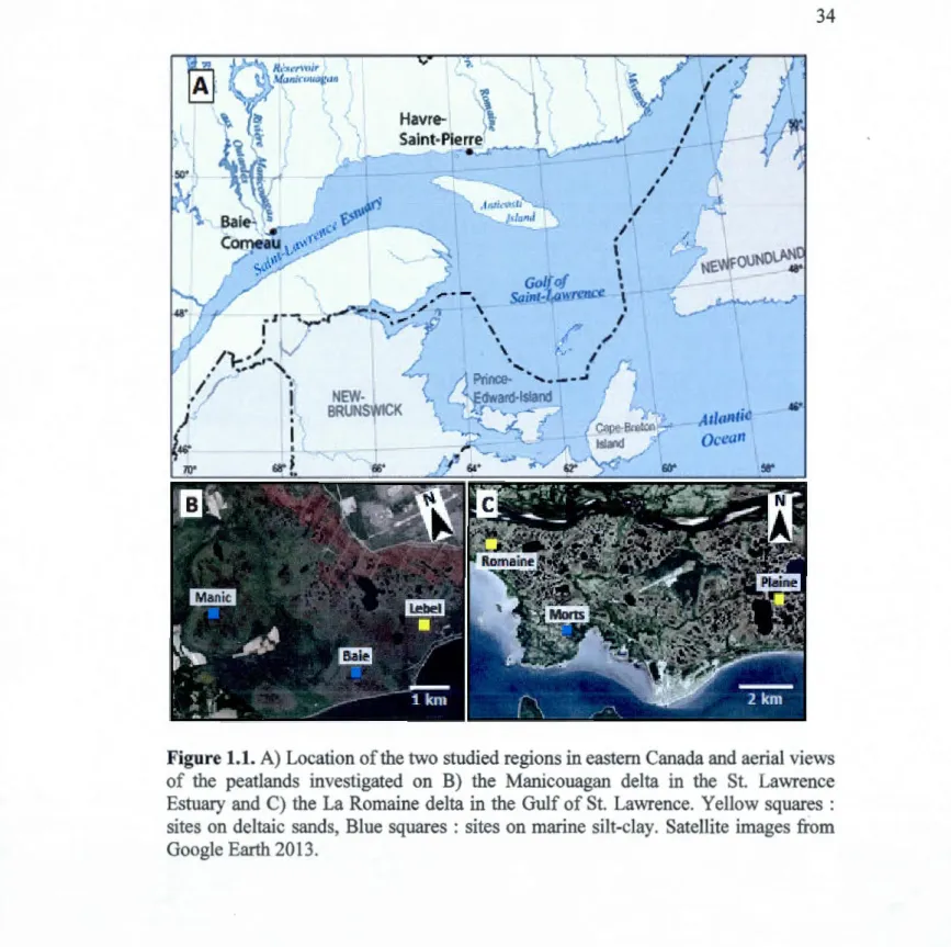
1.1 A) Location of the two studied regions in eastern Canada and aerial views of the peatlands investigated on B) the Manicouagan delta in the St. Lawrence Estuary and C) the La Romaine delta in the Gulf of St. Lawrence. Y ellow squares : sites on deltaic sands, Blue squares :
Page
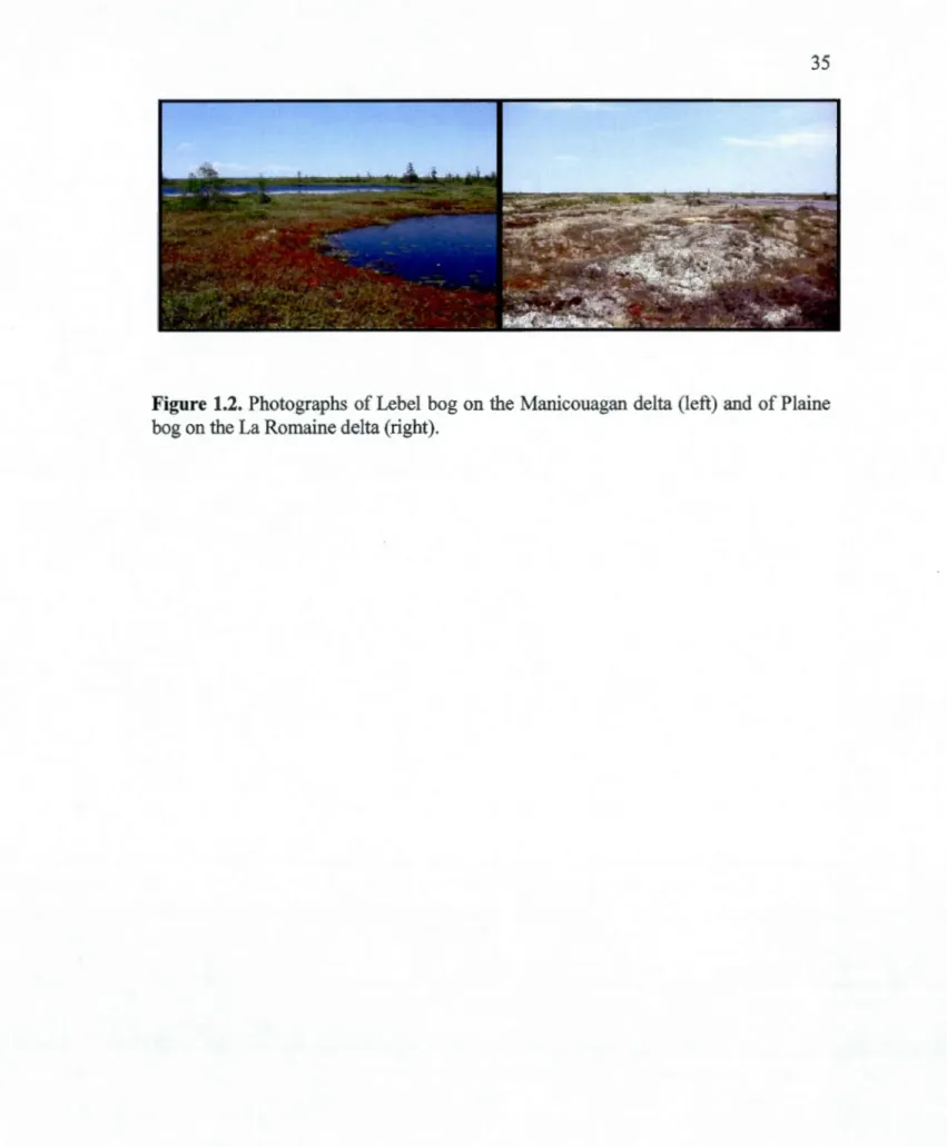
sites on marine silt-clay. Satellite images from Google Earth 2013 ... 34 · 1.2 Photographs of Lebel bog on the Manicouagan delta (left) and of
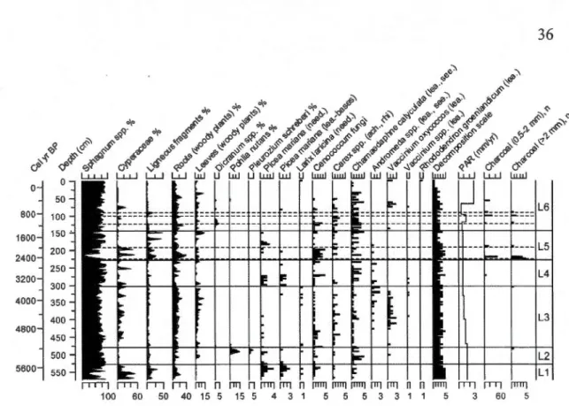
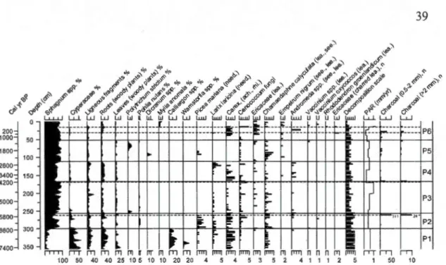
Plaine bog on the La Romaine delta (right) ... 35 1.3 Plant macrofossil diagram of Lebel bog. Dashed lines show the fire
events. The bars represent the scale of abundance (1 = rare, 5= abundant). need-needles, ach-achenes, rhiz-rhizomes, lea-leaves,
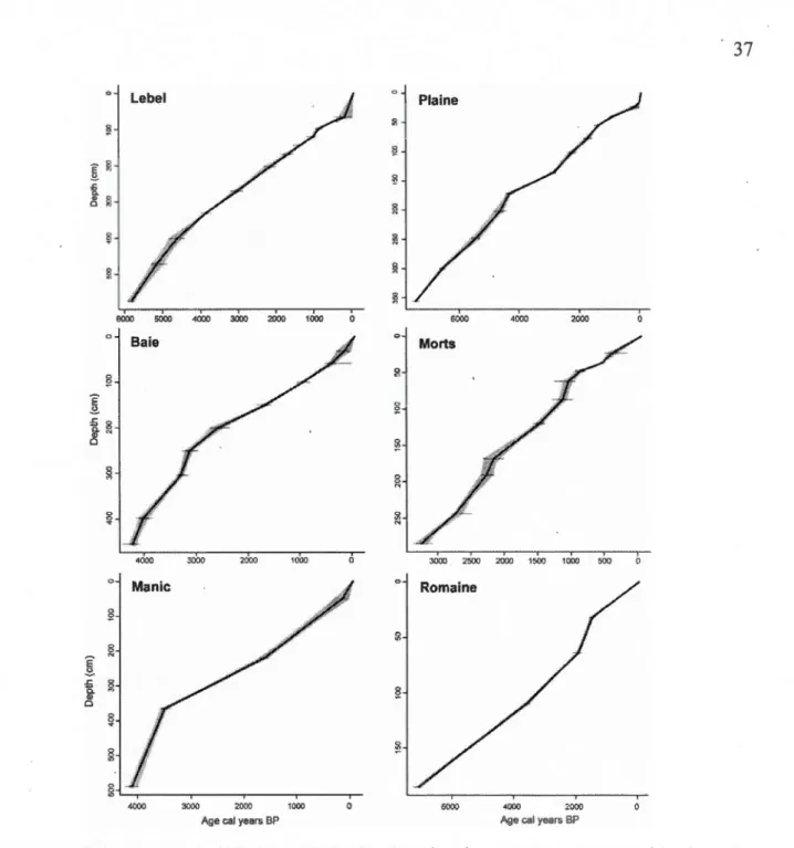
see-seeds, PAR-Peat accumulation rates ... 36 1.4 Age-depth models developed using Clam software with the 95%
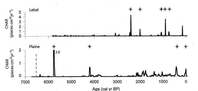
confidence intervals for the six studied peat1ands ... 3 7 1.5 Charcoal accumulation rates (CHAR). The "+" symbol shows the
identified fire horizons comprising large charcoal particles >2 mm.
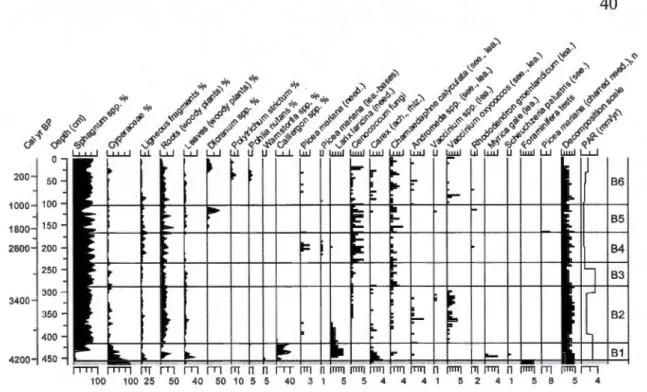
The vertical dashed line show the fen-bog transition in Plaine ... 38 1.6 Plant macrofossil diagram of Plaine bog. Dashed lines show the fire
events. The bars represent the scale of abundance (1 = rare, 5= abundant). need-needles, ach-achenes, rhiz-rhizomes, lea-leaves,
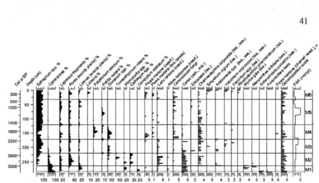
see-seeds, PAR-Peat accumulation rates . ... 39 1. 7 Plant macrofossil diagram of Baie bog. The bars represent the scale
of abundance (1 = rare, 5= abundant). need-needles, ach-achenes, rhiz-rhizomes, lea-leaves, see-seeds, PAR-Peat accumulation rates. The grey rectangle shows the lower peat section with high mineral
content (>50%) . ... 40 1.8 Plant macrofossil diagram of Morts peatland. The bars represent the
scale of abundance (1 = rare, 5= abundant). need-needles, ach -achenes, rhiz-rhizomes, lea-leaves, see-seeds, P AR-Peat accumulation rates. The grey rectangle shows the lower peat section
lX
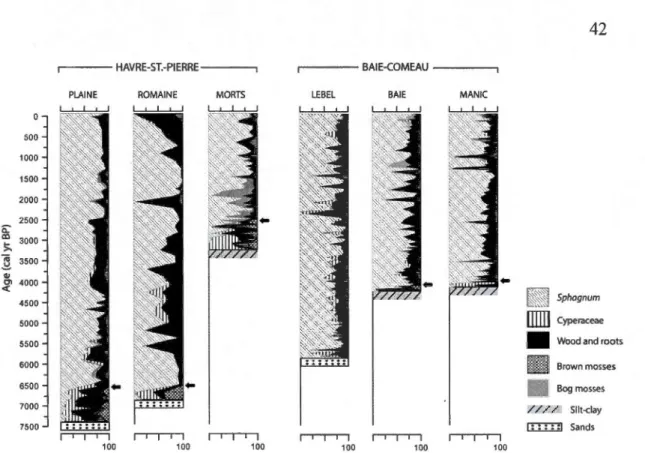
1.9 Synthesis of the peatland vegetation types for the six studied peat
cores. The fen-bog transition is shown by the black arrows . ... 42 2.1 Location of the two study area and of the coring sites within the four
studied peatlands along the St. Lawrence North Shore on A) the Manicouagan delta (BC) and B) the La Romaine delta (HSP).
Source: Satellite images from Google Barth 2013 ... 71 2.2 Age-depth models developed using Clam software by applying
linear interpolation with the 95% confidence intervals for the four
studied peat records ... 72 2.3 DCA ordination of the fossil testa te amoebae data ... 73 2.4 Testate amoebae diagram (%) of Lebel peatland (BC). Peat types :
Sphagnum (diagonal lines), other bog mosses (light grey),
Cyperaceae (white), ligneous (dark grey) and brown mosses (black) . ... 74 2.5 Testate amoebae diagram (%) of Baie peatland (BC). Peat types :
Sphagnum (diagonal lines), other bog mosses (light grey), Cyperaceae (white), ligneous (dark grey) and brown mosses (black) ... 75 2.6 Testate amoebae diagram (%) of Plaine peatland (HSP). Peat types :
Sphagnum (diagonal !ines), other bog mosses (light grey),
Cyperaceae (white), ligneous (dark grey) and brown mosses (black) . ... 76 2.7 Testate amoebae diagram (%) of Morts peatland (HSP). Peat types :
Sphagnum (diagonal lines), other bog mosses (light grey),
Cyperaceae (white), ligneous (dark grey) and brown mosses (black) ... 77 2.8 Comparison of the four water table depth records for the last 6000
cal years BP with sample-specific standard errors. The shaded boxes show the common late-Holocene period of increased hydrological variability and drier conditions in each region. The black arrows
show the fen-bog transition in Baie and Morts ... 78 2.9 Synthesis of the WTD variations since 4200 cal BP from the four
peat cores. Data were pooled into 200-year bins. The box plots show the lower and upper quartile, median and outliers. The combined record (A) is compared with the surface wetness record (BSW) from Nordan's pond bog in Newfoundland (B) (Hughes et al., 2006). The
3.1 A) Location of the two studied regions along the St. Lawrence North Shore in eastern Canada and aerial views of the studied peatlands on B) the Manicouagan delta near Baie-Comeau and C) the La Romaine delta near Havre-St-Pierre. Yellow squares : sites on deltaic sands,
Blue squares : sites on marine silt-clay. Source: aerial views from
Google Earth 2013. . . . .. . . .. . . .. . . 1 03 3.2 Relationship between the age of peat inception and the LORCA
values with standard deviations for the peatlands of Havre-St-Pierre (circles) and Baie-Comeau (squares) that are underlain by deltaic
sands (open symbols) or silt-clay deposits (filled symbols ). ... ... . ... 104 3.3 Cumulative C mass versus age curves for the six peatlands with
age-depth models from Havre-St-Pierre (dashed line) and Baie-Comeau
( continuous line). . . .. . . 1 0 5 3.4 Long-term rates of C accumulation (LORCA) since 2000 and 1000
cal years BP for the six studied peatlands. .. . . .. . . .. 106 3.5 Temporal variations in the rates of C accumulation (CAR; mean
value between each 14C date). The age of the fen-bog transition is
indicated by a triangle. . . . 107 3.6 Comparison of the C accumulation rates (CAR) with peat vegetation
types, water table depth (WTD) and peat humification (Light-transmission, LT) from Plaine and Lebel bog. The timing of the
LISTE DES
TABLEAUX
Tableau Pages
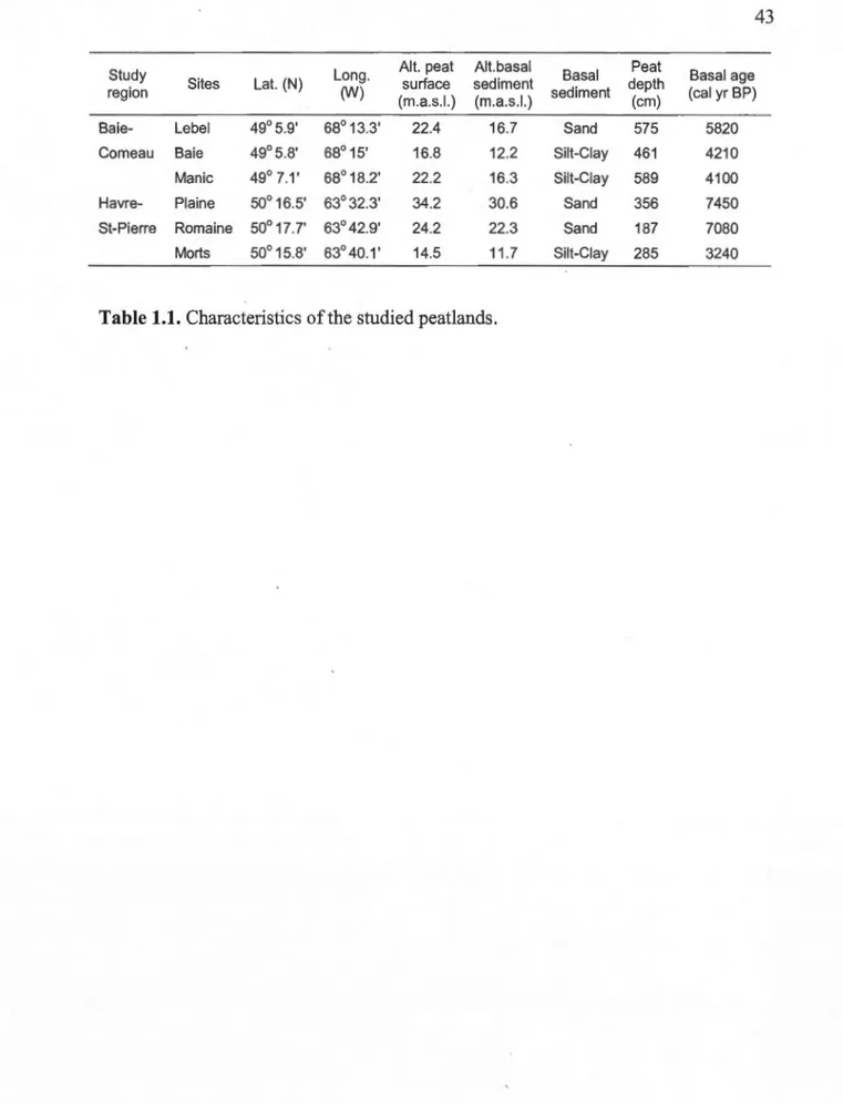
1.1 Characteristics of the studied peatlands ... 43
1.2 Radiocarbon dates ... 44
1.3 Macrofossil dia gram zonation for the four main peat profiles ... 46
2.1 Radiocarbon dates . ... 80
2.2 Details of the testate amoebae diagram zonation for the four peat records . ... 81
3.1 Radiocarbon dates. . . . .. . . 109
3.2 Description of the eight peat profiles with peat and C accumulation data ... 111
AD AMS m. a.s.l. BC BP BSW
c
I4c CalBP CAR CHARco2
CH4 DCA DGPS étal. BP Gt HSP ka LIA LOIAnno domini, années après Jésus-Christ
Accelerator mass spectrometry
Meters above sea level
Baie-Comeau
Before present (avant l'actuel, i.e. AD 1950)
Bog surface wetness
Carbone Radiocarbone
calibrated years before present (AD 1950)
Carbon accumulation rates
Charcoal accumulation rates Dioxide de carbone
Méthane
Detrended correspondence analyses
Differentiai Global Positioning System
Étalonnées avant AD 1950
Gigatonnes
Havre-Saint-Pierre
kiloannum (milliers d'années BP)
Little lee Age
LORCA LOWESS MAP MAT MCA NPP NLWIS OM RMSEP SE SD sp. spp. WTD
Long-term average apparent rate of carbon accumulation Locally weighted regression smoothing
Mean Annual Precipitation Mean Annual Temperature Medieval Climate Anomaly Net Primary Production
National Land and Water Information Service Organic Matter
Root-Mean-Square Error of Prediction Standard Error
Standard deviation Species (singulier) Species (pluriel) Water Table Depth
Les tourbières nordiques représentent l'un des plus importants puits terrestres de carbone (C) organique et sont aussi d'importantes sources de gaz à effet de serre. Afin de mieux comprendre entièrement le rôle des tourbières dans le cycle global du C, il est essentiel d'améliorer les connaissances sur les processus contrôlant 1' accumulation à long terme du C dans ces écosystèmes à 1 'échelle régionale. Au cours des millénaires, l'accumulation du C dans les tourbières est influencée par une combinaison de facteurs internes ( e.g. topographie du bassin) et externes ( e.g. climat, feux). Cette thèse vise à évaluer 1 'influence de la variabilité climatique holocène sur la dynamique du C dans les tourbières maritimes de la région de la Côte-Nord dans 1' est du Canada. Les tourbières ombrotrophes (bogs) sont répandues sur les deltas postglaciaires le long de l'estuaire et du golfe du St. Laurent où elles représentent d'importantes composantes hydrologiques et écologiques au sein des environnements côtiers. Dans ce projet, le rôle du climat sur le développement à long terme de ces tourbières a été évalué en utilisant une approche comparative multi-sites entre deux régions écoclimatiques (boréal et subarctique) près de Baie-Comeau (BC) et Havre-St-Pierre (HSP). La séquestration du C au cours de l'Holocène a été évaluée en calculant les taux apparents d'accumulation à long terme du C (LORCA) au sein de huit tourbières. Les variations temporelles de séquestration du C ont été comparées aux reconstitutions écohydrologiques basées sur l'analyse des macrorestes végétaux et des thécamoebiens fossiles. L'influence des feux a aussi été déterminée par l'analyse à haute résolution des charbons de bois macroscopiques.
Sur la Côte-Nord, la chronologie de formation des tourbières est étroitement liée aux fluctuations holocènes des niveaux marins. L'accumulation de la tourbe s'est amorcée sur les terrasses deltaïques sableuses suite au retrait de la Mer de Goldthwait à partir de 7500 ans étal. BP et au-dessus des dépôts silto-argileux associés à la transgression marine laurentienne après 4200 ans étal. BP.
Cette thèse a montré plusieurs évidences de l'influence climatique sur la dynamique écohydrologique des tourbières au cours de l'Holocène. Le rythme des successions végétales initiales semble avoir été indirectement influencé par des conditions climatiques régionales distinctes. La transition vers 1' ombrotrophie est survenue plus rapidement dans la région de Baie-Comeau, favorisée par une accumulation rapide de la tourbe, une indication que le climat était plus propice au développement des tourbières dans cette regwn. De plus, les données paleohydrologiques montrent des périodes cohérentes de changements à l'échelle régionale correspondant à des phases climatiques documentées dans le nord-est du Canada. L'assèchement des surfaces des bogs et des conditions hydrologiques plus variables après 3000 ans étal. BP coïncident avec la transition entre 1' optimum climatique holocène et le refroidissement Néoglaciaire.
xv
Le climat de la Côte-Nord, caractérisé par une faible évapotranspiration et une humidité atmosphérique élevée, a favorisé une croissance soutenue des sphaignes au cours des phases ombrotrophes. Les feux locaux ont été rares (intervalles de feux : 1160 ans à Lebel et 1640 ans à Plaine) et dans l'ensemble ils ont eu peu d'impacts sur la végétation de surface tels que l'élimination des épinettes noires (Picea mariana) et l'introduction de mousses typiques des buttes de milieux ombrotrophes.
Au cours de l'Holocène, la différence des taux d'accumulation du C entre Havre-St-Pierre (LORCA: 16-46 g m-2 yr"1) et Baie-Comeau (LORCA: 53-68 g m-2 yr"1) suggère un contrôle climatique régional sur le bilan à long terme du C. Les taux d'accumulation duC plus élevés et plus stables dans les bogs de Baie-Comeau ont été favorisés par une stabilité des conditions hydrologiques. En contrepartie, les bogs de Havre-St-Pierre ont connu d'importantes variations d'accumulation du C associées notamment à des variations marquées des nappes phréatiques. Cette différence révèle une plus grande sensibilité des tourbières de Havre-St-Pierre aux changements climatiques passés, spécialement au cours du Néoglaciaire lorsque leur hydrologie et leur végétation semblent avoir été affectées par des saisons de croissance plus courtes et possiblement une influence accrue du gel saisonnier. La diminution graduelle de séquestration du C dans les tourbières étudiées résulte d'une influence combinée du développement vertical autogène et des changements climatiques régionaux survenus au cours de l'Holocène récent.
Les résultats suggèrent en effet que les trajectoires du développement holocène des tourbières ont été ultimement contrôlées par le climat mais plusieurs changements écohydrologiques à l'échelle décennale et centenaire semblent résulter principalement de processus internes. Les patrons distincts de variations des taux de séquestration du C entre les sites suggèrent que des facteurs internes de chaque tourbière ont affecté le bilan net d'accumulation du C. L'influence du climat sur le bilan à long terme du C dans les tourbières de la Côte-Nord s'est fait par l'intermédiaire d'interactions complexes entre les processus d'accumulation et de décomposition et les variations hydrologiques. Ces résultats sont conformes avec les modèles conceptuels et suggèrent que la dynamique des tourbières est aussi influencée par des processus autogènes et des mécanismes de rétroaction écohydrologiques.
Mots clés Tourbières ombrotrophes, Holocène, carbone, paléoécologie, paléohydrologie
N orthern peatlands are one of the largest terres trial sink of organic carbon ( C) and are important sources of greenhouse gases. In order to understand past and future roles of peatlands in the global
c cycle, it is essential to improve knowledge on the
processes controlling the long-term C sequestration in these ecosystems at a regional scale. Over millennial timescales, peatland C accumulation is driven by a combination of internai ( e.g. basin topography) and external factors ( e.g. climate, fires). This thesis aims to evaluate the influence of Holocene climate variability on the C dynamics within the maritime peatlands of the Québec North Shore (eastern Canada). Ombrotrophic peatlands (bogs) are widespread on the postglacial deltas along the Estuary and Gulf of St. Lawrence and are major hydrological and ecological components within the coastal environments. In this project, the role of climate over their long-term development was evaluated using a comparative multi-site approach within two peatland complexes from two maritime ecoclimatic regions (boreal and subarctic) near Baie-Comeau (BC) and Havre-St-Pierre (HSP). The Holocene C sequestration was evaluated by calculating the long-term average rates of C accumulation (LORCA) within eight peatlands. The temporal variations in C sequestration were compared with the ecohydrological reconstructions based on plant macrofossils and testate amoebae analyses. The influence of fire was also evaluated using high-resolution macroscopic charcoal analyses.In the Québec North Shore, the timing of peat inception was closely associated with Holocene sea-level variations. Peat accumulation started over sandy deltaic terraces after the withdrawal of the Goldthwait Sea from 7500 cal yr BP and above silt-clay deposits associated to the Laurentian marine transgression after 4200 cal yr BP.
This thesis showed many evidences of climatic influences on the ecohydrological dynamics of the peatlands over the Holocene. The rates of early vegetation successions seem to have been indirectly influenced by distinct regional climatic conditions. The transitions to ombrotrophy have occurred much earlier in the peatlands of Baie-Comeau favored by faster initial rates of peat accumulation, an indication that climate conditions were more propitious to peat development in this region. Moreover, the paleohydrological data show coherent periods of changes at the regional scale which correspond to documented climate periods in northeastern Canada. The surface drying and increased hydrological variability in the bogs after 3000 cal yr BP coïncide with the transition from the Holocene Climatic Optimum to the Neoglacial cooling.
The climate of the St. Lawrence North Shore characterised by low evapotranspiration and high moisture inputs was very propitious to Sphagnum growth during the ombrotrophic stages. The local fires were rare within the bog stages
(fire-XVll
free intervals: 1160 yr in Lebel and 1640 yr in Plaine) and overall they had minor impacts on surface vegetation such as the removal of black spruce and the appearance
ofnon-Sphagnum mosses typical ofbog hummocks.
Over the Holocene, the difference in the C sequestration rates between Havre-St-Pierre (LORCA: 16-46 g m-2 y{1) and Baie-Comeau (LORCA: 53-68 g m-2 y{1) suggests a regional climatic control on the 1ong-terrn C balance. The higher and steadier rates of C accumulation in the bogs of Baie-Comeau were promoted by stable hydrological conditions which contrast with the bogs of Havre-St-Pierre that experienced high fluctuations in C sequestration related to marked shifts in water table levels. This reveals an increased sensitivity of these bogs to past hydroclimatic changes especially during the Neoglacial period when peatland hydrology and vegetation were likely affected by shorter growing seasons and possibly longer periods of seasona1 freezing. In the studied peatlands, the graduai slowdown in the rate of C production was driven by a combined influence of autogenic vertical development and regional climate change during the late-Holocene.
The results suggest that the long-term trajectories of peatland development were driven by climate but many decadal-to-centennial-scale changes in ecohydrological conditions seem to have resulted primarily from internai processes. The distinct patterns of C sequestration rates between sites suggest a complex response to regional climate variability. Our data suggest that the influence of climate on the long-terrn C balance was mediated by complex interactions between the accumulation/decay processes and the water table changes. These results are in line with conceptual models and suggest that peatland dynamics are also influenced by autogenic processes and ecohydrological feedback mechanisms.
Keywords : Ombrotrophic peatlands, Holocene, carbon dynamics, paleoecology, paleohydrology
Mise en contexte
Les tourbières couvrent environ 3% de la surface terrestre et sont principalement concentrées dans les régions boréales et subarctiques de l'hémisphère nord (Charman, 2002). Au Canada, ces écosystèmes occupent environ 12% du territoire ( ~ 1,1 million km2) et sont très abondants dans les Basse-terres de la Baie
d'Hudson et de James et dans les régions maritimes de l'est du pays (Tamocai, 2006). Les tourbières sont caractérisées par un bilan positif entre la production de biomasse et la décomposition de la matière organique qui en fait d'importants puits terrestres de carbone (C). Au cours de l'Holocène (derniers ~11 700 ans), les tourbières nordiques auraient entreposé environ 547 Gt de C (Yu et al., 2010) ce qui correspond à plus de 50 % duC contenu dans l'atmosphère terrestre (Frolking et Roulet, 2007) et au tiers du C organique contenu dans les sols de la planète (Gorham, 1991). Les tourbières représentent aussi d'importantes sources naturelles de méthane (Lelieveld, Crutzen et Dentener, 1998) et sont une composante majeure du cycle global du C et de sa rétroaction au sein des cycles climatiques planétaires.
Les tourbières ombrotrophes (bogs) qui sont alimentées uniquement par les précipitations atmosphériques ont un grand potentiel de séquestration du C (Clymo, Turunen et Tolonen, 1998 ; Turunen et al., 2002) notamment associé aux faibles taux de décomposition des sphaignes (Moore et Basiliko, 2006). Les bogs sont très répandus dans les régions maritimes côtières de l'est du Canada (Glaser and Janssens, 1986). Dans l'est du Québec, sur la Côte-Nord, de larges complexes de tourbières ombrotrophes se sont formées sur les dépôts fluvioglaciaires et deltaïques formés par les tributaires de la mer postglaciaire de Goldthwait (Bematchez, 2003). Ces écosystèmes jouent un rôle fondamental sur les processus hydrologiques et les bilans
2
de C au sein des environnements côtiers de l'estuaire et du golfe du Saint-Laurent. Malgré leur importance spatiale et écologique, le développement holocène de ces tourbières demeure peu connu et jusqu'à présent aucune étude n'a évalué la dynamique d'accumulation à long terme du C dans ces milieux. La compréhension des facteurs qui ont influencés la dynamique écohydrologique et 1' accumulation du C dans ces tourbières dans le passé est essentielle pour évaluer leur rôle actuel et futur dans le cycle global du C.
Dans l'est du Canada, peu d'études paléoécologiques ont été effectuées dans les tourbières maritimes (Garneau, 1998 ; Payette et al., 2013 ; Robichaud et Bégin, 2009 ; Tolonen, Huttunen et Jungner, 1985). Les travaux antérieurs portant sur le développement des tourbières ont été concentrés dans les Basses-terres de la Baie d'Hudson et de James (Arien-Pouliot et Bhiry, 2005 ; Beaulieu-Audy et al., 2009 ; Bhiry, Payette et Robert, 2007 ; Bunbury, Finkelstein et Bollmann, 2012 ; Glaser et al., 2004 ; Lamarre, Garneau et Asnong, 2012 ; Magnan, Lavoie et Payette, 2012 ; van Bellen, Garneau et Booth, 2011) et dans le sud du Québec et l'est de l'Ontario (e.g. Elliott, Roe et Patterson, 2012 ; Lavoie et Richard, 2000 ; Muller, Richard et Larouche, 2003).
La dynamique holocène d'accumulation du C demeure en général peu connue dans les tourbières boréales et subarctiques de l'Amérique du Nord, en particulier dans les régions maritimes de l'est du Canada. Les taux apparents d'accumulation à long terme duC (LORCA) ont été évalués dans des tourbières de la Baie de James et varient entre 10 et 34 g C m-2 an·1 (Loisel et Garneau, 2010 ; an Bellen et al., 2011) alors qu'un taux moyen de 19 g C m-2 an·1 a été calculé pour des tourbières ombrotrophes de l'est du Canada (Turunen et al., 2004). Les valeurs de LORCA peuvent varier significativement entre les tourbières d'une même région en raison d'influences topographiques et géomorphologiques (Korhola et al., 1996 ; Roulet et al., 2007 ; van Bellen et al., 2011). De plus, les LORCA sont des taux apparents et tendent ainsi à diminuer avec l'âge des dépôts de tourbe en raison de la
décomposition continuelle dans la portion anox1que des tourbières (catotelme)
(Clymo, Turunen et Tolonen, 1998; Turunen, Tomppo et Tolonen, 2002).
Influence du climat sur l'accumulation du C dans les tourbières
L'accumulation nette du C dans les tourbières est directement influencée par les conditions climatiques en particulier les précipitations et la température (Malmer et al., 2005 ; Yu, Beilman and Jones, 2009) qui contrôlent le bilan entre la productivité primaire nette (PPN) et la décomposition dans la portion supérieure
oxygénée de la tourbière (acrotelme). Cette influence climatique se reflète par une
tendance nord-sud d'augmentation des taux d'accumulation du C qui est positivement
corrélée avec la température moyenne annuelle (Beilman et al., 2009), la durée de la
saison de croissance (Clymo, Turunen et Tolonen, 1998) et le rayonnement photosynthétiquement actif(Charman et al., 2013). Dans les tourbières nordiques, les taux d'accumulation du C les plus élevés sont répertoriés dans les régions avec des températures moyennes annuelles variant de 0 à 2.5°C et des précipitations moyennes annuelles de 450 à 550 mm (Yu, Beilman et Jones, 2009).
L'influence des variations climatiques sur la séquestration du C dans les tourbières se fait généralement par l'intermédiaire de l'hydrologie et de la végétation
de surface (Malmer et al., 2005 ; van Bellen, Garneau et Booth, 2011). La relation
entre le climat t 1' accumulation du C st compl xi fiée par 1' xist ne de mécanismes
de rétroaction entre la production de la tourbe et la profondeur de la nappe phréatique (Belyea et Clymo, 2001 ; Swindles et al., 2012). Le bilan net d'accumulation duC est principalement lié aux conditions oxiques dans l'acrotelme et varie ainsi en fonction de la profondeur de la nappe phréatique. L'accumulation de la tourbe est
généralement maximale avec des profondeurs intermédiaires de nappes phréatiques
(~10 cm) favorisant une décomposition minimale et une productivité végétale optimale (Belyea et Clymo, 2001). Les changements dans les communautés végétales
4
peuvent aussi affecter 1' accumulation du C en modifiant la production de biomasse (PPN) et le taux de décomposition dans l'acrotelme (qualité de la litière) (Belyea et Malmer, 2004; Laiho et Vasander, 2003).
Les tourbières comme archives paléoclimatiques
Dans les tourbières ombrotrophes, les conditions hydrologiques en surface de sont directement influencées par le bilan entre les précipitations et l'évapotranspiration (Charman et al., 2009). Dans les régions océaniques, les nappes phréatiques des bogs seraient principalement contrôlées par le déficit hydrologique au cours de la saison de croissance, lequel est essentiellement déterminé par les précipitations atmosphériques (Charman, 2007). En Europe, plusieurs travaux ont interprétés les variations d'humidité de surface des bogs déduites de proxies biotiques (e.g. thécamoebiens, macrorestes végétaux) et abiotique (e.g. humification de la tourbe) comme des changements climatiques régionaux (e.g. Barber, Chambers et Maddy, 2003 ; Borgmark, 2005 ; Charman et Hendon, 2000 ; Hendon, Charman et Kent, 2001 ; Mauquoy et Barber, 1999). Ces interprétations sont supportées par la cohérence des variations hydrologiques au sein d'une même tourbière et entre les régions (Charman, 2006 ; Charman et al., 1999 ; Hendon, Charman et Kent, 2001 ; Langdon et al., 2012) de même que les liens avec des reconstitutions climatiques indépendantes (Barber et Langdon, 2007).
Toutefois, le rô~e du climat sur la variabilité hydrologique à long terme des tourbières demeure très débattu dans la communauté scientifique. Des modèles conceptuels suggèrent que les nappes phréatiques des tourbières seraient résistantes aux variations climatiques de courte durée (e.g. échelle décennale à centenaire) en raison de mécanismes de rétroaction écohydrologiques (Belyea et Clymo, 2001 ; Swindles et al., 2012). En contrepartie, la corrélation de reconstructions paléohydrolologiques à haute résolution avec des données climatiques instrumentales
suggère que 1 'hydrologie de surface des bogs est étroitement liée au bilan régional des précipitations et de 1' évapotranspiration (Booth, 2010 ; Charman, 2007 ; Ch arman et al., 2012).
L'influence des variations climatiques sur l'hydrologie des tourbières ombrotrophes demeure généralement peu connue particulièrement dans les régions maritimes boréales du nord-est américain. Très peu de reconstitutions paléohydrologiques ont été réalisées dans les tourbières de 1' est du Canada et la variabilité climatique holocène demeure peu documentée dans cette région. Dans la région de la Côte-Nord, les dépôts de tourbe offrent un grand potentiel pour effectuer des reconstitutions paléoclimatiques car ils sont souvent entièrement ombrotrophes et dominées par les sphaignes (Glaser et Janssens, 1986 ; Payette et al., 2013).
Rôle des facteurs internes et externes sur le développement holocène des tourbières boréales
Les modèles conceptuels (e.g. Belyea et Baird, 2006 ; Swindles et al., 2012) et les études paléoécologiques (e.g. Payette, 1988 ; Loisel and Garneau, 2010 ; van Bellen, Garneau et Booth, 2011) suggèrent que le développement des tourbières est influencé par une combinaison de facteurs internes (autogènes) et externes (allogènes). Globalement, le climat a influencé l'expansion des tourbières au cours de 1 'Ho loc' n (Korhola et al., 2010 ; MacDonald et al., 2006). Au Québec nordique, la formation des tourbières subarctiques a été très active entre ~6300 et ~4200 ans étal. BP favorisé par un climat plus chaud et possiblement plus humide à cette époque (Payette, 1984). Sur la côte nord du golfe du St. Laurent, la paludification et 1' expansion des tourbières sur les sables deltaïques aurait été favorisée par une transition vers des conditions climatiques plus humides à partir de 5500 ans étal. BP (Payette et al., 2013).
6
A l'échelle régionale, la formation des tourbières et les successions végétales initiales sont aussi influencées par les contextes géomorphologiques et topographiques (Bauer, Gignac et Vitt, 2003 ; Bhiry, Payette et Robert, 2007 ; Glaser et al., 2004 ; Ireland et al., 2013; van BeHen et al., 2011). Dans les régions maritimes côtières, les variations du niveau marin et le relèvement isostatique ont directement influencés la formation des tourbières au cours de l'Holocène (Bhiry, Garneau et Filion, 2000 ; Robichaud et Bégin, 2009). La morphologie du bassin sédimentaire joue un rôle important dans le développement à long terme des tourbières. Lorsque l'expansion latérale des tourbières est contrainte par la topographie, le stockage de l'eau dans le catotelme tend à diminuer graduellement en lien avec la croissance verticale de la tourbe (Belyea et Clymo, 2001). Ainsi, à l'échelle des millénaires, la diminution graduelle de l'accumulation de la tourbe a été attribuée à l'assèchement graduel des surfaces associé au développement vertical autogène (Yu et al., 2003b ).
Dans les tourbières boréales et subarctiques, les successions végétales suivent généralement une transition partant de conditions initiales minérotrophes (fens) vers des conditions ombrotrophes (bogs). Cette transition du régime trophique est caractérisée par l'isolement des communautés biotiques en surface des tourbières par rapport aux eaux de la nappe phréatique enrichies en éléments nutritifs. L'ombrotrophication peut résulter essentiellement de l'accumulation verticale de la tourbe, toutefois des changements climatiques peuvent aussi influencer le rythme de cette transition trophique (Hughes et Barber, 2004 ; Hughes et Dumayne-Peaty, 2002 ; Payette, 1988 ; Robichaud et Bégin, 2009).
Dans le nord-est du Canada, des études ont montré que la dynamique écohydrologique des tourbières a été influencée par des variations climatiques significatives au cours de l'Holocène notamment lors du refroidissement Néoglaciaire et du Petit Âge glaciaire (Bunbury, Finkelstein et Bollmann, 2012 ; Lamarre, Garneau et Asnong, 2012 ; Loisel et Garneau, 2010; van BeHen et al., 2013; van Bellen, Garneau et Booth, 2011). Dans l'est de Terre-Neuve, l'étude de Hughes et al., (2006)
a montré l'existence de liens persistants entre les variations d'humidité de surface d'un bog et le forçage océanique et solaire au cours de l'Holocène.
Dans les tourbières ombrotrophes boréales et subarctiques, les feux représentent une importante perturbation écologique pouvant affecter les successions végétales et l'hydrologie (Camill et al., 2009 ; Turetsky et al., 2002). Toutefois, la fréquence des feux dans les tourbières ombrotrophes continentales est généralement nettement inférieure à celles des forêts régionales (Kuhry, 1994; Magnan et al., 2009 ; van Bellen et al., 2012). La fréquence des feux dans les tourbières maritimes de l'est du Canada demeure très peu documentée et aucune étude n'a évalué 1 'impact de cette perturbation sur les successions végétales dans ces écosystèmes.
Cadre géographique du projet
Dans le cadre de cette thèse, les tourbières de deux secteurs de la Côte-Nord ont été étudiées suivant un gradient de nordicité et d'influence océanique entre la région de l'estuaire (Baie-Comeau) et du golfe du St. Laurent (Havre-St-Pierre). Les tourbières étudiées proviennent de deux des plus grandes formations deltaïques de la Côte-Nord (Manicouagan et La Romaine). Dans ces deux régions, les tourbières sont principalement retrouvées au sein de deux contextes géomorphologiques. Elles se sont formées d'une part sur les terrasses sableuses deltaïques (altitude >16 mètres a.s.l.) émerg 'es suite au etrait de laM rd Goldthwait. Plus pr' s du littoral, dans 1 s portions inférieures des. deltas (altitude <16 mètres a.s.l. ), les tourbières recouvrent des dépôts silto-argileux associés à la transgression marine laurentienne qui a érodée la côte jusqu'à une altitude de ~14-16 mètres au-dessus du niveau marin actuel vers 4.3 ka BP et qui aurait reculé à un niveau similaire à l'actuel vers 3 ka BP (Bematchez, 2003).
Le climat régional de la Côte-Nord est de type maritime avec des précipitations annuelles totalisant approximativement 1000 mm dans les deux régions
8 étudiées. La température moyenne annuelle est de 1.5 °C à Baie-Comeau et de 1.1 °C près de Havre-St-Pierre (Environnement Canada, 2013). La durée moyenne des saisons de croissance diminue significativement entre Baie-Comeau et Havre-St
-Pierre alors que le nombre de degré-jour de croissance (>0°C) passe de ~ 1924 à ~ 1779 (Hutchinson et al., 2009).
L'influence croissante des conditions subarctiques vers le golfe du St. Laurent, notamment associée au courant froid du Labrador, se reflète entre autre par l'ouverture graduelle du couvert forestier dans les environnements côtiers. La région de Baie-Comeau appartient au domaine bioclimatique de la sapinière à bouleau blanc (Betula papyrifera) alors que Havre-St-Pierre se retrouve à la limite est de la forêt boréale fermée au sein de la pessière à mousse. La fréquence des feux dans les forêts régionales demeurent très peu documentée sur la Côte-Nord.
Dans les tourbières, le gradient climatique vers le nord-est s'exprime notamment par l'expansion graduelle des superficies occupées par les mares. Cette transition dans la morphologie de surface des bogs peut résulter d'une diminution du potentiel d'évapotranspiration et/ou d'une influence accrue des phénomènes de gel dans la région du golfe du St. Laurent tel que suggéré par Glaser et Janssens (1986). Près de Baie-Comeau, la surface des bogs est convexe et les mares sont généralement peu abondantes et de petites tailles. Dans la région de Havre-St-Pierre, les tourbières en forme de plateaux sont parsemées de mares de tailles variables et de petits lacs occupant jusqu'à environ 50 % des surfaces. Sur la Côte-Nord, l'épaisseur moyenne des dépôts de tourbe tend à diminuer entre 1' estuaire et le golfe du St. Laurent, une indication que le climat régional aurait contrôlé l'accumulation de la tourbe et du C associé au cours de l'Holocène.
Objectifs et approche méthodologique
L'objectif principal de cette thèse est d'évaluer le rôle du climat sur l'accumulation du C au cours de l'Holocène dans les tourbières ombrotrophes de deux régions écoclimatiques de la Côte-Nord. La première hypothèse qui a été testée est que les contextes climatiques distincts de Baie-Carneau et de Havre-St-Pierre auraient influencés des dynamiques écohydrologiques différentes dans les tourbières au cours de l'Holocène. Ensuite, nous avons émis l'hypothèse que les tourbières de Havre-St-Pierre auraient des bilans d'accumulation à long terme du C plus faibles en raison de leur position écotonale à la limite climatique de distribution des tourbières nordiques (sensu Yu, Beilman et Jones, 2009).
Une approche comparative multi-sites a été utilisée afin d'évaluer l'influence respective des facteurs externes (e.g. climat, feux) et internes (e.g. accumulation de la tourbe, topographie) sur le développement des tourbières. Dans un premier temps, afin d'évaluer l'influence potentielle du climat sur l'accumulation du C et la dynamique des tourbières, deux régions écoclimatiques maritimes (boréal et subarctique) ont été comparées. Deuxièmement, au sein de chaque région, des tourbières d'âges variables ont été étudiées dans deux contextes géomorphologiques distincts sur les sables deltaïques (alt. 16-30 mètres a.s.l.) et les dépôts marins (alt. 10-14 mètres a.s.l.). Cette approche permet de déterminer l'influence du substrat minéral sur la formation initiale des tourbières et d'évaluer l'influence de l'âge des dépôts de tourbe sur les taux d'accumulation à long terme duC.
Les tourbières étudiées ont été sélectionnées en fonction de leur représentativité à l'échelle régionale suite à des analyses de photographies aériennes et des relevés sur le terrain (e.g. inventaires de végétation, mesures de profondeurs de tourbe et détermination du sédiment basal). Les profils de tourbe ont été prélevés dans la portion centrale, la plus profonde afin d'obtenir les plus longues reconstitutions temporelles possibles et de minimiser l'influence topographique (sensu Belyea et Clymo, 2001). Les carottes de tourbe ont été prélevées à partir de
10 lanières dominées par les sphaignes car ces microformes sont plus sensibles aux changements environnementaux que les buttes (Nordbakken, 1996). Le cadre
chronologique de l'ensemble des profils est basé sur la datation au radiocarbone
e
4c)de 53 échantillons de pièces végétales fossiles par spectrométrie de masse par accélérateur (SMA).
Spécifiquement les objectifs de la thèse sont de :
1) Évaluer le rôle du climat et des feux sur les successions végétales à long terme
Dans le chapitre 1, le développement initial et les successions végétales à long terme ont été documentés par l'analyse des macrorestes végétaux. L'influence des feux sur la végétation a également été évaluée à l'aide d'analyses de charbons de bois de taille macroscopique sur une séquence de tourbe provenant de chaque région.
2) Détecter l'influence des variations climatiques holocènes sur la paléohydrologie des tourbières.
Dans le chapitre 2, des reconstitutions détaillées des variations hydrologiques basées sur l'analyse de thécamoebiens fossiles ont été réalisées à l'aide d'une
fonction de transfert (Lamarre et al., 2013). Les changements hydrologiques synchron s au sein de chaqu r 'gion sont utilis 's pour 'valu r 1 'influ ne du climat sur l'hydrologie de surface des tourbières au cours de l'Holocène.
3) Évaluer la dynamique à long terme du C entre deux contextes écoclimatiques maritimes boréaux et subarctiques.
Dans le chapitre 3, l'influence du climat régional sur l'accumulation du C a été évaluée en comparant les valeurs de LORCA et les variations temporelles
11 d'accumulation du C entre les tourbières. Les valeurs d'accumulation du C sont basées sur des mesures de densité volumique sèche de la tourbe et de pertes au feu. Les variations d'accumulation du C ont été comparées aux processus de décomposition aérobique (nappe phréatique et humification de la tourbe) sur un profil de tourbe au sein de chaque région.
- - - ---- - - -
-CHAPITRE!
HOLOCENE DEVELOPMENT OF MARITIME OMBROTROPHIC PEATLANDS ALONG THE ESTUARY AND GULF OF
ST. LAWRENCE IN EASTERN CANADA
Gabriel Magnan1, Michelle, Garneau1, Serge Payette2
1
GEOTOP - Université du Québec à Montréal (UQAM), C.P. 8888 Succursale Centre-ville, Montréal, Québec, Canada H3C 3P8.
2
Département de biologie, 1045 avenue de la Médecine, Université Laval, Québec, Canada, G 1 V OA6.
Résumé
L'analyse de plantes macrofossiles et les datations au radiocarbone ont été utilisées pour reconstituer les successions végétales à long terme au sein de tourbières ombrotrophes (bogs) qui se sont développées sur les deltas postglaciaires de l'estuaire (Manicouagan) et du golfe du St. Laurent (La Romaine). L'histoire des feux locaux a été reconstituée dans une tourbières au sein de chaque régioJ.?. par l'analyse à haute résolution de charbons de bois macroscopiques. Dans les deux régions, la chronologie de formation des tourbières est étroitement liée aux fluctuations holocènes des niveaux marins. L'accumulation de la tourbe s'est amorcée sur les terrasses deltaïques sableuses après le retrait de la Mer de Goldthwait à partir de 7500 ans étal. BP et au-dessus des dépôts silto-argileux après la transgression laurentienne vers 4200 ans étal. BP. Les successions végétales initiales ont été similaires au sein des deux contextes géomorphologiques où des fens pauvres dominés par les cypéracées et le mélèze laricin (Larix laricina) se sont développés rapidement suite à l'émersion des terres. L'ombrotrophication est survenue beaucoup plus rapidement dans les tourbières de Baie-Comeau. La différence régionale dans le rythme des transitions trophiques est associée à une dynamique distincte d'accumulation de la tourbe entre les deux régimes climatiques. En général, le climat maritime de la Côte-Nord a favorisé une croissance soutenue des sphaignes au cours des phases ombrotrophes. Les feux locaux ont été rares au sein des bogs (intervalles de feux : 1160 ans à Lebel et 1640 ans à Plaine) et ont eu des impacts limités sur la végétation tels que l'élimination des épinettes noires (Picea mariana) et l'introduction de mousses caractéristiques de milieux ombrotrophes secs.
14 Abstract
Plant macrofossil analyses and radiocarbon dating were used to reconstruct the long-term vegetation successions within ombrotrophic peatlands (bogs) distributed on postglacial deltas of the Estuary (Manicouagan) and of the Gulf of St. Lawrence (La Romaine). Local-scale fire history was also reconstructed within one peat sequence from each region using high-resolution macroscopic charcoal analysis. In both regions, the timing of peat inception was closely associated with Holocene sea-level fluctuations. Peat accumulation started over the sandy deltaic terraces after the withdrawal of the Goldthwait Sea from 7500 cal yr BP and above silt-clay deposits following a marine transgression after 4200 cal yr BP. The early vegetation successions were similar in both geomorphic settings where poor Cyperaceae-dominated fens with eastern larch (Larix laricina) established in most sites after land emergence. The ombrotrophication occurred significantly earlier in the peatlands of Baie-Comeau. The regional difference in the rate of the fen-bog transitions is related with different rates of initial peat accumulation between the two ecoclimatic regions. Overall, the maritime climate of the North Shore has favored a sustained growth of
Sphagnum within the ombrotrophic stages. The incidence of local fires was rather low
(fire-free intervals : 1160 yr in Lebel and 1640 yr in Plaine) and in most cases, had only minor impacts on peatland vegetation such as black spruce removal and introduction of non-Sphagnum mosses typical of dry ombrotrophic conditions.
15
1.1. Introduction
Peatlands are an important feature of the boreallandscape in North America. In Canada, they cover an estimated area of 1.1 million km2 corresponding to ~ 12 %
of the land surface (Tarnocai et al., 2005). Ombrotrophic peatlands (bogs) are cornmon ecosystems in the maritime regions of the Atlantic seaboard (Glaser and Janssens, 1986). Along the north coast of the Estuary and Gulf of St. Lawrence, most ombrotrophic peatlands have developed over the postglacial deltaic sands deposited by the tributaries of the Goldthwait Sea. Near the shoreline, sorne peatlands formed above silt-clay deposits associated with a )Ilarine transgression that reached an
altitude of 14-16 meters above present-day sea-level around 4.3 ka BP and retreated to the present-day 1evel around 3 ka BP (Bernatchez, 2003 ; Dionne, 2001).
Despite the large extent and ecological significance of peat bogs m the maritime region of eastern Canada, little is known on the context of peat initiation and long-term development of these ecosystems. Only few paleoecological studies have been conducted in sorne maritime bogs of eastern Canada (Garneau, 1998 ;
Hughes et al., 2006 ; Payette et al., 2013 ; Robichaud and Bégin, 2009 ; Tolonen, Huttunen and Jungner, 1985). Most previous peatland paleoecological studies focussed on continental boreal regions of the James Bay and Hudson Bay lowlands (Arien-Pouliot and Bhiry, 2005 ; Beaulieu-Audy et al., 2009 ; Bunbury, Finkelstein
and Bollmann, 2012 ; Glaser et al., 2004 ; Lamarre, Garneau and Asnong, 2012 ; Magnan, La oi and Payette, 2012 ; van Bellen, Garneau and Booth, 2011) and in
temperate peatlands within the St. Lawrence Lowlands (Elliott, Roe and Patterson,
2012; Lavoie and Richard, 2000; Muller, Richard and Larouche, 2003).
In northern peatlands, the long-term vegetation successions typically follow a
hydrosere from shallow open water to poor minerotrophic conditions (fen) and most often to ombrotrophic conditions (bog). The rates and pathways of vegetation
changes in peatlands are driven by a combination of internai processes ( e.g. plant
16 of peat-forming vegetation from nutrient-rich groundwater may result from water table drawdown or peat growth which can both be related with changes in the atmospheric moisture balance (Hughes and Barber, 2003). The geomorphic setting and morphology of the underlying mineral basin are important factors controlling the early vegetation pathways in peatlands (Bauer, Gignac and Vitt, 2003 ; Bhiry, Payette and Robert, 2007 ; Ireland et al., 2013 ; van Bellen et al., 2011). However, the Holocene climate variability has also been an important factor controlling peatland initiation and expansion at the regional scale (Korhola et al., 2010 ; MacDonald et al., 2006).
Natural disturbances such as fire play an important ecological role in ecosystems of the boreal biome (Payette, 1992) and although the incidence of fires in boreal peat bogs is usually much lower than in upland forests (Kuhry, 1994 ; Magnan, Lavoie and Payette, 2012), they can have significant impacts on long-term dynamics of peatlands (Camill et al., 2009 ; Turetsky et al., 2002). Previous paleoecological studies suggested that fires rarely occur in the maritime bogs of eastern Canada (Lavoie, Filion and Robert, 2009 ; Robichaud and Bégin, 2009), however the role of fire on the vegetation dynamics within these ecosystems remains largely unknown.
The main objective of the present study is to evaluate the factors controlling the long-term vegetation successions in the maritime ombrotrophic peatlands from the north shore of the Estuary and Gulf of St. Lawrence. More specifically we aim to 1) evalua te the timing and initial context of peat inception, 2) compare the long-term
egetation ucc s ions b tween two coclimatic and g omorphologic contexts and 3)
1.2. Methods
1.2.1. Study area and sites
Two of the largest ombrotrophic peatland complexes in the North Shore of the Estuary and Gulf of St. Lawrence were investigated on the Manicouagan delta near Baie-Comeau (BC) and on the La Romaine delta near Havre-St-Pierre (HSP) (Fig. 1.1). In each region, peatlands were selected within two distinct geomorphic contexts below and above the Laurentian marine transgression limit (i.e. ~ 12 meters a.s.l.). Lebel, Plaine and Romaine peatlands developed over well-drained deltaic sands at altitudes ranging from 22 to 34 meters a.s.l. Baie, Manie and Morts peatlands are located on a lower terrace at 12-16 meters a.s.l. and are underlain by marine silt-clay deposits associated with the Lauren tian transgression (Table 1.1 ).
In the Baie-Comeau area, the dominant types of peatland are raised bogs dominated by Sphagnum spp., ericaceous shrubs (mainly Chamaedaphne calyculata,
Rhododendron groenlandicum, Kalmia angustifolia) and dwarf black spruce (Picea
mariana). Near Havre-St-Pierre, the La Romaine delta is covered by large plateau bogs largely treeless and their surfaces are typically dominated by lichens ( Cladonia
stellaris, C. mitis and C. stygia) and ericaceous shrubs (Rhododendron
groenlandicum, Empetrum nigrum, K. angustifolia) interspersed with patches of
Sphagnum spp. (Fig. 1.2). Mean annual precipitation totals approximately 1000 mm in both egions and mean annual t mp ratur is 1.5° C in Baie-Comeau and 1.1 °C near Havre-St-Pierre (climate normals 1971-2000 ; Environment Canada). In the Baie-Comeau area, the regional forests are dominated by bals am fir (A bi es balsamea) and black spruce along with paper birch (Betula papyrifera) and trembling aspen
(Populus tremuloides). The forest cover is increasingly fragmented towards the Gulf
of St. Lawrence as the climatic conditions become more oceanic and subarctic. Havre-St-Pierre is located at the eastern limit of the closed boreal forest within the
18
spruce-moss domain characterised by dense stands of Picea mariana in protected
sites and fragmented forest stands in more wind-exposed uplands.
1.2.2. Field work
At each site, measurements of peat thickness were performed with a metal
probe at 2S-m intervals along a series of transects distributed evenly throughout the
peatland to evaluate the morphology of the underlying basin before selecting the
coring sites. Peat cores were collected from the deepest section of the peatlands from
Sphagnum-dominated lawn microforms using a Russian corer (diameter: 7.5 cm)
(Jowsey, 1966). The uppermost 100 cm of the peat sequences was sampled with a
Box corer (105x8x8 cm). The altitude (m.a.s.l) of the sampling location was
determined using a differentiai global positioning system (DGPS) (Table 1.1 ).
Sampled sediments were wrapped in plastic film, placed in PVC tubes and stored in
the fridge at 4°C. In the laboratory, sub-samples were taken at every centimeter along
the peat profiles for further analyses.
1.2.3. Plant macrofossil analyses
Vegetation assemblages aluat d based on d tailed plant macrofossil
analyses (4-cm interval; 5-cm3 peat samples) within two peatlands of Baie-Comeau
(hereafter Lebel and Baie) and two peatlands of Havre-St-Pierre (hereafter Plaine and
Morts) (Fig. 1.1 ). In each region, the two detailed plant macrofossil records have been
compared with the stratigraphy of an adjacent peatland (Manie and Romaine) to
evalua te the synchronicities of the trop hic transitions at the scale of the delta. In the se
two peat sequences, the main vegetation types were evaluated within 2-cm3 peat
Mauquoy, Hughes and van Geel (2010). Macrofossil remains were separated from the organic matrix by heating the material for about 30 minutes in a solution of potassium hydroxide (KOH 5%) to dissolve humic and fulvie acids. The material was wet-sieved through a 0.125-mm mesh screen and fossil plant remains were identified and counted in a petri dish using a stereomicroscope at 4 to 40x magnification. The volume percentages of the main vegetation types (Sphagnum, other bog mosses,
brown mosses, Cyperaceae, wood, roots and leaves) were calculated using a gridded petri dish and dividing the area covered by each macrofossil by the total sample area.
The other plant macrofossils (e.g. seeds, conifer needles, Cenococcum sclerotia) were quantified using a five-point scale of abundance (1 = presence, 2= occasional,
3= frequent, 4= very frequent 5 = abundant). Hereafter in this study, we refer to bog mosses for non-Sphagnum bryophytes characteristic of dry ombrotrophic conditions and to brown mosses for species typical ofwet minerotrophic environments.
References used for plant identification were Ireland (1982), Lévesque, Dinel and Larouche (1988), Mauquoy and van Geel (2007) and the plant macrofossil reference collection from the laboratory of continental paleoecology (Geotop,
UQÀM, Canada). Botanical nomenclature follows Marie-Victorin (1995) for vascular plants and Crum and Anderson (1981) for mosses.
The degree of peat decomposition was evaluated in each sample based on the state of preservation of bryophytes from intact (1) to poorly preserved moss leaves (5). The plant macrofossil diagrams were plotted using software package C2 1.7.2
(Juggins, 2011). Macrofossil zones r determined isually according to the main
changes in vegetation assemblages and peat decomposition.
1.2.4. Chronology
A total of 51 macrofossil plant remains (mostly Sphagnum stems and leaves) were submitted to Keck carbon cycle laboratory (University of Irvine, Califomia) for
- -- -- - - -- - - -- -
-20 14
C dating with accelerator mass spectrometry (AMS) (Table 1.2). Radiocarbon dates were first conducted on the main stratigraphie transitions along the peat profiles and further dating was conducted to optimise the chronological control. Age-depth models were developed ùsing Clam software (Blaauw, 2010) by applylng linear interpolation between each dated level. Radiocarbon dates were calibrated using the IntCal09 calibration curve (Reimer et al., 2009). The age of the peat surface was established at -60 yr BP (i.e. AD 2010 : year of coring). All dates were rounded to the nearest decade.
1.2.5. Charcoal analyses
Macroscopic charcoal analysis was conducted in the oldest peatland of each region that developed over the deltaic sands (Lebel, Plaine). Charcoal sampling was conducted at l-em interval from the fen-bog transition to the top of the cores,
assuming that fires are very unlikely to occur under wet minerotrophic conditions. Peat samples (1-cm-3) were soaked in a solution of sodium hydroxide (NaOH 10%) for 24 h to dissolve humic acids and bleach charcoal particles to help differentiating charred fragments from dark organic matter. The remaining material was wet sieved through a 0.5-mm mesh screen. The macroscopic charcoal fragments (long axis >0.5 mm) were counted under a Leica stereomicroscope at 16x magnification and recorded
in two size-classes (0.5-2 mm) and (>2 mm). Macroscopic charcoal particles (>0.5
mm) are reliable indicators of local and/or nearby fire events whereas large charcoal pieces (>2 mm), which are unlikely transported over long distances, provide strong evidence of local fire events (Ohlson and Tryterud, 2000). Charcoal accumulation rates (CHAR; particles cm-2 yr-1) were calculated using CHARSTER software 0.8.3
(Gavin, 2006). The charcoal series were resampled at equal time intervals defined as
the median resolution of the record. The identification of local-scale fire events is
charcoal fragments >2 mm. The fire-free interval during the bog stage was calculated by dividing the age of the fen-bog transition by the number of fire events recorded.
1.3. Results
1.3 .1. Vegetation successions and fire history in Lebel peatland (BC)
Peat inception on the sandy terrace at an altitude of 22 m.a.s.l. was dated at 5820 years cal BP. The basal peat consisted of highly decomposed Sphagnum with needles of P. mariana along with Cyperaceae (Zone Ll) (Fig. 1.3; Table 1.3). C.
calyculata shrubs rapidly colonized the site and the ectomycorrhizal fungi of Cenococcum (sclerotia) suggest relatively dry conditions in the early stage. This interpretation is supported by a water table depth (WTD) reconstruction based on testate amoebae analyses conducted on this peat core (chapitre 2 ; Table 1.3). Peat growth above the well-drained sediment was very rapid at this site (1.5 mm yr-1; Fig. 1.3 and Fig. 1.4). Black spruce declined after 5500 cal BP and Sphagnum became dominant along with bog mosses (Pohlia nutans and Pleurozium schreberi) (Zone L2). From 5200 to 3500 cal BP, Ericaceae shrubs with sparse Larix laricina and sedges were present on the site (Zone L3). After 3500 cal BP, the abundance of Ericaceae decreased and spruce re-established shortly until approximately 3100 cal BP when slower peat accumulation was recorded (0.74 mm yr"1; Zone L4).
In Lebel bog, the fire-free interval was evaluated at 1160 years, though all the fire events (n=5) occurred after 2400 cal BP. The most important charcoal peak around 2400 cal BP (Zone L5; Fig. 1.3 and Fig. 1.5) coïncides with a drastic decline in Sphagnum at the expense of woody plant remains (Fig. 1.3). Sphagnum re-established after another fire dated at 2000 cal BP as spruce briefly recolonized the peatland surface. Over the last 1400 years, Sphagnum dominated the site with sedges and Ericaceae such as C. calyculata (Zone L6). Three local fires were recorded in
22 Zone L6 but no significant changes in surface vegetation are recorded by the macrofossil data except for an appearance of few Dicranum mosses. These three charcoal peaks contains few large particles >2 mm (Fig. 1.3) and may thus correspond with fires that occurred nearby without affecting the plant cover at the coring location.
1.3.2. Vegetation successions and fire history in Plaine peatland (HSP)
Plaine peatland developed over the Romaine river delta at an elevation of 30 m.a.s.l. The early peatland stage (7450-6560 cal BP) corresponds to a relatively poor treed fen colonised by L. laricina, Cyperaceae and brown mosses such as
Calliergon spp. and Warnstorfia spp. (Zone Pl; Fig. 1.6). P. mariana was present nearby on the site from 7200 cal BP. The fen-bog transition was dated around 6560 cal BP with the disappearance of brown mosses and the local establishment of
P. mariana along with Sphagnum spp. and P. nutans mosses (Zone P2; 6560-5610 cal BP).
In Plaine, four local-scale fires occurred within the bog phase which represents a fire-free interval of 1640 years. P. mariana disappeared above the most important charred layer dated at 5760 cal BP (Fig. 1.5; Fig. 1.6) and Sphagnum
became dominant between 5520 and 4160 cal BP (Zone P3). A local fire that occurred c. 4200 cal BP coïncides with a major slowdown in peat accumulation (from 0.98 to 0.24 mm yr-1) and a rise in the water table as Carex spp. colonized the site along with L. laricina (Zone 4; 4160-2430 cal BP). After 2430 cal BP, Sphagnum
remained dominant along with ericaceous shrubs and sporadic spruce cover (Zone P5). After 900 cal BP, sedges and Ericaceae became more abundant on the site (Zone P6). Two fires horizons with few large charcoal >2 mm were identified around 440 cal BP and 1950 AD (Fig. 1.5) but their impacts on the vegetation seem limited except for the disappearance of sedges after the most recent fire.