h a b i t a t c h a r a c t e r i z a t i o n . Although this work is still in progress, it represents the first European wide effort to define a comprehensive standardised p r o t o c o l f o r h a b i t a t characterization in the deep sea. One of the most important tools being developed is an open source software called COVER (Customizable Video Image Observation Record) to facilitate a standard annotation of sea floor video. This will facilitate capture of all the key data attributes required for robust
habitat characterization. A full day of the Milan meeting was devoted to an explanation and hands-on demhands-onstratihands-on of the software (above).
To finish on a policy related topic, the European Commission has just published a Green Paper which proposes major changes to EU research and innovation funding to make participation easier, increase scientific and economic impact and provide better value for money. The Commission is now seeking the views of all interested individuals and organisations on these proposed changes. The d e a d l i n e f o r
contributions is Friday 20 May 2 0 1 1 a n d I encourage all interested parties to respond. Further information is available at
h t t p : / / e c . e u r o p a . e u / r e s e a r c h / c s f r i / index_en.cfm.
As always, I wish all CoralFISH participants, our sister projects, and all those working to improve management of deep-sea resources and biodiversity, every success over the coming months. Anthony Grehan
CoralFISH
Issue 4: February 2011
This is the fourth issue of our newsletter intended to inform interested parties of the progress of the project in addressing some of the key policy issues related to the sustainable exploitation of deep-sea resources.Inside this issue:
Mapping fishing effort off southern Iceland. 2-3 Long-line experimental surveys in the Santa Maria di Leuca coral region.
4-5
Schools’ programme
continues in Italy. 5
The rise and fall of the Irish orange roughy fishery: an economic analysis.
6
Welcome to the CoralFISH newsletter
CoralFISH is a unique collaboration between margin scientists, fisheries biologists and fishermen from eleven countries. It represents an important first step towards improving the science base for the implementation of an ecosystem approach to fisheries management in the deep-sea. CoralFISH held its 2nd Science Meeting in Milan at the beginning of December. There was an excellent attendance by partners (below) although unseasonably heavy early snowfall in northern Europe caused some partners to physically miss the meeting although the use of VoIP (Video over Internet Protocol) enabled some to give their presentations remotely.
The meeting provided an excellent opportunity for scientists to compare the results of field work conducted in all six eco-regions under study. In this newsletter, we present some of the fisheries related work including: mapping of fishing effort in the vicinity of cold water coral habitats off Iceland using electronic logbook data; experimental long-line fishing surveys off Italy, and an interesting economic analysis of the ill fated Irish orange roughy fisheries. The meeting in Milan also provided the opportunity for specific workshops advancing the development of both a standard
CoralFISH seafloor habitat classification Framework Programme (FP7/2007-2013) under grant agreement n° 213144. CoralFISH has received funding from the European Community's Seventh Participants at the Milan Science meeting, 28th Nov.-3rd Dec. 2010
Cyril Carre (IFREMER) demonstrating the COVER software
during the video annotation workshop and tutorial in Milan.
Mapping fishing effort off southern Iceland
Cold-water corals (CWC) habitats are fragile, and because of this are at risk of physical damage by commercial fishing gears, in particular bottom trawls and long-lines. Here, Julian Burgos, a CoralFISH scientist in MRI (Iceland) describes how they are characterizing the impact of fisheries on CWC habitats through the use of Electronic Logbook data collected on fishing vessels.
The distribution of CWC habitats is very patchy and often restricted to specific bottom types or bathymetric features. In Icelandic waters, the spatial extent of CWC habitats is very variable, with reefs extending even a few kilometers being rare. Generally, CWC habitats are <100m in diameter, and might be an isolated colony confined to a single boulder or an aggregation confined to a single mound. Hence, to characterize the direct impact of commercial fisheries on CWC habitat it is necessary to quantify fishing effort and catch of coral-associated species at a spatial resolution as close as possible to the resolution of CWC distribution. Here we describe the use of data collected by the Icelandic Electronic Logbook (ELB) program to obtain high resolution fishing effort maps.
Electronic logbooks (ELB) became mandatory in Iceland in 2008. During each fishing operation (e.g. bottom trawl, long-line recovery) the vessel operator is required to store data from each fishing event, including vessel identification number, date, time, the location (latitude and longitude) at the start and end of the fishing event, and the composition of the catch. The ELB software does not allow the introduction of data on a new fishing event until all required data from the previous event has been entered. By default, the software stores the position of the vessel at 10 minute intervals during the fishing operation. This option is not mandatory and is usually turned off by many vessel operators. As a result, the proportion of fishing events with continuously recorded vessel position is 21.7% for bottom trawlers (n=32,869, as of June 2010), and only 1.8 % (n=981) for long-liners. We utilized the ELB data from bottom trawlers with continuously recorded positions to produce fishing effort maps.
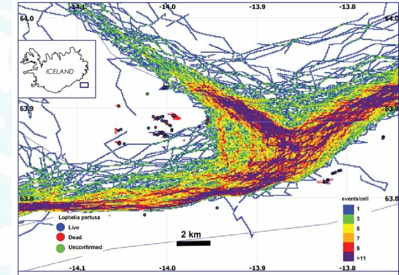
Processing of the positional data from each trawl included the removal of bad GPS fixes and non-fishing records due to Fig. 1. Fishing effort in the Lónsdjúp area. Number of events per cell refers to the 1/2008-6/2010 period. Circles indicate the presence of Lophelia pertusa (blue = live corals, red = dead corals, green = unconfirmed coral report) in
(approximately 150m). Fishing effort, defined as the number of fishing events, was computed for each cell. Although these values are an underestimation of actual fishing effort because of the limited availability of continuous location data, they do provide valuable insight into the spatial patterns of fishing pressure in benthic habitat.
The resulting maps show that even at this spatial scale, fishing effort is highly aggregated, ranging between 1 and 7 fishing events per cell per year. Fishermen target specific geographical areas, bottom depths, and bathymetric features. In the Lónsdjúp area (Fig.1), high fishing effort is observed along the continental shelf break and on the shallower areas north and east of the trough. Observed live coral habitat is located either inside the trough, or on the continental slope. In both locations the bottom topography does not allow bottom trawling.
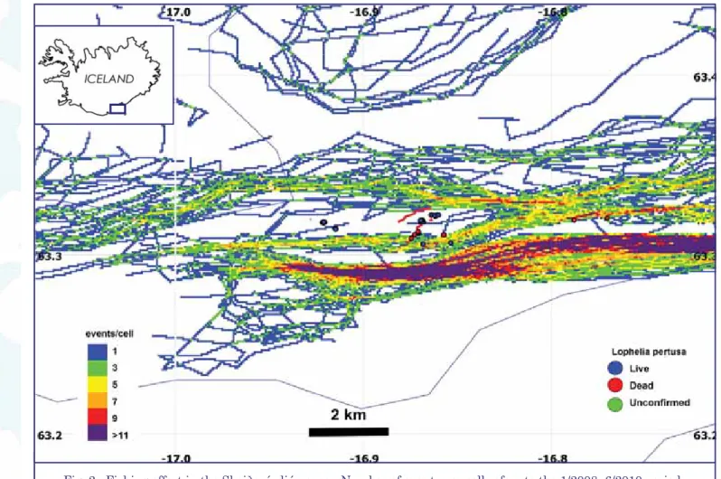
No confirmed live coral habitats have been found in surveys at moderately and intensively fished sites located off southern Iceland, indicating the susceptibility of these habitats to bottom trawling. Currently, pristine coral habitats of any spatial extent are only found in areas that are not targeted by trawlers. Complex bottom features may act as de facto protected areas. In some locations, including the Lónsdjúp and the Skeiðarárdjúp areas (Fig. 1 and 2), cold-water coral habitats were located in close proximity to trawled areas. In the latter area confirmed live coral habitats were located <1km from fished cells trawled up to three times per year. The close proximity between some coral habitat and trawled areas highlights the necessity of mapping significant coral habitats and establish fishing closures with appropriate buffer zones to protect them.
This study demonstrates the importance of high resolution fishing effort data to examine impacts on coral habitats. In Icelandic waters, coral habitats are generally located in areas of complex topography and have a very patchy distribution. At the same time, fishing effort shows a high degree of spatial structure, as trawlers select some areas and avoid others. As a result, impacts assessment based on fishing effort data of low spatial resolution would provide misleading results. High resolution fishing effort data allows a more realistic evaluation of the impact on coral habitats and is an important tool in aiding the identification of the remnant pristine cold-water coral in Icelandic waters.
(Continued from page 2)
Fig. 2. Fishing effort in the Skeiðarárdjúp area. Number of events per cell refers to the 1/2008- 6/2010 period. Circles indicate the presence of Lophelia pertusa (blue = live corals, red = dead corals, green = unconfirmed coral
Long-line surveys of the fish both in and out of coral fields are an important part of the CoralFISH project. Here, Gianfranco D’Onghia and Letizia Sion of CoNISMa, University of Bari, describe the long-line surveys carried out during the 2010 field season in the Northern Ionian Sea.
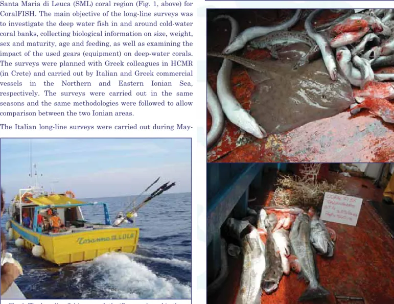
Two long-line experimental surveys were carried out in the Santa Maria di Leuca (SML) coral region (Fig. 1, above) for CoralFISH. The main objective of the long-line surveys was to investigate the deep water fish in and around cold-water coral banks, collecting biological information on size, weight, sex and maturity, age and feeding, as well as examining the impact of the used gears (equipment) on deep-water corals. The surveys were planned with Greek colleagues in HCMR (in Crete) and carried out by Italian and Greek commercial vessels in the Northern and Eastern Ionian Sea, respectively. The surveys were carried out in the same seasons and the same methodologies were followed to allow comparison between the two Ionian areas.
The Italian long-line surveys were carried out during
May-Long-line experimental surveys in the Santa Maria di Leuca coral region
Fig. 2. The long-line fishing vessel, the ‘Rosanna’, used in the long-line surveys in the Santa Maria di Leuca coral region.
June and September-October 2010. IN and OUT coral habitats are about 15 nautical miles off Santa Maria di
(Continued on page 5)
Fig. 1. The location of the Santa Maria di Leuca coral region.
Fig. 3. Long-line configuration. The hooks (size 7 or 9) were baited with 20-40g of Sardina philchardus.
Swivel Long-line rope (2.7-3km long)
Snoods (gangions)
Hook (J-hook)
Leuca Cape. The fishing vessel used in the Northern Ionian Sea was the “Rosanna”, based in the Santa Maria di Leuca harbor (Fig. 2).
Two different long-lines configurations (Fig. 3) were employed using different sizes of J-hook (number 7 and number 9). In general terms the long-lines operated well with good catches. (Fig. 4)
The sampling was carried out over six days. Each day 3 long-lines (2 with J-hook #7 and 1 with J-hook #9) were deployed. The fishing effort was 1500 hooks/day and the set-time lasted an average of 4-5 hours . A total of 18 hauls were carried out: 9 in the coral habitat (IN) and 9 on muddy bottom without corals (OUT), between 400 and 800m water depth.
Catch was recorded in terms of species and number of individuals and where possible, length, weight, sex, and maturity data were collected. The most part of the samples were kept for definitive identification and for further analysis in the laboratory.
A total of 20 benthopelagic species were caught in IN and OUT the SML coral region. The species exclusively captured in the coral habitat were the skates (Dipturus oxyrinchus, Leucoraja circularis and Leucoraja fullonica) and the teleost Pagellus bogaraveo. In both areas the most abundant species were Galeus melastomus, Conger conger, Helicolenus dactylopterus, Merluccius merluccius and Phycis blennoides. Also coral species (Madrepora oculata, Lophelia pertusa, Desmophillum dianthus, Leiophates glaberrima) and sponges were accidentally collected (Figure 5).
(Continued from page 4)
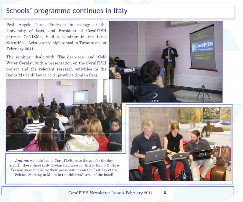
Prof. Angelo Tursi, Professor in ecology at the University of Bari, and President of CoralFISH partner CoNISMa, held a seminar in the Liceo Scientifico “Aristosseno” high school in Taranto on 1st February 2011.
The seminar dealt with “The deep sea" and “Cold Water Corals", with a presentation on the CoralFISH project and the relevant research activities in the Santa Maria di Leuca coral province (Ionian Sea).
Fig. 5. By-catch (i.e. accidental collection) of coral during the long-line survey. Recording such by-catch allows scientists to estimate the impact of such fishing methods on the cold-water
coral communities.
Schools’ programme continues in Italy
And no, we didn’t send CoralFISHers to the zoo for the day (right)…these three (L-R: Stefán Ragnarsson, Kirsty Kemp & Chris
Yesson) were finalising their presentations on the first day of the Science Meeting in Milan in the children’s area of the hotel!
One aspect of CoralFISH looks at ways to model the economic importance (or otherwise) of cold-water corals with respect to commercial fisheries. Here, some of the researchers working in that field summarise their findings when they analysed the Irish orange roughy fishery from an economic perspective. This article is based on a paper in press in the journal Marine Policy by Naomi Foley, Tom van Rensburg, and Claire Armstrong, of the University of Tromso (Norway) and NUIG (Ireland).
There is a growing literature on the effects of subsidies given to deep-water fisheries. A recent paper by CoralFISH researchers discusses the short-lived Irish orange roughy fishery and uses bioeconomic analysis to study the impact of government grant aid for the development of a deep-water fishery.
An Irish commercial fishery for orange roughy began in 2001 with the assistance of government grants. Grant aid was offered to Irish fishermen for the upgrading or purchase of new vessels. The fishery began as an open access, non-quota fishery, with nine suitable vessels involved. During the short period the fishery lasted, harvests peaked in 2002 and then dropped by 75% the following year; fuel prices increased; and price per tonne
dropped by 41% from the peak price. In 2003 a total allowable catch (TAC) of 1,349 tonnes was introduced by the EU for the orange roughy fishery in ICES VII; Ireland received 300 tonnes. All of this resulted in many vessels being forced out of the fishery. The fishery was largely closed in 2005 due to sustainability concerns and the negative effects on cold-water corals.
A bioeconomic model was applied to the available data to assess the open access effort and harvest with and without government grant aid. The results of the bioeconomic analysis are interesting for two reasons. (1) Our calculated open access effort and harvest are
significantly lower than the estimated maximum sustainable yield (MSY) levels, i.e. the costs are so
high that even under open access, the effort is low. (2) Through the analysis it is shown that even in the
presence of grant aid, total costs would have been too high for a sustainable fishery of any size to take place. The analysis with no subsidies suggests that on average the costs were too high, and the prices too low to support any entry into the fishery without generous grants. In essence, the government’s grant aid was a subsidy for mining the Irish orange roughy stock. This can be seen as yet another example of the inefficiencies caused by subsidies and supports the work of others who claim subsidies to be the Achilles heel of deep-sea trawl fleets. There are also additional costs of harvesting orange roughy, namely the potential loss of deep water habitats
such as the loss of cold-water corals (CWC) which can be considered a negative effect of the trawling industry. These so called external effects of deep water trawling include the loss of spawning grounds and existence values associated with CWC habitat.
In conclusion the findings of this paper suggest that deep sea trawling in Ireland for orange roughy contributes very little with respect to net social benefits (profit and/or employment), and has not been economically sustainable. Though mining of orange roughy may be defended on capital theoretic terms, when resource rent is optimally taxed and reinvested, the trawling after orange roughy can be expected to impose significant external effects in terms of losses to the fishery as well as heritage and existence values.
The rise and fall of the Irish orange roughy fishery: an economic analysis
For moreinformation, contact the CoralFISH Project Office
c/o Dr Sadhbh Baxter, Earth & Ocean Sciences, NUI Galway, University Road, Galway, Ireland
T: +353 91 495962; F: +353 91 494533;