Clay-mineral record in Lake Baikal sediments: The Holocene and Late
Glacial transition
Nathalie Fagel , Xavier Boës
Clays and paleoclimate (URAP), Department of Geology, University of Liège, Allée du 6 Août, B18, Sart-Tilman, B-4000 Liège, Belgium Abstract: We analyse the clay-mineralogical composition of two 1-m long cores from elevated plateaus in the southern and northern basins of Lake Baikal. Our aim is to test the limits of classically used clay proxies for climate reconstructions. Mineralogical signature is determined by X-ray diffraction on oriented aggregates from Holocene and Late Glacial sediments. Mineralogical results are presented on a palaeomagnetic-derived time scale. Sampling at a centimeter resolution allows for a sub-millenial order reconstruction. The evolution of clay-derived climate proxies (smectite/illite peak intensity ratio, S/I) is compared between the two locations, with respect to other climate reconstructions for the Lake Baikal area and Siberia. During the Late Glacial punctual increases of S/I are related to changes of particle source rather than any climate change. At both sites the most intense chemical weathering conditions occured during the Subboreal, lagging the Eurasian middle Atlantic climate optimum. S/I follows a gradual but irregular increase through the Holocene, probably related to slow warming favourable to the development of the Siberian soils. The different sensitivity to hydrolysing conditions in northern and southern sites can be explained by a combination of local lithological and topographical parameters.
Keywords: Clay minerals; Climate; Weathering; Late Glacial; Holocene; Lake Baikal
1. Introduction — clays as palaeoclimate proxy: the case study of Lake Baikal
Clay minerals have been widely used as proxies for climate reconstruction in marine and lacustrine environments (e.g., Chamley, 1989). Clays are either primary minerals inherited from parental rocks by physical erosion or secondary minerals produced by chemical weathering. In soils, the type and composition of secondary clay minerals mainly mirror the intensity of hydrolysis prevailing within the catchment. This chemical weathering stage is a combination of climate conditions (temperature, precipitation), topography and tectonic stability (drainage conditions), and parental rocks (Weaver, 1989; Velde, 1995).
In the case of Lake Baikal, only a few studies deal with the Late Quaternary clay record. Most authors (Melles et al., 1995; Yuretich et al., 1999; Horiuchi et al., 2000; Müller et al., 2000; Solotchina et al., 2002, 2004)
evidenced a change in clay-assemblage composition between glacial and interglacial samples. The climate interpretation of clay assemblages is based on the evolution of the smectite/illite ratio (Horiuchi et al., 2000) or of the smectite abundance (Yuretich et al., 1999). S/I and/or smectite abundance is used as a proxy for
hydrolysing conditions around the lake assuming that all smectites result from transformation processes in the soils from the catchment. Weathering conditions are different under warm versus cold conditions: they will influence the relative abundance of the main clay minerals driven to the lake. Warmer conditions favor strong hydrolysis of aluminosilicates in the Baikal catchment, and produce, for instance, random illite-smectite (i.e., smectites s.l.) in soils at the expense of illite (Yuretich et al., 1999). In Baikal sediments, the climate sensitivity of clay minerals was further confirmed by the link between biogenic-rich sediments settled during interglacials and their clay assemblages, i.e., systematically enriched in smectites (Melles et al., 1995; Khasik and Mazilov, 1997; Yuretich et al., 1999; Horiuchi et al., 2000). Besides changes in relative abundance of smectite and illite, other differences in the structures of layered minerals, probably related to weathering process, were observed in Baikal sediments. For instance Solotchina et al. (2002) observed a change from chlorite during glacials to random chlorite-smectite during interglacials. Fagel et al. (2003) rather noticed an opening of illite interlayers and a partial vermiculitization of chlorites in interglacial samples. In the present study of Lake Baikal we test the climate significance of the S/I ratio for the period spanning the transition of the Late Glacial to the Holocene in two clay records from the southern and northern basins of Lake Baikal.
2. Weathering conditions in the catchment of Lake Baikal
According to the global latitudinal pattern of weathering, Lake Baikal is at present located in a zone of moderate chemical weathering characterized by illites and smectites (Allen, 1997). In the catchment of Lake Baikal, illite is a dominant parental mineral located in Proterozoic and Archean granites (Galazy et al., 1993; USGS Central Energy Data Management, 2001). Illite weathering starts with an opening of the clay sheets and loss of
interfoliar K+ by leaching (i.e., degradation process; Chamley 1989; Thorez, 1989). Fig. 1: Location map.
Under regional continental dry climate conditions illite transforms by successive degradation steps (through various intermediate mixed-layer minerals) into smectites or Al-smectites under moderate hydrolysis conditions. Mainly inherited from basic intrusive rocks and metamorphic rocks, chlorite is the second primary mineral in the catchment of Lake Baikal (Galazy et al., 1993; USGS Central Energy Data Management, 2001). Chlorite is easily degraded into chlorite-vermiculite and vermiculite by loss of Mg2+ cations (Thorez, 1989). Recently, Sakai et al. (2005) have analysed the weathering of biotite in a soil of the Selenga River delta. Apparently, the biotite changes into smectite through illite and vermiculite.
In Southern Siberia, three main groups of soils have been defined in Late Quaternary sections: chernozemlike steppe soils, brunisol-like boreal forest soils and regosol-like soils of the periglacial tundra (Chlachula, 2003). Chernozems are characteristic of open steppe and indicative of pronounced continentality; they are the most widely distributed soils in southern Siberia today. Smectite, illite, vermiculite and chlorite are the dominant clay minerals in chernozems around the world (Weaver, 1989). The brunisols represent an intermediate stage of soil development between the initial regosols and the well-developed chernozems, indicative of cooler climates. They are made of micas and interstratified minerals (Weaver, 1989). In the Transbaikalia Mountains within the Selenga catchment, Vogt and Larqué (1998) suggested a possible neoformation of smectites in a weakly developed grey soil profile over syenite. Vogt and Larqué (1998) suggested the formation of small well
crystallized smectites by weathering of chlorite and a possible recombination into a new mineral. The periglacial conditions with freezing soil constitute an ideal confined environment for such a process (Vogt and Larqué, 2002). Indeed smectite has been obtained experimentally from chlorite by repeated freezing and thawing cycles (Koninshchev and Rogov, 1993).
3. Material
3.1. Location and lithology of sediment cores
Within the framework of the EU CONTINENT project, three elevated plateaus characterized by stratified sedimentation were selected for coring after a seismic reconnaissance survey in summer 2001 (Charlet et al., 2005). The mineralogical signature of the clay fraction (<2 µ m) was determined with a 1-cm sampling interval in two pilot cores recovered in the southern and northern basins of Lake Baikal (Fig. 1). Pilot core CON01-604-2a (52.08° N, 105.86° E, 624.5 cm long) was retrieved on the Posolsky Bank in the vicinity of the Selenga Delta, at a water depth of 133 m. Pilot core COM) 1 -603-2a (53.96° N, 108.91° E, 1,127.5 cm long) was drilled in the northern basin of Lake Baikal at a water depth of 386 m, on the northern extension of the Academician Ridge, called "Continent Ridge".
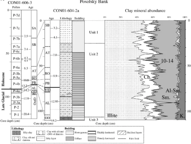
At both sites, the sediments are composed of three lithological units (Fig. 2A,B) identified from macroscopic and smear-slide observations (F. Hauregard, unpublished data; Charlet et al., 2005): clayey sediments with few to rare diatoms (unit 3), clayey silt with diatoms (unit 2), and diatom-rich mud (unit 1).
In core CON01-604-2a (Fig. 2A), unit 3 (105-188 cm) is homogeneous, mainly composed of terrigenous particles. There is a gradual transition to unit 2 (25-105 cm). The sediment is coarsely laminated below 92 cm, then homogeneous to thinly laminated. Three green silty layers are observed between 80 and 84 cm. Unit 1 (0-25 cm) is again homogeneous with a thin 5-mm-thick oxidised layer at the top.
In the pilot core CON01-603-2a (Fig. 2B), the bedding of unit 3 (128-189.5 cm) is homogeneous with some marked silty laminae. Within unit 2 (9.5-128 cm) the indistinct to thin laminae are replaced by thicker laminae below 110 cm, due to the occurrence of centimeter-thick green silty layers. The upper unit (0-9.5 cm) is thinly to thickly laminated. The oxidised layer covers the whole unit 1 (0-11.5 cm). Post depositional sediment reworking is limited in the studied sediment core interval, with only one slump at 130 cm in the Continent Ridge core (Fig. 2B).
3.2. Chronostratigraphy
The age models were derived from magnetic susceptibility and anhysteretic remanent magnetisation measured on the Continent Ridge and Posolsky Bank pilot cores (Demory et al., 2005). Geomagnetic palaeointensities of Lake Baikal sediments were tuned to the ODP 984 reference site (Channell, 1999). The palaeomagnetically-derived age models were constrained by seven correlation points between 9 and 130 cm for CON01-604-2a and by thirteen correlation points between 10.5 and 141.8 cm for CON01-603-2a.
On Posolsky Bank, the sedimentation rate is calculated by linear interpolation between two adjacent correlation points in core CON01-604-2a. It ranges between 6.5 and 9.2 cm/kyr in unit 2, and increases in both the overlying and underlying lithological units (11 cm/kyr in unit 1; 16 cm/kyr in unit 3). The Late Glacial/Holocene (Younger Dryas/Preboreal) transition is fixed at 75/76 cm in the pilot core, in agreement with the sharp decrease in the diatom abundance observed in smear-slides. The 110-cm studied interval covers the last ~14 kyr (Fig. 2A. The Younger Dryas/Preboreal transition derived from either the palynological zonation (Demske et al., 2005) or the 14C age model (Piotrowska et al., 2004) are quite consistent with the geomagnetic age model (Fig. 2A). The age of surface sediments is estimated at 2.4 kyr BP by extrapolation of the youngest sedimentation rate.
On Continent Ridge the sedimentation rate in core CON01 -603-2a averages 10 cm/kyr in unit 2, except for a 20-cm thick interval around 75 cm (3.9 cm/kyr between 66 and 89 cm). Unit 3 starts with the lowest
sedimentation rate for the studied sediment section (3.8 cm/kyr). According to the palaeomagnetically-derived time scale the Late Glacial/Holocene transition occurs at 76 cm (Fig. 2B). This limit encompasses the interval characterized by the pronounced variation in sedimentation rate and by a significant decrease in biogenic silica measured by ICP-OES with a 2.5 cm sampling interval (Oberhaensli, unpublished data) between 70 and 84 cm. Note that the limit fits within a few centimeters with the palynological observation and 14C stratigraphy (Fig. 2B). The 140-cm core section covers the last 22 kyr. No control point was available for unit 1: the age of surface sediments is estimated at 2.8 kyr BP by extrapolation of the youngest sedimentation rate.
According to the mean sedimentation rates, the centimeter-scale sampling step allows for a temporal resolution of the order of 100 years: the average time span between two consecutive samples is ~ 60 to 250 yr.
Fig. 2: Statigraphy, lithology and clay mineralogy of the <2 µm fraction: (A) pilot core CON01-604-2a (southern basin); (B) pilot core CON01-603-2a (northern basin). The chronostratigraphic zonation is from Khotinsky (1984a) based on radiocarbon dates (in ka) converted to calendar ages (in kyr) using a conversion table in Roberts (2002) or Oxcal. The main boundaries are: the Late
Glacial/Holocene or Younger Dryas/Preboreal transition (YD/PB: 10.3 ka=~12.2 kyr BP), the Preboreal/Boreal transition (PB/B: 9.2 ka=~10.3 kyr BP), the Boreal/Atlantic transition (BO/AT: 8 ka= ~ 8 kyr BP), the Atlantic/Subboreal transition (AT/SB: 5 ka = ~ 5.7 kyr BP) and the Subboreal/Subatlantic transition (SB/SA: 2.5 ka= ~ 2.6 kyr BP). On the left: the stratigraphical columns derived from palynological zonation (Demske et al., 2005) and radiocarbon age model (Piotrowska et al., 2004) established for adjacent cores: (A) CON0l-606-3 (southern basin); (B) CON0l-603-5 (northern basin). Note the consistency between the palynological zonation, the radiocarbon and palaeomagnetic (Demory et al., 2005) age models for the Late Glacial/Holocene transition. OstD = Oldest Dryas. Bö=Bölling. OD = Older Dryas. AL=Alleröd.
Fig. 2: (continued).
4. Method
4.1. Sample preparation
Qualitative and semi-quantitative estimations of clay-mineral assemblages are based on peak-intensity
measurements on X-ray patterns running on oriented aggregates (Moore and Reynolds, 1989). A suspension in distilled water of 1 -2 g of dried bulk sediment is sieved at 63 µm and then at 30 µ m. Successive sievings result in a reduction of the amount of diatoms within the clay aggregates. The <2 µ m fraction is taken from the suspension after a settling time calculated according to Stake's law. The suspension is placed on a glass slide and dried overnight at room temperature. Routine X-ray diffraction (XRD) clay analyses included the sequential record of three X-ray patterns under air-dried or natural condition (N), after solvatation with ethylene-glycol for 24 h (EG), and heating to 500 °C for 4 h (H).
4.2. Qualitative identification of clay assemblages
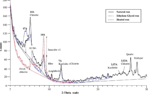
Qualitative identification of the clay species is based on the relative position and intensity of specific reflections between the three X-ray patterns (Fig. 3). Semiquantitative estimation is based on the height of specific
reflections measured in general in the EG runs. Illite content is identified by the peak intensity at 10 Å on EG. The occurrence of kaolinite is deduced from a double peak around 3.5 Å, resulting from the partial overlapping of the (004) chlorite reflection at 3.54 Å and the (002) kaolinite reflection at 3.57 Å under either N or EG
conditions. The chlorite/kaolinite peak intensity ratio measured at 3.54-3.57 Å is then applied to the intensity of the 7 Å (EG) peak to estimate the contribution of kaolinite.
Fig. 3: Interpretation of Lake Baikal X-ray diffraction diagrams derived from the three classical runs, i.e., in natural conditions (N), after ethylene-glycol solvation (EG) and after 500 °C heating (H). The presented X-ray diagram corresponds to one sample collected between 122 and 122.5 cm (122.25 sample depth, 17.5 kyr BP) from the Continent Ridge pilot core (CON01-603-2a). The different identified clay species are semi-quantified from peak-height intensity (I) as follows: illite =
I(10 Ǻ)EGx 1; random 10-14 mixed-layers = 1(12 Ǻ)EGx2.5; Al-smectites = I(17 Ǻ)Nx 5; swelling clays or smectites s.l. = I(10 Å)500-I(10
Å)EGx 1; kaolinite = I(7 Å)EGx [I(3.57 Å)N/[I(3.54 Å)N + I(3.57 Å)N]] × 1.4; chlorites s.l. = I(14 Å)EGx2.5; chlorite fresh ≈ % chlorites × 1(14
Å)H/I(14 Å)EG; weathered chlorites or vermiculites s.l. ≈ 1 - % chlorite fresh. See Method section for explanation.
Swelling clays are evidenced by expansion after EG solvatation but in most of the samples there is no well-defined peak, rather a shoulder of the 14 Å reflection that expands towards the lower angles. This behavior indicates the occurrence of illite within swelling random smectite-illite mixed layers (Thorez, 1976). Therefore the abundance of swelling minerals or smectites s.l. is estimated by the difference between the 10 Å reflection before and after heating as follows: 1(10 Å)H-I(10 Å)EG· According to J. Thorez (pers. comm.), this method "permitted a better estimation of smectite than the measurement of the sole 17 Å (EG) intensity" (in Boski et al., 1998). In addition, the smectite group also comprises a fraction already expanded at 17 Å in the air-dried sample. This behavior is common in many soils, related to Al hydroxides in distended interlayers (Thorez, 2000). The relative contribution of those peculiar smectites, referred here as "Al-smectites", is based on the intensity of the 17 Ǻ reflection on the natural run.
The X-ray behavior of Lake Baikal chlorites is also unusual: the 14 Ǻ reflection is variably and sensitively reduced in intensity after heating at 500 °C. We interpret the sensitivity of chlorites upon heating as indicative of some primary clay degradation. A part of the chlorite (fresh chlorite) has its 14 Ǻ reflection preserved after heating at 500 °C. On the other hand, when chlorite is more or less degraded, its 14 Ǻ peak is replaced by a diffraction band between 10 and 14 Ǻ. Such behavior points to a partial vermiculitization of the chlorite (Thorez, 2000). Further, the height of the residual 14 Ǻ reflection is used to estimate the relative contribution of fresh and degraded chlorite within the complex chlorite group. The relative contribution of all the chlorite (i.e., fresh chlorite and vermiculitized chlorite) called here "chlorites" s.l. is based on the intensity of the 14 Ǻ reflection on the EG run.
Finally, some undifferentiated irregular 10-14 mixed layers were identified by the height of the diffraction band centered on 12 Ǻ on the EG pattern. It was not possible to decipher between random chlorite and/ or illite-vermiculite mixed layers after 500 °C heating due to the partial collapse of degraded chlorites.
4.3. Semi-quantitative estimate of clay assemblages
Taking into account the complex clay assemblage of Lake Baikal, we do not apply any automatic procedure for semi-quantitative estimations. Measurement of peak-surface areas remains tricky due to overlapping between individual clay reflections (Thorez, 1985). We base our quantitative approach on systematic peak-height measurements at the specific reflections listed above. The intensity of the 10 Å peak is taken as a reference, the other intensities are divided by a weight factor (2.5 for 10-14 and chlorites, 1.4 for kaolinite, 5 for Al-smectite) and all identified clay species values are summed up to 100%. Corrective factors were determined by empirical experiments at University of Liège (J. Thorez, pers. comm.). No correction was applied to the smectite reflection since the measurement is made at 10 Å like for illite.
4.4. Definition of smectite/illite ratio
In the clay-derived palaeoclimate approach for Lake Baikal, the smectite/illite peak-intensity ratio (S/I) has been used in Academician Ridge sediments (Fig. 1) as a proxy for chemical weathering in the catchment (Horiuchi et al., 2000). S/I is directly measured on the diffractograms, defined by the peak-height ratio (17 Å)EG/(10 Å)EG. The S/I ratio reflects the abundance of all swelling clays (smectite, random illite-smectite mixed-layers, Al-smectite) versus illite. Assuming that all those swelling clays are secondary minerals formed by transformation process during pedogenesis, this ratio then becomes a proxy for the hydrolysing conditions in the catchment (high S/I ratio during interglacials, low S/ I ratio during glacials).
5. Results: clay-mineral assemblage in pilot cores
The evolution of the clay-mineral assemblages in the Posolsky Bank (CON01-604-2a) and Continent Ridge (CON01-603-2a) pilot cores are plotted by core depth on Fig. 2A and B, respectively (data available upon request). The clay-mineral assemblages of both pilot cores comprise illite, fresh and degraded partly vermiculized chlorites ("chlorites"), random illite-chlorite and/or illite-vermiculite mixed layers ("10-14"), swelling clays made by random illite-smectite with variable amounts of smectite layers (smectite s.l.), "Al-smectite" and kaolinite.
5.1. Clay-mineral assemblage in the southern basin of Lake Baikal, Posolsky Bank (CON01-604-2a)
The Posolsky Bank record is dominated by illite with a mean value of 47%±6 (lσ standard deviation), followed by 27% of smectites. We observe a slightly higher relative amounts of illite (53%) in lithological unit 3 (Fig. 2A) counterbalanced by a decrease in smectites (mean 21%). The mean clay assemblage (Table 1) is close to the representative signature of Selenga River surface sediments, i.e., characterized by a high illite content (54% ±7) associated with 20% of smectites, and 13% of chlorites (data from Fagel et al., 2007). Most of the
clay-assemblage changes are controlled by the opposite evolution between smectites and illite (r2illite-smectites=0·69). A decrease in illite is counterbalanced by an increase in smectites, the changes in the other clay species being minor (Fig. 4A).
The S/I ratio ranges between 0.10 and 1.15 (except 3.4 at the top) with a low mean value of 0.4± 0.4 (lσ) for the studied interval (Table 1 ; Fig. 5). After a relatively high value (~ 7) at the limit Alleröd/Younger Dryas, the 4-point-averaged S/I curve slightly oscillates, shows a minimum during the Boreal and then increases by a factor of two during the Subboreal (Fig. 5).
5.2. Clay-mineral assemblage in the northern basin of Lake Baikal, Continent Ridge (CON01-603-2a)
The Continent Ridge clay record is highly variable: it is composed for 37%±7 of illite, 33%±8 of smectites and 18%± 5 of chlorites on average (Table 1). There is no obvious change between the clay-assemblage composition and the Late Glacial/Holocene transition. Moreover, the variation of smectites does not perfectly mirror the illite evolution (r2illite-smectites = 0·35; Fig. 4B). In contrast to the Posolsky Bank core, the chlorites constitute a third significant clay component, especially in the Holocene (Fig. 4B).
The S/I ratio is more variable and usually higher than in the Posolsky Bank core (Table 1): it ranges between 0.1 and 2.7, with a mean value of 0.8 ±0.5 (lσ). Mean S/I values are relatively low in the Late Glacial interval (Fig. 5). As an exception, the S/I ratio reaches a value of 2.7 in the lower part of the pilot core (at 120 cm, 18.3 kyr BP). After a minimum at the Preboreal/Boreal transition, the 4-point-averaged S/I curve depicts an increasing trend but punctuated by several negative excursions. The maximum S/I ratio is finally reached during the Subboreal at 19 cm (~4.6 kyr BP). The evolution of S/I measured in nearby sediments from the Academician
Ridge (Fig. 1) is plotted for comparison on Fig. 5 (data from Horiuchi et al., 2000). The reported 4-point averaged S/I curve gives a temporal resolution in the order of 600 years on core CON01-603-2a, i.e., close to the sampling resolution of Horiuchi et al.'s data (1 sample ~ 700 yr). Note the parallel trend in the two S/I curves, i.e., a pronounced increase at ca. 18.5 kyr BP, higher Holocene values, maximum values during the Subboreal. Table 1: Mean mineralogical data for Baikal cores and Selenga river sediments
Relative clay mineral abundance
S/I Chlorite group
Core No. of sample I % C % 10-14 % S % S-AL % K % 17EG/10EG Verm. % Fresh chl. % CON01-604-2a Unit 1 26 Mean 45 13 3 29 2 7 0.7 8 6 Standard deviation 6 2 1 5 1 2 0.6 3 1 Min 33 10 1 20 1 4 0.2 3 3 Max 54 17 6 39 5 12 3.4 13 10 Unit 2 78 Mean 47 15 2 27 2 8 0.3 8 7 Standard deviation 6 3 1 6 1 1 0 4 2 Min 29 9 1 0 0 5 0 0 4 Max 66 24 6 40 5 13 1 19 18 Unit 3 6 Mean 53 13 2 21 1 10 0.3 3 11 Standard deviation 5 2 0 7 0 1 0.1 3 3 Min 49 10 1 9 1 9 0.2 0 8 Max 62 16 2 27 2 12 0.5 6 16
Core mean 110 Mean 47 14 2 27 2 8 0.4 8 7
Standard deviation 6 3 1 6 1 2 0.4 4 2 Min 29 9 1 0 0 4 0.1 0 3 Max 66 24 6 40 5 13 3.4 19 18 CON01-603-2a Unit 1 10 Mean 43 13 4 30 3 7 0.5 8 5 Standard deviation 4 2 1 5 2 1 0.1 2 2 Min 36 10 2 22 0 5 0.3 4 3 Max 49 16 6 39 5 9 0.6 12 9 Unit 2 118 Mean 36 18 3 33 3 7 0.9 10 9 Standard deviation 7 3 1 8 1 2 0.4 5 3 Min 25 4 1 1 1 4 0.1 0 3 Max 55 25 7 49 5 13 2.7 21 15 Unit 3 13 Mean 38 15 3 38 2 5 0.6 7 7 Standard deviation 4 4 1 5 0 1 0.1 3 2 Min 28 11 1 32 1 5 0.3 4 4 Max 43 22 4 46 3 8 0.8 14 10
Core mean 141 Mean 37 18 3 33 3 7 0.8 9 8
Standard deviation 7 5 1 8 2 1 0.5 6 3 Min 21 4 1 1 0 4 0.1 0 3 Max 55 36 8 52 9 13 2.7 29 32 Selenga river sediments 22 Mean 54 13 3 20 2 7 0.2 10 3 Min 38 9 1 9 1 5 0.1 4 5 Max 65 18 7 34 5 11 0.4 16 2
Mean mineralogical data for CON01-604-2a pilot core, Posolsky Bank in the southern basin of Lake Baikal; CON01-603-2a pilot core, Continent Ridge in the northern basin of Lake Baikal. Mineralogical data from Selenga River (Fagel et al., 2007). Sediments were collected within the Selenga River catchment (i.e., the modern main tributary to the lake located along the southwestern flank of Lake Baikal) during fieldtrip (EU CONTINENT project) in summer 2001.
Fig. 4: Clay-mineralogical results plotted against the paleomagnetically-derived age model for: (A) pilot core CON01-604-2a (southern basin); (B) pilot core CON01-603-2a (northern basin). An age has been estimated for each sample depth using the age model presented on Fig. 2A and B. respectively. The thicker curves represent the 4-point running average. The dashed line indicates the Late Glacial/Holocene transition. The shaded area underlines peculiar lithological horizons with silty layers.
6. Discussion
6.1. Origin of clay variability through the Late Glacial/ Holocene transition
The clay-mineral record is highly variable (Fig. 2A,B). Such intra-sampling variability partly reflects the accuracy of the XRD method. Even when the sediments have been sieved at 30 µ m, the number of counts on the XRD runs is limited by their diatom-rich matrix. Using the S/I ratio rather than individual relative clay-mineral abundance limits this method artefact. In addition, clay variability could be related to the centennial sampling resolution. This time could be less than the time required for mineral re-equilibrium in soils after climate change and/or than the horizontal mixing of the water masses within the lake. For instance, on Academician Ridge, millennial-order resolution sampling gave a more smoothed clay-mineralogical trend over the same time interval (Horiuchi et al., 2000). To avoid over-interpretation of the data, we will discuss averaged mineralogical curves rather than individual sample data.
Besides the intra-sampling variability, we note a systematic opposite behavior between smectites and illite in the core of the southern basin (CON01-604-2a; Fig. 4A). It could simply reflect a mixing of illite-rich and smectite-rich sources but this source-control hypothesis is not sustained by any lithological changes in the sediments. Even the mineralogical data remain relative, such a trend rather favors a genetic link between those two clays. In accordance with mineral transformation observed in soils of the Selenga River delta (Sakai et al., 2005),
smectites could be formed in the adjacent Selenga catchment by pedogenesis from primary granitoid-derived mica (biotite). Posolsky Bank is under the close control of the Selenga River input and the chemical weathering is mainly controlled by the smectitization processes. In the northern basin (Fig. 4B), the clay assemblages in CON01-603-2a are more complex. The site is located in a more distal position with respect to the main tributary. Besides illite and smectite, other clays, chlorites in particular, influence the mineral assemblage of the lake sediments. At Continent Ridge the weathering pathways include significant vermiculitization-like processes in addition to smectitization.
6.2. Palaeoclimate significance of clay changes
Climate reconstruction is mainly based on vegetation history deduced from pollen analyses. Over Eurasia, the Late Glacial and Holocene records contain several biostratigraphic boundaries that reflect synchronous vegetational and climate change (Khotinsky, 1984a,b). Avalaible Eurasian palynological data have been collected by Velichko et al. (2002) to reconstruct the main features of climate changes since the Late Glacial. The main warm and cold phases have been recognized in palynological (Bezrukova et al., 1996) and pedological (Vorobyova, 1994) studies in the catchment of Lake Baikal but the comparison with Lake Baikal sedimentary records was limited by sampling resolution (Karabanov et al., 2000).
Our goal is to comment on the evolution of clay proxies from Lake Baikal sediments in regard to the state-of-the-art of regional climate reconstructions through the Late Glacial/Holocene transition. On a local scale we will compare our clay results with biological proxies: i.e., the palynological reconstructions established on adjacent box cores in the southern and northern basins (Demske et al., 2005; cfr. Fig. 2A,B), and diatom-derived palaeoproductivity curves from Lake Baikal sedimentary records (e.g., Karabanov et al., 2000; Chebykin et al., 2002; Karabanov et al., 2004). In the following discussion we will focus on the common time interval recorded in both pilot cores, i.e., the last 14 kyr.
6.3.Late Glacial
In Siberia, the Late Glacial is marked by a pronounced continental climate (short and warm summer, long and cold winter, large temperature differences, little precipitation) with a mixed vegetation of forest, tundra and steppe. Pollen data indicate several climate fluctuations with three cold periods, separated by the warm Boiling and Alleröd interstadials (e.g., Khotinsky, 1984b). Within soils the permafrost was more widespread during the Alleröd than at present (Velichko et al., 2002).
In both cores there is no overall obvious and systematic contrast between warm and cold intervals: S/I values remain low (mean ~0.6 in CON01-603-2a;<0.4 in CON01-604-2a) during most of the Late Glacial interval (Fig. 5). As an exception, S/I display peculiar high values (S/I~ 1.8) at ca. 18-19 kyr BP in CON01-603-2a. This change occurs before the inception of warming as recorded in vegetation and fauna (ca. 18 cal. yr BP; Forsström and Greve, 2004) or as suggested by ice-volume simulations (Hubberten et al., 2004). Such S/I increases coincide with punctual 10-%-decreases in illite (Fig. 2B). Going back to the lithological column, this interval coincides with the lower part of unit 2 and it is characterized by repeated silty layers (Fig. 2B). Likewise, in
CON01-604-2a an increase of S/I is also observed in the lower part of lithological unit 2 (Fig. 5). Again it corresponds to a drop in illite content (minus ~ 10% or more) and appears in coarser silty-rich layers (Fig. 2A). Therefore, we emphasize that the punctual increases of S/I occurring in both cores during the Late Glacial cannot be interpreted as an increase in hydrolysing conditions in the catchment of Lake Baikal. Since the youngest mineralogical change (ca. 13 kyr BP at the AL/YD transition) is only recorded in the southern basin, the Late Glacial mineralogical changes probably record a local change in the provenance of the particles supplied to the lake. Previously, Yuretich et al. (1999) also observed unusual high smectite abundance within an older
interglacial (age interval ~ 200-240 kyr BP) in the southern basin (core BDP93, Buguldeika Saddle; Fig. 1). This mineralogical change, synchronous with a major lithological change, was interpreted as the onset of major sediment supplies from the Selenga River. On the Academician Ridge (northern basin; Fig. 1) Horiuchi et al. (2000) also observed a slight increase in the S/I ratio (from 1.1 to 1.5) in Late Glacial sediments ca. 18-18.5 kyr BP (Fig. 5). Again we note this mineralogical change is associated with the highest contribution of silt (>2%) for the last 23 kyr BP. Another lithologically-dependant increase in S/I occurred between 14 and 13 kyr BP (from 1.3 to 2.8) in the Academician Ridge sediments (Horiuchi et al., 2000; Fig. 5).
Fig. 5: Variation with age of smectite/illite ratio (S/I) in core CON01-603-2a (northern basin) and in core CON01-604-2a (southern basin). The dashed line indicates the mean S/I value of the cores. The chronostratigraphical column is from Khotinsky (1984a) with the warm intervals underlined by grey color. The unit refers to the lithological zones defined in the material section (see also Fig. 2A,B). The bold line underlines the Late Glacial/ Holocene transition. S/I data from Horiuchi et al. (2000) have been added for comparison. We present a 4-point running average of our data to get closer to the sampling resolution of the study by Horiuchi et al. (2000).
6.4. Late Glacial/Holocene transition
The transition to the Holocene (i.e., Younger Dryas/ Preboreal) involves a rapid restructuring of landscapes and separates glacial treeless environments from Holocene forest-dominated landscapes (Khotinsky, 1984a). The Younger Dryas is marked by a pronounced cooling and very dry conditions (Velichko et al., 2002). In the northern basin, palynological zone C-3b is marked by an arboreal pollen assemblage without dark taiga species but abundant sub-alpine shrubs: C-3b reflects a cold climate related to the Younger Dryas period (Demske et al., 2005). Similar but less pronounced palynological assemblage changes are also recorded in the southern basin (P4a, Fig. 2A; Demske et al., 2005). The significant cooling during the Younger Dryas is also recorded in West Siberian palynological records (Khotinsky, 1984a; Velichko et al., 2002). In Lake Baikal sediments climatic deterioration during the Younger Dryas depressed planktonic diatoms. For instance, on Buguldeika Saddle in the southern basin (Fig. 1) the diatom population declined almost to full glacial levels and was replaced by
chrysophyte algae (Karabanov et al., 2004). Likewise, Chebykin et al. (2002) evidenced on Posolsky Bank a decrease of nutrient flux which resulted in a decline in diatom abundance during the Younger Dryas. The Late Glacial/Holocene transition is not underlined by any sharp changes in the relative clay-mineral abundance (Fig. 3A,B). In the Posolsky Bank pilot core, the S/I ratio increases after the Younger Dryas/ Preboreal transition (Fig. 5). In the Continent Ridge pilot core, the S/I ratio displays the lowest values from the Alleröd until the end of the Preboreal. The YD climate event, although severe, appears to be too short to influence the clay-mineral record in lacustrine sediments; the time is probably insufficient to reach a new equilibrium in soils producing different secondary minerals.
6.5. Holocene interval
The mean temperature and precipitation were close to the present-day values during the Preboreal (Velichko et al., 2002), but the lake is characterized by a north-south gradient: the southern part is colder and drier than the northern part (Velichko et al., 2002; Demske et al., 2005). The Boreal is characterized by the disappearance of Late Glacial vegetation. Simulations suggest that after 10 kyr the Eurasian ice sheets had melted (Forsström and Greve, 2004). The period ended with a brief cooling marked in Siberia by a degradation of the taiga. The Atlantic period is characterized by an expansion of forest with a marked optimum in its upper part (Khotinsky, 1984a). The Atlantic/Subboreal transition encompasses a cooling stage followed by a complex Subboreal period. In Siberia, the Subboreal and Subatlantic periods correspond to a unique stage of vegetational development, marked by increased aridity and continentality in Western Siberia (Khotinsky, 1984a,b).
At both sites, S/I values increase by a factor of four through the Holocene reaching their maxima in the Subboreal (Fig. 5). The highest S/I values are also measured during the same period in the Academician Ridge sediments (data from Horiuchi et al., 2000; Fig. 5). The mineralogical change lags by ~ 2 kyr the optimal climatic period (i.e., Atlantic), identified locally in soils from the Lake Baikal area (Vorobyova, 1994), but also regionally in palaeoenvironmental indicators in North (Schirrmeister et al., 2002) and West Siberia (Khotinsky, 1984a). Moreover, the clay-mineral curve also lags the main palynological change recorded in the lacustrine sediments (Fig. 5). Defined by a drop in arboreal and non-arboreal steppe vegetation counterbalanced by an extension of light taiga pollen taxa, the transitions P-5b/P-6a in the southern basin (Fig. 2A) and C-5b/C-6a in the northern basin (Fig. 2B) correspond to the sharpest and highest temperature increase for the whole pollen sequences (Demske et al., 2005).
A slow and irregular increase in diatom abundance was observed in Lake Baikal sediments since the Late Glacial/Holocene transition (Karabanov et al., 2000; Chebykin et al., 2002). The highest diatom content was observed locally during the Subboreal period (Karabanov et al., 2000). The high-frequency fluctuations in the diatom curve indicate instability in diatom production, related to climate instability according to Karabanov et al. (2000). Chebykin et al. (2002) suggested that the irregular rate of diatom production was rather controlled by the slow process of formation of new soils and weathering of rocks in the catchment. The slow diatom recovery may be a consequence of the gradual weathering of Holocene soils. The gradual increase in the S/I ratio since the Late Glacial/Holocene transition, especially marked in the Continent Ridge pilot core, is more consistent with this hypothesis. Even though a climate deterioration is evidenced since the early Subboreal in Siberia, the
Atlantic/Subboreal transition corresponds to a major change in soil conditions from cold and humid to warm and humid (Schirrmeister et al., 2002). In late Quaternary profiles surrounding Lake Baikal, geochemistry and soil development indicate two warm and humid intervals within the Subboreal (Vorobyova, 1994) that are not recorded in the general reconstruction of Khotinsky (1989). Both conditions favor active pedogenesis leading to the observed high chemical-weathering indexes, especially in the northern site.
6.6. Comparison of clay proxy records in the northern and southern basins of Lake Baikal
Clay-mineral ratios follow parallel evolutions at the two studied locations, in the southern and northern basins of Lake Baikal. However, S/I values are systematically lower at Posolsky Bank than at Continent Ridge or on Academician Ridge (Fig. 5). This suggests a lower sensitivity of the catchment environment close to Posolsky Bank than at Continent Ridge. It could result from a combination of several local parameters in the southern and northern basin catchments, respectively. The vicinity of the Selenga River, the present main tributary, is probably important. Like at Buguldeika Saddle (Yuretich et al., 1999; Fig. 1), sediment delivery at Posolsky Bank is under the direct control of one single river (the Selenga River) that homogenizes the erosion products from the catchment. A more complex mixing of sources is probable in the northern basin. Moreover, the two sites lie close to highly differentiated relief areas: Continent Ridge is close to the Barguzin mountain range, whereas Posolsky Bank is part of the low-altitude Selenga River delta. As topography is a key factor in the drainage conditions, it also influences secondary mineral formation: hydrolysis conditions could be less intense in the southern Lake Baikal catchment than in the north due to limited runoff.
7. Conclusion
We test the application of sedimentary clay minerals as abiotic climate proxies in two cores from the northern and southern basins of Lake Baikal. Assuming that all clays are detrital, the evolution of clay assemblages contain a fingerprint of the weathering conditions within the catchment, further related to the climate regime. For Lake Baikal sediments we conclude that the S/I ratio is usually an indirect climate-relevant proxy but lithological information is essential to avoid any change of source affecting the composition of the mineral assemblages. Moreover, the S/I ratio is especially sensitive to soil conditions. Its evolution lags the Siberian Atlantic climate optimum, as recorded in sedimentary palynological assemblages. This lag probably takes into account the response time for soil re-equilibrium. Besides a noisy intra-sampling variability, the submillenial clay-mineral evolution in both the southern and northern basins is consistent with other records from Academician Ridge. Finally, site location controls the sensitivity of the clay records due to local parameters.
Acknowledgements
The study was performed as part of the EU project EVK2-CT-2000-00057 "CONTINENT: high-resolution continental palaeoclimate record in Lake Baikal: a key-site for Eurasia teleconnections to the North Atlantic Ocean and monsoonal system". The authors wish to thank Dr. Hedi Oberhaensli (GFZ, Potsdam), coordinator of the EU project, Lena Vologina (LIN, Irkutsk), Dieter Demske (FU, Berlin), Virginie Renson (ULg, Belgium) and François Demory (GFZ, Potsdam) for discussions and/or technical support. The authors also thank H. Chamley and E. Goldberg for their hepful reviews, and D. Bain for his constructive suggestions on an earlier version of this manuscript.
References
Allen, P.A., 1997. Earth surface processes. Blackwell. 404 pp.
Bezrukova, E.V., Mats, V.D., Letunova, P.P., Nakamura, T., Fuji, S., 1996. Holocene peat bogs in Prebaikalia as an object of paleoclimatic reconstructions. Russian Geology and Geophysics 37, 78-92.
Boski, T., Pessoa, J., Pedro, P., Thorez, J., Dias, J.M.A., Hall, I.R., 1998. Factors governing abundance of hydrolysable amino acids in the sediments from the NW European Continental margin (47-50°N). Progress in Oceanography 42, 145-164.
Chamley, H., 1989. Clay Sedimentology. Springer-Verlag, Berlin. 623 pp.
Channell, J.E.T., 1999. Geomagnetic intensity and directional secular variation at Ocean Drilling Program (ODP) site 984 (Bjorn Drift) since 500 ka: comparison with ODP983 (Gardar Drift). Journal of Geophysical Research B 104, 22937-22951.
Charlet, F., Fagel, N., De Batist, M., Hauregard, F., Minnebo, B., Meischner, D., the SONIC Team, 2005. Sedimentary dynamics on isolated highs in Lake Baikal: evidence from detailed high-resolution geophysical data and sediment cores. Global and Planetary Change 46, 125-144.
Chebykin, E.P, Edgington, D.N., Grachev, M.A., Zheleznyakova, T.O., Vorobyova, S.S., Kulikova, N.S., Azarova, I.N., Khlystov, O.M., Goldberg, E.L., 2002. Abrupt increase in precipitation and weathering of soils in East Siberia coincident with the end of the last glaciation (15 cal kyr BP). Earth and Planetary Science Letters 200, 167-175.
Chlachula, J., 2003. The Siberian loess record and its significance for reconstruction of Pleistocene climate change in north-central Asia. Quaternary Science Reviews 22, 1879-1906.
Demory, F., Nowaczyk, N.R., Witt, A., Oberhänsli, H., 2005. High-resolution magnetostratigraphy of late Quaternary sediments from Lake Baikal, Siberia: timing of intracontinental paleoclimatic responses. Global and Planetary Change 46, 145-166.
Demske, D., Heumann, G, Granoszewski, W., Nita, M., Mamakowa, K., Tarasov, P.E., Oberhänsli, H., 2005. Late Glacial and Holocene vegetation and regional climate variability evidenced in high-resolution pollen records from Lake Baikal. Global and Planetary Change 46, 255-279.
Fagel, N., Boski, T., Likhoshway, L., Oberhaensli, H., 2003. Late Quaternary clay mineral record in Central Lake Baikal (Academician Ridge, Siberia). Palaeogeography, Palaeoclimatology, Palaeoecology 193, 159-179.
Fagel, N., Thamó-Bózsó, E., Heim, B., 2007. Mineralogical signatures of Lake Baikal sediments: sources of sediment supplies through Late Quaternary. Sedimentary Geology 194, 37-59.
Forsström, PL., Greve, R., 2004. Simulation of the Eurasian icesheet dynamics durring the last glaciation. Global and Planetary Change 42, 59-81.
Galazy, G.I. (Ed.), 1993. Baikal Atlas. Federal Agency for Geodesy and Cartography, Moscow. 160 pp. [in Russian].
Horiuchi, K., Minoura, K., Hoshino, K., Oda, T., Nakamura, T., Kawai, T., 2000. Paleoenvironmental history of Lake Baikal during the last 23000 years. Palaeogeography, Palaeoclimatology, Palaeoecology 157, 95-108.
Hubberten, H.W., Andreev, A., Astakhov, V.I., Demidov, I., Dowdeswell, J.A., Henriksen, M., Hjort, C, Houmark-Nielsen, M., Jakobsson, M., Kuzmina, S., Larsen, E., Lunkka, J.P, Lyså, A., Mangerud, J., Möller, P., Saarnisto, M., Schirrmeister, L., Sher, A.V., Siegert, C, Siegert, M.J., Svendsen, J.I., 2004. The periglacial climate and environment in northern Eurasia during the Last Glaciation. Quaternary Science Reviews 23, 1333-1357.
Karabanov, E.B., Propopenko, A.A., Williams, D.F., Khursevich, G.K., 2000. A new record of Holocene climate change from the bottom sediments of Lake Baikal. Palaeogeography, Palaeoclimatology, Palaeoecology 156, 211-224.
Karabanov, E., Williams, D., Kuzmin, M., Sideleva, V., Khursevich, G, Prokopenko, A., Solotchina, E., Tkachenko, L., Fedenya, S., Kerber, E., Gvozdkov, A., Khlustov, 0., Bezrukova, E., Letunova, P., Krapivina, S., 2004. Ecological collapse of Lake Baikal and Lake Hovsgol ecosystems during the Last Glacial and consequences for aquatic species diversity. Palaeogeography, Palaeoclimatology, Palaeoecology 209, 227-243.
Khasik, S.A., Mazilov, V.N., 1997. Lithology of Quaternary deposits in deep borehole section from Lake Baikal. Lithology and Mineral Deposits 5, 484-491 [in Russian].
Khotinsky, N.A., 1984a. Holocene vegetation history. In: Velichko, A.A. (Ed.), Late Quaternary Environments of Soviet Union. University of Minnesota Press, Mineapolis, pp. 179-200.
Khotinsky, N.A., 1984b. Holocene climate change. In: Velichko, A.A. (Ed.), Late Quaternary Environments of Soviet Union. University of Minnesota Press, Mineapolis, pp. 305-309.
Khotinsky, N.A., 1989. Discussion of problems of Holocene correlation and paleoreconstructions. In: Khotinsky, N.A. (Ed.), Paleoclimates of the last Glacial and the Holocene. Nauka, Moscow, pp. 12-14. [in Russian].
Koninshchev, V.N., Rogov, V.V., 1993. Investigations of cryogenic weathering in Europe and northern Asia. Permafrost and Periglacial Processes 4, 49-64.
Melles, M., Grobe, H., Hubberten, H.W., 1995. Mineral Composition of the Clay Fraction in the 100 m Core BDP-93-2 from Lake Baikal — preliminary results. In: Horie, S. (Ed.), IPPCC Newsletter 9. Universitätsverlag Wagner, Innsbruck, pp. 17-22.
Moore, D.M., Reynolds Jr., R.C., 1989. X-Ray Diffraction and the Identification and Analysis of Clay Minerals. Oxford Univ. Press, Oxford, New York. 378 pp.
Müller, J., Kasbohm, J., Oberhänsli, H., Melles, M., Hubberten, H.-W., 2000. TEM Analysis of Smectite-Illite Mixed-layer Minerals of BDP-96-1 — preliminary results. In: Minoura, K. (Ed.), Lake Baikal: A Mirror in Time and Space for Understanding Global Change Processes. Elsevier, Amsterdam, pp. 90-100.
Piotrowska, N., Bluszcz, A., Demske, D., Granoszewski, W., Heumann, G, 2004. Extraction and AMS radiocarbon dating of pollen from Lake Baikal sediments. Radiocarbon 46, 181-187.
Roberts, N, 2002. The Holocene. An environmental history. Black-well Publishing, Oxford. 316 pp.
Sakai, T., Minoura, K, Soma, M., Tani, Y., Tanaka, A., Nara, F., Itoh, N., Kawai, T., 2005. Influence of climate fluctuation on clay formation in the Baikal drainage basin. Journal of Paleolimnology 33, 105-121.
Schirrmeister, L., Siegert, C, Kuznetsova, T., Kuzmina, S., Andreev, A., Kienast, F., Meyer, H., Bobrov, A., 2002. Paleoenvironmental and paleoclimatic records from permafrost deposits in the Arctic region of Northern Siberia. Quaternary International 89, 97-118.
Solotchina, E.P, Prokopenko, A.A., Vasilevsky, N., Gavshin, V.M., Kuzmin, M.I., Williams, D.F., 2002. Simulation of XRD patterns as an optimal technique for studying glacial and interglacial clay mineral associations in bottom sediments of Lake Baikal. Clay Minerals 37, 105-119.
Solotchina, E.P, Kuzmin, M.I., Prokopenko, A.A., Stolpovskaya, V.N., Solotchin, P.A., Shul'zhenko, S.G, 2004. Clay minerals and Paleoclimatic signals in the Holocene-Pleistocene sediments of Lake Baikal. Doklady Earth Science 398, 1006-1011.
Thorez, J., 1976. In: Lelotte, G (Ed.), Practical Identification of Clay Minerals. Dison, Belgium.
Thorez, J., 1985. Argillogenesis and the hydrolysis index. Miner-alogica et Petrographica Acta 29, 313-338.
Thorez, J., 1989. Argilloscopy of weathering and sedimentation. Bulletin de la Société Géologique de Belgique 98, 245-267.
Thorez, J., 2000. Cation-saturated swelling physils: an XRD revisitation. Proceedings of the 1st Latin-American Clay Conference, Funchal, Madeira vol. I, 71-85.
USGS Central Energy Data Management, 2001. World Energy Resources, http://energy.cr.usgs.gov/oilgas/wep/products/geology. htm (Date accessed: [24.01.2003]).
Velde, B., 1995. Origin and mineralogy of clays. Clays and the environment. Springer-Verlag, Berlin. 356 pp.
Velichko, A.A., Catto, N, Drenova, A.N., Klimanov, V.A., Kreme-netski, K.V., Nechaev, V.P, 2002. Climate changes in East Europe and Siberia at the Late Glacial-Holocene transition. Quaternary International 91, 75-99.
Vogt, T., Larqué, P., 1998. Transformations and neoformations of clay in the cryogenic environment: examples from Transbaikalia (Siberia) and Patagonia (Argentina). European Journal of Soil Science 49, 367-376.
Vogt, T., Larqué, P., 2002. Clays and secondary minerals as permafrost indicators: examples from the circum-Baikal region. Quaternary International 95-96, 175-187.
Vorobyova, G.A., 1994. Paleoclimates around Lake Baikal in Pleistocene and the Holocene. Baikal as a natural laboratory for global change, vol. 2. Lisna Publi, Irkutsk, pp. 54-55.
Weaver, C.E., 1989. Clay, muds, and shale. Developments in Sedimentology, vol. 44. Elsevier, Amsterdam. 819 pp.
Yuretich, R., Melles, M., Sarata, B., Grobe, H., 1999. Clay minerals in the sediments of Lake Baikal: a useful climate proxy. Journal of Sedimentary Research 69, 588-596.