Submitted to the 1
stInternational Conference on Energy, Environment And Climate Changes
Analysis of the past (1970-1999) and future (2046-2065 and 2081-2100) evolutions of
precipitation and temperature, in the Province of Binh Thuan, South East Vietnam,
based on IPCC models
Sébastien DOUTRELOUP, Michel ERPICUM, Xavier FETTWEIS Department of Geography, Laboratory of Climatology, University of Liège
Allée du 6 Août, 2, B-4000 Liège, Belgium
e-mail: [email protected], [email protected], [email protected]
Pierre OZER
Department of Environmental Sciences and Management, University of Liège Avenue de Longwy 185, B-6700 Arlon, Belgium
e-mail: [email protected]
Abstract— Natural resource-dependent societies in developing countries are facing increased pressures linked to global climate change. The Province of Binh Thuan, in South East Vietnam, where rainfall is on average 500 to 700 mm but can drop as low as 350 mm in some years, knows a recent increase of agricultural activities in order to contribute to reduce poverty although the technical efficiency of Binh Thuan is still very low. Within this framework of higher dependency of the local economy on the agricultural sector, there is growing evidence that changes in climate extremes are increasing exposure of currently vulnerable rural populations.
In order to assess the future climate of the province of Binh Thuan, only three models able to simulate the current climate in the study area were used out of the 24 selected by the IPCC: CCCMA-T47, INGV and IPSL.
The future climate projections (that is 2046-2065 and 2081-2100 compared to historical data 1970-1999) were focused on two targets: [i] assessing changes in climate statistics, and [ii] analysing the beginning and the end of the rainy season.
[i] The first analysis indicates an increase of mean temperature of about 1.6°C (over 2046-2065) and 2.5°C (over 2081-2100) and an increase of extreme temperatures and extreme rainfall events. However, no significant changes about the evolution of the annual amount of precipitation were found.
[ii] The second analysis indicates that the dry season is likely to be longer in 2046-2065 owing to a delay in the onset of the rainy season (up to 15 days) accompanied by an earlier end of the rainy season (up to 30 days).
Although it must be kept in mind that precipitations are the most difficult climate variable to predict, it is likely that increasing water needs to support expending agriculture within the context of climate change in the Province of Binh Thuan will be a challenge. Indeed, extreme rainfall events are likely to increase and unchanged yearly amounts of precipitation should be concentrated in time.
Keywords: climate change, precipitation, temperature, climate extremes, Binh Thuan, Vietnam
I. INTRODUCTION
Extreme weather and climate events have received increased attention in the last few years in the context of global climate change. Yet, the latest Intergovernmental
Panel on Climate Change (IPCC) report predicts, by the mid- to late 21st century, a virtually certain (that is a probability of occurrence of over 99%) augmentation in warmer nights and hot days, and a very likely (that is a probability of occurrence of over 90%) increase in warm spells, heat waves and heavy precipitation [1]. Without taking into account any changes or developments in adaptive capacity, the major projected impacts of these changes in warm regions are:
• Agriculture, forestry and ecosystems: reduced yields in warmer regions due to heat stress; damage to crops and soil erosion consequently to heavy precipitations; inability to cultivate land due to waterlogging of soils;
• Water resources: increased water demand consequently to warming; adverse effects on quality of surface and groundwater; contamination of water supply;
• Human health: increased risk of heat-related mortality (especially for the elderly, chronically sick, very young and socially isolated); increased risk of deaths, injuries and infectious and skin diseases due to heavy precipitations and consecutive flooding; • Industry, settlement and society: increased energy
demand for cooling; reduction in quality of life for people in warm areas without appropriate housing; disruption of settlements, commerce, transport and societies due to flooding: pressures on urban and rural infrastructures; loss of property [1].
Vietnam‘s exposure to weather-related events and disasters ranks among the highest among all developing countries [2-3]. Storms and floods (occasionally resulting from tropical cyclones) have caused extensive and repeated damages to buildings and infrastructure, significant losses to the agriculture and fisheries sectors, and resulted in a large number of fatalities. In the course of the 20th century, approximately 25,000 lives have been lost in Vietnam as a direct result of climate related events. Between 1991 and 2000 more than 8,000 people were killed by natural disasters (storms, floods, flash floods, landslides). In addition, an estimated 6 million houses were destroyed. The total economic value of losses for this period alone was estimated at USD 2.8 billion [4]. This is the reason why water
resources management has become a major concern at the national scale.
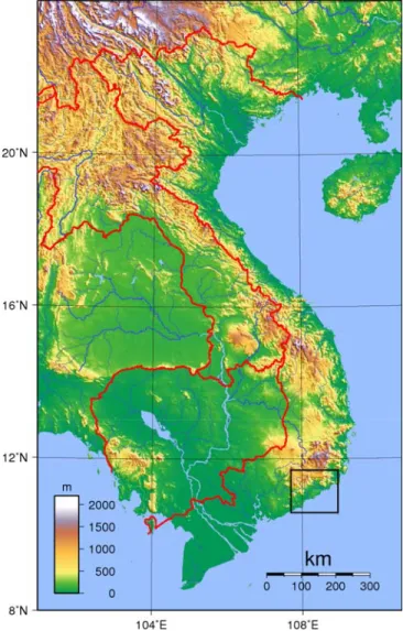
The Province of Binh Thuan, in South East Vietnam (Fig. 1), where rainfall is on average 500 to 700 mm but can drop as low as 350 mm in some years [5], is characterised by a monsoon [6].
Figure 1. Vietnam topography with the region of interest in the black rectangle (source: http://fr.wikipedia.org/wiki/Viêt_Nam).
There are two distinct periods; a dry period and a wet period. The dry period begins approximately in November through April and the wet period from May through October. The wet season is characterised by two maximum of precipitations. The first one is in May-June and the second one is in September-October. These maximum of precipitations are due to the round-trip of the monsoon. The first maximum occurs when the Inter-Tropical Convergence Zone (ITCZ) goes to the North. During this passage, the air masses are saturated in humidity thanks to all Indonesian water mass. And the second maximum occurs when the ITCZ goes to the South. During this passage, the air mass is also saturated in humidity thanks to the South China Sea. The evolution of temperature is relatively constant through
the year. The monthly mean temperatures oscillate between 25°C and 30°C.
The Province knows a recent increase of agricultural activities in order to contribute to reduce poverty although the technical efficiency of Binh Thuan is still very low [7-9]. Within this framework of higher dependency of the local economy on the agricultural sector, there is growing evidence that changes in climate extremes are increasing exposure of currently vulnerable rural populations.
This present study is realized within the framework of the project entitled “Impact of global climate change and desertification on the environment and society in Southern Central Vietnam - Case study in Binh Thuan Province” and aims to assess the future climate of the province of Binh Thuan.
II. DATA
In this section, we present all the data used in this work and briefly explain how they were created, where we can find them, and what are their advantages and disadvantages. A. ECMWF and NCEP-NCAR Reanalysis
The reanalysis models in general are global models which calculate the past climate with a forcing of the meteorological observations including radiosondes, balloons, aircraft, buoyes, satellites, scatterometers. We can consider the reanalysis as the best representations of the past climates. In this study, we used the 30-year period extending from January 1970 through December 1999.
The ECMWF reanalysis [10] is one of the reanalysis model used in climatology over the period from September 1957 through August 2002 while the NCEP-NCAR Reanalysis-1 [11] is another reanalysis model used in climatology over the period from January 1948 through present.
The advantage of using such datasets is that the entire world is covered by at least one set of meteorological data. The disadvantage is that data over one region are interpolated compared with the real observation data in a meteorological station. The interpolation is proportional to the spatial resolution of the model (see Table 1). A second advantage can be found in the nature of these data. Yet, those are calculated by a model. This fact implies that we compare two models among them and not local observations with a global model. The local observations represent the climate of one site and are very difficult to apply to an entire region because the site of measurements has specific characteristics that may not be similar to an entire surrounding area.
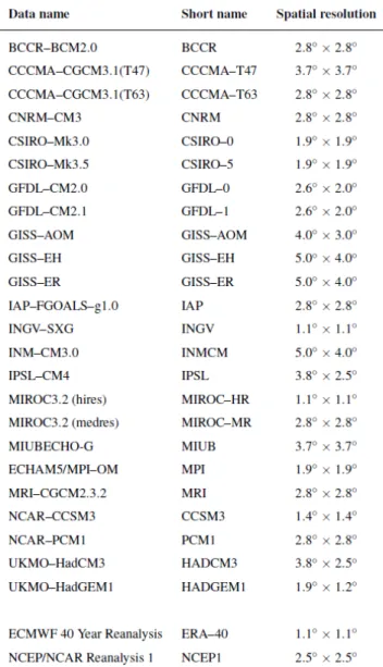
B. Models selected by the IPCC
The IPCC [12] has selected 24 models in its last report (Table 1). These models are forced by none observational data. All of these models have initial conditions, which are created randomly and the models run from these initial conditions until they reach equilibrium conditions. According to their internal configurations, the models are different. Thus, some models may not be consistent with the real climate.
All models have a different spatial resolution (Table I). Some models have a relatively precise spatial resolution like the INGV model with 1.1° latitude and 1.1° longitude whereas other models have a coarse spatial resolution like the GISS–EH model with 5.0° latitude and 4.0° longitude. This fact implies that the interpolation of data over one region is bigger when the spatial resolution is coarse.
TABLE I. MODELS AND REANALYSES USED IN THIS STUDY WITH THEIR SHORT NAME AND SPATIAL RESOLUTION.THE AOGCMS SHORT
NAMES ARE BASED ON THE WORK OF LELOUP ET AL.[13].†
† Data source: the World Climate Research Programme’s (WCRP’s) Coupled Model Intercomparison Project phase 3 (CMIP3). The IPCC models have different time periods. Firstly, the IPCC models have a scenario called 20C3M which calculates past climate over the 1961-2000 period. As mentioned above, we used this scenario over the 1970-1999 period in the two sorting to compare with the reanalysis models.
Secondly, the IPCC models forecast different time periods in the future using different scenarios. In this work, we used the 20-year periods 2046-2065 and 2081-2100 for three different scenarios: B1, A1B, A2 [12]. So we eliminated two intermediate scenarios (B1 and A1T) as well as the worst case scenario (A1FI) [1] although recent trends in global GHG emissions show that the latter scenario is far from being unlikely [14].
• The B1 scenario believes that the world will be more integrated and more ecologically friendly. It is characterized by: a rapid economic growth but with rapid changes towards a service and information economy; a population rising to 9 billion in 2050 and then declining; reductions in material intensity and the introduction of clean and resource efficient technologies; and an emphasis on global solutions to economic, social and environmental stability. With this scenario which is the most optimistic about the future behaviour of our societies and presumably the less probable given the weak global policy response to climate change [15], best global temperature change estimate between 1980-1999 and 2090-2099 is +1.8°C, with a likely range of +1.1°C to 2.9°C. • The A1B scenario bets on a more integrated world
and is characterized by: a rapid economic growth; a global population that reaches 9 billion in 2050 and then gradually declines; the quick spread of new and efficient technologies; a convergent world income and way of life converge between regions; extensive social and cultural interactions worldwide; and a balanced emphasis on all energy sources. With this scenario, best global temperature change estimate between 1980-1999 and 2090-2099 is +2.8°C, with a likely range of +1.7°C to 4.4°C.
• The A2 scenario imagines a more divided world. It is characterized by: a world of independently operating, self-reliant nations, a continuously increasing population, a regionally oriented economic development, a slower and more fragmented technological changes and improvements to per capita income. With this scenario, best global temperature change estimate between 1980-1999 and 2090-2099 is +3.4°C, with a likely range of +2.0°C to 5.4°C.
III. METHODOLOGY
In order to predict future temperatures and precipitations in South-Eastern Vietnam during the 21st century, future projections models selected by the IPCC were used. The first step was to test the ability of each model to simulate the past climate (1970-1999) in South-Eastern Vietnam in order to select the best models. The second step was to use the future projections of these selected models to obtain future trends of temperatures and precipitations.
Tests were performed on the 24 different models available. From the beginning, we rejected the BCCR, INMCM, HADCM3 and HADGEM1 models because all required data for this study were not available. All models
are not suitable to analyse the future projections. So, the first step was to sort them and select the models which best simulate past climate in the Province of Binh Thuan. For this aim, we compared the IPCC models with the ECMWF and NCEP-NCAR reanalysis. We sorted the models two successive steps. The first sorting was performed to eliminate the worst models and the second sorting was done to keep the best models and obtain some models from which we used the projections of future climatic parameters and their evolutions.
For the first sorting, we used daily data of the IPCC models, the ECMWF and NCEP-NCAR reanalysis during the 1970-1999 period. For each IPCC models, we calculated the monthly mean temperature at 2 meter-height and the monthly sum of precipitations. We also calculated the monthly standard error (σ) of temperatures and precipitations for the reanalysis models. Then we plotted the IPCC models data on a climograph with superimposed ±2σ results of each reanalysis model.
The method to eliminate the less appropriated IPCC models for the region of interest was based on 2 criteria:
• The curves of temperatures and precipitations had to respect the best the behaviour of the curves of the reanalysis models. Especially, the curves of temperatures and precipitations had to respect at best the dry and wet seasons;
• The curves of temperatures and precipitations had to be included at best into the range of ±2σ. The aim of this sorting consisted in selecting the models for which the curve was included (or very near) into the range determined by the ±2σ limits of the reanalysis. Thus we kept only the models which best represented reality given by the reanalysis.
After these two sortings, we considered that all selected models best represented reality given by the reanalysis models and thus were the models which best represented future projections.
The future climate projections (that is 2046-2065 and 2081-2100 compared to historical data 1970-1999) were focused on two targets:
• Assessing changes in climate statistics (annual mean temperature, annual amount of precipitation, standard deviation of temperature and precipitation, maximum and minimum of temperature and precipitation);
• Analysing the beginning and the end of the rainy season.
IV. RESULTS
A. Selection of the IPCC models
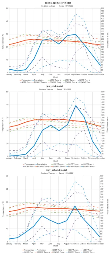
All criteria mentioned above were applied to the IPCC models. All detailed climographs can be retrieved from Doutreloup et al. [16]. Although they may seem quite different, three models were selected: CCCMA-T47, IPSL and INGV (Fig. 2).
Figure 2. Climographs of the 3 selected IPCC models with the reanalysis models error curve of ±2σ. The continuous blue and red curves represent monthly precipitations and temperatures of the models. The discontinuous
blue and violet curves represent the ±2σ monthly precipitations in the ECMWF and the NCEP-NCAR reanalysis models. The discontinuous red and green curves represent the ±2σ monthly temperatures in the ECMWF
B. Changes in climate statistics
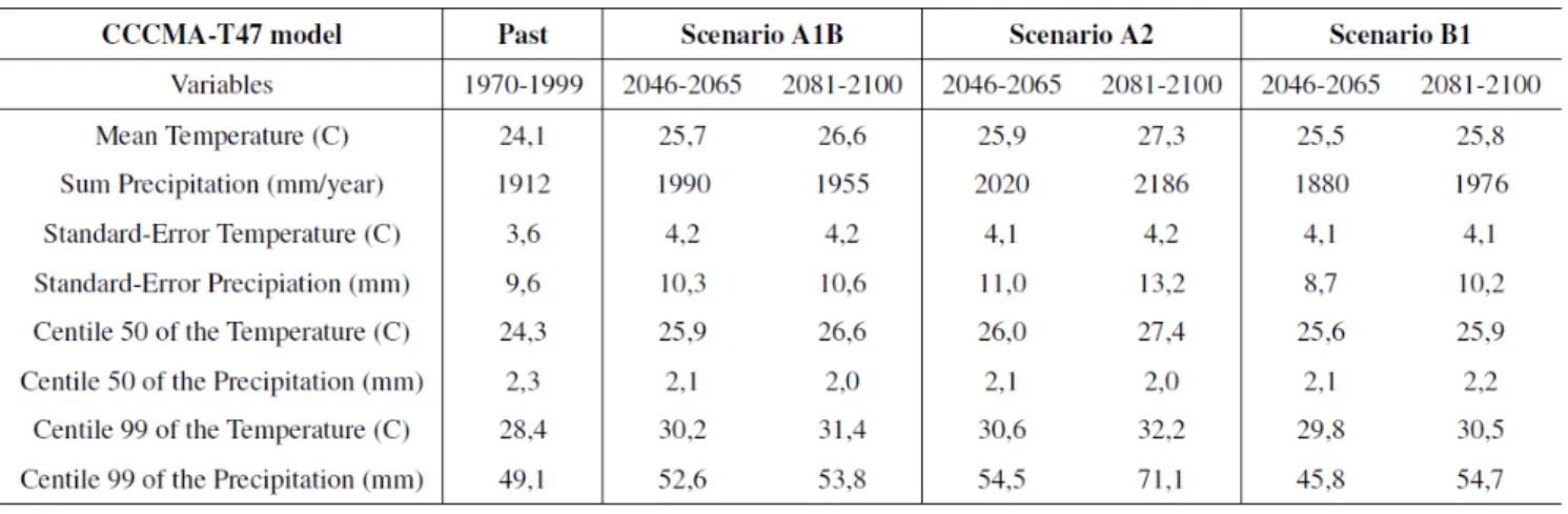
Future projected changes in climate statistics for periods 2046-2065 and 2081-2100 compared to past records (1970-1999) were performed for the three selected IPCC models using scenarios A1B, A2 and B1. Results are given in Tables 2-4. They show a systematic increase of mean temperatures
close to what is expected at the global scale and an unclear rainfall evolution. However, all models under different scenarios agree that extreme maximum temperature and rainfalls (99th percentile) will increase in the Province of Binh Thuan.
TABLE II. PAST (1970-1999) AND FUTURE (2046-2065,2081-2100) CLIMATE VALUES AND STATISTICS USING THE CCCMA-T47 MODEL WITH THREE DIFFERENT SCENARIOS (A1B,A2 AND B1).
TABLE III. SAME AS TABLE II FOR THE IPSL MODEL.
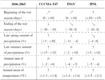
C. Length of the rainy season
The analysis of the length of the rainy season indicates that the dry season is likely to be longer in 2046-2065 owing to a delay in the onset of the rainy season (up to 15 days) accompanied by an earlier end of the rainy season (up to 30 days) (Table V). The annual rainfall total will probably remain stable but the seasonal distribution of rainfall will change. Yet, if evolutions remain unclear in spring, precipitation recorded in the late summer summit is likely to increase. The same conclusions can be drawn for the 2081-2100 period. The future climate of the Province of Binh Thuan will therefore be characterized by a longer dry season and concentrated rainfall in the summer with an increase in extreme rainfall events.
TABLE V. SUMMARY TABLE OF THE ANALYSIS OF THE
CLIMOGRAPHS OF THE THREE MODELS ON THE PERIOD 2046-2065.#
# The evolution is represented by the arrows and refers to the past climate. The range shows the minimum and maximum value of the scenarios. ↑ : the evolution is strictly positive; : the evolution is positive or equal to zero; → : the evolution is equal to zero; : the evolution is negative or equal to zero; ↓ : the evolution is strictly negative; ø : the evolution has no general trend.
TABLE VI. SAME AS TABLE V FOR THE PERIOD 2081-2100.
V. DISCUSSION AND CONCLUSION
As expected at the global scale, future climate in the Province of Binh Thuan should be characterized by higher temperature of about 1.6°C (over 2046-2065) and 2.5°C (over 2081-2100) and an increase of extreme temperatures and extreme rainfall events.
Although it must be kept in mind that precipitations are the most difficult climate variable to predict, it is likely that increasing water needs to support expending agriculture within the context of climate change in the Province of Binh Thuan will be a challenge. Yet, extreme rainfall events are likely to increase and unchanged yearly amounts of precipitation should be concentrated in time. A recent survey (March 2011) realized amongst farmers, water resources planners, and the agriculture administration points out that water needs are currently not met. What will happen in the next decades if the dry season extends and that the agriculture switches towards more intensive and irrigated crops? Our results may help future land use planning.
In the meantime, since the area of concern is already highly prone to flood hazard, water management should become a top priority of local authorities in order to reduce future exposure and vulnerability of the population.
REFERENCES
[1] Core Writing Team, R. K. Pachauri, and A. Reisinger, Climate Change 2007: Synthesis Report. Contribution of Working Groups I, II and III to the Fourth Assessment Report of the Intergovernmental Panel on Climate Change. IPCC, Geneva, Switzerland, 2007.
[2] T. Pham Anh and K. Shannon, “Urbanization and climate change in Vietnam: a case study of Hanoi,” In: M. De Dapper, D. Swinne, and P. Ozer, Eds. Developing countries facing global warming: a post-Kyoto assessment, Académie royale des Sciences d’Outre-Mer, Brussels, Belgium, 2010, pp. 203-220.
[3] Y. Biot, “Towards a strengthened climate deal. A brief scientific and historical context of the global policy response to climate change,” In: M. De Dapper, D. Swinne, and P. Ozer, Eds. Developing countries facing global warming: a post-Kyoto assessment, Académie royale des Sciences d’Outre-Mer, Brussels, Belgium, 2010, pp. 295-325.
[4] World Bank, The economics of adaptation to climate change. The World Bank Group, Washington DC, 2010.
[5] P. Chaudhry and G. Ruysschaert, “Climate change and human development in Vietnam,” Human Development Report Office, Occasional Paper 2007/46.
[6] S. Nieuwolt, “The climates of continental Southeast Asia,” In: K. Takahashi and H. Arakawa, Eds., Climates of Southern and Western Asia, Elsevier, Amsterdam, Netherlands, 1981, pp. 1-66.
[7] C.V. Nguyen, “Poverty projection using a small area estimation method: Evidence from Vietnam,” Journal of Comparative Economics, in press, doi:10.1016/j.jce.2011.04.004
[8] V.H. Linh, “Vietnam’s agricultural productivity: a Malmquist index approach,” Vietnam Development Forum, Working
Paper 0903, May 2009.
http://www.vdf.org.vn/workingpapers/vdfwp0903
[9] Y. C. Hountondji and P. Ozer, “Land cover change analysis 1990-2002 in Binh Thuan Province, south central Vietnam,”
paper presented at the 1st International Conference on Energy, Environment and Climate Changes, Ho Chi Minh City, Vietnam, 27th and 28th August, 2011.
[10] ECWMF: European Centre for Medium-range Weather Forecast. http://www.ecmwf.int/
[11] NCEP-NCAR: National Centre for Environmental Prediction - National Centre for Atmospheric Research http://www.cpc.ncep.noaa.gov/
[12] S. Solomon, D. Qin, M. Manning, Z. Chen, M. Marquis, et al., Climate Change 2007: The Physical Science Basis. Contribution of Working Group I to the Fourth Assessment Report of the Intergovernmental Panel on Climate Change. Cambridge University Press, Cambridge, United Kingdom and New York, NY, USA, 2007.
[13] J. Leloup, M. Lengaigne, and J. P. Boulanger, “Twentieth Century ENSO characteristics in the IPCC database,” Clim.
Dyn., vol. 30, pp. 277-291, 2008, doi:10.1007/s00382-007-0284-3
[14] Global Carbon Project, “Carbon Budget 2009,”
http://www.globalcarbonproject.org/, 20 January 2011. [15] M. De Dapper, D. Swinne, and P. Ozer, Developing countries
facing global warming: a post-Kyoto assessment. Académie royale des Sciences d’Outre-Mer, Brussels, Belgium, 2010. [16] S. Doutreloup, X. Fettweis, P. Ozer, “Analysis of the
evolution of the climate parameters, especially precipitations and temperatures, in the province of Binh Thuan in Southern Vietnam based on IPCC models,” Scientific Report. 30 p. URL: http://hdl.handle.net/2268/92711.
[*] Higher resolution format of Fig. 2 is available from: