Strategic assessment of urban cultural heritage : the case of Old Town
Square in Prague
Tomas Drdacky (1), Jacques Teller (2)
(1) ITAM, Advanced Research Centre for Cultural Heritage Interdisciplinary Projects (2) Université de Liège, Laboratoire d’Etudes Méthodologiques Architecturales
Abstract
Old Town Square has continued to be the focus of social, cultural and economic life in Prague, despite its image and physical structure changed dramatically over the centuries. Its continued vitality and viability however remain a challenge for policy makers and practitioners. This paper highlights how research techniques first developed as part of EC funded research but subsequently tested and applied within the square as part of student training and project work, sought to address some key issues. These included trying to determine the current role and function of the square in relation to the rest of the city centre and to offer innovative tools and research techniques to help decisions affecting ongoing urban formation. The paper, which represents a collaboration between the SUIT and ARCCHIP research teams, shows some of the evaluation criteria applied and measured within the square and the results which emerged.
Key words
Urban Cultural heritage, Strategic Environmental Assessment, Morphology
1. Introduction
The central market space of Old Prague- Old Town Square has continued to be the focus of social, cultural and economic life in Prague, even though its physical structure and image have continuously changed over the centuries. These changes reflected the functional needs of the developing city. Like in many European cities, the square once vast in area but with human scale of buildings, with rich everyday working, commercial, cultural and social life has been continuously changing with the rhythm of the whole city.
Fig.1 - Historic views of the town hall from east 1787, 1900, 1929, 1945
The first widely discussed change in the urban pattern occurred in 1900 with the clearing of the old Jewish ghetto and the introduction of the large Paris boulevard in the axis of the square. This “haussmanian” intervention required demolishing the Kren house, which was closing one corner of the open space (Fig. 1). Its demolition dramatically changed the urban pattern and the character of the central area of the Old Town. Since this period, various projects have been proposed to remodel the northwest corner of the square which was considered as unfinished. These projects further questioned the neo-gothic wing of the Town Hall that was criticized for being out of scale when compared to other civil buildings of the square after its transformation in the XIXth century.
Architectural competitions for reconfiguring this corner of the place were organized in 1901, 1904, 1909 and 1938. They resulted in both very conservative and visionary designs and concepts (Architektura ČSR 1988). This issue came back to the fore with greater emphasis after the second World War. The damage caused by the bombing of the eastern neo-gothic wing of the Town Hall once appeared as an opportunity to remove the building and stimulate
a new development of the site. The configuration of the square hence definitively changed. The previously enclosed public space, dedicated to open air commercial and cultural activities, had progressively been transformed into a junction of streets and walkways with new composition, views, openings and links with surrounding buildings. That state was largely found unsatisfactory by the municipal authorities and several architectural and urban design competitions took place from 1946 to 1987 in order to reorganise the space which was still perceived as the symbolic heart of Prague.
Fig.2a View of the town hall in its 2002 state, 2b, ortofotographic view of the square (by Gefos s.r.o.)
The perceived need to solve the unsatisfactory image of the area was not accompanied by a clear and justifiable demand for new functions which should be accommodated in a new building located on this site. Quite interestingly the lack of programme facilitated an open and unconstrained debate about the “ideal form” of the open space. Still, on the other hand, it may partly explain why none of the proposals has ever been built and why this corner of the square keeps today an unfinished allure (Fig.2).
The questions of harmony, balance, gap or unfinished state of the square are left open and are challenging architects and city planners. What is the role of the Old Town Square in today’s Prague city centre structure? What should be the evaluation criteria, which indicators of the built environment are worth to be assessed? What is the role of the public in this debate and what are the needs to be taken into consideration?
2. The collaboration between SUIT and ARCCHIP
Research into historic urban areas had a strong position within the ARCCHIP activities and was focused on the role of cultural heritage in urban areas, in local and regional social and economic stability. It involved problems of documentation and interpretation of cultural heritage and especially discoveries concerning geometry of urban tissues. Other short term activities of the Centre were related to analysing the historical built environment taking into account historical material, structures and technology.
Importantly, ARCCHIP facilitated and supported co-operation and visits by EU and International researchers. Complex studies of the historical built environment were undertaken in this framework, focussing not only on historical material, structures and technology but also on the integration of such environments in the contemporary society.
Exchange of researchers provided the opportunity to test results arising from the SUIT research project dedicated to the Sustainable development of Urban historical areas through an active Integration within Towns. Urban historical areas were the main focus of SUIT and, in contrast to most other research into built cultural heritage, this project explicitly looked beyond individual buildings to consider the urban context of cultural spaces.
One of the objectives of the SUIT project was to develop tools and methods devoted to historical areas quality analysis in order to support Strategic Environmental Assessments
(SEA). Perception and Attitude surveys together with results of Computer 3D modelling are among the tools and methods which have been developed in this perspective. They help to analyse historic areas with the aim to be more sensitive to the needs of those living, working and visiting historic spaces.
The SUIT methodology has been applied within Old Town Square in order to analyse how changes in the morphology of the space may affect the square’s character. Two main methods were tested: the morphological indicator system developed by LEMA-Université de Liège (Teller, 2003) and the public perception survey developed by Queens University Belfast (Sutherland & Drdácký, 2002). The present paper will concentrate on the morphological indicators and will analyse how the opening of the Paris Street in 1900 dramatically changed the morphological configuration of the square. It further aims to establish what would be the effects of some alternatives proposed until now in the view of facilitating the definition of strategic options for the reconfiguration of the open space.
3. Selection of relevant alternatives for a strategic assessment
Different attitudes can be adopted towards the existing urban fabric. Some of the projects proposed until now tend to mimic past building in its plan and facades while other projects rather tend to innovate and generate a new spatial dynamic. It has been considered that the past 252 architectural proposals compiled by the Architektura ČSR review in 1989 provided a sound basis to explore the diversity of solutions that could be adopted.
These 252 projects were hence classified according to a typology built after a close observation of each project main characteristics. Two different ways were proposed to organise the set of projects. The first structure was organised along a “solution tree”, based on five criteria and 32 possible combinations of these five criteria along which to classify the proposals:
• visibility of the façade of St Nicolas Church from the open space (yes/no), • obstruction of the view towards Paris Street (yes/no),
• use of ground surfaces to delineate the open space (yes/no), • creation of a small open space before St Nicolas Church (yes/no),
• introduction of vertical elements to counterbalance the Town Hall tower (yes/no) The second structure is organised as a table with two entries: the accessibility graph of the place and the overall skyline of the building (Fig 3).
Accessibility graph of the place
Project 218 Project 9 Project 50 Project 10 Project 160 Project 28 Project 167 Project 133 Project 97 Project 72 Project 52 Project 213 Project 79 Project 64 Project 34 Project 94* Project 100 Project 41 Buil di ng sk ylin e Project 39 Project 132 Project 108 Project 219 Project 159
Fig.3 – Table of the different possibilities with examples of projects from previous competitions (Amati V. et. al., 2003)
Organising all proposed projects along these two structures facilitated the identification of relevant morphological criteria to be considered before any possible transformation of the place. These two typologies can indeed be used to “test” the robustness of a given criteria as an impropriate definition will either lead to gather most proposed project into one single branch or, at the opposite, to reject all of them. Furthermore it can be seen from the table structure (Fig 3) that some combinations of criteria are either impossible or have never been considered until then, which opens again the solution space.
A combination of these two structures was then used to select ten alternatives from the 252 projects for the reconstruction of the town hall proposed during one of the latest architectural competitions in 1987. The ten alternatives are:
• the no project or the place as it is since the destructions (present state), • the place as it was before the 1945’s destruction (old),
• three variants of a place with decreasing enclosure of the town hall block (projects 2, 3 and 4),
• 4 variants of the place as it was before the destructions, with a building covering its entire border (projects 5 to 9).
A 3D model of the place and its surrounding as well as of the ten alternatives studied has been realised. It was based on topographic, historic documents and a photographic survey of all the building facades achieved during the winter 2002.
The morphological analysis of these different projects considered the following criteria identified through the classification of projects: overall silhouette of the square, articulation of the different sub-spaces and the Paris street and dynamic perception of the open space.
4. Comparison of old and present situations
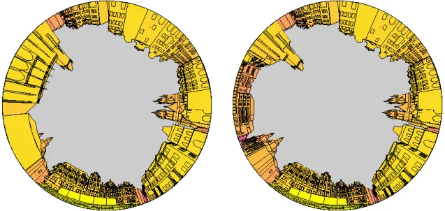
Stereographic views are synthetic representations of an entire open space with a 360 degrees angle. These views enable the analysis of the three-dimensional relationships between buildings and open spaces, as well as between different buildings.
Fig. 4 – Comparison of old (left) and present (right) situation
Stereographic views of Old Town Square before and after the 1945 demolitions (Fig 4) highlight that the town hall does now appear as an object inserted into a squared space while it was perceived as bordering a rectangular space beforehand. The skyline continuity is no longer legible, disturbed as it is by the isolated tower of the Town Hall and St Nicolas church, that are no longer inserted within the urban pattern. The main monuments strengthen their
position within the square: St. Nicholas, Town Hall Tower and Tyn Church are dominating the open space.
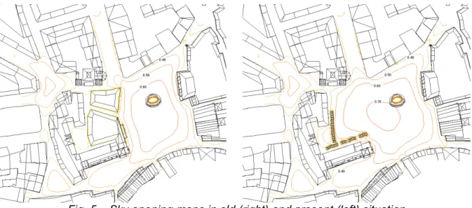
Sky opening maps are complementary to stereographical views. They allow one to visualise and quantify the variation of perceived building masses throughout an open area. In the case of Old Town square (Fig 5), they highlight that the overall shape of the open space has been transformed from a north-west rectangle to a square including the town hall. The sky opening at the centre of the place is much larger in the present configuration (70%) than it was beforehand (60%). Furthermore the centre of mass of the place has been clearly shifted to the west.
Fig. 5 – Sky opening maps in old (right) and present (left) situation
In the past configuration, the limits of the open space were quite clear and marked by a sharp decline of the sky opening along the different borders. The south-west opening was characterized by a slow decline of the sky opening in the direction of a small triangular space at the SW. The size of the town hall was not sufficient to close the open space located at its south, which was clearly connected to the main rectangle. This is not modified in the present state, but the specificity of this appendix is now “blurred” by the opening on the north of the town hall as well as the opening towards Paris street.
It can be observed that, in the old situation, the perspective on St Nicolas Church was closely framed by the back of the town hall and Kren’s house. The scale of the façade when compared to the highly confined space it was facing was certainly contributing to increasing its dramatic effect. In the present situation the façade is directly visible from the place, whose scale is comparable if not superior to the one of the church.
5. Comparison with other alternatives
As regard these two possible configurations of the open space, the eight alternatives we studied helped to draw the following conclusions.
Building a single block aside the town hall would almost be sufficient to come back to the initial spatial configuration, in terms of spatial opening and location of the centre of mass (Fig. 6). By contrast with the old situation it would still allow direct views to St Nicolas Church from the open space. This configuration would maintain the competition between two main axes defining the present open space and would increase the dynamism of the open space as regard with the ancient situation. It can further be observed that this configuration is sufficient to recreate an autonomous open space at the back of the town hall.
Fig. 6 – Sky opening maps of the situation before 1945 (right) and project 4 (left)
Another option would be to exacerbate the present situation by inserting another small volume within the squared open space (Fig 6). This would maintain a spatial continuity within the entire open space, while introducing new axes and more dynamism. It can be seen that the proposed volume is not sufficient to create an autonomous open space at the back of the new building. Still the sky opening of the place is lowered at 60% as it was in the past, and the location of the central area is closer from its original one. Quite interestingly such an element would introduce a new focal point in the perspective of Paris street, which may help to articulate both remarkable spaces. Further analyses should be done to check whether this new focal point does not interfere excessively with the town hall.
Fig. 7 – Sky opening maps of projects 6 (up left) and 7 (up right)
The projects 5 to 9 essentially differ along two dimensions: the treatment of the sub-space in front of St Nicolas Church and the visual accessibility between this place and old town square. These schemes are based on an axial view upon the St-Nicolas church characterised by a much shorter distance that maximises the baroque effect of the façade. They all tend to close the perspective towards Paris street. Most schemes reinforce the NE-SW axis of the old town square. Projects 6 and 7 (Fig 7) introduce new sub-spaces at the southwest corner of the place. It can still be argued that some of these projects do not fully resolve the question of the Paris street, given the way sky opening is disturbed at this corner of the place.
6. Conclusion
Given its symbolic character and international heritage value, Old Town Square is certainly a place where any major transformation of the urban fabric would gain to be assessed prior to the formulation of any concrete project. Such a strategic forward-looking way of thinking is presently promoted by the European Directive 2001/42/EC dealing with the Strategic
Environmental Assessment of the effects of certain plans and programmes upon the environment. It has been stressed by the SUIT research that this Directive should be applied
to a number of urban transformation projects within historical areas.
Although there have been a number of competition to reorganise Old Town Square north-west corner, the issue of the programme of the future building to locate in this place has never been seriously addressed until now. There is simply no urgent need for building a new construction at this place. Quite interestingly the lack of programme and local guidelines stimulated a wide divergence of projects and attitudes to the existing place, from pure mimicry to some more radical transformation of the present organisation.
The application of the SUIT methodology to Old Town Square obviously benefited from the diversity of proposed solutions so as to identify relevant criteria structuring the solution space. A decision on these criteria would certainly be required before any serious attempt to restructure the open space. A design brief would certainly constitute an important output of a more comprehensive SEA of the place restructuring.
Morphological analyses confirms that building anew the Town Hall and Kren’s house would certainly contribute to restore the coherence of Old Town Square as it was until the beginning of the XIXth century. It is not the place here to discuss the relevancy of such an
option. It should however be stressed that the new buildings would block the perspective of Paris’ street and most probably deteriorate its present character when the heritage value of this urban ensemble can no longer be denied.
The exercise further revealed that a small intervention was capable of a deep reorganisation of the open space. It affects both location and magnitude of the central zone of sky opening. It can also affect all orientation system of the place while maintaining Paris’ street perspective and view on the place.
Finally, large projects blocking Paris’s street views are all failing to coherently articulate the views on the different landmarks of the place (St Nicolas Church, Tower Hall and Tyn Church). Still it should be stressed that the proposed morphological indicators do not provide a basis to decide whether such solutions are intrinsically good or bad. It just gives an indication of the structure of the open space after its reconfiguration. The interpretation of such transformation will always require some collaborative work between experts and decision-makers.
Aknowledgement
The research was carried out as a collaboration between two EC funded projects: SUIT (Sustainable Development of Urban Historical Areas Through an Active Integration Within Towns – EVK4-2000-00540) and ARCCHIP (Advanced Research Centre for Cultural heritage Integrated Projects – ICA1-CT-2000-70013).
References
Amati, M., Belleflamme, M, Descamps, M, Guadagno, R, Analyse de divergence, Internal report, available from LEMA, 45 p., 2003.
Architektura ČSR, 1988, number 5.
Baše, M., Conservation of Historic Monuments and Sites, CVUT Published by CTU, Praha, 2000.
Bečková, K., Guidebook to the Langweil’s model of Prague, Prague Municipal Museum, 1986
Digital map of the Old Town Square, IMIP, Praha, 2003
Drdácký, M (2001), “Telc, Czech Republic” in Pickard, R (Ed) Management of Historic
Centres, Spon Press, London and New York, pp 31-50
Drdácký T., Teller J., Sutherland M. (2004), “ARCCHIP and SUIT - Urban research cooperation in the enlarged European Union”, Presentation at the 6th EC Conference on Sustaining Europe’s Cultural Heritage: from Research to Policy, 1-3 September 2004. Published on UCL website.
El Mimouni, A, Miller Jones, Y: Analyse qualitative de Old Town Square (Prague), Internal report, available from LEMA, 18 p., 2003.
Hypšman, B.: Sto let staroměstského rynku a radnice, 1. vydání, Praha : Polášek, 1946, 52 s.
Kibic, K.: Staroměstská radnice v Praze, in: Staletá Praha, V, Praha 1971, s. 33- 63. Líbal, D., Muk, J.: Staré město pražské. Architektonický a urbanistický vývoj. Praha 1996. Lucca, V, Polis, Q, Sauvage, R, Analyses en champ continu, Internal report, available from
LEMA, 18 p., 2003.
Maier, K., Hexner, M., Kibic, K.: Prague-Urban History and Development, CTU, Praha, 1998. Muzeum hlavního města Prahy, 2002. Morstadt, Vincenc, 1802-1875. Praha v díle Vincence
Morstadta. Cást 2., Soupis grafických listu a kreseb.
Peetersille, C, Mottard, W, Minchilli, F, Moonen, A-C, Analyse des cheminements appliquée
à la vieille ville de Prague, Internal report, available from LEMA, 26 p., 2003.
Semrád, S., Přestavba Staroměstské radnice v Praze, Architekt SIA, volume 37, pp.125-144, 1938.
Staňková, J., Štursa, J., Voděra, S.:Prague: Eleven Centuries of Architecture. PAV Publishers, Prague 1992.
Sutherland, M and Drdacky M, (2003) Application of SUIT methodology for measuring
perceived quality and attitudes within urban historical spaces. Analysis and findings from the Czech Republic: Telc and Prague Technical Report 0301, School of
Architecture, Queens University Belfast
Sutherland, M, Teller, J and Tweed, C (2002) Preference Surveys as an Affordable Built
Heritage Scoping Method Position Paper Number 3, Deliverable under EC funded
SUIT project (EVK4–CT-2000-000017 SUIT) Technical Report 0203, School of Architecture, Queens University Belfast)
Teige, J, Herein, J.: Staroměstský rynk v Praze, Praha 1908.
Teller J. (2003), « A spherical metric for the field-oriented analysis of complex urban open spaces », Environment and Planning B: Planning and Design, 30(3), pp. 339–356. Umělecké památky Prahy 3. Staré Město, Josefov. Praha 1996.
Vojtíšek, V.: Čtení o Staroměstské radnici v Praze, Praha 1926. Wirth, Z., Praha v obraze pěti století, 2.vydání.