HAL Id: hal-01191180
https://hal.archives-ouvertes.fr/hal-01191180
Submitted on 1 Sep 2015
HAL is a multi-disciplinary open access
archive for the deposit and dissemination of
sci-entific research documents, whether they are
pub-lished or not. The documents may come from
teaching and research institutions in France or
abroad, or from public or private research centers.
L’archive ouverte pluridisciplinaire HAL, est
destinée au dépôt et à la diffusion de documents
scientifiques de niveau recherche, publiés ou non,
émanant des établissements d’enseignement et de
recherche français ou étrangers, des laboratoires
publics ou privés.
Impact on erosive runoff and costs for local communities
of agricultural-soil-use-change scenarios: the case of
Pays de Caux (France)
Philippe Martin, Céline Ronfort, Dimirti Laroutis, Veronique Souchere,
Clementina Sebillotte
To cite this version:
Philippe Martin, Céline Ronfort, Dimirti Laroutis, Veronique Souchere, Clementina Sebillotte. Impact
on erosive runoff and costs for local communities of agricultural-soil-use-change scenarios: the case of
Pays de Caux (France). Producing and reproducing farming systems. New modes of organisation for
sustainable food systems of tomorrow, International Farming Systems Association (IFSA). AUT., Jul
2012, Aarhus, Denmark. �hal-01191180�
Impact on erosive runoff and costs for local communities of
agricultural-soil-use-change scenarios: the case of Pays de Caux (France)
Martin, P.14, Ronfort, C.2, Laroutis, D.3, Souchère, V.41,Sebillotte, C.5 1
AgroParisTech, UMR 1048 SAD-APT, 16 rue Claude Bernard, F-75231 Paris, France 2
Cirad, UMR Tétis, Département Environnement et Sociétés, TA60/F, Campus de Baillarguet-34 398 Montpellier Cedex 5, France
3
ESITPA, 3, rue du Tronquet, BP 40118, Mont-Saint-Aignan cedex, France 4
INRA, UMR 1048 SAD APT, 16 rue Claude Bernard, F-75231 Paris, France 5
INRA, UR 1303 ALISS, F-94205 Ivry-sur-Seine, France
Keywords: mudflows, foresight, dairy farming, grass, willingness to pay
Abstract
Recurring mudflows in the silty areas of North-West Europe and particularly in Pays de Caux (France) result in significant costs for local communities. These flows result from erosion processes which occur on agricultural land located upstream of urban areas. Farming practices depend on changes in
external factors (prices, regulatory system) that may lead to an increase in erosion and mudflows issues. Public-action programs can limit the possible damage of these changes but any strengthening of these policies (compensation for farmers) induces costs for the community. Our goal is to examine the economic feasibility of action programs designed to counter some agricultural scenarios driven by changing external factors. To do so, we compared the cost of compensating farmers with the local populations’ willingness to pay (WTP). We built scenarios of changes in farming systems with a 2015 horizon at the scale of the Pays de Caux, 2007 being the initial situation. We chose two scenarios of the disappearance of dairy farming, since local stakeholders were concerned with the future of local livestock farming and particularly by trends of declining dairy farming. One scenario (StopMilk) did not include any public-action program, the other one (StopMilkEnv) involved a program based on the funding of environmental-friendly cultivation techniques . These scenarios were assessed at the small watershed scale (7 km²) in terms of both changes in farming systems and effects on runoff. Finally, the economic evaluation of additional costs of StopMilkEnv was extrapolated at the level of the
Austreberthe watershed syndicate1 (214 km²). Our results show that StopMilk leads to a significant increase in runoff, whereas the local public-action program proposed with StopMilkEnv reduces runoff below the 2007 level. The willingness to pay of the residents of the Austreberthe watershed for a 5 years program was around €395,000/year and a comparison with the cost of the environmental-friendly cultivation techniques revealed that the funding of such practices would be possible but would require borrowing by the community.
Introduction
Recurring mudflows in the silty areas of North-West Europe have significant economic impact (Evrard
et al., 2007). These mudflows result from erosion processes occurring on agricultural land located
upstream of urban areas and depend to a great extent on farmers’ agricultural practices. These practices tend to change due to external signals (prices, sales channels, innovation, etc.), which are
1
A watershed management syndicate is an organizational management structure in France, spanning several communes, that manages all matters relating to water erosion and its consequences within its geographical ambit.
often difficult to predict thus rendering difficult the implementation of any public policy aiming at reducing mudflows through changes in agricultural practices. In such a context, foresight appears to be a useful tool for framing future public policy (Godet, 2000). Once the current and future processes underlying the functioning of the studied system are identified, one can build scenarios of evolution of the system (Sebillotte and Sebillotte, 2010) in order to explore as-yet-unknown situations and to prepare for them.
The objectives of our study, which involves agronomists as well as economists, are to (1) construct scenarios of the possible evolution of agricultural production systems and their environment, (2) evaluate these scenarios in terms of the risk of an increase in erosion processes and (3) quantify the costs for local communities wishing to create incentives for changing agricultural practices to counter undesirable scenarios and to compare this cost with the local populations’ willingness to pay.
Material and methods
We conducted our study at three scales. The department2 scale, relevant for changes in the main drivers such as supply chain structure, has been chosen for scenario construction. The small
watershed scale, relevant for runoff processes, was used for mudflow risk assessment. The watershed syndicate scale, relevant for the management of mudflow issues, was used for economic assessment. We built scenarios for the department of Seine-Maritime (France), regularly facing mudflows,
especially in its northern part (Pays de Caux). This area is an agricultural plateau made up of silty soils and subject to heavy precipitations (800 to 1000 mm/year). Local interpretation of the Seine-Maritime scenarios was made at the level of the Saussay agricultural watershed (7 km²) in southern Pays de Caux. The Saussay watershed with its diverse production system, is sensitive to a wide range of scenarios involving changes in either cropping or livestock systems. Farmland accounts for 87% of the watershed area and is farmed by 23 farmers: 5 of them have cereal farms (CF), 13 have mixed dairy farms (DF) and 5 have mixed suckler farms (SF). Costs were then calculated at the scale of the Austreberthe watershed syndicate (AWS, 214 km²), north of which lies the small Saussay watershed. The willingness to pay for the AWS was estimated from studies conducted at the nearby Commerce watershed.
3 stages of the approach applied to different scales
Stage 1: Construction of scenarios at the department scale
The scenarios were constructed using the SYSPAHMM foresight method (Sebillotte and Sebillotte, 2010). The subject under consideration was the evolution of farming systems leading up to 2015 and starting with 2007 as a baseline. In this paper, we selected two scenarios.
The StopMilk scenario: In this scenario, the territory loses its traditional milk production in favor of cereal crops. These latter are less diverse than in 2007 due to the disappearance of sugar beet and protein peas and to the reduction in area under flax cultivation, all in a context of rural exodus and local authorities disinterest towards environmental quality, which manifests itself by inadequate regulatory constraints (Ronfort et al., 2011).
The StopMilkEnv scenario: This scenario is the same than the previous one, except that it envisages stricter environmental regulations for farmers. According to French regulations, these additional constraints will require, at least initially, compensation to be paid to farmers for increased costs due to environmental-friendly cultivation practices.
These twin scenarios were of particular interest to local experts who were called upon for their expertise, because they concerned dairy farming, an important source of local employment.
Furthermore, because of the reversion of grasslands to crop farming that they envisage. Furthermore, because of the presence of environmentally friendly public action in one case and its total absence in
2
the other, these two scenarios represent extreme cases for estimating the economic costs to the local community of combating the problem of runoff.
Stage 2: Environmental evaluation of scenarios
The two scenarios, constructed at the scale of the Seine-Maritime department, were then described at the local scale.
Description of scenarios at the local scale
The tested scenarios include qualitative information on the evolution of surface areas of different crops (Ronfort et al., 2011). This qualitative information was combined with rules for undertaking crop rotations, which were elicited during farmer surveys at the Saussay site and processed using the LandSFACTS computer model (Castellazzi et al., 2010) to arrive at a quantification of this site’s data. The LandSFACTS model allowed us to generate a succession of crop allocations3 to fields of each farm considered. As a subsequent step, we aggregated the individual farm allocations to obtain equiprobable watershed configurations4. For each of the three reference contexts (2007, StopMilk and StopMilkEnv), we generated 50 watershed configurations, i.e., 50 combinations of land occupation and use consistent with the context under evaluation.
Impact on runoff of local representation of scenarios
The impact of watershed configurations on the erosive runoff was assessed using the STREAM model, calibrated for the Pays de Caux (Cerdan et al, 2002). STREAM is a spatial model for agricultural watersheds and runs under ArcGIS®. Starting from a rainfall event (rainfall amount, duration of rain and rain during the previous 48 hours), the watershed topography, the field pattern and their surface states5, STREAM generates a runoff-concentration network and calculates the runoff all along this network until the outlet of the watershed. The scenarios were tested for the two periods at risk of runoff: December and May. For each of these two dates, we used two rainfall events for our simulations: RA and RB. RA and RB correspond to similar amounts of rainfall (22.0 and 29.6 mm respectively) but RA is rainfall during a thunderstorm, whereas RB is a less intense rainfall. The events tested would be called significant but not exceptional (such as those that happen less than once in 10 years).
Stage 3: Economic evaluation of the StopMilkEnv scenario
The additional costs of implementing environmentally-friendly farming practices are compensated via aid disbursed by the community. This aid depends on the area under cultivation and on the type of crop planted. The first step of economic evaluation therefore has to be a calculation of the area under cultivation of each crop type for the 2015 scenarios for the Austreberthe watershed. The second step consists of evaluating each practice’s additional cost to the farmers so as to arrive at amounts to be disbursed by the community. These amounts are then compared to the local populations’ willingness to pay.
Calculation of areas under cultivation at the end of StopMilkEnv
The StopMilkEnv scenario is based on the disappearance of dairy farms and the consequent reduction in grassland areas. The identification of dairy farms is therefore a prerequisite for the implementation of the StopMilkEnv scenario. We used a spatial database that covers the entire Austreberthe
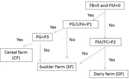
watershed (400 farmers), the Graphical Field Registry (French abbreviation: RPG). The RPG provides, for each farm, on an anonymous basis, the location of crop islets as well as crop types and the areas under cultivation in these islets. From surveys conducted at the Saussay site, we drew up a decision tree to assign a farm to one of the three farm types (SF, CF, DF) solely on the basis of information available in the RPG (Figure 1).
3
Allocation: spatial allocation of crops to fields at the farm scale.
4Configuration: spatial allocation of crops to fields at the watershed scale (combinations of the different allocations at the farm scale).
5 Surface state = state of crusting, roughness, vegetation cover. To obtain information on the land surface conditions at the two selected periods, we used grids of correspondence between land use and surface states described by Joannon (2004).
Figure 1: Decision tree for classifying farms into 3 classes based on the RPG database for the Saussay site where P1=0.3, P2=0.15, P3=15 ha (DF=Dairy Farm, SF=Suckler Farm, CF=Cereal Farm, FB=Forage Beet area, FM=Forage Maize area, PG=Permanent Grass area, UFA: Usable Farm Area, FC=Forage Crop area)
It is this grid for the Saussay site which was then implemented for the entire Austreberthe watershed. Surveys conducted at the Saussay site showed that the PGm/PG ratio (parameter P4) influenced the evolution of farms that ceased milk production (PG = permanent grass area; PGm = PG mandatory, the part of the PG that cannot be cultivated due to reasons specific to the farmer: steep slope, soil type, field size, leasing restrictions, etc.). P4 was estimated to be 25% for the AWS. Using this value and based on Ronfort et al. 2011, we considered that dairy farms which, in 2007, had more than 5 ha of PGm (20 ha of PG) moved towards becoming suckler farms. The others transformed themselves into cereal farms. Forage crops such as maize and fodder beets disappeared in all cases.
Areas released from the various crops are allocated to other crops. We have 3 components in the released areas (RA): RA1, RA2 and RA3. RA1 concerns all the farms and represents the
disappearance of peas and sugar beets whose areas under cultivation are known from the RPG 2007 database. RA2 concerns dairy farms whose conversion releases areas used for growing forage crops (Permanent grass, corn silage and fodder beet). RA3 concerns farms that were growing flax in 2007. The area released by the reduction in flax production depends on its relative importance in 2007. Flax is a speculative crop that requires technical expertise to farm. When prices rise, non-specialist farmers are attracted to it and opportunistically grow small quantities without taking too much risk. These same farmers then abandon the crop when prices fall (case of the StopMilkEnv scenario). Flax is also cultivated by specialist flax farmers who plant it over much of their land. While the minimum crop return period for the same field is 6 years for flax, these farmers can reduce it to 3 years when prices rise. Consequently, we considered a farmer to be a non-specialist when the proportion of flax on his farmlands was equal to or below a parameter P5 (set at 5% for the AWS). These areas are fully released in the StopMilkEnv scenario. A specialist farmer is one whose area under flax cultivation is greater than 16.6% of his 2007 farmland area (1/6th of the area). Flax areas above 16.6% in 2007 were reduced to 16.6% in StopMilkEnv. Farms with flax between P5 and 16.6% maintained their crop rotation. For each farm identified in the RPG, Released Areas = RA1 + RA2 + RA3. Farming areas remain unchanged with areas released from various crops going to the remaining crops, i.e., wheat, barley and rapeseed, while maintaining the ratios between the areas of these 3 crops at their 2007
level. This calculation was made for all farms having at least one field in the Austreberthe watershed by suitably weighting those crop rotations in the farm’s land which were actually within the
Austreberthe watershed syndicate.
Calculation of additional costs incurred due to changes in farming practices
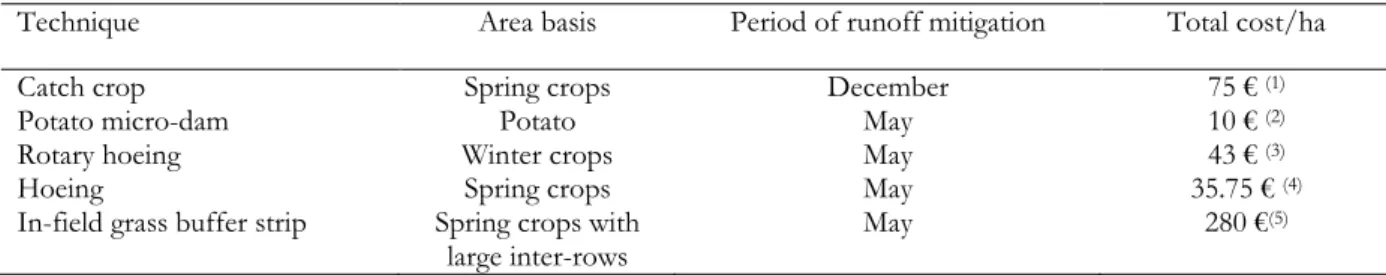
The cost of environmentally-friendly practices mandated in StopMilkEnv is obtained by multiplying the per hectare cost of individual techniques (table 1) by the area under cultivation of the concerned crops after applying rules of farm conversion and of the changes in surface areas of each crop. The
calculated cost is a maximum cost since all areas liable to a change in farming practices have been taken into account, consistent with what was assessed with the STREAM model.
Table 1: Unit cost of farming practices implemented in the framework of the StopMilkEnv scenario
Technique Area basis Period of runoff mitigation Total cost/ha
Catch crop Spring crops December 75 € (1)
Potato micro-dam Potato May 10 € (2)
Rotary hoeing Winter crops May 43 € (3)
Hoeing Spring crops May 35.75 € (4)
In-field grass buffer strip Spring crops with
large inter-rows May 280 €
(5) Notes: the cost of farming practices refers to additional costs over and above the cost of current practices. (1) http://www.europedirectplr.fr/programmes/orientations-nationales-pour-le-feader-27.html
http://www.europedirectplr.fr/upload/file/PDRH_FEADER_2007_2013_tome4.pdf
(2) http://www.areas.asso.fr/images/formations/resultats_Gembloux_JP_Barthelemy.pdf
Purchase cost of 4000 € amortized over 10 years at the rate of 20 ha per year. (3) http://www.mayenne.chambagri.fr/iso_album/houe_rotative_1.pdf
(4) http://www.mayenne.chambagri.fr/iso_album/les_bineuses_1.pdf
(5) http://www.europedirectplr.fr/upload/file/PDRH_FEADER_2007_2013_tome4.pdf
Evaluation of the willingness to pay
To assess the local populations’ willingness to pay, we took recourse to the contingent valuation method (CVM) to quantify monetarily the values that individuals assign to an environmental good (Quiggin, 1998). Via a questionnaire, the CVM can reveal the individuals’ willingness to pay (WTP) for non-market goods. This method was used in the Valley of Commerce, which is very similar to
Austreberthe in many ways, especially in terms of its population’s socioeconomic status and the vulnerability of its territory to erosive runoff and flooding.
The questionnaire consisted of 48 questions and was divided into three parts. The first part concerned the respondents’ knowledge of the phenomenon of erosive runoff and its possible consequences in the Valley of Commerce. A set of questions determined whether they were familiar with the concept of erosive runoff, whether they were aware of any specific structures or arrangements to deal with it, etc. The second part aimed at determining the individuals’ willingness to pay (WTP) for a program to combat erosive runoff, in particular to prevent flooding in the Valley of Commerce. A description of an anti-flooding program was provided to them and their views on it were elicited. They were asked about their possible financial participation (spanning 15 years) through the property tax or via the
establishment of a special fund. It is indeed necessary for the payment mechanism to be credible (Mitchell and Carson, 1989). Finally, the third part collected standard socio-economic data such as the number of persons in the household, their education levels, the overall net household income, etc. The questionnaire was administered to adult residents (18 years or older) of the Valley of Commerce. The sampling method adopted was that of quotas by sex, age and socio-professional category (SPC). A total of 220 individuals were interviewed in person at their homes.
Results
We will focus on the results of stage 3 (Calculation of additional costs incurred due to changes in farming practices and comparison with the willingness to pay) and only list the as-yet unpublished results of the first 2 stages.
From the construction of scenarios to their local environmental assessment (stages 1 and 2)
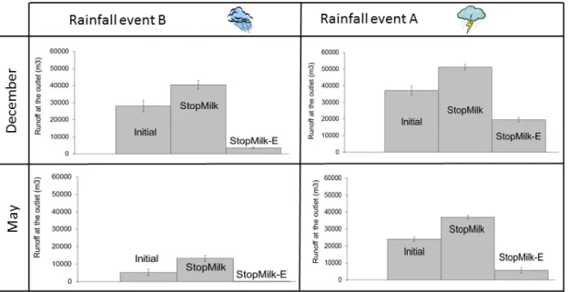
The StopMilk and StopMilkEnv scenarios lead to the same crop rotations, only the farming practices differ. The environmental assessment of these two 2015 scenarios (StopMilk and StopMilkEnv) is shown in figure 2. It appears that, for the Saussay watershed, the StopMilk (A) scenario results in a significant increase in the runoff compared to the initial state (2007). On the other hand, the specific farming practices implemented in the StopMilkEnv (B) scenario reduce the level of runoff to a level actually lower than in 2007, both for December and May and for both rainfall events. We thus show that a local public-action program can compensate for undesirable changes in the overall agricultural socio-economic context.
Figure 2: Runoff volume (m3) at the watershed outlet for A and B rainfall events in spring (May) and winter
Economic evaluation of the StopMilkEnv scenario (stage 3)
Cost of farming practices
The application of the decision tree to the 23 farms in the Saussay watershed yielded good results: it correctly classified 19 of the 23 farms. Applied to the entire Austreberthe watershed, this decision tree classified a total of 383 farms having at least one crop islet within the Austreberthe watershed as 226 dairy farms (59%), 112 suckler farms (29%) and 45 cereal farms (12%).
The total cost for Austreberthe calculated according to the principles presented in the method section is nearly 640,000 € which comes to 38 €/ha of agricultural land. This per-hectare cost is comparable, though slightly lower, than the calculation for Saussay with the same method (45 €/ha).
Determination of the willingness to pay (WTP) of the residents of the Austreberthe watershed
The factors behind the WTP were determined with a censored variable model (Tobit) (Amemiya, 1984) given the large number of individuals who expressed their WTP as equal to 0 Euros.
+
+
>
=
e
l
s
e
u
x
i
f
u
x
W
iT
i iP
i i0
0
β
β
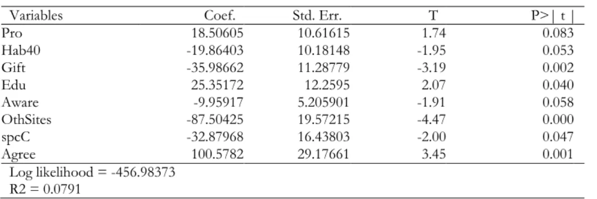
where xi corresponds to the explanatory variables which can take values of 1 or 0, β is the coefficient of these variables and ui is the random term following a normal distribution with a mean of 0 and a variance of σ2. The results show that being proprietor of a home (variable Pro), having a high SPC (the C SPC is the lowest) or a high level of education (Edu) leads the individual to declare a WTP higher than others (table 2). The level of education of the interviewees generally influences the WTP (Amigues et al., 2002). Good knowledge of the territory (Hab40) leads the interviewees to declare a WTP lower than others. This observation can be explained by the fact that, historically, the area has seen regular flooding, thus leading to some familiarity on the part of old-timers to this type of
phenomenon. Being aware of the flood risks at the time of property purchase or of moving to the area leads individuals to reveal a WTP lower than others. These individuals incorporate flood risk in their purchase decisions and are thus prepared to suffer the consequences of their decisions without having to pay more. Moreover, they have often taken specific measures in their homes to drastically reduce the impact of such phenomena. Finally, the willingness to give for other causes (which reflects the individual’s altruistic urges) or to pay for protection of other sites (gift) has a negative effect on the WTP.
Table 2: Tobit model applied to the Valley of Commerce
Variables Coef. Std. Err. T P>| t |
Pro 18.50605 10.61615 1.74 0.083 Hab40 -19.86403 10.18148 -1.95 0.053 Gift -35.98662 11.28779 -3.19 0.002 Edu 25.35172 12.2595 2.07 0.040 Aware -9.95917 5.205901 -1.91 0.058 OthSites -87.50425 19.57215 -4.47 0.000 spcC -32.87968 16.43803 -2.00 0.047 Agree 100.5782 29.17661 3.45 0.001 Log likelihood = -456.98373 R2 = 0.0791
Conditions on each variable for value = 1: Pro: is homeowner; Hab40: has been living there for more than 40 years; Gift: makes gift to charities; Edu: has a high level of education; Aware: is aware of flooding processes; OthSites: has preference for the protection of another site; spcC: belongs to the lowest SPC (C); Agree: agrees with the overall program structure
The mean WTP declared by the individuals surveyed for this preservation program is 22.63 € per year for 15 years. The aggregate WTP value for the entire program is around 570,000 € per year. Over 15 years, this works out to a total of 8.55 million Euros (undiscounted) from individuals for the mudflow-control program for the Valley of Commerce. For the AWS, if we assume the same mean WTP of 22.63 € per year, the amount would be around 395,000 € annually and 5.925 million Euros over 15 years. The annual amount of 395,000 € corresponds to 62% of our estimate of the cost of changing farming practices as envisaged in the StopMilkEnv scenario.
Discussion and conclusion
The model for calculating the practice modification costs (PMC) is based on five main parameters. The first three (P1, P2 and P3) concern the initial farm type, in 2007 (figure 2). P4 and P5 are related to the farms’ evolution from 2007 to 2015. P4 is the PGm/PG ratio and P5 is the minimum value of the ratio flax area/arable land area in 2007 which would lead to the abandonment of flax in 2015. The model’s results are most sensitive to the values of the P4 parameter. When P4 decreases, the area of the grasslands released when dairy farms are converted increases and these farms are more likely to
convert themselves into cereal farms in 2015. Thus, the cost to the community of fighting mudflows increases. The range of variations in PMC observed for variations in P4 (0.05 to 0.4) did not affect much the results of our calculations though: between 600 K€/year for P4=0.4 and 720 K€/year for P4=0.05 (640 K€/year when P4=0.25 like in the AWS).
The cost of farming practices (640 K€/year) appears to be much higher than what the local populations are willing to pay (395 K€/year). Nevertheless, we have maximized these costs by assuming that the practices would be implemented on all areas where such a change would be possible. The environmental effectiveness of such a choice is confirmed by the fact that the calculated runoff is lower than in the initial 2007 situation. But the cost to the community can seem prohibitive. Existing French law6 allows a community to stop funding such practices after the first 3 years; the farmers are required to continue them without any monetary compensation. The calculation of the willingness to pay results in a total of 5.925 million € over 15 years. The cost of practices for three years would amount to 640,000 × 3 = 1.920 million €. On this basis, funding of the practices becomes possible but only if the community borrows money for the initial years of the program and relies on regulatory requirements beyond the first three years. As a less coercive approach, it is also possible to concentrate on the most effective practices and optimize their implementation. For example, in-field grass buffer strips and a catch crop of mustard have proven to be more effective (Martin 1999, Souchère et al., 2003) than other practices (rotative hoeing of cereals) more sensitive to yearly climatic conditions7. Locating these infiltration areas downstream of runoff fields can increase the environmental efficiency of the techniques without any change in cost (Joannon et al., 2006). The method proposed and tested in this research seems to us to be a significant advance over
existing ones at several levels. It combines a multidisciplinary approach (agronomists and economists) at various organizational levels, ranging from the field to the farmland to the small hydrological
watershed (Saussay) to the large hydrological watershed managed by a community. The method can be generalized over all of France because it is based on the RPG database which covers the country’s entire territory.
Nevertheless, the proposed approach is open to improvements. The idea of combining the analysis of the willingness to pay and the cost of modified farming practices did not exist at the start of the research collaboration between economists and agronomists. That is why work was not carried out on the same watershed syndicates. Even though we proposed assumptions and conditions for
transferring information from one watershed to another, it would have been preferable to have conducted all the work on the same syndicate. Furthermore, we linked the overall scenario to local descriptions with very simple rules made possible by the assumption that some crops would disappear completely and would be replaced by others maintaining the same proportion as in the original
situation. The calculations would be far more complicated if the overall scenario did not foresee the disappearance of some crops but only a reduction in planted areas. In such a case, recourse would need to be made to micro-economic models to define crop rotations and locations of the farms (Bamière et al., 2011) to assess their effects at the watershed scale (Saussay).
The proposed method shows that the elimination of large grassland areas consequent to the disappearance of dairy farming in the study zone would lead to a sharp increase in runoff. This increased mudflow risk can be counteracted by local communities if they adopt an active policy of compensating farmers for regulation-mandated changes in farming practices. Such an approach is, however, expensive and requires a monitoring mechanism which is both technical (advice to farmers on maximizing the effects of the practices) and financial (borrowings in the first few years to be compensated by the residents’ payments in subsequent years). The proposed method shows promise as a first attempt to aid local authorities in taking decisions in an ever-changing context.
6 Decree no. 2007-882 dated 14 May 2007 applying to some areas subjected to environmental restrictions and modifying the rural code
Acknowledgements: this work was undertaken thanks to funding by the RDT program (Ministry of the Environment) of INRA and the Haute-Normandie region.
References
Amemiya, T., (1984). Tobit Models: A survey. J. Econom. 24, 3–61
Amigues, J.P., Boulatoff, C., Desaigues, B., Gauthier, C., Keith, J. E., (2002). The benefits and costs of riparian analysis habitat preservation: a willingness to accept/willingness to pay contingent valuation approach, Ecological Economics 43: 17-31.
Bamiere, L., Havlik, P., Jacquet, F., Lherm, M., Millet, G., Bretagnolle, V., (2011). Farming system modelling for agri-environmental policy design: The case of a spatially non-aggregated allocation of conservation measures. Ecological Economics 70 (5): 891-899.
Castellazzi, M.S., Matthews, J., Angevin, F., Sausse, C., Wood, G.A., Burgess, P.J., Brown, I., Conrad, K.F., Perry, J.N., (2010). Simulation scenarios of spatio-temporal arrangement of crops at the landscape scale. Environmental Modelling & Software 25: 1881-1889.
Cerdan, O., Souchère, V., Lecomte, V., Couturier, A., Le Bissonais, Y., (2002). Incorporating soil surface crusting processes in an expert-based runoff model: STREAM (Sealing and Transfer by Runoff and Erosion related to Agricultural Management). Catena 46: 189-205.
Evrard, O., Bielders, C.L., Vandaele, K., van Wesemael, B., (2007). Spatial and temporal variation of muddy floods in central Belgium, off-site impacts and potential control measures. Catena 70 (3): 443-454.
Godet, M., (2000). The Art of Scenarios and Strategic Planning: Tools and Pitfalls. Technological Forecasting and Social Change 65: 3-22.
Joannon, A., Souchere, V., Martin, P., Papy, F., (2006). Reducing runoff by managing crop location at the catchment level, considering agronomic constraints at farm level. Land Degradation and Development 17(5): 467-478.
Martin, P., (1999). Reducing flood risk from sediment-laden agricultural runoff using intercop management techniques in northern France. Soil & Tillage Research 52: 233-245.
Mitchell, R., Carson, R., (1989). Using Surveys to Value Public Goods: The Contingent Valuation Method, Washington DC, Resources for the Future.
Quiggin, J., (1998). Individual, household and community willingness to pay for public goods, American Journal of Agricultural Economics 80(1): 58-63.
Ronfort, C., Souchère, V., Martin, P., Sebillotte, C., Castellazzi, M.S., Barbottin, A., Meynard, J.M., Laignel, B., (2011). Methodology for land use change scenario assessment for runoff impacts: a case study in a north-western European Loess belt region (Pays de Caux, France). Catena 86: 36-48.
Sebillotte, M., Sebillotte, C., (2010). Foresight in mission-oriented research: the SYSPAHMM foresight method (SYStem, Processes, Clusters of Hypotheses, Micro- and Macroscenarios). Futures 42: 15-25.
Souchère, V., King, C., Dubreuil, N., Lecomte-Morel, V., Le Bissonnais, Y., Chalat, M., (2003). Grassland and crop trends: role of the European Union Common Agriculture Policy and consequences for runoff and soil erosion. Environmental Science & Policy 6: 7-16.
![[PDF] Manuel MySQL 4 apprendre les principaux bases sur les bases de donnees MySql | Cours mysql](data:image/gif;base64,R0lGODlhAQABAIAAAP///wAAACH5BAEAAAAALAAAAAABAAEAAAICRAEAOw==)