Publisher’s version / Version de l'éditeur:
Vous avez des questions? Nous pouvons vous aider. Pour communiquer directement avec un auteur, consultez la
première page de la revue dans laquelle son article a été publié afin de trouver ses coordonnées. Si vous n’arrivez
Questions? Contact the NRC Publications Archive team at
PublicationsArchive-ArchivesPublications@nrc-cnrc.gc.ca. If you wish to email the authors directly, please see the first page of the publication for their contact information.
https://publications-cnrc.canada.ca/fra/droits
L’accès à ce site Web et l’utilisation de son contenu sont assujettis aux conditions présentées dans le site
LISEZ CES CONDITIONS ATTENTIVEMENT AVANT D’UTILISER CE SITE WEB.
2017 International Conference on Port and Ocean Engineering under Arctic Conditions (Polar Codes and Regulations), 2017-06-16
READ THESE TERMS AND CONDITIONS CAREFULLY BEFORE USING THIS WEBSITE. https://nrc-publications.canada.ca/eng/copyright
NRC Publications Archive Record / Notice des Archives des publications du CNRC :
https://nrc-publications.canada.ca/eng/view/object/?id=02bf47c0-3b25-456b-bb21-3a69b729b4d6 https://publications-cnrc.canada.ca/fra/voir/objet/?id=02bf47c0-3b25-456b-bb21-3a69b729b4d6
NRC Publications Archive
Archives des publications du CNRC
This publication could be one of several versions: author’s original, accepted manuscript or the publisher’s version. / La version de cette publication peut être l’une des suivantes : la version prépublication de l’auteur, la version acceptée du manuscrit ou la version de l’éditeur.
Access and use of this website and the material on it are subject to the Terms and Conditions set forth at
Canadian Arctic Shipping Risk Assessment System
Kubat, Ivana; Charlebois, Lawrence; Burcher, Richard; Lamontangne, Philippe; Watson, David
Canadian Arctic Shipping Risk Assessment System
Ivana Kubat, Lawrence Charlebois, Richard Burcher, Philippe Lamontagne, and David Watson
National Research Council of Canada, Ottawa, Canada)
ABSTRACT
The National Research Council of Canada has developed an integrated risk assessment tool called Canadian Arctic Shipping Risk Assessment System (CASRAS). This system has been created in response to the opening of the Arctic and sub-Arctic to industrial exploration and marine operations, which was largely triggered by the decline of sea ice. The increase in northern activities has created the urgent need for rapid access to disparate information from multiple sources, and the ability to plan voyages in compliance with the International Code for Ships Operating in Polar Waters (Polar Code), which entered into force on January 1, 2017. CASRAS brings together the best available environmental and regulatory data, and documents experiences and knowledge of mariners and Northern community members. This information supports decision making by the shipping industry, offshore operators and government departments. Users can easily retrieve data that ensures safe, responsible and economically viable operations.
CASRAS allows for the processing and querying of a wide variety of data types and extensive data sets to obtain required information over any zone and duration through a simple graphical interface. It is a PC based, stand-alone system that allows quick access to essential information in regions where internet access is limited. This paper describes CASRAS and presents examples of information extracted from the system to assess conditions along the route to Milne Inlet from Baffin Bay. Ice conditions, mean daily low and polar surface temperatures, and ice navigability for Type A and PC6 vessels are analyzed. Navigation through shipping safety control zones and sensitive marine areas along the route are also evaluated.
KEY WORDS: Risk Assessment; Shipping; Arctic; Polar Code; Marine Protected Area, Voyage Planning
INTRODUCTION
The Canadian Arctic and Subarctic represent a pristine environment with a sensitive ecosystem and natural beauty, as well as vast natural resources. In the harsh Arctic, the sea is
POAC’17
Busan, KOREA
Proceedings of the 24th International Conference on
Port and Ocean Engineering under Arctic Conditions
covered by ice most of the year. However, in recent years a significant retreat in sea ice extent has been recorded opening up the region to industrial exploration and marine activities. Tourism, shipping of supplies to Northern communities, and resource development are all increasing. This growth and the associated risks have considerable safety, environmental and economic implications. As a result, ship operators, resource developers, Northern communities and government regulators are increasingly requiring vast amounts of environmental information to ensure safe, responsible and economically viable operations with minimal impact on the life of Northern communities. Rapid access to disparate information from multiple sources is particularly needed. In addition, the mariners and operators have to plan voyages in compliance with the International Code for Ships Operating in Polar Waters (Polar Code), which entered into force on January 1, 2017.
In response to these demands, the National Research Council of Canada (NRC) has developed the Canadian Arctic Shipping Risk Assessment System (CASRAS). This system allows all Arctic stakeholders to compile, assess, and communicate key information relevant to marine safety, transportation efficiency, and regulatory compliance in the Canadian Arctic. Currently, such data are collected and distributed by individual government departments, academia, private consortia, independent consultants, experienced mariners, and Northern residents. The most accessible sources of information are internet-based and facilitate the exploration of data from one or several perspectives (e.g. regulatory, environmental, biological, or climatological). Examples of web-based products include the Canadian Arctic Voyage Planning Guide (Geoportal.gc.ca, 2017), the U.S. Arctic Environmental Response Management Application (ERMA) (Jacobi and al., 2008), the WWF’s Mapping the changing Arctic landscape web page (http://wwfarcticmaps.org/), and the View Ice application from Polar View (Polarview.aq, 2017). While comprehensive and user-friendly, such online resources may be of limited value in low bandwidth environments found in many Northern communities and aboard vessels transiting Arctic waters. Other data-driven and innovative projects, such as the Northern Marine Transportation Corridors initiative (Department of Fisheries and Oceans Canada, 2013), and the Passages project (Passages.ie.dal.ca, 2017) also aim to collate and evaluate information that could impact Canadian Arctic shipping. The above generally focus on specific regions, duration, and a specific product.
While the previously mentioned projects provide numerous benefits to Arctic stakeholders, a stand-alone repository of information and a powerful analytical toolset is needed to holistically address shipping safety, efficiency, and effectiveness in Arctic waters. Such a system has to be easy to use and flexible in storing and extracting information relevant to a variety of operators’ needs. Therefore, the National Research Council of Canada (NRC) has developed the PC-based CASRAS application as a platform for cataloguing and querying environmental and regulatory Arctic data. CASRAS also documents the experiences and knowledge of professional and local mariners and Northern community members to enable knowledge transfer to new generations and to new operators. The system includes both analytical tools and user-customized reports that facilitate the assessment of shipping risks during voyage planning and operations. CASRAS has been designed to support shipping companies, Northern communities, regulators, government departments, ice navigators and mariners, insurance companies and associations, and academia.
This paper first provides an overview of CASRAS and a discussion of the data and data management philosophy behind the software. Next, a brief analysis of a shipping route is described to illustrate an application of the system. Subsequently, the results are discussed and other questions that can be addressed by CASRAS are identified.
CASRAS APPROACH Requirements
Collecting all of the information required for assessing risks related to shipping operations in the Canadian Arctic is time consuming. Moreover, successful planning and risk management requires (i) a knowledge of the most reliable data sources available, (ii) an ability to access the data, and (iii) the capacity to manipulate and extract meaning from the data.
Conducting a risk assessment at any stage of an operation (appraisal, planning, or execution) requires assessing Canadian regulations, Polar Code requirements, environmental conditions, impacts on local communities and other considerations. The sources of data and knowledge are diverse. Some sets of information can be accessed from web portals, some must be manually compiled, some require specialized software or programming skills, while other information, like the knowledge compiled from mariners and communities, is not readily available. The absence of a standardized framework to access and analyze data makes it difficult to provide decision-makers with the best information available in order to support a practical and defensible risk assessment methodology. The CASRAS software and approach is designed to address this issue.
Platform Development
CASRAS is built on the application platform EnSim, which has been under active development at the National Research Council since 1997. EnSim is a comprehensive C++ class library that currently supports several applications in the domains of ice dynamics, hydrodynamics, hydrology and wind energy.
CASRAS is an integrated risk assessment system developed for marine operations in the Canadian North. It provides a comprehensive framework for the storage, search and visualization of all key environmental data with specific application to shipping, icebreaking and navigation in Northern waters and Arctic marine corridors. CASRAS is PC-based, easy to learn, easy to use, and allows quick access to essential information at Northern latitudes where internet access is limited. It provides a means for assisting planning, navigation, and knowledge transfer, while improving transparency for the regulatory process.
Over 100 datasets are currently integrated into CASRAS (>300GB). The system contains a range of historical datasets and operational products including: marine weather, marine hydrography, physical oceanography, sea-ice conditions, ice hazards and physical properties, Marine Protected Areas, community information, and mariner knowledge including notes, charts, and digital media. In order to process such diverse information, the platform supports a wide variety of data types including georeferenced static and time-varying rasters, points, polygons, time-series, text, and digital media as part of a centralized workflow.
The granularity of the information is critical for any decision support system, where the user may want to drill down into the raw data to understand the results from a higher-level analysis. CASRAS provides this capability by allowing the user to examine the datasets at multiple levels, depending on the needs of the stakeholder. At the top level, each dataset in the system can be readily queried and visualized, in a similar way to a GIS application. Further to this, data can be extracted along a planned shipping route or a region of interest for a specific time period, providing statistical information and safety compliance reports based on user-defined thresholds. At its deepest level, a multivariate analysis can be carried out to obtain a user-defined risk index or to assess complex risk factors (e.g. survivability time, rescue time).
Applications
The information queried from CASRAS can be used for route planning and optimization, and as a data source for where and when icebreaking is needed. It can be used to evaluate historical information on wind, waves, tides, ice movement, ice deformation, bathymetry and nautical charting, and to provide background information for ice forecasting models and ice movement severity. Information concerning regions of ecological significance and regulated Marine Protected Areas is also included. CASRAS can also be used to identify gaps in important data and to assist in identifying the most beneficial and cost effective methods required to close these gaps.
CASRAS can be used in the offices of shipping companies, government departments, and community administrations that operate in the Arctic. The system produces customizable reports on hazardous conditions along user-defined shipping routes. These reports contain visualizations of historical analyses and identify exceedances of user-defined thresholds for operation. Such information is useful for companies contemplating expanding to new regions, for determining the type of vessel class to be used along a selected route, for complying with the Polar Code requirements, or for determining the historical windows of safe shipping along any route.
CASRAS is also well-suited for use on-board a vessel as it displays information associated with known risks in the operating region. This information includes the level of confidence of the hydrographic information, historical ice conditions including the amount of multi-year ice, and risks identified from local community knowledge and from the experiences of mariners in the region. CASRAS automatically displays this information in a default format or it can be further queried and processed to provide more detailed reports.
Feedback and Continuous Improvement
Throughout the process of the system development, NRC has been closely working with icebreaker Captains, shipping industry contacts, other government departments (Canadian Coast Guard, Canadian Ice Service, Transport Canada, INAC, Government of Nunavut), northern communities and academia to collect relevant data and to ensure that the system is easy to use and aligned with the needs of stakeholders.
EXAMPLE ANALYSIS AND RESULTS
This section presents an example of information extracted from CASRAS to assess conditions along the route to Milne Inlet from Baffin Bay. The route is shown in Figure 1. To facilitate the voyage planning process, an analysis is undertaken to answer the following set of key questions:
1. What Shipping Safety Control Zones will the vessel be crossing and what will be the permitted window of operations according to the Transport Canada Zone/Date System? Will the vessel encounter any Marine Protected Areas (MPA) along the route?
2. What are the temperature conditions along the route and to what low operating temperature must the vessel and equipment be certified to comply with the Polar Code? 3. What are the general ice conditions along the route for a given time of the year? How
variable are conditions from year to year?
4. How much multiyear ice is historically present along the route? How variable is the concentration of multiyear ice?
5. How does ice navigability vary spatially along the route for a Type A vessel? What if a new PC6 vessel is used?
6. How does the ice navigability for a Type A vessel differ between the AIRSS and POLARIS algorithms?
Using CASRAS analyses, these questions are briefly addressed in the following sections.
Baffin Island Baffin Bay Bylot Island MPA Zone 9 Zone 13
Route
Zone 10Figure 1. Map showing data exported from CASRAS: route to Milne Inlet, sea ice break-up dates (CIS Ice Atlas 1980-2010), Shipping Safety Control Zones, and the Bylot Island Migratory Bird Sanctuary Marine Protected Area.
1. Shipping Safety Control Zones and Marine Protected Areas
The Arctic Shipping Pollution Prevention Regulations (ASPPR) regulates navigation in Canadian waters north of 60ºN latitude. These regulations include the Shipping Safety Control Zones and the Date Table made under the Arctic Waters Pollution Prevention Act (ASPPR 1989). Both of these are combined to form the Zone Date System (ZDS) matrix that provides entry and exit dates for various ship types and classes. More information about the Zone Date System including the zones map and dates table can be found on:
https://www.tc.gc.ca/eng/marinesafety/tp-tp12819-zone_date-2888.htm
CASRAS can be queried to evaluate what Shipping Safety Control Zones the vessel will cross and what the permitted window of operations will be. As shown in Figure 1, the Milne Inlet voyage passes through Zones 9 and 13. According to Transport Canada regulation, Type A vessels are restricted to operations between August 1 and November 20 and between June 25 and October 22 in Zones 9 and 13, respectively. Figure 1 also illustrates that the route passes by the Bylot Island Migratory Bird Sanctuary and that manoeuvering around ice could bring the vessel into the MPA. This information and any supporting documentation is available for viewing within CASRAS.
2. Low Temperature Conditions and Vessel Certification
Polar Code
The Polar Code is an international code for ships operating in Polar waters (International Maritime Organization, 2016). It has been developed to supplement existing International Maritime Organization (IMO) instruments in order to protect the two Polar Regions (Arctic and Antarctic) from marine risks and environmental pollution, to increase the safety of ships' operations and to mitigate impacts on the people and environment in these remote, vulnerable and potentially harsh areas of the world. The Polar Code entered into force on January 1, 2017. More information about the Polar Code can be found on the IMO website:
http://www.imo.org/en/mediacentre/hottopics/polar/pages/default.aspx
The Polar Code covers the full range of design, construction, equipment, operational, training, search and rescue and environmental protection issues relevant to ships operating in the harsh environment of the Polar Regions. CASRAS is designed to address some components of the code, including operational and voyage planning requirements. In this section the authors present an assessment of a vessel operation in low air temperatures.
CASRAS has been used to compute the minimum Mean Daily Low Temperature (MDLT). MDLT is the mean value of the daily low temperatures for each day of the year over a minimum 10-year period. The computed MDLT results have to comply with the directive of the IMO Polar Code for the assessment of low operating temperature requirements and with the calculation of the required Polar Service Temperature (PST) for any vessel operating in this environment. The required PST can be estimated by subtracting 10°C from the minimum MDLT along the route for the anticipated window of operations. A vessel is compliant if the PST is lower than the lowest calculated MDLT minus 10°C for any portion of the journey. Figure 2 presents the lowest daily value of the MDLT calculated using the North America Regional Reanalysis and extracted from CASRAS for the Milne Inlet voyage. The analysis of data along the route is based on gridded air temperature data taken from 10, 20, and 30 year historical records for comparison.
Zone 13 Entry (June 25)
Zone 9 Exit (Nov. 20)
Figure 2. Mean Daily Low Temperature calculated for the Milne Inlet voyage (showing only the lowest MDLT along the route for every day of the year). Vertical solid lines indicate the Zone 9/Zone 13 shipping window.
An indication of Polar Surface Temperature (PST) compliance for a vessel that is certified for -35°C operation (arbitrarily chosen for this analysis) is shown in Figure 3. The analysis was completed using 10 years of climate data (2006 to 2015). The results show that this level of PST certification (-35°C) would be adequate for operations from mid-April through the end of October. The month of November shows frequent variation between the vessel’s compliance and non-compliance, therefore additional information was extracted from CASRAS providing the PST calculated for each day of November. These values are presented in Figure 4.
This analysis considered the same date for the entire route, which is a simplification for illustrative purposes. However, the analysis could be modified to account for voyage progression, i.e. changing dates depending on the vessel position along the route.
Figure 3. Polar Service Temperature (PST) compliance calculated for a vessel with PST = -35 °C along the Baffin Bay to Milne Inlet route for 10 years (2006-2015).
Figure 4. Polar Service Temperature (PST) compliance calculated for a vessel with
3. Ice Conditions and Interannual Variability
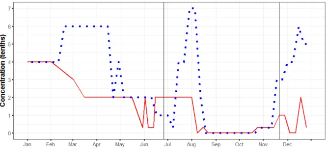
The presence of open water will positively influence transit times and fuel efficiency. However, it may pose additional risks such as, for example, interaction with icebergs, pieces of floating old ice, rough sea, and marine mammals. Figure 5 depicts a CASRAS analysis showing the presence of open water from 1997 through 2014 for the northern part of the route in question (west of 75°W from the entrance of Eclipse Sound to Milne Inlet).
The analysis shows that some portion of this route was ice-free during the typical shipping season but that the timing is subject to interannual variability.
Figure 5 Presence of Open Water west of 75°W (Eclipse Sound approach) based on minimum ice concentration less than 1/10. Vertical solid lines indicate the Zone 13 entry date and Zone 9 exit date shipping.
In the same manner, CASRAS can be used to assess the interannual variability of any ice condition. For example, the database may be queried for the historical presence of user-specified threshold ice concentration and ice type (e.g. 6 tenths of medium first-year ice, 70-120 cm thick)
4. Old Ice Hazards
The presence and concentration of old ice in shipping lanes needs to be considered for voyage planning. Type A vessels will not be allowed to operate outside the Zone Date System shipping window if the region is covered by high concentrations of old ice. In such cases, the Arctic Ice Regime Shipping System (AIRSS) must be used to determine whether a vessel can proceed. This topic is addressed in depth in Section 5. Figure 6 summarizes the maximum concentrations of old ice encountered along the Baffin Bay to Milne Inlet route in 2006 and 2014. These two years were chosen to compare conditions in a relatively light ice year (2006) and in a relatively heavy ice year (2014).
Figure 6. Maximum concentrations of old ice along the Milne Inlet route in years 2006 (relatively light ice year) and 2014 (relatively heavy ice year). Vertical solid lines indicate the Zone 13 entry date and Zone 9 exit date shipping.
The data summarized in Figure 6 suggest that the presence and concentration of old ice can vary considerably depending on annual conditions in the region. Furthermore, as is seen in late July and early August, old ice concentrations can be quite significant (greater than 6 tenths) along the Milne Inlet route during the regulated shipping season (i.e. the window of operation given by the Zone Date System). Note also that the presence of old ice in March and April of 2014 was significantly higher than in 2006. CASRAS has automated the process of manually compiling and interpreting the archived ice charts for this route. In addition to the concentration of old ice, the size of floes, frequency of old ice occurrence, thickness of different types of ice, ice concentrations, and other parameters can be extracted from the system for different legs of the route as well as for different windows of operation.
5. Ice Navigability
The CASRAS application can be used for evaluating the navigability through ice along the planned route while complying with Canadian regulations.
Arctic Ice Regime Shipping System (AIRSS)
In 1972, Transport Canada, in consultation with stakeholders, made extensive revisions to the Arctic regulations through the introduction of the Ice Regime System (ASPPR 1989; Canadian Gazette 1996; Equivalent Standards 1995; AIRSS 1996). The changes were designed to reduce the risk of structural damage in ships which could lead to the release of pollution into the environment, yet provide the necessary flexibility to ship-owners by making use of actual ice conditions, as seen by the Master, to determine the safest transit. AIRSS is based on a simple arithmetic calculation, producing an Ice Numeral (IN) that combines the ice regime and the vessel’s ability to navigate safely through that ice regime. The “Ice Regime” is a region of generally consistent ice conditions. The Ice Numeral is based
on the quantity of hazardous ice with respect to the ASPPR classification of the vessel. Further information about AIRSS and Ice Numeral calculation can be found in Timco and Johnston, 2003.
Polar Operational Limit Assessment Risk Indexing System (POLARIS)
IMO has developed a harmonized methodology for assessing operational limitations in ice called the Polar Operational Limit Assessment Risk Indexing System (POLARIS). This system combines concepts of the AIRSS system, the Russian Ice Certificate, and additional input from coastal administrations that have experience regulating marine traffic in ice conditions. POLARIS assesses ice conditions based on a Risk Index Outcome (RIO). A detailed description of POLARIS and RIO calculation can be found in the IMO Polar Code Advisory, 2016.
Both the AIRSS IN (Ice Numeral) and the POLARIS RIO (Risk Index Outcome) evaluate whether a vessel can safely proceed through the surrounding ice regime. If the values are positive, then a vessel is allowed to proceed; if the values are negative then she cannot. The main difference between the two systems is that AIRSS in the IN calculation considers severity of ice conditions and vessel characteristics, while POLARIS in the RIO calculation accounts for those parameters as well as vessel speed and escort requirements.
In this paper, the authors evaluated the ice navigability of a vessel comparing compliance to both AIRSS and POLARIS. The authors chose to evaluate two approximately equivalent vessel classes, Type A and PC6, that can navigate in the selected region within the June to November shipping season window defined by the Zone Date System. The paper also presents analysis for the entire year.
Ice Navigability for Vessel Type A and PC6
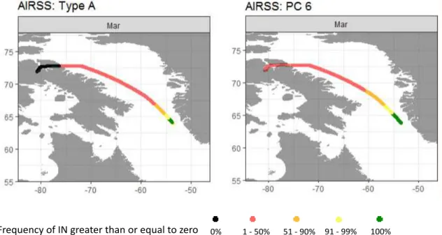
According to Transport Canada (TP 3231 – Ship Safety Bulletin No. 04/2009), an interim equivalent for the Polar Class 6 (PC6) vessel is the Type A vessel. Figure 7 presents the results of the AIRSS calculation of the Ice Numeral for both vessel classes. The month of analysis is March, which is well beyond the typical shipping window, to show the utility of the system in assessing year-round shipping operations. The results are presented as the frequency when navigation is permitted (a “Go” scenario). The calculation was based on Canadian Ice Service (CIS) digital ice charts from 2005 through 2014.
As shown in Figure 7, the navigability through Eclipse Sound (i.e. west of 75°W) would be restricted for a Type A vessel and not recommended for a PC6 vessel. This analysis suggests that the IN calculation for the Type A vessel results in a more conservative evaluation of ice navigability than for the PC6 vessel. This is an important result when considering the performance equivalencies of old (existing) and new (under design) vessels using the AIRSS approach. Closer evaluation of the navigability in the Eclipse Sound for the PC 6 vessel revealed that the frequency of IN > = 0 was in the range between 1 and 3%.
Ice Navigability for Vessel Type A under AIRSS and POLARIS
The CIS Eastern Arctic regional ice chart for March 14, 2016 has been used to calculate the Ice Numerals for the Type A vessel along the route, Figure 8a. The results show that on March 14, 2016 the Type A vessel would not be allowed to proceed through the region because the Ice Numerals values are less than 0.
In Figure 8b, the CASRAS application has been toggled to display the Polar Code equivalent of the Ice Numeral, the POLARIS RIO. Results show that the proposed POLARIS assessment provides more flexibility in operations for March 14, 2016, yet still requires heightened levels of precaution, including speed reductions and escort requirements for the approach to Eclipse Sound.
Other Applications of CASRAS for Voyage Planning
The previous analyses have touched on just a few applications of the environmental data and knowledge that constitutes CASRAS. Additional questions can be addressed using the CASRAS application, for example:
- Which Polar Class vessel is required to navigate year round to approach Milne Inlet? - What official nautical charts and other bathymetric surveys are available along the
route?
- What are the extreme wind conditions and air temperatures in Baffin Bay and Eclipse Sound over the last 30 years?
- Based on the last 30 years, what is the likelihood of having a window of operation of at least 48 hours of ice-free and calm-winds in the first two weeks of May?
- What information is available regarding marine hazards based on community local knowledge or experience from mariners on operating in Eclipse sound
Responding to these questions, however, is beyond the scope of this paper.
Frequency of IN greater than or equal to zero 0% 1 - 50% 51 - 90% 91 - 99% 100%
Figure 7. A comparison of the interim ‘equivalent’ vessel classes Type A and PC6 according
to the AIRSS navigability assessment. The frequency of Ice Numeral equal to or greater than zero (i.e. “Go” scenario) is computed for the month of March using data from 2005 through 2014.
Figure 8 a) Route navigability using the Arctic Ice Regime Shipping System (AIRSS) for a Type A vessel, according to the observed ice conditions on March 14, 2016. Red and orange zones are designated as not navigable by the Type A vessel.
Figure 8 b) Route navigability using the Polar Operational Limit Assessment Risk Indexing System (POLARIS) for a PC6 vessel, according to the observed ice conditions on March 14, 2016. Yellow and orange zone require limiting speed and escorting.
SUMMARY
NRC has developed the Canadian Arctic Shipping Risk Assessment System (CASRAS). It is an integrated risk assessment system for marine operations in the Canadian North that enables sound decision-making, which will lead to safer, more efficient shipping in this harsh environment. It provides a comprehensive framework for the storage, search and visualization of all key environmental data with specific application to shipping, icebreaking, and navigation in Northern waters and Arctic marine corridors. It is PC-based, easy to learn and use, and allows quick access to essential information at Northern latitudes where internet access is limited. It processes large datasets including georeferenced static and time-varying rasters, points, polygons, time-series, text, and digital media as part of a centralized workflow. It is a system in which data can be queried, visualized and extracted, various parameters can be evaluated, and reports can be generated, all for user-defined dates, times and regions of interest, and all on the fly. CASRAS can be used in the office and on-board a vessel. Information extracted from the system is useful for companies contemplating expanding to new regions, for selecting the type of vessel class to be used along the selected route, or for complying with the Polar Code. The system can also be used for determining the historical windows of safe shipping along a route, for evaluating impacts on Northern communities, for the planning of search and rescue operations and for extracting information documented by experienced mariners and Northerners. CASRAS provides a means for assisting in planning, navigation, and knowledge transfer, while improving transparency for the regulatory process. This paper presented an example of information extracted from CASRAS to assess conditions along the route to Milne Inlet from Baffin Bay. Two vessel classes were considered, Type A and PC6, when evaluating vessel certification based on low air temperature operations,
navigation through shipping safety control zones and sensitive marine areas, and ice conditions along the route.
ACKNOWLEDGEMENTS
The authors would like to acknowledge the National Research Council of Canada for funding this project. We thank Captain Mark Taylor for providing waypoints for the route, as well as Captains John Broderick, Terry Camsell, Dave Fowler and Ray Pierce for providing valuable information, comments and feedback throughout the system development.
REFERENCES
AIRSS 1996. Arctic Ice Regime Shipping System (AIRSS) Standards, Transport Canada, June 1996, TP 12259E, Ottawa. Ont., Canada.
ASPPR, 1989. Proposals for the Revision of the Arctic Shipping Pollution Prevention Regulations. Transport Canada Report TP 9981, Ottawa. Ont., Canada.
Canadian Gazette, 1996. Regulations Amending the Arctic Shipping Pollution Prevention
Regulations. p 1729, Ottawa, Ont., Canada.
Department of Fisheries and Oceans Canada, (2013). Report on Plans and Priorities 2013-14. Geoportal.gc.ca. (2017). Arctic Voyage Planning Guide. [online] Available at: http://geoportal.gc.ca/eng/Gallery/MapProfile/5 [Accessed 14 Feb. 2017].
Equivalent Standards for the Construction of the Arctic Class Ships, 1995. Transport Canada
Report TP-12260, Ottawa, Ont., Canada.
IMO Polar Code advisory, January 2016, ABS (American Bureau Shipping)
International Maritime Organization (2016) International Code for Ships Operating in Polar Waters (Polar Code) MEPC 68/21Add.1 Annex 10, viewed 14 September 2016,
http://www.imo.org/en/MediaCentre/HotTopics/polar/Documents/POLAR%20CODE%2
0TEXT%20AS%20ADOPTED.pdf.
Jacobi, M., Kinner, N.E., Braswell, B.H., Schwehr, K.D., Newman, K.S. and Merten, A.A., 2008, May. Environmental Response Management Application. International Oil Spill
Conference (Vol. 2008, No. 1, pp. 881-885). American Petroleum Institute.
Passages.ie.dal.ca. (2017). Passages Story Map. [online] Available at: http://passages.ie.dal.ca/Storymap/index.html [Accessed 14 Feb. 2017].
Polarview.aq. (2017). Polar View. [online] Available at: http://www.polarview.aq/ [Accessed 14 Feb. 2017].
Timco, G. and Johnston, M. Arctic Ice Regime Shipping System: Pictorial Guide, TP 14044E, January 2003
Transport Canada Ship Safety Bulleting, TP 3231, Bulletin No.: 04/2009; RDIMS No.: