HAL Id: hal-03188497
https://hal.archives-ouvertes.fr/hal-03188497
Submitted on 2 Apr 2021
HAL is a multi-disciplinary open access
archive for the deposit and dissemination of
sci-entific research documents, whether they are
pub-lished or not. The documents may come from
teaching and research institutions in France or
abroad, or from public or private research centers.
L’archive ouverte pluridisciplinaire HAL, est
destinée au dépôt et à la diffusion de documents
scientifiques de niveau recherche, publiés ou non,
émanant des établissements d’enseignement et de
recherche français ou étrangers, des laboratoires
publics ou privés.
Milton Boucard, Boris Marcaillou, Jean-Frederic Lebrun, Muriel Laurencin,
Frauke Klingelhoefer, Mireille Laigle, S. Lallemand, Laure Schenini, David
Graindorge, Jean-Jacques Cornee, et al.
To cite this version:
Milton Boucard, Boris Marcaillou, Jean-Frederic Lebrun, Muriel Laurencin, Frauke Klingelhoefer, et
al.. Paleogene V-Shaped Basins and Neogene Subsidence of the Northern Lesser Antilles Forearc.
Tectonics, American Geophysical Union (AGU), 2021, 40 (3), �10.1029/2020tc006524�. �hal-03188497�
1. Introduction
Worldwide, forearc trench-perpendicular basins are interpreted as the result of trench-parallel ex-tension possibly due to either strain partitioning as at the Aleutians (Ryan & Scholl, 1989) and Ryukyu (Nakamura, 2004) Subduction Zones, and/or to increasing margin curvature as at the Marianas (Heeszel et al., 2008) and Hellenic trenches (Angelier, 1978; Mascle & Martin, 1990). In more extreme cases, wide-spread deformation of forearc domains results from the collision of buoyant crustal features (e.g., oceanic plateaus, seamount chains, or continental fragments) which is prone to generate bending and rotation of subduction zones (e.g., Vogt et al., 1976). Strongly curved convergent plate boundaries are subject to along-strike variations in subduction obliquity and thus commonly associated with large-scale rigid body rotation
Abstract
Oblique collision of buoyant provinces against subduction zones frequently results in individualizing and rotating regional-scale blocks. In contrast, the collision of the Bahamas Bank against the Northeastern Caribbean Plate increased the margin convexity triggering forearc fragmentation into small-scale blocks. This deformation results in a prominent sequence of V-shaped basins that widens trenchward separated by elevated spurs, in the Northern Lesser Antilles (NLA, i.e., Guadeloupe to Virgin Island). In absence of deep structure imaging, various competing models were proposed to account for this Basins-and-Spurs System. However, high-resolution bathymetric and deep multichannel seismic data acquired during cruises ANTITHESIS 1-3, reveal a drastically different tectonic evolution of the NLA Forearc.During Eocene-Oligocene time, the Caribbean Northeastern Boundary accommodated the Bahamas Bank collision and the subsequent margin convex bending by major left-lateral strike-slip faults systems in the Greater Antilles and by trench-parallel extension along N40°–90°-trending normal faults in the NLA. Block rotations, forearc fracturing, and V-shaped valleys opening went along with this tectonic phase, which ends up with tectonic uplifts and an earliest-middle Miocene regional emersion phase. Post middle Miocene regional subsidence and tectonic extension in the forearc are partly accommodated along the newly imaged N300°-trending, 200-km-long normal Tintamarre Faults Zone. This drastic subsidence phase reveals vigorous margin basal erosion, which likely generated the synchronous westward migration of the volcanic arc. Thus, unlike widely accepted previous theoretical models, the NE-SW faulting and the prominent V-shaped valleys result from a past and sealed tectonic phase related to the margin bending and subsequent blocks rotation.
© 2021. American Geophysical Union. All Rights Reserved.
M. Boucard1,2 , B. Marcaillou2 , J.-F. Lebrun1 , M. Laurencin3 , F. Klingelhoefer4 , M. Laigle2, S. Lallemand5 , L. Schenini2, D. Graindorge3 , J.-J. Cornée1,5 , P. Münch5 , M. Philippon1 , and the ANTITHESIS and GARANTI Scientific Teams6,7,8,9,10,11,12,13,14
1Géosciences Montpellier, Université des Antilles, Université de Montpellier, CNRS, Campus de Fouillole,
Pointe-à-Pitre, Guadeloupe (FWI), France, 2Université Côte d’Azur, CNRS, IRD, Observatoire de la Côte d’Azur, Geoazur,
Valbonne, France, 3Laboratoire Géosciences Océan, CNRS-UBO-UBS, Université Bretagne Pays de Loire (UBL), Brest,
Institut Universitaire Européen de la Mer, Plouzané, France, 4Géosciences Marines, Ifremer, ZI de la Pointe de Diable,
Plouzané, France, 5Géosciences Montpellier, Université de Montpellier, CNRS, Université des Antilles, Montpellier,
France, 6Departamento de Ciencias de la Tierra, Fundacion Venezolana de Investigaciones Sismologicas (Funvisis),
Caracas, Venezuela, 7Université de Paris, Institut de physique du globe de Paris, CNRS, Paris, France, 8Université de
Lorraine, CNRS, CREGU, GeoResources Lab, Nancy School of Mines, Campus ARTEM, Nancy, France, 9Université
de Pau et des Pays de l’Adour, CNRS UMR 5212, Pau, France, 10Géosciences Montpellier, Université de la Guyane,
Université de Montpellier, CNRS, Campus de Cayenne, Guyane, France, 11Beicip-Franlab, Rueil-Malmaison, France, 12Department of Earth Science and Engineering, Imperial College London, London, UK, 13Laboratoire de Géologie de
Lyon: Terre, Planètes, Environnement, UMR CNRS 5276, Université Lyon 1, Lyon, France, 14Sorbonne Universités,
UPMC Université Paris 06, CNRS, Institut des Sciences de la Terre de Paris (ISTeP), Paris, France Key Points:
• The N. Lesser Antilles has undergone Eocene-Oligocene NW-SE extention and post mid Miocene NE-SW extension separated by a regional emersion
• Fault-bounded V-Shaped valleys result from past and sealed NW-SE extention due to Bahamas Bank collision, margin bending, and blocks rotation
• Drastic post mid Miocene subsidence and synchronous westward migration of the volcanic arc reveal vigorous subduction-related margin erosion
Supporting Information: • Supporting Information S1 Correspondence to: B. Marcaillou, boris.marcaillou@geoazur.unice.fr Citation:
Boucard, M., Marcaillou, B., Lebrun, J.-F., Laurencin, M., Klingelhoefer, F., Laigle, M., et al. (2021). Paleogene V-shaped basins and Neogene subsidence of the Northern Lesser Antilles forearc. Tectonics, 40, e2020TC006524. https://doi. org/10.1029/2020TC006524
Received 16 SEP 2020 Accepted 25 JAN 2021
of forearc microplates (McCabe, 1984). A compilation of plate convergent boundaries supports this rela-tionship between lateral change from subduction to collision, plate boundary bending, and forearc rotation (Wallace et al., 2009). These authors suggested that the indentor apply a torque force on the upper plate due to continuous subduction away from the indentor depending on the ability of the slab to roll back. Thus, most of the time, the collision triggers rotation of large-scale forearc blocks, sometimes large enough to be named “microplate.” In this context, various parameters control the trench motion velocity, the slab roll-back or anchoring, and the plate drag resulting in varying convexity for the subduction zones worldwide. These parameters include mantle rheology and toroidal flow at slab edges, slab-mantle rheology contrast, along-strike variations in slab age and density, along-strike variations in interplate friction (Schellart, 2010). Margin bending and block rotations define an upper plate deformation pattern, possibly including backarc basin spreading (Boutelier & Cruden, 2013; Wallace et al., 2009) trench-parallel strike-slip fault and forearc stretching that depend on the amount of trench bending (Heeszel et al., 2008).
At the Northern Lesser Antilles (NLA) Margin, a prominent V-shaped Basins-and Spurs System extends along the inner forearc from La Désirade Island to Anguilla Island (Figures 1 and 2). This system consists in a regional sequence of transverse V-shaped valleys opening trenchward, bounded by N40 –90°-trending scarps and separated by 4–6-km high spurs. No consensus has been reached about the age and the causes for this tectonic pattern. Previous studies suggested that northward increasing strain partitioning, due to the curved shape of the subduction zone, caused along-strike stretching within a northwestward-moving forearc sliver (Lopez et al., 2006) bounded westward by a left-lateral strike-slip fault along the volcanic active arc (Feuillet et al., 2002, 2011). According to this model, forearc stretching triggers the currently ac-tive N40 –90°-trending normal faults, which control vertical relaac-tive motion at the V-shaped basins flanks. This model implies long-term strong mechanical coupling along the interplate contact of a curved margin, which is somewhat controversial with the lack of crustal-scale transcurrent tectonic systems south of the Anegada Passage (Laurencin et al., 2019). Other studies suggest that, since the late Paleocene–early Eocene time, the collision and westward drifting of the Bahamas Bank with the Northeastern Caribbean Plate has likely caused the current margin convexity (Pindell & Barrett, 1990) (Figure 1), the margin segmentation in regional-scale crustal blocks (e.g., Pindell & Kennan, 2009) and blocks rotations (e.g., Mann et al., 2005). In this study, we raise the question of the relationship between the widespread, pervasive and deep-rooting fracturing of the NLA Forearc V-shaped Basins-and-Spurs System, and the convex margin bending. Ab-sence of detailed bathymetric data and deep seismic images across the Basins-and-Spurs System previously precluded detailed investigations of the NLA Forearc deformation chronology. As a result, chronology and causal relationships between continental collision, margin bending, increasing convergence obliquity, and forearc fragmentation in transverse (perpendicular to the trench) basins need to be evaluated.
During SISMANTILLES 1 (Hirn, 2001), SISMANTILLES 2 (Laigle et al., 2007), ANTITHESIS 1 (Marcaillou & Klingelhoefer, 2013a, 2013b), and ANTITHESIS 3 (Marcaillou & Klingelhoefer, 2016) cruises onboard French R/Vs Nadir, L’Atalante, and Pourquoi Pas? we recorded high resolution bathymetric, low frequency multi-channel seismic (MCS) and wide-angle seismic (WAS) data in order to decipher the tectonic defor-mation at the NLA Margin. In this study, we focus onto the margin tectonic evolution that resulted in the V-shaped Basins-and-Spurs System, which dissects the NLA Forearc. We describe the sedimentary archi-tecture and tectonic deformation of the northernmost features of this system. The newly imaged Saint-Bar-thelemy Valley and bordering Tintamarre and Barbuda Spurs (Figure 3) highlight the tectono-stratigraphic evolution of the area. Correlating our seismic interpretation to onshore geological constraints and up-per-margin basins stratigraphy (Cornée et al., 2020; De Min et al., 2015; Legendre et al., 2018) allows us to propose a chronostratigraphic interpretation of the tectonic evolution of the studied area. As a result, this study revises fundamentally the formation and tectonic evolution of the V-shaped Basins-and-Spurs System in the frame of a bending convergent margin.
2. Geological Settings
The Lesser Antilles Subduction Zone is located at the eastern edge of the Caribbean Plate where the North and South American Plates subduct westward at ∼20 Km/Myr in a ∼N254° direction beneath the Lesser Antilles Margin (DeMets et al., 2000) (Figure 1). The margin convex shape generates a northward increase
in plate convergence obliquity, from ∼0° offshore of Guadeloupe to more than 70° offshore of Puerto-Rico. Since the early Eocene, relative plates motion has remained mostly constant and absolute motion of the Caribbean Plate is nearly stationary in a mantle reference frame (Müller et al., 1999). Thus, the North Amer-ican Plate has moved westward, leading the Bahamas Bank to sweep along the northern Caribbean Plate Margin. This Bahamas Bank is a continental and oceanic buoyant plateau covered with is a ∼20,000 km2 NW-SE-trending massive shallow water carbonate platform and prograding sediments. Since the late Pale-ocene–early Eocene time, the collision of the bank with the Greater Caribbean Arc has resulted in a major plate boundary reorganization (e.g., Pindell & Barrett, 1990; Pindell et al., 1988). The plate boundary relo-cated along the left lateral Cayman Trough that propagated from west to east, to transpressive fault zones across Hispaniola and possibly to the left-lateral strike-slip Anegada Passage (Leroy et al., 2000; Pindell & Barrett, 1990; Pindell et al., 1988).
The NLA Subduction Zone has generated three distinct volcanic arcs: (1) the late Cretaceous–Paleocene arc at the Aves Ridge (Bouysse et al., 1985; Neill et al., 2011), (2) the remnant middle Eocene–earliest Miocene Lesser Antilles Arc in the current forearc to the north of Martinique Island (Bouysse & Westercamp, 1990; Legendre et al., 2018; Martin-Kaye, 1969), and (3) the early Pliocene–present day Lesser Antilles active Arc, located to the west of the previous arc (Lindsay et al., 2005) (Figure 1). The NLA Forearc basins de-veloped, at least partly, during the post early Miocene landward migration of the volcanic Lesser Antilles
Figure 1. Regional bathymetric map of the Northern Lesser Antilles Subduction Zone (GEBCO 2014 data set—WGS84–UTM20). Plates: Caribbean (CAR),
North American (NA). Margin segments: Puerto Rico Virgin Islands (PRVI), Northern Lesser Antilles (NLA). Trenches: Lesser Antilles Trench (LAT), Muertos Trough (MT), Puerto Rico Trench (PRT). Islands and plateaus: Antigua (A), Anguilla (An), Barbuda (B), La Désirade (D), Dominica (Do), Guadeloupe (G), Martinique (M), Marie-Galante (MG), Saba Bank (SB), Saint Barthelemy (SB), Saint Martin (StM), Virgin Island (Vi). V-shaped valleys: Anguilla Valley (1), Saint-Barthelemy Valley (2), Barbuda Valley (3), Antigua Valley (4), Meduse Basin (5), La Désirade Valley (6). Spurs: Maliana Spur (a), Tintamarre Spur (b), North and South Barbuda Spurs (c), Man of War Spur (d), Bertrand (South) and Falmouth (North) Spurs (e), Karukéra Spur (f); KB: Kalinago Basin; SB2: Petroleum drill Saba 2. Red line: remnant volcanic arc (middle Eocene–early Miocene). Green line: active arc (Pliocene to Present day). Black arrows: relative plates motion. Yellow and red frames: indicate location of Figures 2 and 3, respectively.
Arc recording the tectonic evolution for this period. Bouysse and Wester-camp (1990) suggested that this arc migration resulted from a slab shal-lowing subsequent to a slab rupture after the Bahamas Bank collision. Alternatively, Allen et al. (2019) proposed that the slab has shallowed underneath the Lesser Antilles in response to constraints imposed by the neighboring American Plates.
The reduced size of the ∼30-km-wide accretionary wedge (Figure 2) that fronts the NLA Forearc, contrasts with the >100-km-wide prism off-shore of Guadeloupe and farther south (Deville & Mascle, 2012; West-brook et al., 1984). This accretionary prism thus narrows northward as the South American continental sources of sediments recedes (Deville et al., 2015). The outer forearc domain corresponds with an interpreted transition zone made of imbricated and underplated material or damaged upper plate igneous basement covered with deep forearc sedimentary ba-sins (Bangs et al., 2003; Evain et al., 2013; Laigle et al., 2013) (Figure 2). To the northwest of Barbuda Island, the trench-parallel left-lateral strike-slip Bunce Fault separates the accretionary wedge from the outer forearc (Laurencin et al., 2019) (Figures 1 and 2). This fault accommodated the left-lateral component of the plate convergence, revealing active strain partitioning along the oblique plate boundary to the northwest of Bar-buda (Laurencin et al., 2019; ten Brink & Lin, 2004). Farther west, at the Puerto Rico and the Virgin Islands (PRVI) Margin, the Bunce and Bow-in left-lateral strike-slip faults connect to the northern Hispaniola litho-spheric transpressive faults, which bound the Bahamas Bank–Hispaniola collisional system (Mann et al., 2005; Rodríguez-Zurrunero et al., 2019; ten Brink & Lin, 2004).
The boundary between the inner and the outer forearc is located at the margin slope break at the easternmost extent of the V-shaped Basins-and-Spurs System (Figure 2). Upslope, the inner forearc alternates rem-nant volcanic arc islands (Antigua, St Barthelemy, St Martin) and Neo-gene to Pleistocene carbonate platform, some of which being emerged (Marie-Galante, Eastern Guadeloupe, and Anguilla) (Budd et al., 1995; Cornée et al., 2012; Münch et al., 2013). Perched turbiditic basins sur-round these reliefs (Bouysse & Mascle, 1994; De Min et al., 2015). North of Guadeloupe, the trench-parallel Kalinago Basin separates the remnant arc islands from the present-day volcanic arc. Along the latter, a series of arc-parallel, en-échelon, deep basins is interpreted as right-stepping transtensive relays for an incipient strike-slip structure possibly related to strain partitioning (Feuillet et al., 2002, 2011; Laurencin et al., 2019). However, evidences of their sedimentary architecture and tectonic defor-mation are lacking and impede to progress on the understanding of their origin and evolution along with the margin bending.
3. Data Acquisition and Processing
3.1. Multi-Channel Seismic
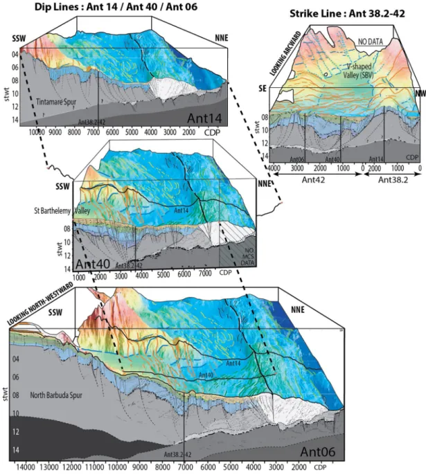
We present five of the 54 MCS lines acquired along the northernmost features of the NLA V-shaped Basins-and-Spurs System located offshore St Barthelemy and Barbuda islands. Three dip lines (Ant06, 14, 40) and two strike lines (Ant38.2, 42) were recorded during cruises ANTITHESIS 1 and 3. MCS acquisition parameters are sum-marized in Table 1. Along MCS line Ant06, Wide Angle Seismic data were also recorded (Laurencin et al., 2018). Data pre-processing (Quality control and 12.5 m binning) was performed onboard using QCSispeed® and Solid-QC® software’s (Ifremer), while the post-cruise processing sequence, with Geovation® (CGG), includes:
Figure 2. Relief slope map, with angle value ranging from 0° to
20°, calculated from the GEBCO 2014 and ANTITHESIS data set. Abbreviations: V. for valley, S. for Spur, B. for basin, R. for ridge. See yellow frame in Figure 1 for location.
• Additional gain function of time to correct the spherical divergence • Two phases of high amplitude and low frequency noise attenuation • External mute on shot point to remove direct and refracted waves • Iterative stacking-velocity analysis: 1 on stacked sections and 3 on
Common Middle Point
• Normal move-out (NMO) using the final velocity law • External mute after NMO to reduce far offset stretching
• Multiple attenuation with 2D-SRME method (Adaptive Sur-face-Related Multiple Elimination: Multiple modeling and adap-tive subtraction of the multiple model from data [Verschuur et al., 1992])
• Predictive deconvolution to improve data resolution
• Internal mute on gathered CMP to remove the short offsets of resid-ual multiples
• Second phase of multiple attenuation in Radon domain
• Stack with a time variant Band-Pass filter (3,5,70,80 Hz from 0 to 6 s and 3,5,35,45 Hz from 8 to 15 s)
• Post-stack (f,k) migration at constant velocity (1,500 m/s) and BP fil-ter (3,5,70,80 Hz)
Figure 3. (a) Detail bathymetric map with morphostructural interpretation for the St Barthelemy Valley (SBV), Tintamarre and south Barbuda Spurs at
the Northern Lesser Antilles Margin. (b) Tectonic map for the same area. From south to north, red, orange and yellow lines show N340°, N300°, and N280°-trending faults. Blue lines show N20 –50°- and N60 –90°-N280°-trending faults that bound the V-shaped basins. See red frame in Figure 1 for location.
Seismic line Ant06 Ant14 Ant38,2 Ant40 Ant42
Survey Antithesis I Antithesis III
Airgun array (in^3) 7699 6500
Shot interval (s) 60 60 Shot spacing (m) 154 150 Shot number 189 605 523 Record time (s) 25 20 Traces number 300 288 720 Data sampling (ms) 2 2 Traces spacing (m) 12.5 6.25 Fold coverage 12 54 56 56 Acquisition speed (Kn) 5 5 Table 1
3.2. Multibeam Swath Bathymetry
We acquired bathymetric data with a Kronsberg EM-122 and a Reson Seabat 7150 multibeam echosound-ers onboard R/V L’Atalante and R/V Pourquoi Pas? respectively. We complemented the data set with other French cruises multibeam data including SISMANTILLES 2 (Laigle et al., 2007), KASHALLOW 2 (Leb-run, 2009), and AGUADOMAR (Deplus, 1998) cruises. Multibeam spatial resolution depends on aperture and number of beams of the echosounders, shooting rate, and ship speed (5 kt during MCS acquisition or 10 kt) and thus varies greatly with depth. Given the wide range of depth in our area, we produce sounding density maps to determine an optimal DTM grid spacing at 75 m. This ensures sufficient sounding aver-aging for each DTM cell (min. ca. five sounds) and allows reducing the interpolation down to two rows, to ensure a total coverage even in areas of great depth. Vertical resolution is also depth dependent and ranges from a few decimeters at shallow depth to tens of meters at great depth. Data processing, performed with Caraïbes® and Globe® software, consists in removing aberrant probes, near neighbor DTM gridding and fil-tering. We generated color-coded high-resolution bathymetric slope maps (Figure 2) using QGis® software in order to interpret morpho-structures that outcrop at the seafloor.
4. Results
This new bathymetric and seismic data set, in a previously poorly investigated area allows us to decipher for the first time the chronology of the tectono-stratigraphic evolution of the Saint-Barthelemy Valley and bordering Spurs (Figure 3) in the wider frame of the V-shaped Basins-and Spurs System of the NLA Forearc.
4.1. Morpho-Structure of the NLA Margin
At the NLA Subduction Zone, to the east of the deformation front, numerous seamounts, bending faults and elongated ridges of the oceanic fabric along with a very thin sedimentary fill roughen the seafloor of the up-to-8,000-m-deep subducting plate (Figures 1 and 3a). To the west, a ∼30-km-wide accretionary wedge (yel-low zone in Figure 3b) with a classical morphology of an eroding in-sequence fold and thrust belt extends to the Bunce Fault (Laurencin, 2017). The outer forearc (white zone in Figure 3b) extends from the Bunce Fault to the slope break and consists in >4,500-m-deep flat basins to the northwest of 18.6°N and 61.8°W (dotted pattern in Figure 3b) and in a more elevated seafloor showing N320 –350°-trending sigmoid linea-ments, to the southeast. The inner forearc (gray zone in Figure 3b) shows a north-south sequence of basins and spurs from the Anegada Passage to the Karukera Spur (Figure 2). N70°–N90°- and N20°–N50°-trending linear scarps structure the southern and northern flanks of the basins, respectively, resulting in their V shape (blue lines in Figure 3b). The southeastern flank is usually steeper suggesting that these asymmetric basins are mainly controlled by northwestward-dipping faults. These V-shaped basins narrow and termi-nate eastward of the remnant arc islands that stand in the NLA Forearc. The smooth basin floors gently dip trenchward, contrasting with the rough spurs seafloor and the outer forearc topography (Figure 2). To the south, the subducting and southward sweeping Barracuda Ridge deforms the accretionary wedge, the outer forearc, and the trenchward part of the V-shaped basins (Figure 2). For instance, La Désirade Basin gently dips and opens toward the outer forearc to the south of the deformed area, while uplifted and inverted basins front La Méduse Basin located above the subducting ridge. At the open side of La Désirade Basin, fault-bounded basement highs and associated linear N50°–60°-trending bathymetric ridges extend from the Bertrand and Falmouth Spurs (Figure 2) (see seismic line SL3, Figure 3 in Laigle et al., 2013). To the north, the outer slope of the Antigua, Barbuda, St Barthelemy, and Anguilla Valleys is steep and trun-cated by trench-parallel escarpment. The seafloor morphology and deep seismic images recorded in and around the St Barthelemy Basin provides evidences about the geological evolution of these V-Shaped basins.
4.2. Morpho-Structure of the St Barthelemy Valley and Surrounding Spurs
The up-to-70-km-wide V-shaped St Barthelemy Valley separates the >80-km-long, >20-km-wide NE-SW-trending Tintamarre Spur to the north from ∼60-km-wide Barbuda Spur to the south (Figure 3). The spurs crest climaxes 3,600–4,000 m above the 3,500–5,700m-deep and 1.5°-trenchward-dipping smooth seafloor of
the St Barthelemy Valley. Some canyons, running from the carbonate platform (Figure 3a) to small deltaic mass-deposits, incise the spurs flanks (Figure 3). From south to north, three sets of trench-facing escarp-ments, up-to-100-m-high (red, orange and yellow in Figure 3b) define a ∼1,000-m-high drop toward the out-er forearc. First, in the Antigua Basin (Figure 3a) immediately north of the subducting Barracuda Ridge, the escarpments trend N340° (red in Figure 3b). Second, northward, N300°-trending escarpments (orange in Figure 3b), extend along a 30-to-40-km-wide zone which spreads from the outer forearc in the east through the Saint Barthelemy and Anguilla Valleys, and the Barbuda and Tintamarre Spurs. Third, to the north, at the Anguilla Valley (Figure 3a), N280°-trending escarpment (yellow in Figure 3b) truncate the N300°-trend-ing escarpments. This latter escarpment set extends from the outer forearc to the Sombrero Basin (Figure 2), sub-parallel to the left-lateral strikes-slip Maliwana-Sombrero System (Laurencin et al., 2017) (Figure 3). These three sets of trench-facing escarpments truncate and locally vertically offset the scarps that bound the spurs and the basins without systematically offsetting them laterally. They are directed N340°, N300°, and N280° from south to north, indicating a 60° counterclockwise rotation of the forearc fracturing, which is consistent with an accommodation of the trench-parallel increase of the margin convex geometry.
4.3. Tectonic and Stratigraphic Architecture of the NLA Margin
In the following section, we decipher the stratigraphic architecture and tectonic features along the St Bar-thelemy Valley, the N-Barbuda and Tintamarre Spurs, based on dip MCS lines Ant06, 14, 40 and on strike MCS line Ant38.2, 42 (Supplementary Material and Figure 4). We combine these descriptions with pub-lished studies (De Min, 2015 #498; Laurencin, 2018 #2509), in order to discuss the chronology of the major fault systems in the NLA.
4.3.1. The Subducting Plate
The subducting oceanic crust shows faint and irregular reflectors floored by series of short irregular low frequency reflectors at Moho depth, derived from wide-angle model along line An06 (Klingelhoefer, 2018
#2774; Laurencin, 2018 #2509). The strong amplitude low frequency reflectors at the top of the oceanic crust in the trench progressively faint beneath the outer forearc and vanish beneath the tip of the inner forearc. Subducting horsts and grabens roughen the top of the crust consistently with the seafloor morphol-ogy to the east of the trench. The decollement corresponds with irregular, average amplitude, low frequency reflectors with locally reverse polarity. The top of the oceanic crust and the decollement encompass low amplitude sub-parallel reflectors in the subduction channel revealing a thin section of preserved poorly deformed subducting sediments, mainly located in the grabens (Figure 4 and Supplementary Material).
4.3.2. The Upper Plate Basement
Wide-angle model Ant06 shows that the Moho of the upper plate dips landward from 23 to 28 km depth (Klingelhoefer et al., 2018; Laurencin et al., 2018). At this depth, low amplitude, low frequency, discon-tinuous reflectors rise slowly from 13 stwt at CDP 7750 to 10 stwt at CDP 14000 because of a pull up effect (Supplementary Material and Figure 4). Line Ant40, shows similar reflections from 13 to 12 stwt at CDP 500–3000. Upward, the poorly reflective basement shows locally low frequency, low amplitude, and irregular to chaotic reflectors. Vertical velocity gradient in the basement, derived from wide-angle data, is characteristic of an arc igneous crust (Klingelhoefer et al., 2018; Laurencin et al., 2018). Strong amplitude and low frequency series of reflectors, UB0, separate the basement from the overlying strati-fied sedimentary units.
Average amplitude and frequency, sub-parallel, and rather continuous landward dipping reflectors define a wedge-shaped unit beneath the outer forearc, immediately west of the Bunce Fault, at CDP 3700–6000 in line Ant06 and at CDP 7000–5500 in line Ant40. This unit rests above the decollement and beneath the margin basement. Above this wedge, the top of the margin basement UB0 turns from trenchward dipping to landward dipping. This wedge-shaped unit does not exist along the line Ant14 (Supplementary Material and Figure 4) and the margin basement topography continuously dips trenchward while the basement crust thins. Similar structure is also described offshore of the Karukera Spur beneath the outer forearc (Bangs et al., 2003; Evain, 2013 #579; Laigle et al., 2013). The transpressive positive flower structure of the Bunce Fault bounds the margin basement trenchward (Laurencin et al., 2019). To the east, series of arcward
dip-ping, continuous and high frequency reflectors indicate, and imbricated structure of in-sequence thrusts within an accretionary prism.
4.3.3. The Margin Slope Basins Stratigraphy
Based on sismo-stratigraphic description, we define four sedimentary units, U1 to U4, above the basement unconformity, UB0, separated by three unit boundaries, UB1 to UB3. The most complete sequence is pre-served in the St Barthelemy Valley as revealed by lines Ant40 and Ant38.2–42 (Supplementary Material and Figure 4).
At the bottom of the St Barthelemy Valley, deep reflectors of unit U1 lap onto UB0 toward the arc and the spur flanks. UB1 conformably tops U1 albeit local truncations in the thickest and faulted part of the basin.
Figure 4. Three-dimensional seismic bathymetry view for lines Ant14, 40, 06, 38.2, and 42 (see solid orange lines in Figure 3 for location). Seismic line interpretation details and un-interpreted data are in supplementary material.
Onlaps of unit U2 reflectors onto UB1 help with identifying this unconformity. U1 reflectors are low-fre-quency, low-amplitude, layered, and continuous upslope and more discontinuous and poorly layered in the basin. U1 is up-to-1stwt-thick in contact with the basin bounding faults (Ant40 CDP 2750–3500; Ant42 CDP 200–2000) and thins above buried horsts (Ant42 CDP 500–1000).
In the St Barthelemy Valley, trenchward-dipping unit U2 rests unconformably above UB1, retrograding landward with onlaps above UB0 over the spurs and the upper margin plateau. Strike line Ant38.2–42 shows that U2 reflectors downlap onto UB1 in the valley, indicating a progradation from the spurs to the basin centers. Strong amplitude reflector UB2 tops U2 with numerous reflector truncations, which classi-cally indicate erosional surfaces. U2 shows average amplitude, average frequency, layered discontinuous to irregular reflectors upslope and lower amplitude, higher frequency, and more chaotic reflectors above the outer forearc. Over the spurs, U2 is 1–1.5-stwt-thick with local variations controlled by incisions and fan-shaped deposits at fault bounded basins (at CDP 9000–10000 in line Ant06 for instance). U2 thickens up to ∼2.5 stwt in the eastern part of the St Barthelemy Valley (CDP 1875 in line Ant38.2–42). The steeply dipping and downlaping reflectors of U2 result in an overall fan shape located near faults that dip from the Tintamarre Spur toward the basin.
Unit U3 is located over the uppermost plateau, the Barbuda Spur slope (Ant06) the St Barthelemy and Bar-buda Valleys (Ant38.2–42) but is absent over the outer forearc and the Tintamarre Spur (Ant14). Deep U3 reflectors lap onto UB2 at the upper plateau. In contrast, in the valley, these reflectors show downlaps onto
UB2 in the dip direction and onlaps in the strike direction revealing a trenchward prograding unit. UB3 tops U3, mostly conformably at the plateau but truncating uppermost reflectors in the St Barthelemy and
Barbu-da Valleys. The high frequency and average amplitude reflectors of U3 are layered and continuous over the plateau and more irregular in the valleys. This unit thickens from the plateau to the valley, up to 0.9-stwt at the valley center (Ant40 CDP 3250, Ant42 CDP 1200) forming fan shapes at southeast dipping faults. Unit U4 is up-to-0.4-stwt-thick in local narrow residual basins along the upper slope plateau (Ant06 CDP 12000–14600) and in the deep outer forearc basin (Ant14 CDP 4000–6200) where it rests unconformably upon UB2. Deep reflectors of U4 downlap trenchward onto UB2 at the outer forearc (Ant06 and Ant40) and onlap onto UB3, landward into the valleys. U4 reflectors are irregular and poorly layered over the outer forearc and more continuous upslope with high frequency and average amplitude. U4 shows fan-shaped deposits, perpendicular to the basin axis (line Ant38.2–42) that progressively infill the valleys retrograding onto the basin border faults.
4.3.4. Tectonic Deformation in the Basins-and-Spurs System
Based on bathymetric morphostructures and deep seismic images, we identified two main sets of faults. N40 –90°-trending faults bound the V-shaped basins, dipping toward the basin axis (blue lines in map Fig-ure 3b and in strike lines Ant38.2–42, Figure 4). The N300° trending Tintamarre Faults Zone (Orange line-aments in Figure 3 and dip lines Ant06, Ant40, and Ant14, Figure 4) crosscuts the basins and the spurs. In the following, we demonstrate that Tintamarre Faults activity postdates that of the spurs-bounding faults. The St Barthelemy Valley is an asymmetric graben between two spurs. At the basin northern flank, in the hanging wall, the basement is downwardly offset by southeastward-dipping listric normal faults (planes A, B, C at CDP 2000–2300 in line Ant38.2 and CDP 900 in line Ant42—Supplementary material and Figure 4).
U1 and U2 show fan shape in the basin associated to these faults. At the southern bound of the basin,
steep-er northwestward-dipping normal fault planes D, E (line Ant38.2–42 CDP 2250–2900) also dip toward the basin axis. Most of these normal and listric faults are deeply rooted in the crust. This crustal-scale fracturing shifts downward the basement top, UB0, by 4.5-stwt, from 7 stwt at the Tintamarre Spur crest, to 11,5 stwt at the deepest point in St Barthelemy Valley (line Ant38.2–42). Considering P-waves velocity of 1,500 m/s in the water and ∼2,500 m/s in the sediments, the vertical drowning of the basin floor is up to ∼5,000 m. At last, tectonic restoration allows estimating the amount of extension across the mouth of the V-shaped basin to be ∼20%, which is consistent with the bulk crustal extension estimates provided by Legendre et al. (2018).
U1, restricted to the St Barthelemy Valley, is thicker in the grabens than over the horsts revealing a
syntec-tonic deposit during opening of the V-shaped basin. The drastic increase in sediment thickness in the valley is mainly accommodated by U2 thickening. This thickening associated to fan-shaped reflectors series dip-ping and prograding toward the basin axis are likely to be related to N40°–90°-trending faults activity. U3 is
mostly horizontal showing locally smaller fan shapes against the valleys bounding faults. Some of these faults seal into U2 (at CDP 1500 in line Ant-40 for instance), while others remain active up to U3 (at CDP 1000 in line Ant38.2–42) and seal before U4. Thus, tectonic activity at the N40°– 90° valley-bounding faults initiated during U1, climaxed during U2, and has progressively ceased during early deposits of U3 (Figure 5). Any pres-ent-day activity for these faults is uncertain and/or of second order as revealed by the systematic offset of the surface traces of the N40°–90° faults by the N300° faults in map view (Figure 3).
The N300°-trending, up-to-100m-high scarps across the V-shaped Basins-and-Spurs System correspond at depth with steep trenchward-dipping normal faults. This Tintamarre Faults Zone controls landward tilted ba-sins and trenchward drowned crustal blocs in their hanging walls. These faults offset the seafloor and affect the thickness of recent sedimentary units U3 and U4 indicating a recent syn-sedimentary tectonic activity. These faults are deeply rooted, possibly down to the interplate contact (at CDP 3000–4000 in line Ant40 and CDP 7000–7500 in line Ant06) or down to intracrustal layered reflectors (∼12-stwt-dip in line Ant40 CDP 2000–2500 and ∼10-stwt in line Ant06 CDP 8500–10000) the Moho being substantiated at >13-stwt-depth based on WAS data. Although decipher-ing the faultdecipher-ing initiation is hazardous, the N300° faults systematically offsets the N40°–90° faults indicating that Tintamarre Faults activity postdates that of the spurs-bounding faults (Figure 5).
We conclude that two main sets of faults, successively active through time, deform the NLA inner forearc domain (Figure 5). First, a N130°– 160° directed (trench-parallel) extension controlled the V-Shape fractur-ing of the basins durfractur-ing U1 and U2 deposition. Then, a N10°–30° directed (trench-perpendicular) extension generated normal faulting sub-parallel to the trench during U3 and U4 deposition. This latter fault system ac-commodates the regional forearc subsidence and basement thinning.
5. Tectonic Evolution of the NLA Forearc
As discussed in the following, we interpret two successive extensive tectonic phases in the NLA Forearc sep-arated by a regional emersion, the UB2 unconformity. Prior to the emersion phase, trench-parallel extension triggered crustal normal faulting that opened the transverse V-Shaped valleys. Since UB2, trench-perpendic-ular extension generated ∼50-km-wide, >300-km-long N300°-trending Tintamarre Faults Zone associated with basement thinning and long-lasting margin subsidence.
5.1. Regional Emersion Phases
The widespread unconformity, UB2, separates deep deformed, tilted sedimentary units thickening toward the basin axis with local syn-tectonic features, from overlying units of less deformed reflectors draping un-conformably at low angle over UB2. This unconformity shows widespread high-angle truncations on top of
U2 and incisions, from the outer forearc to the upper slope, which indicate a regional erosion surface during
a subaerial to shallow water phase. This large-scale uplift and emersion phase indicates a major tectonic rearrangement before a drowning to great depth. Stratigraphic correlations, discussed in the following, sug-gest an earliest middle Miocene age for UB2.
To the west, at the Saba Bank, two unconformities are observed in SB2 well, Oil company MCS lines (Church & Allison, 2004), and lines GA15B-C-GA08 (Figure 6) recorded during the GARANTI cruise (Cornée et al., 2019; Lebrun & Lallemand, 2017; Philippon, Cornée, et al., 2020; Philippon, van Hins-bergen, et al., 2020 #2812). From Church and Allison (2004), a late Eocene unconformity S3 sep-arates an undrilled basement unit topped by middle Priabonian andesitic lavas flows overlaid by a
Figure 5. Stratigraphic log for the main unit facies and the main tectonic
phases of fault systems at the St Barthelemy Valley and the Tintamarre and Barbuda Spurs. S5 is from Church and Allison (2004).
very late Eocene to early Oligocene Lower Carbonate and Turbiditic unit. The latter is topped by an erosional unconformity S4, overlaid by a late Oligocene to early Miocene Fluvial deltaic unit. An ero-sional unconformity S5 dating to the earliest middle Miocene tops this latter. S5 extends eastward along a hundred of kilometers from the Saba Bank to the Anguilla Bank through the Kalinago Basin (Bouysse, 1994 #2754; Cornée et al., 2019). These features indicate shallow waters and emersion phas-es, except in the deepest parts of the Kalinago Basin. Onshore the Anguilla Bank an earliest middle Mi-ocene erosional unconformity and sediment hiatus in Saint Martin Island correlates laterally to an ero-sional unconformity overlain by an early Langhian Megabreccia in nearby Tintamarre Islet (Andreieff et al., 1988; Cornée et al., 2019). In other nearby islets, between St Martin and St Barthélemy (Roche Boeuf, Roche Table), some meters of shallow water carbonates date to latest Burdigalian-earliest Lang-hian (Andreieff et al., 1988) and in Anguilla, middle Miocene deposits are represented by a few meters thick condensed shallow water coral banks (Cornée et al., 2019). Thus, these earliest middle Miocene
Figure 6. Synthetic cross section from the trench (A) to the backarc (B) based on seismic lines recorded during cruises ANTITHESIS (ANT40–ANT06) and
GARANTI (GA15–GA08). Stratigraphic correlation is obtained from nearby drill SB2 to GA15 and extended to the forearc. S3 and S5 are from Church and Allison (2004). See text for explanation.
unconformity and shallow water deposits are of regional extent. Farther south, at the latitude of Gua-deloupe Island, Bouysse and Mascle (1994) and Bouysse and Westercamp (1988) interpreted an early Miocene unconformity between deep complex sedimentary sequences and an onlapping sedimentary cover. These features suggest that the margin has been subsiding trenchward by more than 2,500 m since the middle Miocene. Consistently, at the Karukera Spur, a prominent unconformity tops a dated early Miocene shallow water carbonate platform subsequently subsided and tilted trenchward leading to basinal environment deposit during the middle Miocene (De Min et al., 2015). Consequently, our subaerial erosional unconformity UB2 likely corresponds to the earliest middle Miocene unconformity extending over the NLA Forearc, from the Anguilla Bank to the Karukera Spur and to the backarc, below late middle Miocene to Pliocene deposits. This unconformity indicates a regional-scale transient earliest middle Miocene emersion phase in the NLA Forearc, possibly slightly diachronous north to south from our study area to the latitude of Guadeloupe Island.
A lower boundary age for U1 can be proposed. At St Barthélemy and in the backarc, compressional tec-tonic structures are sealed by a late Priabonian unconformity (Church & Allison, 2004; Philippon, Cornée, et al., 2020). Following this compression, the Kalinago Basin opening and extensive evidences in the North-ern Anguilla Bank attest for a regional extension during the early Oligocene to early Miocene characterized by synsedimentary half-grabens (Cornée et al., 2019; Legendre et al., 2018). Syntectonic deposits of Unit U1, below UB2, in the Saint-Barthelemy Valley suggest that the oldest sediments in the V-shaped basin post-dates the late Priabonian unconformity. Thus, U1 and U2 are likely to be Oligocene–Early Miocene, partly synchronous with the opening of the Kalinago Basin.
The collision and oblique subduction of the southeastern extension of the Bahamas Bank at the Northeast-ern Caribbean Plate started at the middle Eocene and has progressively swept westward during the Miocene (Leroy et al., 2000; Pindell & Kennan, 2009). Along the PRVI Margin segment, the emersion phase is inter-preted as the tectonic consequence of the obliquely subducting and westward sweeping southeastern exten-sion of the Bahamas Province (Grindlay et al., 2005). Moreover, mechanical modeling shows that at curved convergent margins, the subduction bending into convex shape focusses strain toward the convexity axis, generating uplift in the forearc area (Bonnardot et al., 2008). Thus, subduction at the convex Northeastern Caribbean Margin possibly generated similar effect resulting in a regional uplift in the NLA Forearc leading to the regional emersion recorded during the earliest middle Miocene.
5.2. Margin Bending and V-Shaped Valleys
Interpreted seismo-stratigraphic correlations suggest that the tectonic activity of the N40°–90°-trending faults, which structure the V-shaped Basins-and-Spurs System, started during unit U1, topped by uncon-formity UB1, estimated to be Oligocene, and climaxed during unit U2, before erosional surface UB2 which is estimated to be earliest middle Miocene.
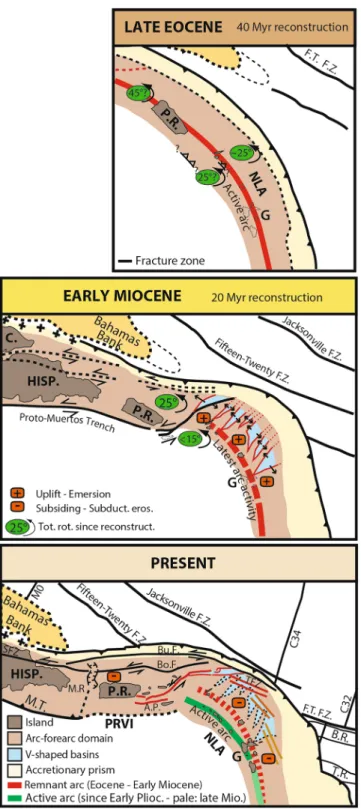
Since the Paleocene–early Eocene time, the collision and oblique subduction of the southeastern extension of the Bahamas Bank has progressively swept westward along the Caribbean Plate (Figure 7). A global tectonic rearrangement of the Caribbean-North American Plates boundary generated a great left-lateral strike-slip system possibly extending from the Cayman trough pull-apart basin to the Anegada Passage passing south of Puerto-Rico (Pindell & Barrett, 1990) since the Eocene (Ross et al., 1986). To the north, the Oriente Fault and the Puerto-Rico Trench have also undergone left-lateral strike-slip deformation. The Bahamas Bank collision and this shear zone have resulted in a progressive increase in the NLA Margin convexity and counterclockwise block rotations. The margin has recorded a rotation of 25° in Puerto-Rico (Calais et al., 2016; Mann et al., 2002, 2005; Reid et al., 1991) and 15°–25° in St Barthelemy (Philippon, van Hinsbergen, et al., 2020) since the end of the Oligocene. The margin convex bending implied N-S to NW-SE extension in the Lesser Antilles Forearc (Jany et al., 1990; Masson & Scanlon, 1991) and counterclockwise block rotations in the context of a left-lateral shear zone would result in similarly directed extension, at the PRVI Margin segment. This extension at least partly, caused the opening of the Sombrero and Malliwana Basins (Laurencin et al., 2017), the activity of the extensive faults bounding the Anguilla Bank and the Kalinago Basin as well as the subsidence of the latter at the Oligocene-early Miocene (Cornée et al., 2019). This trench-parallel extension is consistent with N40°–90° normal fracturing observed at the scale of the forearc domain.
Figure 7. Kinematic reconstruction of the Northern Lesser Antilles Subduction Zone since 40 Ma modified from
Mann et al. (2005), Pindell and Barrett (1990), and Calais et al. (2016). Caribbean Plate fixed. Guadeloupe Island (G) is considered fixed with the Caribbean Plate interior. Puerto Rico (PR) is back rotated as indicated but its exact location is speculative and based on a geometric restoration across the Anegada Passage (AP). BR, Barracuda Ridge; BoF, Bowin Fault; BuF, Bunce Fault; C, Cuba; FT, Fifteen Twenty; FZ, Fracture Zone; Hisp, Hispaniola; J, Jacksonville; MR, Mona Rift; MT, Muertos Trough; PR, Puerto-Rico; SFZ, Septentrional Fault Zone; TFZ, Tintamarre Faults Zone; TR, Tiburon Ridge.
Thus, this fracturing and the V-shaped valleys opening are likely to be related to the increasing margin convexity following the Bahamas Bank collision possibly assisted by left-lateral strike-slip deformation propagating eastward from the Cayman Trough, during the Oligocene (Figure 7). By the middle-Miocene, Anegada Passage tectonics dissociated the PRVI Margin segment from the NLA. Plates interaction at the convex subduction zone triggered a regional emersion all along the NLA Margin from the Sombrero Basin to the Karukera Spur.
Feuillet et al. (2002, 2011) proposed that northward increasing amount of plate motion partitioning along a curved subduction zone generated the V-Shaped basins within a lithospheric forearc sliver bounded by a major strike-slip system along the arc. However, no large amount of lateral motion is expected along the in-cipient en-échelon normal fault system in the arc (Laurencin et al., 2019). Moreover, these V-shaped basins mostly open during the Oligocene, when the subduction zone was more linear and thus less prone to plate motion partitioning. Our results rule out the tectonic model of a major control onto NE-SW faults activity and V-shaped valleys opening by strain partitioning in the NLA Forearc.
5.3. Forearc Subsidence, Margin Erosion, and Volcanic Arc Migration
The earliest middle Miocene sub-aerial unconformity UB2 is currently located up-to-7-stwt-deep in margin slope basins suggesting dramatic forearc subsidence, estimated to be up-to-340 m/Myr, since the middle Miocene (∼16 Ma). Consistently, to the south, offshore of Guadeloupe Island, large-scale margin subsid-ence at the Karukera Spur results in significant trenchward tilting of the inner forearc domain (De Min et al., 2015). To the northwest, the PRVI Margin segment has recorded a subsidence greater than 3.2 km since the Pliocene, following subduction of the buoyant ∼20-km-thick southeastern tip of the Bahamas Province (Grindlay et al., 2005).
At the NLA Trench, the oceanic crust, originated from the slow mid-Atlantic Ridge shows a rough topog-raphy, subducting major oceanic transform fault zones and a thin sedimentary fill, which contrast with the oceanic crust offshore of the Central and Southern Lesser Antilles. The South-American Orinoco and Ama-zon rivers are the main source of sediments in the abyssal province (Wright, 1984). The subducting Tiburon and Barracuda Ridges interrupt the northward sedimentary transport by the strong Antarctic Bottom Water current (Deville et al., 2015). As a consequence, the trench fill thickness decreases from >7 km at 11°N (Westbrook et al., 1984) to <500 m at 17°N (Laigle et al., 2013; Laurencin et al., 2017; Pichot et al., 2012). The subducting plate rugosity at the sediment-starved trench provides the mechanical conditions for margin erosion. As a result, from south to north of the ridges, the width of the accretionary prism decreases from >100 km (Deville & Mascle, 2012; Westbrook et al., 1984) to <30 km (Laurencin et al., 2019). We postulate that the NLA Margin has undergone long-term erosion, since the subducting ridges started interacting with the trench at the late Miocene–early Pliocene (e.g., McCann & Sykes, 1984; Pichot et al., 2012).
Moreover, the Tintamarre Faults Zone (Orange lines in Figure 3b) is associated with a major basement thinning (Figure 4 and Supplementary Material). Wide-angle-derived Velocity Vp in the basement ranges from 4.5 to 7.3 km/s from top to bottom in line Ant06 (Klingelhoefer et al., 2018; Laurencin et al., 2018). Based on this velocity, we estimate that the crustal thickness decreases from ∼14.75 km landward from the fault zone to ∼7.7 km at the hanging wall and increases again to ∼10.7 km trenchward from the fault, in 20 km distance from CDP 6400 to 8000 (Figure 4). Similar calculation in line Ant40, from CDP 2400 to 4300, results in estimating a crustal thinning from ∼14.6 and ∼10.1 km landward and seaward of the fault zone respectively to a minimum of ∼5.3 km at the fault zone axis (Figure 4 and Supplementary material). Thus, along the fault zone, the basement thickness is reduced by 28%–48% compared to the outer forearc trenchward and by 48%–64% compared to inner forearc arcward. Although extrapolating any ante-exten-sion basement thickness at the fault zone is uncertain, we can reasonably estimate an up-to-50% crustal thinning. Therefore, forearc extension and thinning, notably along the Tintamarre Faults Zone, is likely to participate to the NLA margin erosion and subsidence during the Neogene. Similarly, at numerous erosive margins, subduction-erosion has generated long-term subsidence and tilting, regional tectonic extension and disrupted topography in the wake of subducting seafloor rugosity and relief (e.g., Clift & Vannucchi, 2004). Moreover, fluids, driven downward into the subduction channel and the subducting plate, then expelled upward at depth to the margin toe, favor margin basal hydrofracturing and erosion
(von Huene et al., 2004). As a result, high subsidence rates, with significant variations through times, are typical for erosional margins.
Moreover, the volcanic activity ceased along the remnant lesser Antilles Arc during the earliest Miocene (Legendre et al., 2018) and resumed ∼50 km landward during the early Zanclean along the present-day arc (Lindsay et al., 2005) implying a volcanic arc retreat rate of ∼2–5 km/Myr. Various investigations (e.g., Allen et al., 2019; Bouysse & Westercamp, 1990) suggest that a slab shallowing triggered this arc landward migration without resolving the question of the causes for this shallowing. In this study, we provide for the first time evidences of a drastic regional post middle Miocene forearc subsidence, which is inconsistent with a slab shallowing able to generate a 50 km landward arc retreat. In contrast, the geographically and chron-ologically consistency between the arc retreat and the forearc subsidence, at an erosive margin, suggests that this retreat is mainly controlled by margin tectonic erosion. Such erosion-related arc migration was described at various subduction zones, as first documented in Tonga (Pelletier & Dupont, 1990), Peru, and Japan (von Huene & Lallemand, 1990) for instance.
We thus postulate that subduction of an old, sediment-starved, rough, fractured, hydrated, possibly ser-pentinized oceanic basement underneath the NLA Margin has interrupted the previously rather con-tinuous accretionary regime, triggered drastic frontal erosion of the accretionary prism and enhanced fluid release at depth, generating upper-plate hydrofracturing and basal erosion. Such drastic erosion is likely to result in forearc subsidence associated with westward migration of the deformation front and the volcanic arc.
6. Conclusion
Numerous examples of subduction zones in the world undergo tectonic impact of buoyant province colli-sion, including large-scale blocks rotation, plate boundary curvature, backarc rifting and tectonic escape. Investigating the NLA Subduction Zone sheds new light onto the margin polyphased tectonic evolution that accommodated increasing margin convexity in a context of along-strike transition from subduction to collision.
Based on interpreted high-resolution bathymetric, MCS and WAS data acquired during ANTITHESIS and GARANTI cruises in the NLA Forearc, we identify two main tectonic phases separated by a regional-scale emersion period.
During the Eocene–Oligocene, the Bahamas Bank subduction/collision with the northeastern boundary of the Caribbean Plate has generated a major strike-slip system from the Cayman Trough to the Anegada Pas-sage and a progressive bending of the margin into the current convex geometry. Resulting trench-parallel tectonic extension is accommodated, at least partly, along N40 –90° normal faults, that bound V-Shaped val-leys at the inner forearc. The origin of this prominent NE-SW fracturing in the forearc is thus very unlikely to be related to current strain partitioning. This bending resulted in a regional margin uplift and emersion phases at the early middle Miocene.
Since the middle Miocene, the forearc has recorded regional subsidence and tectonic extension, at least partly accommodated along the N300° normal Tintamarre Faults Zone. This tectonic phase reveal drastic margin basal and frontal tectonic erosion, which has likely generated westward migration of the deforma-tion front and the volcanic arc since the middle Miocene.
Appendix A
The ANTITHESIS and GARANTI cruise teams include: Agranier, A.3, Arcay, D.5, Audemard, F.6, Beslier, M.-O.2, Boucard, M.1, Bouquerel, H.7, Conin, M.8, Cornée, J.J.5, Crozon, J.4, Dellong, D.4, De Min, L.1, de Voogd, B.9, Evain, M.4, Fabre, M.1, Gay, A.5, Graindorge, D.3, Gwandai, W.2, Heuret, A.10, Klingelhoefer, F.4, Laigle, M.2, Lallemand, S.5, Laurencin, M.3, Lebrun, J.-F.1, Legendre, L.1, Léticée, J.L.1, Lucazeau, F.7, Ma-hamat, H.2, Malengros, D.2, Marcaillou, B.2, Mazabraud, Y.1, Mercier de Lepinay, B.2, Olliot, E.5, Oregioni, D.2, Padron, C.4, Pichot, T.11, Prunier, C.3, Paulatto, M.12, Quillévéré, F.13, Ratzov, G.2, Renouard, A.2, Rolan-donne, F.14, Rousset, D. 9, Schenini, L.2, Thomas, Y.4, Vitard, C.2, Yates, B.2
Data Availability Statement
Every geophysical data of the ANTITHESIS cruises are available on the internet site of the French Ocean-ographic Fleet (https://campagnes.flotteoceanographique.fr/search). Interested readers select the “Antith-esis” campaign and the desired data set in field “Data Managed by SISMER.” Once every needed data set is selected, the readers can send a request form from “My basket” page.
References
Allen, R. W., Collier, J. S., Stewart, A. G., Henstock, T., Goes, S., & Rietbrock, A. (2019). The role of arc migration in the development of the Lesser Antilles: A new tectonic model for the Cenozoic evolution of the eastern Caribbean. Geology, 47, 891–895. https://doi. org/10.1130/G46708.1
Andreieff, P., Westercamp, D., Garrabé, F., Bonneton, J.-R., & Dagain, J. (1988). Stratigraphie de l'île de Saint Martin (Petites Antilles Septentrionales). Géologie de la France, 2–3, 71–88.
Angelier, J. (1978). Tectonic evolution of the Hellenic Arc since the late Miocene. Tectonophysics, 49, 23–36. https://doi. org/10.1016/0040-1951(78)90096-3
Bangs, N. L. B., Christeson, G. L., & Shipley, T. H. (2003). Structure of the Lesser Antilles subduction zone backstop and its role in a large accretionary system. Journal of Geophysical Research, 108, 2358. https://doi.org/10.1029/2002JB002040
Bonnardot, M. A., Hassani, R., Tric, E., Ruellan, E., & Régnier, M. (2008). Effect of margin curvature on plate deformation in a 3-D numer-ical model of subduction zones. Geophysnumer-ical Journal International, 173, 1084–1094. https://doi.org/10.1111/j.1365-246X.2008.03752.x
Boutelier, D. A., & Cruden, A. R. (2013). Slab rollback rate and trench curvature controlled by arc deformation. Geology, 41, 911–914.
https://doi.org/10.1130/g34338.1
Bouysse, P., Andreieff, P., Richards, M. A., Baubron, J. C., Mascle, A., Maury, R. C., & Westercamp, D. (1985). Aves swell and northern Lesser Antilles ridge: Rock-dredging results from Arcante 3 cruise. In A. Mascle (Ed.), Géodynamique des Caraïbes (pp. 65–76). Paris. Bouysse, P., & Mascle, A. (1994). Sedimentary basins and petroleum plays around the French Antilles. In A. Mascle (Ed.), Hydrocarbon and
petroleum geology of France, special publication of the EAPG (Vol. 4, pp. 431–443). Springer-Verlag.
Bouysse, P., & Westercamp, D. (1988). Effets de la subduction de rides océaniques sur l'évolution d'un arc insulaire: l'exemple des Petites Antilles. Géologie de la France, 2-3, 3–38.
Bouysse, P., & Westercamp, D. (1990). Subduction of Atlantic aseismic ridges and Late Cenozoic evolution of the Lesser Antilles island arc. Tectonophysics, 175, 349–380. https://doi.org/10.1016/0040-1951(90)90180-G
Budd, A. F., Johnson, K. G., & Edwards, J. C. (1995). Caribbean reef coral diversity during the early to middle Miocene: An example from the Anguilla Formation. Coral Reefs, 14, 109–117.
Calais, E., Symithe, S., Mercier de Lépinay, B., & Prépetit, C. (2016). Plate boundary segmentation in the northeastern Caribbean from geodetic measurements and Neogene geological observations. Comptes Rendus Geoscience, 348, 42–51. https://doi.org/10.1016/j. crte.2015.10.007
Church, R. E., & Allison, K. R. (2004). The petroleum potential of the Saba Bank area, Netherlands Antilles.
Clift, P. D., & Vannucchi, P. (2004). Controls on tectonic accretion versus erosion in subduction zones: Implications for the origin and recycling of the continental crust. Reviews of Geophysics, 42, RG2001. https://doi.org/10.1029/2003RG000127
Cornée, J.-J., BouDagher-Fadel, M., Philippon, M., Léticée, J.-L., Legendre, L., Maincent, G., et al. (2020). Paleogene carbonate systems of Saint Barthélemy, Lesser Antilles: stratigraphy and general organization. Newsletters on Stratigraphy. https://doi.org/10.1127/ nos/2020/0587
Cornée, J.-J., Léticée, J.-L., Münch, P., Quillévéré, F., Lebrun, J.-F., Moissette, P., et al. (2012). Sedimentology, palaeoenvironments and biostratigraphy of the Pliocene-Pleistocene carbonate platform of Grande-Terre (Guadeloupe, Lesser Antilles forearc). Sedimentology, 59, 1426–1451. https://doi.org/10.1111/j.1365-3091.2011.01311.x
Cornée, J.-J., Munch, P., Philippon, M. M., BouDagher-Fadel, M., Quillévéré, F., Melinte-Dobrinescu, M., et al. (2019). Oligocene to Pliocene paleogeography of the northern Lesser Antilles arc (pp. 9–13). AGU Fall Meeting San Francisco. Retrieved from https://agu.confex.com/ agu/fm19/meetingapp.cgi/Paper/509947
De Min, L., Lebrun, J.-F., Cornée, J.-J., Münch, P., Léticée, J.-L., Quillévéré, F., et al. (2015). Tectonic and sedimentary architecture of the Karukéra spur: A record of the Lesser Antilles fore-arc deformations since the Neogene. Marine Geology, 363, 15–37. https://doi. org/10.1016/j.margeo.2015.02.007
DeMets, C., Jansma, P. E., Mattioli, G. S., Dixon, T. H., Farina, F., Bilham, R. G., et al. (2000). GPS geodetic constraints on Caribbean-North America plate motion. Geophysical Research Letters, 27, 437–440. https://doi.org/10.1029/1999GL005436
Deplus, C. (1998). Aguadomar cruise. RV L'Atalante. https://doi.org/10.17600/98010120
Deville, E., & Mascle, A. (2012). The Barbados ridge: A mature accretionary wedge in front of the Lesser Antilles active margin. In D. G. Roberts, & A. W. Bally (Eds.), Principles of geologic analysis (pp. 581–607). https://doi.org/10.1016/B978-0-444-53042-4.00021-2
Deville, E., Mascle, A., Callec, Y., Huyghe, P., Lallemant, S., Lerat, O., et al. (2015). Tectonics and sedimentation interactions in the east Caribbean subduction zone: An overview from the Orinoco delta and the Barbados accretionary prism. Marine and Petroleum Geology, 64, 76–103. https://doi.org/10.1016/j.marpetgeo.2014.12.015
Evain, M., Galvé, A., Charvis, P., Laigle, M., Kopp, H., Bécel, A., et al. (2013). Structure of the Lesser Antilles subduction forearc and back-stop from 3D seismic refraction tomography. Tectonophysics, 603, 55–67. https://doi.org/10.1016/j.tecto.2011.09.021
Feuillet, N., Beauducel, F., & Tapponnier, P. (2011). Tectonic context of moderate to large historical earthquakes in the Lesser Antilles and mechanical coupling with volcanoes. Journal of Geophysical Research, 116. https://doi.org/10.1029/2011JB008443
Feuillet, N., Manighetti, I., Tapponnier, P., & Jacques, E. (2002). Arc parallel extension and localization of volcanic complexes in Guade-loupe, Lesser Antilles. Journal of Geophysical Research, 107, 2331. https://doi.org/10.1029/2001JB000308
Grindlay, N. R., Mann, P., Dolan, J. F., & Van Gestel, J.-P. (2005). Neotectonics and subsidence of the Northern Puerto-Rico-Virgin Islands margin in response to the oblique subduction of high-standing ridges. In P. Mann (Ed.), Active tectonics and seismic hazards of Puerto Rico, the Virgin Islands and offshore areas (Vol. 385, pp. 31–60): Geological Society of America.
Heeszel, D. S., Wiens, D. A., Shore, P. J., Shiobara, H., & Sugioka, H. (2008). Earthquake evidence for along-arc extension in the Mariana Islands. Geochemistry, Geophysics, Geosystems, 9, n/a–n/a. https://doi.org/10.1029/2008gc002186
Hirn, A. (2001). SISMANTILLES 1 cruise report. RV Nadir. https://doi.org/10.17600/1080060
Acknowledgments
The authors acknowledge ANTITHE-SIS, SISMANTILLES, and GARANTI scientific and technical teams on board R/Vs L’Atalante and Pourquoi-Pas? for high quality data acquisition and processing. The authors are grateful to the regional council of Guadeloupe that provided Milton Boucard thesis funding. This work is also part of the French ANR17-CE31-0009 GAARANTI program. Multichannel processing has been performed with Geocluster software of CGG and Seismic Unix. The authors would like to thanks Laurent Jolivet and Jim Pindell for their helpful review of early version of this study.
Jany, I., Scanlon, M., & Mauffret, A. (1990). Geological interpretation of combined Seabeam, Gloria and seismic data from Anegada Pas-sage (Virgin Islands, north Caribbean). Marine Geophysical Researches, 12, 173–196. https://doi.org/10.1007/BF02266712
Klingelhoefer, F., Marcaillou, B., Laurencin, M., Biari, Y., Laigle, M., Graindorge, D., et al. (2018). Relation between the nature of the sub-ducting plate, heat flow and fluid escape structures at the Lesser Antilles Island arc. American Geophysical Union Fall Meeting Washing-ton, DC.
Laigle, M., Becel, A., de Voogd, B., Sachpazi, M., Bayrakci, G., Lebrun, J.-F., Evain, M., & Group, t.T.W.R.S.R.w. (2013). Along-arc segmen-tation and interaction of subducting ridges with the Lesser Antilles Subduction forearc crust revealed by MCS imaging. Tectonophysics, 603, 32–54. https://doi.org/10.1016/j.tecto.2013.05.028
Laigle, M., Lebrun, J.-F., & Hirn, A. (2007). SISMANTILLES 2 cruise report. RV L'Atalante. https://doi.org/10.17600/7010020
Laurencin, M. (2017). Etude de la géométrie, de la nature et des déformations de la zone de subduction des Petites Antilles du Nord (PhD thesis, p. 323). Brest: Université de Bretagne Occidentale.
Laurencin, M., Graindorge, D., Klingelhoefer, F., Marcaillou, B., & Evain, M. (2018). Influence of increasing convergence obliquity and shallow slab geometry onto tectonic deformation and seismogenic behavior along the Northern Lesser Antilles zone. Earth and Plane-tary Science Letters, 492, 59–72. https://doi.org/10.1016/j.epsl.2018.03.048
Laurencin, M., Marcaillou, B., Graindorge, D., Klingelhoefer, F., Lallemand, S. E., Laigle, M., & Lebrun, J.-F. (2017). The polyphased tectonic evolution of the Anegada Passage in the northern Lesser Antilles subduction zone. Tectonics, 36. https://doi.org/10.1002/2017TC004511
Laurencin, M., Marcaillou, B., Graindorge, D., Lebrun, J.-F., Klingelhoefer, F., Boucard, M., et al. (2019). The bunce fault and strain parti-tioning in the northern Lesser Antilles. Geophysical Research Letters, 46. https://doi.org/10.1029/2019GL083490
Lebrun, J.-F. (2009). Kashallow 2 cruise. RV le Suroît. https://doi.org/10.17600/9020010
Lebrun, J.-F., & Lallemand, S. E. (2017). GARANTI Cruise. RV L'Atalante. https://doi.org/10.17600/17001200
Legendre, L., Philippon, M., Münch, P., Léticée, J.-L., Noury, M., Maincent, G., et al. (2018). Trench bending initiation: Upper plate strain pattern and volcanism. Insights from the Lesser Antilles Arc, St. Barthelemy Island, French West Indies. Tectonics, 37, 2777–2797.
https://doi.org/10.1029/2017TC004921
Leroy, S., Mauffret, A., Patriat, P., & Mercier de Lépinay, B. (2000). An alternative interpretation of the Cayman trough evolution from a rei-dentification of magnetic anomalies. Geophysical Journal International, 141, 539–557. https://doi.org/10.1046/j.1365-246x.2000.00059.x
Lindsay, J. M., Robertson, R. E. A., Shepherd, J. B., & Ali, S. T. (2005). Volcanic hazard atlas of the lesser Antilless: Seismic Research Unit, The University of the West Indies, Trinidad and Tobago, W.I.
Lopez, A. M., Stein, S., Dixon, T. H., Sella, G., Calais, E., Jansma, P., et al. (2006). Is there a northern Lesser Antilles forearc block? Geophys-ical Research Letters, 33, L07317. https://doi.org/10.1029/2005GL025293
Mann, P., Calais, E., Ruegg, J. P., DeMets, C., Jansma, P. E., & Mattioli, G. S. (2002). Oblique collision in the northeastern Caribbean from GPS measurements and geological observations. Tectonics, 6, 1057. https://doi.org/10.1029/2001TC001304
Mann, P., Hippolyte, J. C., Grindlay, N. R., & Abrams, L. J. (2005). Neotectonics of southern Puerto Rico and its offshore margin. In P. Mann (Ed.), Active tectonics an seismic hazards of Puerto Rico, the Virgin Islands and off-shore areas (Vol. 385, pp. 115–138): Geological Society of America.
Marcaillou, B., & Klingelhoefer, F. (2013a). ANTITHESIS-1-Leg1 cruise. RV L'Atalante. https://doi.org/10.17600/13010070
Marcaillou, B., & Klingelhoefer, F. (2013b). ANTITHESIS-1-Leg2 cruise. RV Pourquoi Pas? https://doi.org/10.17600/13030100
Marcaillou, B., & Klingelhoefer, F. (2016). ANTITHESIS-3 cruise. RV Pourquoi Pas? https://doi.org/10.17600/16001700
Martin-Kaye, P. H. A. (1969). A summary of the geology of the Lesser Antilles. Overseas Geology and Mineral Resources British Geological Survey, 10.
Mascle, J., & Martin, L. (1990). Shallow structure and recent evolution of the Aegean Sea: A synthesis based on continuous reflection profiles. Marine Geology, 94, 271–299. https://doi.org/10.1016/0025-3227(90)90060-W
Masson, D. G., & Scanlon, K. M. (1991). The neotectonic setting of Puerto Rico. GSA Bulletin, 103, 144–154. https://doi.org/10.1130/0016-7606(1991)103<0144:TNSOPR>2.3.CO;2
McCabe, R. (1984). Implications of paleomagnetic data on the collision-related bending of island arcs. Tectonics, 4, 409–428. https://doi. org/10.1029/TC003i004p00409
McCann, W. R., & Sykes, L. R. (1984). Subduction of aseismic ridges beneath the Caribbean Plate: Implications for the tectonics and seis-mic potential of the northeastern Caribbean. Journal of Geophysical Research, 89, 4493–4519. https://doi.org/10.1029/JB089iB06p04493
Müller, R. D., Royer, J.-Y., Cande, S. C., Roest, W. R., & Maschenkov, S. (1999). New constraints on the Late Cretaceous/Tertiary plate tectonic evolution of the Caribbean. In P. Mann (Ed.), Caribbean basins. Sedimentary basins of the world, 4 (pp. 33–59). Amsterdam: Elsevier Science B.V.
Münch, P., Lebrun, J.-F., Cornée, J.-J., Thinon, I., Guennoc, P., Marcaillou, B., et al. (2013). Pliocene to Pleistocene carbonate systems of the Guadeloupe archipelago, French Lesser Antilles: A land and sea study (the KaShallow project). Bulletin de la Société Géologique de France, 184, 99–110. https://doi.org/10.2113/gssgfbull.184.1-2.99
Nakamura, M. (2004). Crustal deformation in the central and southern Ryukyu Arc estimated from GPS data. Earth and Planetary Science Letters, 217, 389–398. https://doi.org/10.1016/s0012-821x(03)00604-6
Neill, I., Kerr, A. C., Hastie, A. R., Stanek, K.-P., & Millar, I. L. (2011). Origin of the Aves Ridge and Dutch–Venezuelan Antilles: Interaction of the Cretaceous ‘Great Arc’ and Caribbean–Colombian Oceanic Plateau? Journal of Geophysical Research, 168, 333–347. https://doi. org/10.1144/0016-76492010-067
Pelletier, B., & Dupont, J. (1990). Effets de la subduction de la ride de Louisville sur l'arc des Tonga-Kermadec. Oceanologica Acta, 10, 57–76. Philippon, M., Cornée, J.-J., Münch, P., Van Hinsbergen, D. J. J., BouDagher-Fadel, M., Gailler, A., et al. (2020). Eocene intra-plate shorten-ingresponsible for the rise of a faunal pathway in the northeastern Caribbean realm. PLoS One, 15, e0241000. https://doi.org/10.1371/ journal.pone.0241000
Philippon, M., van Hinsbergen, D. J. J., Boschman, L. M., Gossink, L. A. W., Cornée, J.-J., BouDagher-Fadel, M., et al. (2020). Caribbean intra-plate deformation: Paleomagnetic evidence from St. Barthélemy Island for post-Oligocene rotation in the Lesser Antilles forearc. Tectonophysics, 777, 228323. https://doi.org/10.1016/j.tecto.2020.228323
Pichot, T., Patriat, M., Westbrook, G. K., Nalpas, T., Gutscher, M.-A., Roest, W. R., et al. (2012). The Cenozoic tectonostratigraphic evolution of the Barracuda Ridge and Tiburon Rise at the western end of the North America-South America plate boundary zone. Marine Geology, 303–306, 154–171. https://doi.org/10.1016/j.margeo.2012.02.001
Pindell, J. L., & Barrett, S. F. (1990). Geological evolution of the Caribbean region. In G. Dengo, & J. E. Case (Eds.), The Caribbean region (Vol. H, pp. 405–433). Boulder, CO: Geological Society of America. https://doi.org/10.1130/DNAG-GNA-H.405
Pindell, J. L., Cande, S. C., Pitman, I. I. I., Rowley, D. B., Dewey, J. F., LaBrecque, J. L., & Haxby, W. F. (1988). A plate-kinematic framework for models of Caribbean evolution. Tectonophysics, 155, 121–138. https://doi.org/10.1016/0040-1951(88)90262-4