HAL Id: hal-01654154
https://hal.archives-ouvertes.fr/hal-01654154
Submitted on 3 Dec 2017
HAL is a multi-disciplinary open access
archive for the deposit and dissemination of
sci-entific research documents, whether they are
pub-lished or not. The documents may come from
teaching and research institutions in France or
abroad, or from public or private research centers.
L’archive ouverte pluridisciplinaire HAL, est
destinée au dépôt et à la diffusion de documents
scientifiques de niveau recherche, publiés ou non,
émanant des établissements d’enseignement et de
recherche français ou étrangers, des laboratoires
publics ou privés.
DISCRETE SOLUTION OF THE SCATTERING
PROBLEM APPLIED TO TARGET-ORIENTED
TOMOGRAPHIC IMAGING
Yder J. Masson, Barbara Romanowicz
To cite this version:
Yder J. Masson, Barbara Romanowicz. DISCRETE SOLUTION OF THE SCATTERING
PROB-LEM APPLIED TO TARGET-ORIENTED TOMOGRAPHIC IMAGING. CMG 2016 : 31st IUGG
Conference on Mathematical Geophysics, Paris. Geo-Physics, from Mathematics to Experiments, Jun
2016, Paris, France. pp.1580 - 1599. �hal-01654154�
CONFERENCE ONMATHEMATICALGEOPHYSICS2016 06-10 JUNE, PARIS, FRANCE
DISCRETE SOLUTION OF THE SCATTERING PROBLEM APPLIED TO
TARGET-ORIENTED TOMOGRAPHIC IMAGING
Y. Masson
1& B. Romanowicz
1,2 1Institut de Physique du Globe, Paris, France
2University of California, Berkeley, CA, USA
Key words Seismic Imaging, Wave Propagation, Scattering Problem, Inverse Problem
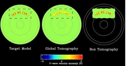
Target-oriented tomographic imaging aims to image localized regions of interest buried inside the Earth. Especially challenging is the situation where neither seismic sources nor seismic receivers are located in the vinicity of the region to be imaged. For example, for the study of a region in the deep mantle we must use remote data since all seismic stations as well as most earthquakes are located near the Earth’s surface. In this case, we need to model wave propagation in the entire Earth in order to obtain the synthetic data (seismograms) needed to solve the inverse problem. Such global simulations are computationally heavy and have to be repeated thousands of times due to the non-linearity of the inverse problem. In order to lighten the computational burden, we developed a domain decomposition method that combines local wave propagation modeling with wavefield extrapolation techniques for fast and accurate imaging of remote targets. We first present a discrete solution to the direct scattering problem. We obtained a discrete formula for the exact boundary condition that is used to confine wave propagation modeling within a sub-volume of arbitrary shape, and, a discrete formula for the Helmholtz-Kirchhoff integral theorem that is used to extrapolate the numerical wavefield to remote seismic stations. Thanks to these formulas, we are able to compute synthetic seismograms that are exactly similar to thoses that would be obtained if we were modeling wave propagation in the entire Earth, but, at a reduced computational cost. Then, we investigate the tomographic imaging problem or inverse scattering problem where seismic records (full-waveforms) are inverted to deduce the visco-elastic structure of the propagating medium. Through numerical examples, we show that we are able to image remote targets in the deep Earth without having to model wave propagation in the entire Earth as illustrated in the figure. Further, we show that our method performs very well in the challenging situation where the propagating medium’s structure is poorly constrained outside the region to be imaged.
Figure 1. Tomographic images of the p-wave velocity structure within an idealized 2D planet. The left panel shows the actual structure of the planet that has a 1D axisymmetric structure similar to the one of the Earth (PREM) onto which we added some velocity anomalies at a depth corresponding to the base of the Earth’s lower mantle. The middle panel shows the tomographic image obtained by doing global tomography that requiers to model wave propagation in the entire planet. The right panel shows the tomographic image obtained with the proposed domain decomposition method, here wave propagation modeling is confined within the imaged region.
References
[1] Masson, Yder, Paul Cupillard, Yann Capdeville, and Barbara Romanowicz. On the numerical implementation of time-reversal mirrors for tomographic imaging. Geophysical Journal International, 196(3):1580–1599, 2014.