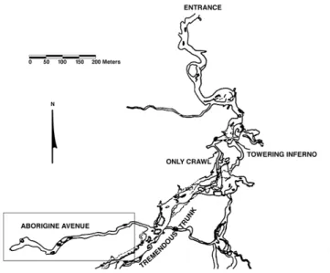
Jaguar Cave (Fig. 1) is a complex cave system in north-central Tennessee. There are approximately 13 km of mapped passages. Prehistoric Native Americans probed deep into the cave interior using cane torches for light.
Ancient cavers would have entered through the large, eas-ily accessible cave mouth, wading into the small stream that emerges in times of normal water flow. Before exiting the cave, this stream courses through large trunk passages, which the prehistoric cavers probably followed into the interior. About 600 m from the entrance, they climbed a steep break-down pile (now known as the Towering Inferno; (Fig. 1)) beyond the wet trunk passages. Direct evidence for the prehis-toric cavers’ route through these wet areas is lacking because flooding and other hydrological processes have destroyed cane charcoal, torch smudges, and any other remains.
From the top of the breakdown pile they entered more pas-sages, including the Only Crawl, where the first evidence of their presence is observable: charcoal and smudges or stoke marks. These marks are locations where the hot ends of the torches were brushed or knocked against walls and ceiling. Exiting from the crawl, they continued through more walking passages. Along the course of this route they passed, but left unmodified, calcium carbonate and calcium sulfate deposits, materials that were of considerable interest to later prehistoric cavers in other caves. From there they entered Tremendous Trunk, a large, mostly dry passage. From Tremendous Trunk the ancient cavers located and explored the easily traversed portions of a 500-m-long dead-end side passage, now called Aborigine Avenue. Near the end of Aborigine Avenue, they turned around and exited, presumably retracing their route to the cave entrance.
PRESERVATION OF PREHISTORIC FOOTPRINTS IN
JAGUAR CAVE, TENNESSEE
P. W
ILLEY1Anthropology Department, Chico State, Chico, CA 95929-0400 USA
J
UDYS
TOLEN892 Vallombrosa Avenue, Chico, CA 95926 USA
G
EORGEC
ROTHERSAnthropology Department, University of Kentucky, Lexington, KY 40560 USA
P
ATTYJ
OW
ATSON2870 Solterra Lane, Missoula, MT 59803 USA
More than 4500 years ago, a group of prehistoric cavers negotiated complicated cave passages and dis-covered a side passage approximately two hours’ journey from the cave’s entrance. They explored the passage toward its end, came to the termination of the easily traveled portion, turned around and exited the same way they entered, leaving footprints and torch material in the cave mud. Their remarkable jour-ney is the earliest evidence of human cave use in the eastern United States.
A total of 274 relatively complete footprints remained in the passage’s moist substrate when the passage was re-discovered approximately 30 years ago. The malleable deposits were pliable then, and remain so today. This pliability made the prints’ preservation vulnerable to subsequent events, agents and process-es. The purposes of this paper are to describe the prehistoric cavers’ accomplishments, document the alteration of the prints, and describe efforts to study and preserve them.
1Contact P. Willey at pwilley@csuchico.edu, 530 898-4793, or the address above.
Figure 1. Jaguar Cave map showing Aborigine Avenue (rectangle); location of the prehistoric footprints. Modified from cave map produced by Lou Simpson with the aid of 39 other NSS cavers.
ARCHAEOLOGICAL REMAINS
Evidence of their journey comes in two forms: charcoal remains and footprints1. The charcoal derives mostly, if not exclusively, from cane (presumably Arundinaria), which abo-riginal people of the Midsouth often used as torch materials (e.g., Watson 1969, pp. 33-36). In addition to the charcoal frag-ments, features involving charcoal include smudges and stoke marks. Charcoal and a few marks are found in the Only Crawl as well as the dry passages beyond it, and are scattered here and there in Tremendous Trunk and in Aborigine Avenue.
The association of charcoal with the exploration is fortu-nate. Not only does the charcoal indicate the route followed by the prehistoric cavers, but also charcoal is amenable to radio-carbon dating, providing chronometric dates of the event. Charcoal collected (Robbins et al. 1981) from a dry passage between the Only Crawl and Tremendous Trunk yielded cali-brated dates of 5465–4870 years B.P. (SI 3005) and 5600–5090 years B.P. (SI 3006). A third charcoal sample was collected from Aborigine Avenue and dated 5575-4990 B.P. (SI 3003). These dates demonstrate dark-zone cave exploration more than 5,000 years ago during the Late Archaic period.
These dates are the earliest from deep cave interiors of the eastern and southeastern United States. The only earlier dates for deep cave use in the United States come from a Colorado cave where a 45-year-old male died nearly 8,000 years ago (Mosch & Watson 1996, 1997) and from Idaho ice caves that were apparently used for meat preservation 8,000 years ago (Henrikson 2003).
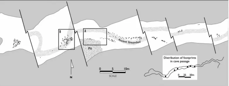
The other source of evidence regarding prehistoric cave exploration, other than charcoal, is footprints (Fig. 2). Left in the soft substrate of Aborigine Avenue’s floor, 274 relatively complete prints have been identified. Most of the prints appear to have been made by bare, unshod feet (Fig. 2A), but one of the prehistoric cavers may have been wearing some sort of footgear (Robbins et al. 1981; (Fig. 2B)), called “moccasins” in the preliminary publication. It is likely that these moccasins were not made of hide, but rather were woven of tough veg-etable fibers like the footgear found in dry portions of other caves (see Watson 1969, p. 36-41, and King 1974 for exam-ples).
The footprints are not continuous in Aborigine Avenue from the entrance to the rear of the passage. There are inter-ruptions in the trail (Fig. 3). These discontinuities in the foot-print trail were caused by the prehistoric cavers walking on harder portions of the cave floor, where their feet left no impressions.
The trails generally follow the most easily traveled route through Aborigine Avenue. Footprints indicate that the cavers simply walked through the passage, occasionally deviating
from the easiest route to inspect cave passage features. Some of these detours, such as the examination of pits in the floor of the passage, may indicate attempts to find alternate routes through the cave as well as additional passages. For example, at least one prehistoric caver walked to the edge of a pit, appar-ently examined the drop-off, and, finding no alternative pas-sage, continued along Aborigine Avenue (Fig. 4).
In addition to such exploratory searches, one person devi-ated from the main route to inspect a fallen flowstone column (Fig. 5). Following the inspection, the prehistoric caver returned to the trail that the others were making to the end of the easily traveled portion of Aborigine Avenue. There is another 130 m of passage, requiring belly crawling, beyond the last prehistoric footprints, but the ancient cavers apparently did not explore this crawlway. Instead, they milled about on the muddy portion of the walking passage, then turned around and headed back to Tremendous Trunk.
Detailed analysis of the footprints identified microerosion-al differences among some of them, suggesting that there were at least two trips into Aborigine Avenue (Robbins et al. 1981).
Figure 2. Prehistoric footprints in Aborigine Avenue. A (top) unshod footprint; B (bottom) shod footprint. CRF photos, November 1976.
1 The “footprints” in Jaguar Cave are not footprints in the strict sense of the term. Technically they are foot impressions. Foot impressions indicate the three-dimensional imprints left by feet in plastic materi-als, such as those in wet sand or in the mud of Aborigine Avenue. Footprints, on the other hand, refer to the two-dimensional oils, blood, inks or other liquids left by the soles of feet on hard, unyielding sur-faces. The tracks in Jaguar Cave are technically foot impressions, but we call them footprints here based on established precedent, and continued in adherence to convention.
These combined trips involved nine individuals, including members of both sexes, and adults as well as a possible ado-lescent (Robbins et al. 1981). Recent research (Watson et al. in press) established that there were more prints directed out of the passage than into the passage. This fact indicated an emphasis on exploration, ambling and searching while going into the passage, and a more direct journey while exiting.
PREHISTORIC ALTERATION OF THE PRINTS
The prints discernible today are the “survivors” of the total number left more than 5,000 years ago, a subset of the actual number made. The processes affecting that survival occurred in two periods: an early period when the prehistoric cavers
Figure 3. Map of Aborigine Avenue, showing prehistoric footprint distribution (small dots). The segments of the passage shown are indicated by locations of the large dots on the insert. A is enlarged in Fig. 4; B is enlarged in Fig. 5. Based on the original detailed map by Michael Voligny.
Figure 4. Detail of prehistoric footprints near pit edge sug-gesting reconnaissance. This location is indicated by A in Fig. 3; details from master footprint map by Michael Voligny.
Figure 5. Detail of prehistoric footprint trail going to fallen column (upper center) suggesting examination of cave fea-tures. This location is indicated by B in Fig. 3; details from master footprint map by Michael Voligny.
themselves and natural processes dominated, and a recent peri-od when mperi-odern cavers and researchers have had marked effects.
The modifications of the prints started when the prints were being made. Prehistoric cavers who were following the leaders walked in their predecessors’ tracks, altering and obscuring some of the prints. In addition, if there were at least two separate prehistoric parties that went into Aborigine Avenue, then the second party, and any subsequent parties, would have walked over and destroyed the preceding parties’ footprints. We suspect that a substantial number of the total set of prints made was obscured in this manner.
Following the last prehistoric caver’s departure from Aborigine Avenue, the prints were left untouched by humans for thousands of years. During those millennia, the prints con-tinued to be altered by natural processes. As an example previ-ously mentioned, one researcher observed greater micro-ero-sion on some of the prints than others suggesting, to her think-ing, that at least two different visits to Aborigine Avenue were made prehistorically (Robbins et al. 1981). Water dripping from the ceiling has also pocked a few of the prints.
On the other hand, the prints were little affected by other processes. There was no checking or cracking of the substrate after the prints were made; moisture and relative humidity apparently remained consistently high during those thousands of years. No major erosional changes took place. Other than occasional dripping from the passage ceiling, no moving water significantly altered the prints.
RECENT ALTERATION OF THE PRINTS
The cave entrance and wet portions of the cave near the entrance were well-known to Euroamericans since the early 19th century (Hogue 1933). The convoluted route to the rear portions of the cave, however, eluded modern cavers until three decades ago. Once the route up the breakdown slope and through the Only Crawl was rediscovered in the mid-1970s, the rear portions of the cave were found and extensive modern exploration took place. Aborigine Avenue was re-discovered by modern cavers as a part of their exploration in 1976.
Since the prints’ discovery, their destruction accelerated beyond the relatively slow rate resulting from natural alter-ation. Even on the discovery trip, for instance, modern cavers walked over some of the prehistoric prints before recognizing them. Because modern explorers were alert for indications of previous cavers, however, relatively few of the prehistoric footprints were destroyed before they were noticed, thus limit-ing this destruction to the front part of the passage. The care used once the discovery was made ensured protection of pre-historic footprints toward the rear of the passage.
The footprint discovery was reported to Watson. She agreed to undertake the daunting task of documenting the prints, supported by Cave Research Foundation (CRF) and National Speleological Society (NSS) members as well as Washington University (St. Louis) anthropology and
archaeol-ogy students. Watson’s initial efforts to preserve the footprints included posting a sign and placing surveyors’ flagging. A con-spicuous sign was posted at the entrance to Aborigine Avenue describing the importance of the prints and contact information for those who wished to know more. In addition to the sign, areas in the passage with prints were marked with survey tape, indicating sensitive areas to be avoided.
Watson’s archaeological research in Aborigine Avenue included collecting charcoal samples and dating them. She also oversaw photographing, measuring, mapping, and, in some cases, casting selected prints (Fig. 6). This work indicated that at least 274 footprints were complete enough to enable at least some observations. Data collection for each footprint included three measurements (foot length, heel width, and ball width), and orientation into or out of the passage. The prints were also mapped in relation to one another. Some of the conclusions resulting from that mapping and other observations have already been presented above. They have been reported in a preliminary fashion (Robbins et al. 1981) and are the subject of another, more lengthy paper (Watson et al. in press).
Archaeologists and volunteers altered some of the prints during their fieldwork. As an example of an accidental modifi-cation, there is a modern handprint made during the archaeo-logical work when a student researcher lost her balance and fell toward one of the footprint areas.
In addition to this accidental modification, there were pur-poseful alterations made by the researchers. “Type” footprints were selected representing the nine individuals identified dur-ing the archaeological fieldwork. Those nine footprints were cast to preserve permanent models of them. The casting process, by its nature, destroyed or severely damaged those prints (3.3% of the total 274 mapped prints; Robbins et al. 1981, p. 377).
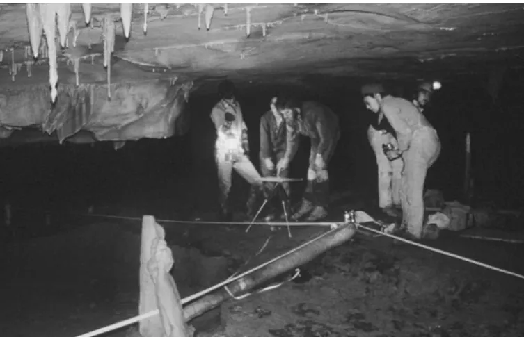
Figure 6. Mapping footprints near fallen column in Aborigine Avenue (see Fig. 5 for map of this area). Left to right: George Crothers, Kathleen Dickerson, Michael Fuller, Sue Schofield (back), Patty Jo Watson (front). CRF photograph by James Goodbar and Kenneth Russell, November 1979.
While the archaeological documentation was going on (1976 through 1986) and after it was completed, modern cavers have walked over some of the prints, altering and mod-ifying them. As an example, sometime between 1996 and 2002, a modern caver ignored the sign at the entrance of Aborigine Avenue and the surveying tape circling the prehis-toric footprints and walked across them, altering at least five of eleven prints near a pit edge. Today nearly all of the areas with prehistoric footprints display at least some modern damage.
In addition to the human visitors, a dog, apparently accom-panying a late 1970s caving party, entered Aborigine Avenue and its pawprints are now present among some of the prehis-toric human footprints near the passage entrance.
RECENT VISITATION TOJAGUARCAVE
We suspect that the amount and rate of the destruction of the prints by modern cavers is correlated to the number of modern cave visitors. Although the number of people visiting Aborigine Avenue has not been systematically documented except in various trip reports, there is another means of appraising overall visitation to the cave interior. A register was established in a prominent location a short distance from the end of the Only Crawl, a location that must be passed by all those heading toward the deeper portions of the cave.
There are, of course, limitations to using the number of registrants as an indication of visitation to Aborigine Avenue. It is obvious that not all people entering the deep portions of the cave signed the register, that not all people registering nec-essarily visited Aborigine Avenue, and that not all registers have been saved, curated, or are available for examination. Nonetheless, the numbers of people registering is an indication of the minimum number of people visiting the deep portion of the cave, and a general indication of the relative number of cavers visiting Aborigine Avenue.
The number of modern cavers registering is summarized and presented in Figure 7. It appears that the number of visi-tors was greatest in the late 1970s and early 1980s, soon after the deep portions of the cave were discovered. During the year with the greatest number of visitors (1979), 250 people regis-tered. That is an enormous number, which consists of several large parties, and reflects a period of active cave exploration, mapping, and research.
The chart (Fig. 7) also indicates a relative absence of visi-tors in the mid-1980s and a complete absence for some years (1984-1987). Rather than a decline in the number of cavers visiting deep portions of the cave, this absence probably reflects a period when the register was being poorly main-tained, was not curated, or at least was unavailable for this tab-ulation. The same may be true for 1991.
The number of visitors in the 1990s is probably more rep-resentative of the use of the deep sections of the cave in that decade as well as the preceding one. From 1990 through 1999, an average of nearly 90 people per year registered. The trend through the 1990s may be more telling about cave visitation than the average for that decade, however. There seems to be a general decrease in deep cave visits from the first half of the 1990s (mean = 108.4 persons per year even including the spu-riously low 1991 figure) to the second half (mean = 70.8 per-sons per year). Perhaps this decrease in registrations indicates a lessening of interest in exploring the cave, as well as the end of research and mapping projects.
There was a spike in cavers registering during the year 2000 (number = 114), the year when the cave was gated. That was not only the beginning of a new millennium, but also the beginning of a new period for protection of the footprints.
The gating of the cave several years ago and creation of a preservation plan provides protection for the prints. During the two years after the cave was gated, the average number of cavers registering fell to 32 visitors per year. If the number of visitors is related to the probability of footprint destruction, then there is hope for preservation of the remaining prints. Potential for destruction of the remaining intact prints persists, however. Understanding the modifications documented in this paper aids protection of these rare and fragile remains. Policies must be established to conserve the traces left by intrepid pre-historic explorers.
ADDITIONAL TECHNIQUES
The archaeological fieldwork during the 1970s and 1980s, completed under difficult circumstances, was highly success-ful. Trips to the cave required long-distance travel, work in the cave was logistically difficult, and preservation of the foot-prints was uncertain. Whether the foot-prints would survive from one trip until the next constantly weighed on the researchers’ minds. Since the original fieldwork was completed two decades ago, new techniques and approaches have become available. These techniques provide the opportunity to docu-ment the prints more precisely and more permanently than
pre-Figure 7. Number of Jaguar Cave visitors registering by year. Note large numbers of visitors in the late 1970s and the early 1990s.
viously possible. They could eliminate the major obstacles to further study: difficulty of access and the time required to reach the prints. Best of all, these techniques can be applied while causing minimal damage to the footprints.
Systematic photography offers a time-tested method for recording the footprints. Although selected prints and foot-print areas were photographed during the original archaeolog-ical work, photographs of all prints in all areas are needed. This would provide a permanent record for each print, and of the prints’ relations to each other and to cave features. For example, Charles Swedlund (1995, n.d.) used a photographic mosaic in Gothic Avenue, Mammoth Cave, Kentucky, to doc-ument 4300 historic names on a long expanse of the ceiling. Using a series of overlapping images made by a camera on a track system, he captured the entire ceiling on one photo-graphic mosaic. A similar approach could be applied to ancient pathways on the floor of Jaguar Cave.
Stereographic photogrammetry is similar in many ways to conventional photography. In addition to the advantages of the latter, however, photogrammetry documents images in three dimensions, producing fine-grained topographic maps. Depths and other three-dimensional details can be observed and mea-sured from the topographic images. Photogrammetry has been successfully applied to the 3.6 million-year-old hominid foot-prints at Laetoli, Tanzania (Agnew & Demas 1998), and offers opportunities for Aborigine Avenue in Jaguar Cave.
Automated laser scanning is an even more recently devel-oped technique that also provides a permanent, high resolu-tion, three-dimensional record. Once at the site, it is quick, rel-atively inexpensive, and avoids some of the problems associ-ated with photography and photogrammetry. It is more precise than either and avoids problems with lighting and time-con-suming setup required by the other techniques. Resulting data can be manipulated electronically to permit accurate measure-ments, to show spatial relationships, and to produce three-dimensional models. For example, an Upper Paleolithic carved horse on a rock shelter wall at Cap Blanc, France, was laser scanned to create a three-dimensional model (Brown et al. 2001).
Ideally speaking, photographic, stereographic photogram-metric, and laser scanning approaches could all be applied to the Jaguar Cave footprints to preserve the maximum amount of information.
OTHER CAVES WITH PREHISTORIC FOOTPRINTS
Prehistoric use of caves included a variety of activities: namely, mining and quarrying various minerals and chert, dis-posal of the dead, and ceremonial uses (Crothers et al. 2002, Watson 1986). In addition to these uses, some caves have been identified as “footprint caves,” those that display no indica-tions of use other than the footprints (Watson 1986). The Jaguar Cave prehistoric footprints, extraordinary as they are, are not unique.
Prehistoric footprints have been found in at least six other southeastern U.S. caves. These caves, together with relevant chronometric dates and published sources, are listed in Table 1.
Access to these prehistoric foot impressions, at least by modern cavers, requires crawling, climbing and walking vari-ous distances into the caves. Some of the preserved footprint sets are hours from the cave entrances. All the impressions are vulnerable to present-day destruction by natural processes, such as erosion, although the greatest threat to their preserva-tion is from that un-natural source: the boot soles of thought-less modern cavers.
In several ways, the footprints in the Unknown Cave por-tion of the Mammoth Cave System are most similar to those in Jaguar Cave. Although only two prehistoric cavers entered Unknown Cave, their exploration was well into the dark zone of a complex cave (more than five hours from the nearest mod-ern, readily accessible natural entry), and among the earliest deep cave explorations (3670 + 50 B.P.; Crothers et al. 2002: 509). These cavers were apparently not involved in mining, quarrying, disposing of the dead, or conducting ceremonies.
There are particulars that set Jaguar Cave apart from Unknown Cave and other footprint caves. Of all the foot impression sets in southeastern caves, those in Jaguar Cave are the greatest in number and the best documented (Robbins et al. 1981, Watson et al. in press). They have been systematically mapped, there are three radiocarbon dates associated with them, some of the impressions have been photographed, and all of the more complete prints have been measured. The Jaguar Cave footprints number more than those in all the other footprint caves in the southeastern U.S. combined. The prehis-toric explorers of Jaguar Cave set a high standard by finding passages that were not rediscovered for thousands of years.
CONCLUSIONS
The Jaguar Cave footprints represent an early example of what seems to have been exploration for exploration’s sake. There was no apparent effort to mine cave deposits that the prehistoric explorers passed during their journey, although speleothems and in at least one locale selenite crystals are vis-ible and easily accessvis-ible. Later, Woodland period miners would surely have rejoiced on finding such deposits and read-ily exploited them.
There are no indications that the cave was used as a mor-tuary facility. Some later prehistoric Southeastern peoples (during the Woodland and Mississippian periods) did employ caves in this way. Within a few miles of Jaguar Cave, there are several caves that were used for burials, presumably by some of these later people. Two of those caves were burial pits, and the third contained human remains near the cave entrance.
There are no obvious indications of ceremonial use in Jaguar Cave. No mud glyphs, petroglyphs, or pictographs have been found so far.
Based on the absence of evidence for these or other activi-ties, we think that the prehistoric people who entered Jaguar Cave were exploring for its own sake. Although we may never know the motives and objectives of these ancient cavers, there is the additional possibility that they had some aesthetic inter-est in the cave and its formations, and that their exploration may have been a successful effort to examine a previously unknown part of their world. If these conjectures are somewhat accurate, then the motivations of the prehistoric Jaguar Cave cavers may have been much the same as those of many pre-sent-day cavers.
With the thrill of discovering prehistoric footprints, or any other fragile cultural remains, comes a grave obligation. We are responsible for preserving them for future cavers. They link the past to the present, and ultimately tie the present to the future.
ACKNOWLEDGEMENTS
Barb Shaeffer, Lou Simpson, Dave Socky, and 39 other members of the NSS mapped the cave. Lou Simpson drafted the map, a portion of which is published here, and M. Clark provided the ink reduction. The original, detailed footprint map of Aborigine Avenue showing all of the measured foot-prints was drafted by Michael Voligny, to whom we are deeply grateful. Louise Robbins contributed significantly to the design and execution of documentation procedures applied to the footprints during the 1970s and 1980s. She also made casts of nine footprint impressions, and began analyses of the com-bined data prior to her untimely death from cancer in 1987. We are thankful to local residents who owned land above the cave, and supported our trips into its remote interior: Mr. and Mrs.
Table 1. Southeastern U.S. caves with prehistoric footprints and associated radiocarbon determinations.
Location Age
Radiocarbon Years Calendar Years Number of References
Before Present Before Presenta Impressions
Aborigine Avenue, 4695 ± 85 5600 – 5090 > 274 Robbins et al. 1981;
Jaguar Cave, TN 4590 ± 75 5575 – 4990 Watson et al. in press;
4530 ± 85 5465 – 4870 present study
3rd Unnamed Cave, 4350 ± 60 5210 – 4830 > 6 Crothers et al. 2002;
TN 3360 ± 60 3810 – 3465 Ferguson 1982, 1983; 3330 ± 70 3805 – 3390 Franklin 1999; 3115 ± 65 3470 – 3085 Simek et al. 1998 3060 ± 50 3380 – 3080 3060 ± 70 3440 – 3075 3050 ± 70 3435 – 3005 2970 ± 40 3320 – 2995 2970 ± 40 3320 – 2995 2950 ± 65 3335 – 2890 2950 ± 110 3380 – 2785 2805 ± 75 3160 – 2755 2745 ± 75 3000 – 2745 2010 ± 60 2120 – 1825
Upper Crouchway, 3670 ± 50 4150 – 3840 > 12 Watson 1969:62-64;
Unknown Cave, KY Crothers et al. 2002
Fisher Ridge Cave, 3175 ± 80 3625 – 3210 > 18 Watson 1982, 1983;
KY 2750 ± 85 3135 – 2745 Kennedy et al. 1984
Sequoyah Caverns, AL 520 ± 50 640 – 500 7 Sneed 1984b
Footprint Cave, 430 ± 60 545 – 315 > 30 Crothers 1997
VA 410 ± 50 530 – 315
Lon Odel Memorial Cave, No radiocarbon dates > 10 Beard 1997a, 1997b
MO
aMaximum of calibrated ages (σ = 2) using CALIB program Version. 4.3, Method A (Stuiver and Reimer 1993). Ages rounded to the nearest five years. bSneed (1984) erroneously reports the Sequoyah Caverns date as A.D. 520, instead of 520 B.P. The determination (estimated by the Smithsonian Institution
Juan Copley, the Misses Lera and Loma Pile, and Mr. and Mrs. James Williams. Three people, who must remain anonymous for reasons of cave confidentiality, provided copies of the cave registers. CRF cavers Roger Brucker, Mark Elliott, James Goodbar, and Kenneth Russell provided photographs. Washington University students, CRF and NSS members, as well as other volunteers aided the archaeological investiga-tions. Byron Wolfe, of Chico State’s Communication Design Department, provided access to and instruction in scanning equipment and software. Joseph Douglas invited us to present a paper in his Cultural Resources in Caves Symposium at the 2003 NSS Convention, Porterville, CA, on which this article is based. We also owe him a debt of gratitude for reviewing the draft of this manuscript and generously sharing his knowledge of Tennessee caves.
REFERENCES
Agnew, N., & Demas, M., 1998, Preserving the Laetoli footprints: Scientific American, v. 279, n. 3, p. 44–55.
Beard, J.B., 1997a, Lon Odell Memorial Cave, in Taylor, R.L., ed., Exploring Missouri Caves, A Guidebook for the 1997 NSS Convention: Springfield, MO, Colorgraphic Publishing, p. 214–218.
Beard, J.B., 1997b, Lon Odell Memorial Cave, a Dade County treasure: Missouri Cave and Karst Conservancy Digest, v. 4, p. 43–48.
Brown, K.A.R., Chalmers, A., Saigol, T., Green, C., & d’Errico, F., 2001, An automated laser scan survey of the Upper Paleolithic rock shelter of Cap Blanc: Journal of Archaeological Science, v. 28, p. 283–289.
Crothers, G.M., 1997, Archaeological site inventory form 40RU0090. Submitted to Virginia Department of Historic Resources, Richmond, Virginia.
Crothers, G.M., Faulkner, C.H., Simek, J.F., Watson, P.J., & Willey, P., 2002, Woodland cave archaeology in Eastern North America, in Anderson, D.G., & Mainfort, R.C., Jr., eds., The Woodland Southeast: Tuscaloosa, University of Alabama Press, p. 502–524.
Ferguson, L.G., 1982, A preliminary report of archaeological investigations at a chert quarry cave in Fentress County, Tennessee. Unpublished manu-script on file, Department of Anthropology, University of Tennessee, Knoxville.
Ferguson, L.G., 1983, Abstract: An archaeological investigation of TCS #FE60: A cave in northern central Tennessee: National Speleological Society Bulletin, v. 45, p. 35.
Franklin, J.D., 1999, The rime of the ancient miners [MA thesis]: Knoxville, University of Tennessee.
Henrikson, L.S., 2003, Bison freezers and hunter-gatherer mobility: Archaeological analysis of cold lava tube caves on Idaho’s Snake River Plain: Plains Anthropologist, v. 48, p. 263–285.
Hogue, A.R., 1933, One Hundred Years in the Cumberland Mountains: Along the Continental Line: McMinnville, TN, Standard Printing Co.
Kennedy, M.C., Hensley-Martin, C., & Watson, P.J., 1984, CRF archeological project —1983: Cave Research Foundation Annual Report, p. 22–23. King, M.E., 1974, The Salts Cave textiles: A preliminary account, in Watson,
P.J., ed., Archaeology of the Mammoth Cave Area: New York, Academic Press, p. 31–40.
Mosch, C., & Watson, P., 1996, The ancient explorer of Hourglass Cave: Evolutionary Anthropology, v. 5, p. 111–114.
Mosch, C., & Watson, P., 1997, An ancient Rocky Mountain caver: Journal of Cave and Karst Studies, v. 59, p. 10–14.
Robbins, L.M., Wilson, R.C., & Watson, P.J., 1981, Paleontology and archeol-ogy of Jaguar Cave, Tennessee: Proceedings of the Eighth International Congress of Speleology, v. 1, p. 377–380.
Simek, J.F., Franklin, J.D., & Sherwood, S.C., 1998, The context of early Southeastern prehistoric cave art: A report on the archaeology of 3rd
Unnamed Cave: American Antiquity, v. 63, p. 663–677.
Sneed, J.M., 1984, The Sequoyah Caverns story: National Speleological Society News, v. 42, p. 178–181.
Stuiver, M., & Reimer, P.J., 1993, Extended 14C database and revised CALIB
radiocarbon calibration program: Radiocarbon, v. 35, p. 215–230. Swedlund, C.A., 1995, Names without faces: The continuing
photodocumen-tation of the names in Mammoth Cave: Proceedings of Mammoth Cave National Park’s Fourth Science Conference, Mammoth Cave, Kentucky, July 6-7, 1995, p. 1–9.
Swedlund, C.A., n.d., Photographic systems designed to document names in Mammoth Cave National Park. Manuscript in possession of the author. Watson, P.J., 1969, The prehistory of Salts Cave, Kentucky: Springfield,
Illinois State Museum Reports of Investigations, n. 16, 86 p.
Watson, P.J., 1982, Notes on a visit to Fisher Ridge Cave. Unpublished field notes dated June 27, 1982.
Watson, P.J., 1983, CRF archeological project and shellmound archeological project—1982: Cave Research Foundation Annual Report, p. 13–15. Watson, P.J., 1986, Prehistoric cavers in the Eastern Woodlands, in Faulkner,
C.H., ed., The Prehistoric Native American Art of Mud Glyph Cave: Knoxville, University of Tennessee Press, p. 109–122.
Watson, P.J., Kennedy, M.C., Willey, P., Robbins, L., & Wilson, R.C., In press, Prehistoric footprints in Jaguar Cave, Tennessee. Journal of Field Archaeology.