Mountains Made in Switzerland: Facts and Concerns
in Nineteenth-Century Cartography
Daniel Speich
Swiss Federal Institute of Technology (ETH) Zurich
Argument
Cultural history has investigated the appropriation of mountain wilderness in considerable detail, without however systematically including the contributions of science and technology in the process. This paper suggests a way of filling this gap. It argues that cartography was instrumental in giving mountains their modern shape. In the course of the nineteenth century, mountains arguably gained a new factual existence at the intersection of new aesthetic, scientific, economic, and political concerns with landscape. Taking the case of Swiss cartography, the paper shows how mapmakers strived to represent this matter of concern in ever more perfect ways, culminating in the three-dimensional rendering of mountains as plaster reliefs. The paper concludes with the observation that this transformation is to a certain extent irreversible. The mountains made in Switzerland in the nineteenth century are probably here to stay.
The cultural history of the Alps is often recounted as a master narrative of conceptual and physical conquest. It usually begins with mythical “former times,” when mountains were feared as the realm of wild and dangerous beasts, and the few travelers who ventured over high passes such as the Simplon or the Great St. Bernard expected to encounter storms and torments of hellish proportions. But over time, so the account continues, writers began celebrating the Alps for their beauty rather than their savagery. In the nineteenth century, artists, scientific researchers, engineers and early pioneers of tourism opened up the terrain. Inspired in part by the work of poets such as Byron and Shelley, tourists began flocking to the mountains, and with the development of winter sports around 1900, the fate of the Alps as one of the great tourist playgrounds of the world was sealed. Political bodies whose territory encompassed mountainous regions made use of this cultural resource in the construction of their respective national identities.1
Such accounts conceive of mountains as physical realities, more or less unchanged over time, which gradually entered the realm of culture. They take the Alps as matters of fact and build their account of historical change upon the categorical separation of some distinctly modern forms of appropriating this actuality. First, so it is argued, the
poets and painters arrived in order to embrace the sublime. Then the Alps allegedly saw the advent of scientists and engineers who devised strategies of rational order and who aimed at technically conquering Alpine remoteness. Finally, towards the end of the nineteenth century, tourists seem to have started to make use of the avenues opened up by scientists and engineers in order to retrace the artists’ emotional correspondence with Alpine landscape. In this view the work of scientists and engineers is of a different quality than that of artists, tourists, or politicians. The former gave visibility to the mountains as facts while the latter imbued them with meaning.
Contrary to this account, the following argument states that it is not easy to clearly discern between the artists’ appreciation, the scientific investigation, the technological domestication, the tourists’ commodification, or the political instrumentalization of landscapes. Instead of taking the factuality of mountains as a point of departure and then separating categorically the many forms of their appropriation, this paper aims at reconstructing a historical concern with the environment which found its expression in the work of scientists and engineers. Such an approach matches recent thought in art history, notably landscape theory. W. J. T. Mitchell reminds us that “landscape” can be understood as a verb. Landscape is not something given, but something in the making, “a process by which social and subjective identities are formed” (Mitchell 1994, 1). Mountains have to be made in order to exist culturally. In this sense, the practice of landscape painting or the act of composing an Alpine poem are ways of
making landscapes. Other ways of making landscapes might include the consumption of
vistas by tourists through the window of a railway coach or through the physically exhausting effort of an ascent. Also geo-political imaginations form an aspect of the modern relationship between landscape and power. Measuring hills and slopes cartographically or cataloging the flora of a region – in other words, the scientific survey of mountains and their use as laboratory settings in the production of knowledge – can be understood as yet another way of making landscapes. According to Mitchell these epistemic procedures do not connect to the Alpine matters of fact in any way different from, for example, the landscape painters’ oeuvre.
This paper will take a close look into the mapmaker’s workshop and will highlight the ways that cartographers not only registered physical features and depicted environmental facts, but also actively created landscapes and environments that did not exist before.2The argument is not, however, that mountains must be understood as the result of a social construction. Mountains are evidently rather solid entities standing against wind, rain, snow, and ice. But still, the form in which they appeared historically in the course of the nineteenth century was unprecedented: it was the form of clearly identifiable objects with singular characteristics.
All through the nineteenth century cartographers labored on the fundamental question of how to transpose three-dimensional features into a two-dimensional
2The material drawn upon in the following sections stems from an extended research project I conducted together with David Gugerli (Gugerli and Speich 2002; see also Gugerli 1998).
cartographic system. In historically analyzing this major task it seems appropriate to differentiate between matters of fact and matters of concern. Bruno Latour has recently argued that scholars in science and technology studies should recast their interest in the social relevance of matters of fact in a broader way that transcends the alleged alternative between realism and social constructivism. “Reality is not defined by matters of fact,” he writes. “Matters of fact are not all that is given in experience. Matters of fact are only very partial and, I would argue, very polemical, very political renderings of matters of concern.” Consequently, Latour invites critical scholars to carry out research on matters of concern according to a new perspective that he labels a “second empiricism.” In this perspective matters of fact are core issues to which, in Latour’s wording, more “reality” can be added by taking into account the concerns that surround them (Latour 2004, 232).
By putting the cartographer’s work under scrutiny, it is asked to what extent the resulting matters of fact – the mountains – were renderings of specific matters of concern. Art, science, technology, economics, and politics have historically been deeply concerned with landscape. Instead of attributing a higher ontological status to the natural environment it might be fruitful to examine how physical reality has deployed its historical relevance through specific gatherings of natural effects, cultural interpretations, techno-scientific rationalizations, and economic and political uses. The first of the following three sections looks at the way in which the cartographers’ profession discovered the third dimension. In the second section a special focus lies on the importance the engineers attributed to an alleged aesthetic correspondence with nature. The third section highlights the birth of the mountain as an artificial object which was often rendered in plaster. All three chapters bear witness to a new concern with mountains that was specific to the nineteenth century. This concern gave rise to the mountain as a matter of fact.
1. Cartographers Discover the Third Dimension
For engineers of the early nineteenth century, the Alpine range was an uncharted field in two respects. First, only very few surveyors internationally had dared to climb to the higher altitudes before the Swiss Army Engineers started their national mapping endeavor. In 1833 Guillaume-Henri Dufour was elected Chief of the General Staff of the Swiss Army and thus became head of the ongoing ordnance survey. For the French-trained engineer and cartographer it was mandatory that the national territory be covered in its totality, regardless of problems of accessibility. Second, the cartographic representation of hills and slopes on flat paper represented a major challenge. This problem of map design was to become one of the crucial matters in the discipline’s later history. Before taking command, Dufour had worked as an instructor at the Federal Military School in Thun, where he had taught mapmaking, among other subjects. For this purpose he published in 1828 a small textbook entitled
“Instruction sur le dessin des reconnaissances militaires, `a l’usage des officiers de l’´ecole f´ed´erale” (Dufour 1828). The volume dealt with all the relevant aspects of the problem, including systems of hachure, rock depiction, and lettering. In 1833, Dufour was thus well aware of the difficulties involved in cartographic mapping when he told one of his engineers: “I have issued the order that all topographical drawings should be executed strictly to represent the terrain. . . without caring about visual effects. We shall see later on. . . what needs to be done to render our mountains smoothly and to have them emerge from the surface of the paper.”3 The first priority was to collect
adequate information regardless of “visual effect.” The subtleties of relief depiction were postponed to a later phase of the project, and were not addressed until the 1840s.
In the meantime, the problem of rendering height and the shape of the terrain was taken up by a number of private cartographer-entrepreneurs. One of them was Friedrich Wilhelm Delkeskamp, who complemented the vertical perspective selectively with front elevation views of single mountains. In 1835 he published a bird’s-eye view of the central part of Switzerland, which conveyed not only a vista of the “Picturesque Relief of the Classic Swiss Land,” as the title suggested, but also included all relevant information demanded from a good map, such as transport infrastructure, settlements, etc. (see fig. 1). His work was such a success that he envisaged the production of a series covering the whole Swiss Alps including parts of the neighboring countries. However, the 25 sheets of the Swiss ordnance survey, published between 1845 and 1863, destroyed his market and the project was never realized (Delkeskamp and Imhof [1830–35] 1978; Wolf 1879, 212).
Another entrepreneur, Jakob Melchior Ziegler, developed his own procedure for representing hilltops and rock formations that strictly followed orthogonal projection. In 1856 he stated: “The exact knowledge of the unevenness of the earth has increasingly become a requirement.”4The bourgeois nineteenth century was about to discover the
third dimension and expected mapmakers to represent it adequately. As a private entrepreneur, Ziegler capitalized on this growing demand and made cartographic relief depiction the hallmark of his mapping business. His 1850 map of Switzerland was one of the first to aim at an “over-all concept” of the country by carefully indicating elevations (see fig. 2). It was such a success that a revised edition followed in 1857, which Ziegler brought to the attention of his customers by stating: “How should we not confidently hope to be able to hint at the plastic diversity of nature in a single image
3I give all French and German citations in my English translation and add the original in the footnotes. “J’ai arrˆet´e que dans les dessins topographiques on se bornerait `a repr´esenter le terrain. . . sans viser `a l’effet. Nous verrons ensuite. . . ce que nous aurons `a faire pour bien rendre nos montagnes et les faire sortir du papier” (Dufour to Buchwalder, March 21, 1833. Swiss Federal Archives Berne [BAR], E 27 Nr. 22642 HAZ d/3781, Nr. 61).
4“die genauere Kenntnis der Unebenheiten unserer Erdoberfl¨ache [ist] zum steigenden Bed ¨urfnis geworden” (cited in Schertenleib 1994, 164).
Fig. 1.Bird’s eye view of Lake Lucerne by Friedrich Wilhelm Delkeskamp, 1835 (Delkeskamp and Imhof [1830–35] 1978).
by cartographic means?. . . After all, this is what the landscapist does.”5 Ziegler was convinced that a good map should convey more than just technical detail about facts. It ought to express the specific modern concern with mountains that encompassed both scientific precision and aesthetic sentiment. His self-conception was that of an artist portraying the terrain, a technical landscape painter, as it were.
Ziegler located himself in a grand narrative of cartographic progress, leading from the one-dimensional medieval itineraries, via the two-dimensional area depiction of early modern times, and to the quasi three-dimensionality of the modern map, with its systematic integration of information concerning the vertical organization of the terrain. It is important to note that most of the maps before 1800 treated terrain forms as a cartographic content of the same order as watercourses, vegetation, transport networks, or settlements. The locality of hills or mountains indicated using a distinct sign within the semiotic system of cartographic text (MacEachren 1995, 217f.). In a similar semiotic mechanism to, say, a red square denoting the presence of a building,
5“Wie sollte man nicht zuversichtlich hoffen d¨urfen, durch Kartographie in einem Bilde Andeutung ¨uber die plastische Mannigfaltigkeit der Natur geben zu k ¨onnen?. . . Der Landschafter macht es auch so” (Ziegler 1857, 18; for bourgeois visual culture, see also Bigg 2005).
Fig. 2. The Bregaglia, Poschiavo, and Valtellina Valleys. Section of the 1850 map by Jakob Melchior Ziegler (Ziegler 1850).
cartographers used signs in the shape of molehills or fish scales to inform map users about the presence of mountain ranges. A travelers’ map for “Germany and some of its neighbouring countries” from 1791, for example, basically showed Europe as a white plain with single mountains looming in isolation, like the “Brenner Mountain” or the “Simplon Mountain.”6 The basis for these representations was blank abstract space. Not until the nineteenth century did a fundamental difference in the symbolic order of maps separate mountains from other cartographic content. The new cartography carefully matched the continuous flow of topography itself with abstract space as the basis of modern maps. Onto this layer, contents like watercourses, vegetation, transport networks, and settlements were then added (Robinson 1982; Tyner 1992).
In the old semiotic system, readers were not given any indications to recognize specific hills or mountain ranges. However, geologists, for example, increasingly demanded specificity in representation, e.g., as a basis to design typologies of terrain forms (Rudwick 1976). The emerging tourism industry also developed an interest in recognizable standard vistas. But the move to a new cartographic territoriality was
6See Carl Frid. Locher, “Postcurs von Deutschland und einigen angr¨anzenden L¨andern,” in Halem [1791] 1990. Of course, some exceptions are found. Imhof points to the work of Leonardo da Vinci (1502), and especially the Swiss Jost Murer (1566), and Hans Conrad Gyger (1667) (Imhof 1982, 5f.).
mostly furthered by needs in engineering and in military topographical reconnaissance. The reorganization of the major European armies during the French Revolutionary Wars gave rise to the institutional entity of the division, able to maneuver in relative independence from general command. For this, military maps became the major medium of planning, of communication, and of orientation. Commanders however needed not only data concerning relative distances to coordinate marching times, but also depended upon concise information about terrain shape in order to choose the location of battlefields (Howard 1976, chap. 5). Without this gathering of diverse interests the fundamental change in cartographic semiotics would not have taken place.
An early example for the new mapping language stems from a textbook for forest engineers and political economists published in 1822. It posed the problem in the following words: “In the horizontal plan only horizontal distances and horizontal angles can be plotted and then be gauged directly from the drawing.” Yet technical maps should “not only determine these horizontal distances and horizontal angles, but also indicate the angle between the inclined plane and the horizontal plane.” How could this be done? “Which angles of the slopes have to be included into the horizontal plan and how should these be drawn in order to allow for easy charting and recognition?”7 The problem was defined in geometrical terms and the solution given in the book was based on geometry. It followed the suggestion of Johann Georg Lehmann, a Saxonian military cartographer, to transpose the continuous relief step by step into a succession of angles of inclination and to indicate their values by a system of hachure. Slopes were to be represented by small black strokes following the vertical line, to be applied with increasing thickness to indicate steeper inclination (Lehmann 1799; Lehmann 1820).
By the 1830s, Lehmann’s system of slope hachuring was well established as a standard in technical mapping, according to which “the steeper, the darker” offered an accurate representational technique. The ratio of black ink to white space could be linked to a scale that matched the range of slope angles in the given area. A map of the Canton of Aargau of 1848 for example applied a 1:5 ratio of black to white for slope angles of 10◦, a 1:2 ratio for an angle of 20◦and full black for 60◦(Cavelti et al. 1997, 10). But while Lehmann’s system was relatively well suited to flat territories, the Aargau map already exceeded its capacities and it proved completely useless for the depiction of high mountains. One engineer remarked in 1836 that “According to this method one needs a multitude of hachures to represent a summit, which results in a rather dark tone.
7“Es k ¨onnen. . . im Horizontalplan nur Horizontalentfernungen und Horizontalwinkel aufgetragen, und wieder unmittelbar aus der Zeichnung abgenommen warden.” Die Kartenzeichnung m¨usse aber ,,nicht bloss diese Horizontalentfernungen und Horizontalwinkel bestimmen, sondern sie muss auch angeben, was f ¨ur einen Winkel die schiefe Fl¨ache mit der Horizontalfl¨ache macht. . . Welche B¨oschungswinkel m¨ussen im Horizontalplane angegeben werden, und wie soll man selbige zeichnen, dass jeder leicht aus der Zeichnung zu erkennen, und eben so leicht verzeichnet werden kann?” (Haussen 1822, 44).
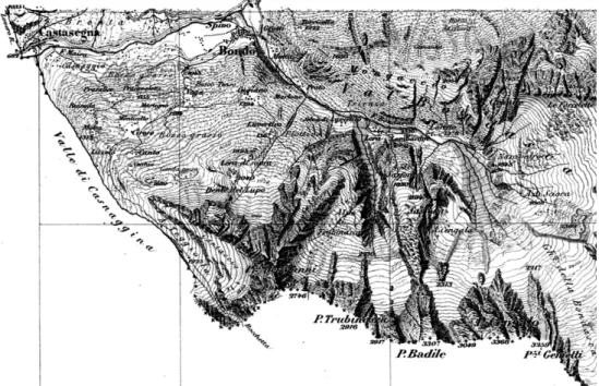
Fig. 3.The Bregaglia Valley. Section of the Swiss Ordnance Map directed by G. H. Dufour (Scale 1:100.000, 1862) (Dufour [1842–1864] 1988).
This dark tone annihilates the general representation of the mountain crest.”8 With
increasing slope the representation of relief shapes became overly dominant within the semiotic system and prohibited the inclusion of additional information concerning rock formation, place names, or other content.
In the official map that eventually resulted from the Swiss ordnance survey, topographic relief was presented in a modified Lehmann style, which completely gave up its technical accuracy in favor of visual effect (see fig. 3). Although it followed the general principle of depicting steeper slopes in darker tones, the tones were not applied according to a fixed scale, as in the Aargau map. And, most importantly, Dufour
8“Car d’apr`es cette m´ethode il faut toujours pour l’expression d’une cime une multitude de hachures, ce qui produit un ton plus ou moins sombre. Par ce ton sombre l’expression g´en´erale de la crˆete de montagne est an´eantie” (Michaelis to Dufour, September 28. 1836, Swiss Federal Archive Bern [BAR], E 27 Nr. 22642 HAZ d/3770; see also Michaelis 1845).
had advised the engravers to introduce oblique lighting to enhance the impression of the relief in the eye of the beholder. Slope hachuring was combined with shadow hachuring, thus the ratio of black to white on slopes exposed to the North-West (bright side) differed from that applied on slopes exposed to the South-East (shady side). The sign of hachure was used to transport two unrelated pieces of information, which could not be precisely separated when reading the map. The hue could not be used to gauge exact slope angles. Several authors heavily criticized this shortcoming. “The system of oblique lighting has the advantage of rendering mountains as a relief, making the map resemble a picturesque image. But this system is a source of deception as it represents soft slopes as deep escarpments if they happen to lie on the shady side.”9
Dufour defended his choice, arguing in favor of an optimal general impression and utmost clarity in the map. While he did not aim at producing picturesque images, he tended to subordinate technical accuracy to overall balance in composition.10 He had also considered an alternative system of relief presentation based on contour lines. This was a technically sophisticated procedure, which linked points of equal height through virtual lines. Slopes were presented in a series of such lines of equal vertical intervals such that their horizontal distance in the map indicated the inclination. Contour lines in close distance referred to steep slopes while large distances between them showed smooth changes in altitude. Due to its technical utility the contour line replaced the hachuring in technical mapping during the second half of the nineteenth century. It played an important role in the production process of the ordnance map of Switzerland, but Dufour refused to adopt the system for final relief depiction because the lines did not offer an adequate impression of the territory. They gave, as one author remarked in 1858, “only a skeleton but not a body”11 and thus had to be overlaid with hachuring
or color shading.
2. The Artistic Genius
When lithographic printing became economical towards the middle of the century, a whole new range of methods of depicting the vertical dimension appeared. An 1868 survey of the field listed 77 competing systems, judging their quality with respect to geometrical lack of ambiguity and the degree to which they allowed “terrain shapes to be drawn naturally.”12 The naturalism displayed here referred to the individual act of
9“Das System der schiefen Beleuchtung hat zwar den Vorzug, dass die Gebirgsmassen reliefartig hervortreten und die Karte sich einigermassen zum malerischen Bilde erhebt; allein dieses System gibt hinwieder Anlass zu mancherlei T¨auschungen, indem es sanft geneigte Bergh¨ange als steile Abst ¨urze erscheinen l¨asst, wenn sie zuf¨allig auf der im Schatten liegenden Seite sich befinden” (Studer and Durheim 1846, 163).
10Dufour to Military Council, September 1. 1846, BAR E 27 Nr. 22642 HAZ d/3778, Kritiken, Nr. 5. 11“nur ein Gerippe und keinen K ¨orper” (Steinhauser 1858, 59).
landscape viewing “in nature,” a romantic experience that tenaciously interfered with the cartographers’ theories and procedures of relief depiction. Technical representation systems such as slope hachuring or contour lines did not satisfy the growing desire for naturalness. Towards the end of the century, cartographers including Albert Heim or Karl Peucker drew upon the physiological optics of Hermann Helmholtz in order to found a scientific coloring system of representing topographic altitude (Heim 1894; Heim 1912; Heim 1927; Helmholtz 1867; Peucker 1898; Peucker 1908). Members of the emerging “Swiss Manner” of relief depiction followed a somewhat different strategy of legitimating their methods. For Fridolin Becker, professor of cartography at the Swiss Federal Institute of Technology (ETH) Zurich, it was clear that maps should be seen as landscape paintings and that the transposition of the three dimensions of the territory into the two-dimensional cartographic representation could only be secured through the artistic genius of the mapmaker (Becker 1910). This assumption became fundamental in the Swiss experience, which in turn subsequently structured global cartographic discourse with respect to relief depiction (Collier, Forrest and Pearson 2003; Imhof 1982).
A fundamental divide between aesthetic and technical considerations was crucial to cartographic discourse. Some mapmakers understood themselves as purely rational technicians who did not at all care about visual effects. Others tried to rationalize the mechanisms of coloring and shadow hachuring. And a third group used the assumed dichotomy in order to create a distinct professional identity for cartographers and mapmakers who were seen as cross-border commuters, as it were, between the technical and the artistic realm. Interestingly, the dichotomy between art and science also has structured the discipline of the history of cartography itself. Until the 1980s, scholars in the field largely focused on cartographic work dating before 1800. In what has been termed the “the ‘Old is Beautiful’-paradigm” (Blakemore and Harley 1980, 25) many authors concentrated on obviously outdated material, marveling at its beauty and sometimes regretting the decline of the pre-technical age. Early mapmaking was assigned to art while modern cartography was located completely within the realm of engineering utility (Bagrow 1964; Goss 1993; Woodward 1987). Art historian Svetlana Alpers has argued that this boundary “between maps and art, or between knowledge and decoration” would have puzzled artists and mapmakers in the seventeenth century (Alpers 1983, 124f.), because the artists of that epoch considered themselves to be visual engineers. I would suggest that the dichotomy is also difficult to apply analytically if one focuses on the artists and mapmakers of the nineteenth century. Never in the history of cartography was there more elaborate reflection on the problem of aesthetic value and visual effect than precisely when the third dimension was about to become an integral part in mapping. For engineering minds, the problem of including precise information concerning the vertical dimension into the two-dimensional map space formed an epistemological problem of considerable complexity. Creating an aesthetic correspondence between the terrain and its representation seemed the only way to solve it (Knodt 1994).
Discourse on this topic was fully elaborated only towards the end of the century. But already in the 1828 instruction Dufour had set the tone. He drew a clear distinction between technical plans and topographical maps. For the former, he allowed only the system of contour lines. Only such a technical procedure would generate the objective knowledge required. For the latter, in contrast, he recommended artistic freedom: “Frankly adopt picturesque drawing,. . . allow complete freedom to the executing hand.”13 Especially with regard to rock formations he completely abstained from a
clear-cut framework of rules. Instead, he emphasized the importance of artistic empathy. “The most difficult aspect of military drawing is without doubt the representation of rocks. It is impossible to establish any rule on this matter other than to strive for an imitation of what one sees. This is why established ability in landscape drawing is of considerable advantage.”14 In this case, not standard procedures, but artistic skills would enable the engineer to generate images that met the demanding requirements of cartographic objectivity.
This instruction was intended to motivate military reconnaissance staff to depict the physical features in a recognizable way. The “real appearance” of hills, large rocks, and mountains should be integrated into the cartographic sign system. However, even for talented landscape painters, two major difficulties stood in the way of this objective. First, the appearance of a given feature revealed itself only in its elevation. The view had to be rendered on the horizontal surface of the paper. Corresponding to the French word “rabattements,” or “turn-downs,” for what is known as a “molehill” in English mapping language, the vista of a specific mountain was literally “turned down” from the vertical to the horizontal. However, turning down verticality into the horizontal plane implied a major violation of the principle of orthogonal projection. The process necessarily concealed a region of the map and the back side of the mountain thus represented remained invisible. The second difficulty arose from the fact that the “real appearance” was only perceivable from a specific standpoint in the field. From which side a mountain should be turned down? Or, as Dufour put it: “The appearance of mountains and big rocks varies indefinitely depending on the point of view.”15 None of these variable appearances should be privileged, but the map offered space for only one.
The challenge consisted in finding a method of representation – a cartographic sign – that could refer to a single mountain in an unambiguous way, making its features recognizable for map users from all possible physical locations in the vicinity. Dufour addressed it by constructing a physically impossible location for the field
13“Adoptez franchement le dessin pittoresque,. . . laissez `a la main qui ex´ecute toute sa libert´e” (Dufour 1828, 7).
14“Ce qu’il y a de plus difficile dans le dessin militaire, c’est sans contredit la repr´esentation des rochers. Il n’est pas possible de poser d’autre r`egle, `a ce sujet, que de s’astreindre `a imiter ce qu’on voit. C’est alors que celui qui est d´ej`a habile dans le dessin du paysage `a un avantage marqu´e” (ibid., 27).
engineer, namely an imaginary view from above. With apparent difficulty of wording he claimed: “In order to imitate these varieties, one has to penetrate oneself of what they must look like – one has to gain a true idea of the forms they would present if one were hovering above and could glide successively across their different parts, for the horizontal projection or the geometric chart that is to be drawn, is nothing else than this appearance.”16 He suggested blending the geometrically-constructed orthogonal
projection with an outlook from above. Cartographers should not compose a bird’s eye view but a sequence of successive vistas. Just like the Dutch landscape artists analyzed by Alpers, they were asked to produce “additive works that could not be taken in from a single viewing point,” resulting in a continuum without perspective (Alpers 1983, 62). The individual mountaineering effort of the cartographers and the subjective standpoint from which their sketches were drawn had to be completely absorbed by the semiotic system in order to make the map consistent and objective. Significantly, this destruction of individuality was the very condition of the possibility of representing the physical features cartographically as unique appearances. Perhaps it is correct to say that the individuality of the observer was dislocated to construct an objective representation that, in turn, rendered the depicted mountain in its individuality.17 In this system, mountains were no longer represented using iconic signs but in meticulous portrait paintings that consisted of a multitude of lines, dots and shades. No one had ever seen this so-called “real appearance,” but with due exercise in map-reading its representation could help identify physical features in the field regardless of one’s location. It made cartographic mountains recognizable from all sides.
The basis of Dufour’s imaginary construction was at the same time simple and rather improbable. He assumed that mountains and rock formations looked more or less alike if seen from the side or from above. True, by 1828 the Montgolfier brothers had been ballooning for some time, but a human being had never flown above the Alps – or any other comparable mountain range – and hence had never been in a position to behold high mountains from above. Despite this lack of empirical evidence, Dufour’s assumption that maps represented the terrain as seen from above became a standard notion in nineteenth-century cartographic discourse. It featured as a topos in the debate concerning the methods of relief depiction. And it worked as a mimetic fallacy in the public appraisal of the ordnance map of Switzerland, once the sheets had left the printing shop and the initial criticism had fallen silent. One euphoric author assured in 1878 that the map enabled him to peer down onto the country like an eagle flying high above (Senn-Barbieux 1878, 84).
16“Il faut pour imiter ces vari´et´es, se bien p´en´etrer de ce qu’elles doivent paraˆıtre, se faire une juste id´ee des formes qu’elles pr´esenteraient si on les voyait en planant au-dessus et en se transportant successivement sur leurs diff´erentes parties, car la projection horizontale ou [le] dessin g´eom´etral qu’il faut en faire, n’est pas autre chose que cette apparence” (ibid.)
17Further investigations would be necessary to connect these observations to a larger history of objectivity (see Daston and Galison 1992 and Daston 1999).
3. The Mountain Object
Looking back in time, one is confronted with a rather vague and multilayered concept of mountains. The term has a long history signifying prominent elevations such as the Mont Ventoux in Southern France, or, in the Swiss case, the “Regina mons” near Lucerne (Jakob 1999). A second layer of meaning refers not to a topographical singularity but to a multitude of peaks. And a third usage, probably the most important one, denoted this multitude of elevated places as an area of economic activity. In this sense, the German word “Alpen” traditionally did not mean a specific group of mountain peaks but described areas of high altitude within the system of livestock farming (Walter 1990, 35). In the travel literature of the eighteenth and the nineteenth century many instances can be found where authors use the word mountain to designate elevated spaces of socio-economic activity rather than clearly defined summits. When meaning a singular spot, the word was mostly used for what today is called a pass. The traveler’s map indicating a “Brenner-Mountain” is a case in point.
In a striking parallel to the unfolding of modern cartography in the course of the nineteenth century these layers of meaning boiled down to one predominant usage of the term: the description of a single entity characterized by its elevation. Early cartographic technicians in the 1830s found themselves confronted with an overwhelming multitude of physical features. One engineer spoke with desperation of “the mountain peaks, which present themselves one next to the other like fir trees in a forest.”18 The first step in reducing this complexity was to construct a triangular
network. In flat areas prominent buildings served as measuring points to establish angles and distances. In the Alpine range, accessible summits allowing for wide views were used for triangulation purposes. However, establishing this geodetic grid in sometimes hostile environments was a tiresome task. In order to secure the congruence of abstract space with physical reality, cartographers had to construct wooden signals on exposed spots. The minutes of the Swiss ordnance survey are filled with lamentations about the hardship involved in this task and the subsequent problem of losing sight of the artefacts once they were set up. In the rough Alpine climate many of them decomposed rapidly. In many instances, the engineers simply misdirected their telescopes, pointing them towards the wrong mountains. It was not always easy to identify one single point of abstract space when looking at it from different sides in the field.
But despite the problems resulting from Alpine ambiguousness, the construction of a geodetic grid together with the methods of relief depiction were a major encouragement for the new tourist practice of mountaineering, which developed in the last third of the nineteenth century. The highest elevation of the Glarus Mountains, the “T ¨odi” (3614 m.) is a good example of the way in which the social community of mountaineers made landscapes in the sense of Mitchell. It is also an exemplary case for
18“les cimes des montagnes, qui se pr´esentent l’une derri`ere l’autre comme les sapins dans les forˆets” (Berchtold to Dufour, May 19. 1835, BAR E 27 Nr. 22642 HAZ d/3769).
differentiating between facts and concerns. In a realist perspective one would assume this physical feature to have (almost) always been there and to have awaited its conquest in the nineteenth century.19The second empiricism, in contrast, represents this specific
mountain as a gathering of concerns of artists, tourists, engineers, and scientists that together stabilized the mountain as a matter of fact.
In the locals’ dialect the name for the peak – t’ ¨Odi – refers to the German word “ ¨Odnis,” meaning a region of little concern, a wasteland at the end of the valley they inhabited (Wozniakowski 1987). This assessment changed around 1800 when amateur naturalists like Pater Placidus a Spescha or Hans Konrad Escher made several attempts to climb the T ¨odi. The wasteland had caught their scientific imagination. The first successful ascent took place in 1824 in what was an unabashed venture of early Alpinism. In the 1830s the engineers of the national survey would have liked to construct a triangulation signal on its summit, but they did not dare to repeat the ascent. Towards the 1860s, bourgeois leisure, sportsmanship, tourism, and scientific inquiry created a unique context in which the T ¨odi Mountain rose to prominence and gained a modern, factual existence. Significantly, the Swiss Alpine Club (SAC) was founded in 1862 in sight distance from the peak. Among other activities the club projected constructing shelters in high altitudes. Its president explained: “For draftsmen, photographers etc. it would become possible to dwell for slightly extended periods in especially picturesque localities. We refer only to the T ¨odi, on whose peak many of us would have liked to spend a whole day, if there had been the reassurance of finding shelter for the night at the altitude of the Yellow Wall.”20 The founders of
the Club explicitly referred to the ordnance map and formulated as a central aim of their activity the systematic exploration of the Alps and the extension of Dufour’s work (D ¨ubi 1913, 25). At the first annual assembly, a survey of large-scale excursion maps of exceptionally interesting areas was decided, starting with the T ¨odi. The excursion map of the T ¨odi appeared in 1866 (Lindt 1866). Such excursion maps, published as supplements to the Club’s yearbook, not only guided the mountaineers in their ascents, they were also the central means of communication among Club members and constituted a frame of reference in which the mountaineering experience could be reproduced socially.
The mountaineers’ obsession rapidly found its expression in plaster. In 1866 the first three-dimensional relief of the T ¨odi was built by the young Albert Heim, who later became a leading geologist. It measured 45 by 41 by 16 centimeters and represented the landscape on a scale of 1:25,000. In 1876 Heim also produced two excursion
19There exists a growing number of monographs on single mountains which apply such a perspective (for the T ¨odi, see Zopfi 2000).
20“[Es w¨are] Zeichnern, Photographen etc. erm¨oglicht, l¨angere Zeit an einem besonders pittoresken Punkte zu verweilen. Wir verweisen hier bloss auf den T ¨odi, auf dessen Scheitel macher gerne einen ganzen Tag zugebracht h¨atte, w¨are er sicher gewesen, etwa auf der H¨ohe der gelben Wand einigermassen Schutz gegen die K¨alte der Nacht zu finden” (“Call for the founding of a Swiss Alpine Club,” by Theodor Simler, 20.10.1862, cited in D ¨ubi 1913, 25).
maps for the SAC featuring the “T ¨odi-Sardona-K¨arpf-Gruppe” (Grieder 2007, 179; Heim 1876). His main interest in rendering a single mountain as an isolated object subsequently shifted to the S¨antis, in the vicinity of which he was born and raised. In addition to a series of detailed maps, from 1871 he also published several panorama views from the S¨antis summit. In 1904 Heim proudly presented his masterpiece to the Museum of Natural History in St. Gallen, a plaster relief of the S¨antis on a scale of 1:5,000 (Heim 1904). Starting with Heim’s work on the T ¨odi, the number of three-dimensional reliefs produced in Switzerland exploded. At the first national industrial exhibition of 1883 the device appeared so often that one observer noted a “Relief mania” (Becker 1883, 3). Practically all leading mapmakers now turned their attention to reliefs. Even Eduard Imhof, one of the the twentieth-century’s most prominent cartographers worldwide, partook in this tradition and produced a series of meticulous mountain sculptures (Imhof 1981). An expert discourse emerged in which such issues as whether the same scale should be applied to the vertical and the horizontal were debated (Becker 1883; Becker 1897). Especially for reliefs covering very large areas, the vertical dimension was sometimes deliberately augmented to safeguard the impression of a mountainous scenery. On the other hand, scientific precision required a unity of scale. This was a problem in the planned – but not executed – project of commissioning the Swiss government to produce a relief covering the whole of Switzerland at a scale of 1:25,000 (Siegfried 1879, 68).
Reliefs were trophies of personal achievement but they also were seen as knowledge-producing machines, mostly in geology, where they were thought to exceed maps in usefulness. From the 1860s, school teachers all over the country worked with their pupils to visualize local topography using reliefs. Natural History Museums and geographical departments at the universities started to build up collections for educational and research purposes. One teacher and relief constructor wrote: “Even if one perfectly knows how to read a map, a good relief is over and again a source of information and directs the attention of the observer to things he would have missed on a map – as if he could quickly fly over the landscape.” To illustrate his point he declared that even the most aesthetically-refined map could not properly convey the steepness of the T ¨odi’s slopes.21
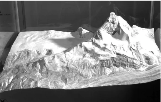
Xaver Imfeld, a railway engineer, cartographer, and panorama drawer, excelled at the art of rendering mountains in plaster (Cavelti Hammer 2007). He created at least 11 large models of parts of the Swiss Alps and using galvanization manufactured countless small metal models of different mountains to be used as souvenirs. For the second national industrial exhibition of 1896 in Geneva, he prepared a model of the Matterhorn, some copies of which exist to this day (fig. 4). Commissioned by the Jungfrau Railway Company, Imfeld put together in 1897 a team of 30 collaborators
21“Selbst wenn man Karten zu lesen versteht, gibt ein gutes Relief immer wieder neue Aufkl¨arung und l¨asst den Blick des Beschauers auf Dinge fallen, die ihm auf der Karte entgangen sind, fast wie wenn er die Gegend in raschem Flug durchwanderte” (Wettstein 1884, 278).
Fig. 4.Relief of the Matterhorn by Xaver Imfeld (Scale: 1:5.000, 96×140 cm, 1896). Museum
of Natural History, Winterthur. Photography by Adrian Bircher.
to manufacture a large relief of the Jungfrau range for the 1900 World Fair in Paris. The piece measured 5.5 by 4.5 meters and featured 600,000 tiny green brushes representing trees. The church painter Anton Stockmann first painted it, and in 1902 Fridolin Becker refreshed the colors.22
One reason for the proliferation of reliefs in Switzerland was a strategic shift in official cartography. When Hermann Siegfried took over the federal topographical bureau in 1865, Swiss mapping was in the process of diversifying enormously. New agents including mountaineers or private cartographers producing maps for schools took up Dufour’s emphasis on aesthetic value and further perfected relief depiction. Official map-making, in contrast, focused again on technical accuracy. The second ordnance map of Switzerland was immensely richer in detail than the first, as the scale had been enlarged from 1:100.000 to 1:50.000 for the Alpine region and to 1:25.000 for the rest of the country.23Under Siegfried, rock drawing according to the imagined
22<http://www.terrainmodels.com/imfeld.html> (17.04.2007). The Jungfrau model was displayed in several European cities and then permanently exhibited in the Alpine Museum in Munich where it was destroyed in 1945.
23The series comprised 142 sheets in 1:50,000 and 462 sheets in 1:25,000.<http://www.stub.unibe.ch/maps/ ta/> (17.04.2007).
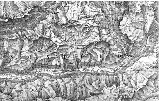
Fig. 5.Lower Part of Bregaglia Valley. Taken from the second Swiss Ordnance Map, section 9, sheet XX “Castasegna,” published in 1877. Source: Siegfried, Hermann 1870–1949: Topographischer Atlas der Schweiz im Massstab der Originalaufnahmen (1:25,000 & 1:50,000) nach dem Bundesgesetz vom 18. Dezember 1868 vom Eidg. Stabsbureau ver ¨offentlicht unter
der Direktion von Oberst Siefried, gestochen von H(einrich) M ¨uhlhaupt (et al.), Bern.
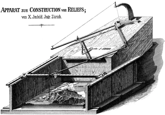
vertical perspective was refined. But oblique lighting was completely abandoned for enhancing relief effect and contour lines replaced slope hachuring. The 604 sheets of the revised atlas that appeared between 1870 and 1949 resembled technical plans and were difficult to read for laypersons (fig. 5). The engineering perfection negated three-dimensional impressions while the contour lines offered a new basis for appropriating the plastic body of the Alps. In 1896 a mechanical apparatus was brought on the market by Xaver Imfeld, that enabled the reproduction of cartographic patterns as a physical relief. One arm of the pantograph-like device followed contour lines on a map while the other arm guided the cutting of shapes (fig. 6).
Conclusion
In the early nineteenth century professional cartographers discovered the third dimension. Representing the terrain became a major concern to the mapmakers of this period, who designed many competing sign systems and graphical methods. To a certain
Fig. 6.Apparatus for the construction of a relief from a map. Xaver Imfeld, 1896.
Source: Exposition Nationle Suisse. Cartographie Groupe XX, Catalogue sp´ecial, Geneva 1896.
extent, towards the end of the nineteenth century, mountains had become a productive laboratory of cartographic knowledge production. Significantly, all the procedures designed in this analytical setting in one way or another complemented mechanical techniques with additional elements which lacked exact precision. Cartographers and mapmakers found themselves increasingly faced with an assumed dichotomy between technical rationality and aesthetic quality. This was especially true in the Swiss experience.
According to the strong tradition of Alpine landscape painting, and in parallel with the unfolding commodification of mountainous sceneries, the engineers located the factual essence of mountains not only in their calculable physical form but also in a specific imagery. A certain tension arose between on the one hand the engineers’ task of surveying the continuum of the earth’s surface objectively and on the other a new obsession with the individuality of physical features. If one tentatively thinks of mountains – and of the Swiss Alps in particular – not as matters of fact, but as renderings of matters of concern, these dichotomies lose importance. Instead, the preoccupation with the Alps in the nineteenth century appears to have been a broadly based cultural phenomenon that reached into many realms of social practice. It can
well be described if one follows Bruno Latour’s suggestion of a “second empiricism” – an empiricism which does not assume that cultural appropriations are in any way ontologically different from the realm of facts. We then see an emerging concern with landscape which brought to the front a new factual appearance of mountains as identifiable objects with singular characteristics.
Depicting mountains in a nineteenth-century map was an act of producing facts in two senses: first it turned single mountains into individual objects, and second it bestowed upon them an objective factuality. The desire to capture exhaustively the essence of the terrain found its apogee in three-dimensional plaster rendering. Some of the leading Swiss mapmakers considered plaster models to be the most adequate form of terrain representation and thought that reconstructing mountains in this way was the best possible answer to the cartographic challenge. Xaver Imfeld’s work, for example, reflected the late nineteenth-century fascination with Alpine landscapes. Visualizing single mountains and reproducing their appearance with the highest possible fidelity was a central component of this practice that reached far into popular culture. Looking with historical hindsight at this obsession with mountains makes it difficult to locate the boundaries between the aesthetic, the scientific, the engineering, and the tourist realms.
The fact that categories of art, economy, science, and technology were so thoroughly combined in ventures of this kind is an expression of the inextricable blending of their traces in the history of the Alpine world. This combination of interests and concerns was determinant in the emergence of mountains as single, identifiable objects. However, the mountains made in Switzerland in the nineteenth century are now with us to stay because cartographic transpositions as described in this paper are to a certain degree historically irreversible.
References
Alpers, Svetlana. 1983. The Art of Describing: Dutch Art in the Seventeenth Century. Chicago: University of Chicago Press.
Bagrow, Leo. 1964. History of Cartography. English edition revised and enlarged by R. A. Skelton. Cambridge, Mass.: Harvard University Press.
Beattie, Andrew. 2006. The Alps: A Cultural History. Oxford and New York: Oxford University Press. Becker, Fridolin. 1883. ¨Uber Karten und Reliefs und die Bedeutung der letzeren f¨ur den milit¨arischen Unterricht.
Sonderabdruck aus der Schweizerischen Zeitschrift f¨ur Artillerie und Genie. Frauenfeld: Huber.
Becker, Fridolin. 1897. Das topographische Relief der Schweiz in seiner Bedeutung f¨ur die Landeskunde.
Sonderabdruck aus der “Schweiz. Monatschrift f¨ur Offiziere aller Waffen.” Frauenfeld: Huber.
Becker, Fridolin. 1910. “Die Kunst in der Kartographie.” Geographische Zeitschrift 16:473–490.
Bigg, Charlotte. 2005. “Das Panorama, oder La Nature A Coup d’Oeil.” In Bilder der Natur – Sprachen
der Technik, edited by David Gugerli, Michael Hagner, Michael Hampe, Barbara Orland, Peter Sarasin,
and Jakob Tanner, 33–55. Zurich: Diaphanes.
Blakemore, Michael J. and John Brian Harley. 1980. Concepts in the History of Cartography. Review and
Cavelti Hammer, Madlena. 2007. “Xaver Imfeld (1853–1909) als Reliefbauer.” In Europa Miniature. Die
kulturelle Bedeutung des Reliefs, edited by A. B ¨urgi, 16-21. Jahrhundert= il significato culturale dei rilievi plastici, XVI-XXI secolo, 165–174. Zurich: NZZ Libro.
Cavelti Hammer, Madlena, Hans-Uli Feldmann, and Markus Oehrli. eds. 1997. Farbe, Licht und Schatten.
Die Entwicklung der Reliefkartographie seit 1660. Begleitheft zur sonderausstellung vom 5. April bis 3. August 1997 im Schweizerischen Alpinen Museum Bern. Murten: Cartographica Helvetica.
Collier, Peter, David Forrest, and Alastair Pearson. 2003. “The Representation of Topographic Information on Maps: The Depiction of Relief.” The Cartographic Journal 40:17–26.
Daston, Lorraine and Peter Galison. 1992. “The Image of Objectivity.” Representations 40:81–128. Daston, Lorraine. 1999. “Objectivity and the Escape from Perspective.” In The Science Studies Reader,
edited by Mario Biagioli, 110–123. London: Routledge.
Delkeskamp, Fr´ederic Guillaume and Eduard Imhof. [1830–35] 1978. Malerisches Relief des klassischen
Bodens der Schweiz. Faks.Ausg. von: Die Delkeskamp-Karte; topographisch-k¨unstlerisches Bild der Urschweiz aus den Jahren 1830–1835. Frankfurt a.M., Dietikon, Zurich: Stocker.
D ¨ubi, Heinrich 1913. Die ersten f¨unfzig Jahre des Schweizer Alpenclub, Denkschrift im Auftrag des Centralcomitees
verfasst. Bern.
Dufour, Guillaume-Henri. 1828. Instruction sur le dessin des reconnaissances militaires, `a l’usage des officiers de
l’´ecole f´ed´erale. Genf: Barbezat et Delarue.
Dufour, Guillaume-Henri. [1842–1864] 1988. Topographische Karte der Schweiz vermessen und hrsg. auf Befehl der eidgen ¨ossischen Beh ¨orden; aufgenommen und reduziert durch eidgen ¨ossische Ingenieure unter der Aufsicht des Generals G. H. Dufour. Nachdruck der Erstausgabebl¨atter von 1842–1864, Massstab: 1:100,000. Bern: Bundesamt f ¨ur Landestopographie.
Goss, John. 1993. The Mapmaker’s Art: An Illustrated History of Cartography. Skokie, IL: Rand McNally. Grieder, Susanne. 2007. “Meisterst ¨ucke und Kuriosit¨aten. 200 Jahre Reliefbau – Streifzug durch die
Reliefsammlung des Schweizerischen Alpinen Museums.” In Europa Miniature. Die kulturelle Bedeutung
des Reliefs, edited by A. B ¨urgi, 16-21. Jahrhundert= il significato culturale dei rilievi plastici, XVI-XXI secolo,
175–189. Zurich: NZZ Libro.
Gugerli, David. 1998. “Politics on the Topographer’s Table: The Helvetic Triangulation of Cartography, Politics, and Representation.” In Inscribing Science: Scientific Texts and the Materiality of Communication, edited by T. Lenoir, 91–118. Stanford: Stanford University Press.
Gugerli, David and Daniel Speich. 2002. Topografien der Nation. Politik, kartografische Ordnung und Landschaft
im 19. Jahrhundert. Zurich: Chronos.
Halem, Gerhard Anton von. [1791] 1990. Blicke auf einen Theil Deutschlands, der Schweiz und Frankreichs
bey einer Reise vom Jahre 1790. Bremen: Edition Temmen.
Haussen, Johann Salomon. 1822. Theoretisch-praktische Anweisung zum Plan- und Situationszeichnen zunaechst
f¨ur Forstm¨anner, auch f¨ur Kameralisten und Oekonomen. Entworfen und auf die S¨achsische Zeichenmanier gegr¨undet von J. S. Haussen, herzogl. G. Reiningischen Lieutenant und Lehrer an der Forst-Akademie zu Dreyssigacker. Gotha: Henningsche Buchhandlung.
Heim, Albert. 1876. Itinerarium f¨ur das Excursionsgebiet des S.A.C. von 1876 und 1877
T¨odi-Sardona-K¨arpf-Gruppe, Blatt 400, 401, 404 und 405 des eidgen. topogr. Atlas. Zurich: Z ¨urcher & Furrer.
Heim, Albert. 1894. Sehen und Zeichnen. Vortrag gehalten auf dem Rathause zu Z¨urich am 1. Februar 1894
von Dr. Albert Heim, Professor der Geologie am eidgen¨ossischen Polytechnikum und an der Universit¨at Z¨urich.
Basel: Benno Schwabe.
Heim, Albert. 1904. “Das Relief. Vortrag, gehalten bei Gelegenheit der ¨Ubergabe des S¨antisreliefs in 1:5000 an das Naturhistorische Museum am 8. Januar 1904 in St. Gallen.” Jahrbuch der St. Gallischen
Naturwissenschaftlichen Gesellschaft f¨ur das Jahr 1903.
Heim, Albert. 1912. Luft-Farben. Zurich: Hofer.
Heim, Albert. 1927. “Die Beleuchtung in der Landkarte.” Die Alpen. Monatsschrift des Schweizer Alpenclubs 3: Separatdruck.
Howard, Michael. 1976. War in European History. London: Oxford University Press.
Imhof, Eduard. 1981. “Bildhauer der Berge. Ein Bericht ¨uber alpine Gebirgsmodelle in der Schweiz.”
Die Alpen. Monatsschrift des Schweizer Alpenclubs 57:321–325.
Imhof, Eduard. 1982. Cartographic Relief Presentation. Berlin and New York: Walter de Gruyter.
Jakob, Michael. 1999. “Zeichen vermessener Landschaft: Petrarca und du Bouchet.” In Vermessene
Landschaften. Kulturgeschichte und technische Praxis im 19. und 20. Jahrhundert, edited by David Gugerli,
195–202. Zurich: Chronos.
Knodt, Reinhard. 1994. ¨Asthetische Korrespondenzen. Denken im technischen Raum. Stuttgart: Philipp Reclam
jun.
Latour, Bruno. 2004. “Why Has Critique Run Out of Steam? From Matters of Fact to Matters of Concern.” Critical Inquiry 30:225–248.
Lehmann, Johann Georg. 1799. Darstellung einer neuen Theorie der Bezeichung der schiefen Fl¨achen im Grundriss
oder der Situationszeichnung der Berge. Leipzig.
Lehmann, Johann Georg. 1820. Die Lehre der Situationszeichung oder Anweisung zum richtigen Erkennen
und genauen Abbilden der Erd-Oberfl¨ache in topographischen Charten und Situations-Pl¨anen. 2 Teile, mit 17 Kupfertafeln. Dresden.
Lindt, Rudolf. 1866. “Die Erkundungunen im T¨odi-Gebiet w¨ahrend des Sommers 1865.” Jahrbuch des
S.A.C. 3:146–147.
MacEachren, Alan M. 1995. How Maps Work: Representation, Vizualization, and Design. New York and London: Guilford.
Michaelis, Ernst. 1845. ¨Uber die Darstellung des Hochgebirges in topographischen Karten. Berlin.
Mitchell, W. J. Thomas, ed. 1994. Landscape and Power. Chicago: University of Chicago Press.
Peucker, Karl. 1898. Schattenplastik und Farbenplastik: Beitrage zur Geschichte und Theorie der
Gelandedarstellung. Vienna: Artaria.
Peucker, Karl. 1908. Beitr¨age zur Geschichte und Theorie der Gel¨andedarstellung. Vienna: Artaria & Co. Robinson, Arthur Howard. 1982. Early Thematic Mapping in the History of Cartography. Chicago: University
of Chicago Press.
Rudwick, Martin J. 1976. “The Emergence of a Visual Language for Geological Science, 1760–1840.”
History of Science 14:149–195.
Schertenleib, Urban. 1994. Kartographie in Winterthur. Beitr¨age der Winterthurer Kartographie-Betriebe zur
Methodengeschichte der Kartographie des 19. Jahrhunderts. Winterthur: Stadtbibliothek Winterthur.
Senn-Barbieux, Walter. 1878. Das Buch vom General Dufour. Sein Leben und Wirken, mit besonderer
Ber¨ucksichtigung seiner Verdienste um die politische Selbst¨andigkeit der Schweiz sowie um Wissenschaft, Kunst und Humanit¨at. Unter Benutzung der besten Quellen f¨ur das Volk bearbeitet. St. Gallen.
Siegfried, Hermann. 1879. Internationale Weltausstellung 1878 in Paris. Schweiz. Geographische und
cosmographische Karten und Apparate. Classe 16. Bericht. Zurich.
Steinhauser, Anton. 1858. “Beitr¨age zur Geschichte der Entstehung und Ausbildung der Niveaukurven, sowohl See- als Landkarten.” Mittheilungen der k.u.k. Geographischen Gesellschaft Wien 2:58–74.
Streffleur, Valentin Ritter von. 1868. “Der gegenw¨artige Standpunkt der Bergzeichnung in Pl¨anen und Landkarten.” ¨Osterreichische Milit¨arische Zeitschrift 9:225–270.
Studer, Gottlieb and Karl Jakob Durheim. 1846. “Unmassgebliche Bemerkungen ¨uber die eidgen ¨ossische trigonometrische Milit¨arkarte Nr. XVII.” Schweizerischer Beobachter 41–43.
Tyner, Judith A. 1992. Introduction to Thematic Cartography. Englewood Cliffs, NJ: Prentice Hall. Walter, Franc¸ois. 1990. Bedrohliche und bedrohte Natur. Umweltgeschichte der Schweiz seit 1800. Zurich:
Chronos Verlag.
Wettstein, Heinrich. 1884. Schweizerische Landesausstellung Z¨urich 1883. Bericht ¨uber Gruppe 30:
Unterrichtswesen. Von Dr. H. Wettstein, Seminardirektor. Zurich: Orell F ¨ussli.
Wolf, Rudolf. 1879. Geschichte der Vermessungen in der Schweiz als Historische Einleitung zu den Arbeiten der
Woodward, David, ed. 1987. Art and Cartography: Six Historical Essays. Chicago: University of Chicago Press.
Wozniakowski, Jacek. 1987. Die Wildnis: Zur Deutungsgeschichte des Berges in der europ¨aischen Neuzeit. Frankfurt am Main: Suhrkamp.
Ziegler, Jakob Melchior. 1850. Karte der Schweiz, Massstab 1:380,000, Winterthur: Topographische Anstalt v. Joh. Wuster u. Comp.
Ziegler, Jakob Melchior. 1857. Erl¨auterung zur neuen Karte der Schweiz, sammt Register f¨ur diese und der
Hygrometrie der Schweiz. Winterthur: Wurster & Cie.
![Fig. 1. Bird’s eye view of Lake Lucerne by Friedrich Wilhelm Delkeskamp, 1835 (Delkeskamp and Imhof [1830–35] 1978).](https://thumb-eu.123doks.com/thumbv2/123doknet/14906040.656126/5.739.96.643.120.475/bird-lake-lucerne-friedrich-wilhelm-delkeskamp-delkeskamp-imhof.webp)
![Fig. 3. The Bregaglia Valley. Section of the Swiss Ordnance Map directed by G. H. Dufour (Scale 1:100.000, 1862) (Dufour [1842–1864] 1988).](https://thumb-eu.123doks.com/thumbv2/123doknet/14906040.656126/8.739.100.648.118.553/bregaglia-valley-section-swiss-ordnance-directed-dufour-dufour.webp)