Glarus
overthrust: A major pathway for the escape of fluids out of the Alpine orogen
Nicolas
P.
Badertscher
Institut de Ge´ologie, Universite´ de Neuchaˆtel, Emile-Argand 11, 2007 Neuchaˆtel, SwitzerlandGeorges Beaudoin
Rene´ Therrien
MEDEF, De´partement de Ge´ologie et de Ge´nie Ge´ologique, Universite´ Laval, Que´bec G1K 7P4, Canada
Martin Burkhard*
Institut de Ge´ologie, Universite´ de Neuchaˆtel, Emile-Argand 11, 2007 Neuchaˆtel, SwitzerlandABSTRACT
Thrust-related fluid flow coupled with isotopic exchange be-tween fluid and rock is simulated in a three-dimensional finite-element model of the Glarus nappe, eastern Swiss Alps. Numerical simulations are matched against well-established oxygen isotope gradients on the kilometer scale along the thrust. At internal south-ern locations, strongly channelized thrust-parallel fluid flow re-quires a high permeability contrast of.100:1 between the mylo-nite zone and country rocks and a high hydraulic head in the hinterland and footwall. In contrast, isotopic patterns;5–10 km farther north indicate a predominantly vertical, upward drainage of fluids. We propose a situation in which the Glarus thrust evolved northward across the boundary between the lithostatic and hydro-static fluid-pressure regimes—the ‘‘impermeable cap.’’ A cyclic be-havior of fluid-pressure buildup, fracturing, channelized fluid es-cape, and sealing explains structural and geochemical observations and the best-fit three-dimensional fluid-flow model parameters.
Keywords: Glarus Alps, thrust faults, fluids, stable isotopes,
finite-element analysis.
INTRODUCTION
The Glarus thrust of the eastern Swiss Alps (Fig. 1A) is an ex-tremely sharp and well-defined thrust contact (Schmid, 1975). Given strongly contrasted oxygen isotope compositions in footwall and hanging-wall rocks (Burkhard et al., 1992), this structure is particularly well suited for the study of syndeformation interactions between fluid and rock. Despite abundant evidence for an intimate relationship between faulting and fluid advection (McCaig, 1989; Kirschner et al., 1999), documentation and quantification of fluid flow remain difficult tasks (McCaig et al., 1995). Transport theory (Bickle and McKenzie, 1987; Baumgartner and Rumble, 1988; Baker and Spiegelman, 1995) predicts the displacement of a sharp isotope front in a rock system by advective fluid transport in the direction of flow and broadening of the front by diffusion and hydrodynamic dispersion. Distension of sharp fronts also occurs if the rate of rock reaction is slow compared to fluid-infiltration velocities (Lassey and Blattner, 1988; Bowman et al., 1994; Abart and Pozzorini, 2000). Inversely, the position and shape of an observed isotope front provide information about the direction of fluid flow, time-integrated fluid fluxes, the mechanism of fluid transport, and the provenance of infiltrating fluids.
Stable isotope systematics of the Glarus thrust and surrounding rock masses have been established in great detail (Badertscher, 2001). A regional-scale gradient of northward-decreasing18O depletion is well
defined by more than 800 isotopic measurements covering a 153 20 km area of thrust surface (Fig. 1B). Sharp asymmetric vertical gradients on the meter scale are very well documented for many locations along the thrust (Fig. 1, C and D). These data provide strong evidence for highly channelized fluid flow along the thrust in the south and vertical upward flow across the thrust in the north.
Here we present the application of a three-dimensional
finite-*Corresponding author: E-mail: [email protected].
element model of fluid flow coupled with the advective-dispersive transport of oxygen isotopes and associated exchange between fluids and rock matrix. Numerical simulations are designed to reproduce pat-terns of 18O depletion observed along and across the Glarus thrust.
Matching the results of such simulations with observed oxygen isotope patterns provides strong constraints on the various parameters that gov-erned fluid flow.
GLARUS OVERTHRUST
During Oligocene–Miocene continent-continent collision, passive-margin sediments of the southern European shelf were involved in deformation to form the Helvetic foreland fold-and-thrust belt. In the Glarus Alps (Fig. 1), Permian Verrucano red beds (d18O5 10‰) were
thrust northward over Mesozoic carbonates (d18O5 25‰) and Tertiary
flysch series (d18O5 19‰). The thrust fault is continuously lined by
an enigmatic 1–5-m-thick layer of Lochseitenkalk mylonite (Schmid, 1975). Metamorphism ranges from anchizone in the north and in the footwall flysch to lower greenschist facies in the south and in the Ver-rucano hanging wall (Rahn et al., 1995). The anchizone-epizone bound-ary (3006 30 8C isograd) is offset along the Glarus thrust by ;2 km to the north (Rahn et al., 1995) as the result of post–peak metamorphic thrusting between 25 and 20 Ma (Hunziker et al., 1986).
OXYGEN ISOPLETHS ALONG THE THRUST PLANE
Lochseitenkalkd18O (calcite) values are massively depleted with
respect to the presumed Helvetic carbonate protolith of;25‰ (Burk-hard et al., 1992). Several generations of veins in different states of ductile overprinting provide a strong argument for the infiltration of fluids contemporaneous with thrusting (Badertscher and Burkhard, 2000). Smooth regional trends in mean Lochseitenkalkd18O have been
established (Fig. 1B): a steep northward increase in d18O from 11‰
to 19‰ over ;4 km exists in the southern part, where Verrucano is thrust over carbonates; farther north, above flysch, Lochseitenkalkd18O
values are level at;19‰ (Badertscher, 2001). The asymmetric south-north gradient has been interpreted as an isotope-exchange front that is due to the advection of18O-depleted fluids expelled along the thrust
fault (Burkhard et al., 1992; Bowman et al., 1994). Potential fluid sources are evolved formation brines and metamorphic waters with an estimatedd18O composition of 4‰–7‰, in equilibrium with basement
rocks (Marquer and Burkhard, 1992). Verticald18O profiles across the
thrust suggest that there has been an important component of flow from the footwall flysch upward across the Lochseitenkalk and into the Ver-rucano hanging wall in northern parts of the thrust (Fig. 1C). Here the dominant fluids (d18O5 13‰–15‰, temperature, T 5 300 8C) must
have been derived from compaction and dewatering of flysch series (calcited18O5 19‰).
SIMULATION OF FLUID FLOW COUPLED WITH ISOTOPIC EXCHANGE
Fluid flow is modeled by using the three-dimensional finite-element model, developed by Therrien and Sudicky (1996), that sim-ulates Darcy flow and advective-dispersive transport coupled with iso-topic exchange between fluids and rock matrix. The rock matrix is 1
Published in Geology 30, issue 10, 875-878, 2001, which should be used for any reference to this work
Figure 1. A: Cross section of Glarus Alps in eastern Switzerland. B: Contour map of mean d18O composition (in per mil relative to Vienna standard mean ocean water [V-SMOW]) of Lochseiten calc-mylonite horizon obtained by kriging between sample sites (white dots). Irregular contours indicate map pattern of thrust contract. Coordinates in ki-lometers are according to Swiss grid. White dashed line represents boundary between Mesozoic carbonates and Tertiary flysch in footwall of thrust. C: Observed calcited18O composition in vertical profile of Verrucano hanging wall overlying flysch at Lochseiten locality. D: Observed calcited18O composi-tion in vertical profile at Vorab Pign locality. All isotopic data are from Badertscher (2001).
discretized in three dimensions with the inclusion of two-dimensional planes of high permeability to represent fault zones (Beaudoin and Therrien, 1999). Kinetic oxygen isotope exchange between fluid and calcite is computed at each time step by using a first-order reaction-rate law. The Glarus thrust evolved at temperatures estimated as 260– 330 8C (Burkhard et al., 1992; Rahn et al., 1995). An updip 70 8C temperature gradient could account for a downstream, down-tempera-ture isotopic shift of no more than 2‰ ind18O calcite, insufficient to
explain the large isotopic shifts of .10‰ observed. Isothermal con-ditions are assumed for simplicity.
The domain considered for the numerical simulation has horizon-tal dimensions of 21 km east to west, 18 km north to south, and a vertical thickness of 2 km (Fig. 2A). Lithological units are discretized by using three-dimensional rectangular prisms with horizontal dimen-sions of 250 m3 250 m. The vertical dimension of prisms is 250 m except in the vicinity of the thrust fault, where we used a layer of 10 cells of 1 m vertical dimension above and below the discrete thrust fault. Another 24 cells with 10 m vertical dimension populate the first 250 m both in the footwall and hanging wall adjacent to the thrust. This model configuration is dictated by the observed oxygen isotope profiles that require high resolution on the meter to 10 m scale close to the thrust contact. The configuration of lithological units in three-dimensions is shown in Figure 2A; material properties are listed in Table 1. Hydraulic conductivities were chosen by trial and error in order to match observed oxygen isotope gradients. Best-fit values range from 0.01 to 6 m/yr, corresponding to permeabilities of 10214to 10217
m2, typical for upper crustal rocks (Manning and Ingebritsen, 1999).
Anisotropy in the hydraulic conductivity of each lithology has been assigned according to the predominant orientation of foliations. The Lochseitenkalk is modeled as a 2-m-thick high-permeability plane, with a horizontal hydraulic conductivity greater than the vertical to account for structural anisotropy (Schmid, 1975; Badertscher, 2001).
For each simulation, steady-state fluid flow is first computed. From this flow solution, we derived fluid velocities that are subse-quently used for the transient simulation of advective-dispersive trans-port and isotopic exchange. Fluids initially present in each unit are in isotopic equilibrium with the surrounding rock (Fig. 2A). We used a
D18O
water-calcite of 5.07‰ at 300 8C (O’Neil et al., 1969). During a
typical model run lasting 500 k.y., rocks within each cell equilibrate with the incoming fluid at a fast reaction rate of 1024 yr21.
Mass-balance considerations are used to calculate the evolution of the iso-topic composition of all rock cells and fluids with time. Resulting pat-terns of isotopic composition are illustrated by using a color code (Fig. 2).
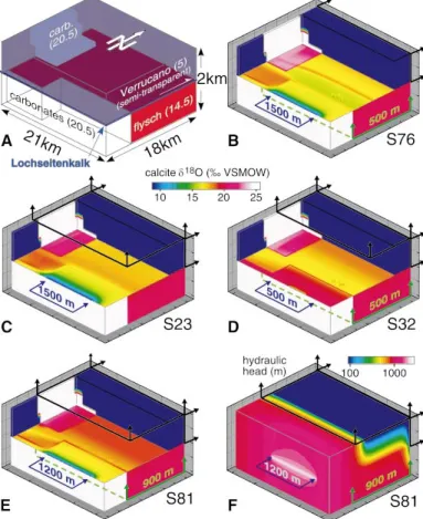
Four representative simulations are shown in Figure 2 (B–F). A more complete set of 15 additional simulations is available1. Boundary
conditions for the fluid-flow simulations consist of prescribed hydraulic heads at inflow boundaries, a lower hydraulic head equal to 0 m at outflow boundaries, and impermeable boundaries elsewhere (Fig. 2, B– F). For the transport simulations, the isotopic composition of fluids is imposed at inflow boundaries, and a zero-dispersive flux is assigned at outflow boundaries. Two types of incoming fluids are distinguished. At the southern inflow boundary (blue arrows in Fig. 2, B–F), a basement-derived fluid X has ad18O of 4.5‰. A flysch-derived fluid Y with an
initiald18O of 14‰ is infiltrating at the bottom in the northern part of
the model domain (green arrows in Fig. 2, B–F). In a first simulation (Fig. 2B), a hydraulic head of 1500 m is specified for fluid X, while a lesser head of 500 m is specified for fluid Y. Outflow boundaries are specified at the northern end of the Lochseitenkalk and overlying Ver-rucano. For a comparison of model results with observations (Fig. 1), the model domain has been cut open along the thrust surface, at 1 km vertical depth (Fig. 2B). Our first model reproduces a steep gradient ind18O values in the south, similar to the observed trend. Farther north,
however, this first simulation produces values that are too depleted in
18O with respect to observations. This depletion results from downward
advection of fluids from the Verrucano into the thrust zone and under-lying flysch. An influence of upward flow of fluid Y is seen only in the northernmost part of the model, where it yields high values (19‰) for the Lochseitenkalk. We conclude that flow boundary conditions and/or hydraulic heads are inadequate to reproduce the observed ox-ygen isopleths along the thrust (Fig. 1B). In particular, the specified head of 500 m at the base of the flysch is clearly too small to force a sufficient upward flow against the hydraulic head of 1500 m imposed for thrust-parallel flow at the rear.
In a second simulation (Fig. 2C), we tried to force an upward flow
1GSA Data Repository item 2002105, Additional representative fluid-flow
simulations, is available from Documents Secretary, GSA, P.O. Box 9140, Boul-der, CO 80301–9140, [email protected], or at www.geosociety.org/pubs/ ft2002.htm.
Figure 2. A: Block diagram showing three-dimensional configuration of different rock masses used for fluid-flow modeling. Numbers in parentheses give initiald18O value (in per mil relative to Vienna stan-dard mean ocean water [V-SMOW]) of pore fluids in isotopic equilib-rium with surrounding rocks. B–E: Four representative numerical simulations (S numbers) of fluid flow and isotopic exchange be-tween fluid and rock. Color coding illustrates calcited18O patterns obtained after 500 k.y. of simulation time. Blocks have been cut open along thrust fault at 1 km depth in order to visualize regional-scale north-south isotopic front; compare this level with map shown in Figure 1B. Fluid sources are indicated with arrows pointing into block; numbers are hydraulic heads. FluidX (in blue) is linear source along thrust; fluidY (in green) is planar source at base of model. Black arrows indicate geometry of drains (0 m head). F: Three-dimensional configuration of hydraulic heads resulting from config-uration of sources and drains of preferred simulation shown in E.
TABLE 1. MATERIAL PROPERTIES
Lithology Kxx Kyy Kzz f Xkk d18Orock
Verrucano 0.0309 0.0309 0.01 0.03 1E-7 10.5
Flysch 0.15 0.15 0.15 0.06 1E-6 19
Lochseitenkalk 6(5) 1 0.5 0.05 1E-4 26
Footwall carb. 0.01(0.02) 0.01(0.02) 0.005 0.03 1E-7 26
Hanging wall carb. 0.03091 0.03091 0.0309 0.04 1E-6 26
Note: Physical properties of each lithologic unit used for numerical simulations are listed. Numbers in brackets have only been used for simulation S32. The Glarus thrust, i.e. the Lochseitenkalk calc-mylonite, is modeled as a high-conductivity plane. Kxx, Kyy, and Kzz are hydraulic conductivities in the x-, y-, and z- direction,
respectively;fis porosity; andXkkis the inverse rate of reaction. The initiald18O
value of each rock unit is given in per mil relative to V-SMOW (Vienna standard mean ocean water) isotope standard (Burkhard et al., 1992).
in the northern part of the model by adding a planar drain (head5 0 m) at the top boundary from 6 to 18 km north. As expected, this second simulation yields identical isopleths in the southern half of the model (Fig. 2C). Farther north, however, simulation 2 successfully forces an upward flow across the thrust, leading to uniformd18O values in the
Lochseitenkalk above flysch. This depletion is too small, however, and we conclude that the upward-flow component is still too weak in com-parison with the thrust-parallel flow.
In a third simulation (Fig. 2D), the hydraulic head of fluid X is reduced to 500 m. The inflow boundary for fluid Y remains unchanged. Outflow boundaries are similar to those in the previous simulation (Fig. 2C), but the drain at the top is slightly reduced in size, now located between 10 and 18 km north. This third simulation produces d18O
values that are generally too high and no marked gradient in the south, apparently because fluid X equilibrates with the underlying carbonates by advection and/or dispersion. Farther north, Lochseitenkalk displays increasingly higherd18O values up to 18‰, reflecting a
northward-increasing influence of fluid Y.
The simulation that best reproduces the observed18O isopleths is
shown in Figure 2E. The hydraulic head of fluid X is fixed at 1200 m; fluid Y at the base is set to 900 m. Planar fluid drains are located at the north wall and top of the domain. The resulting hydraulic-head distribution for this last simulation, shown in Figure 2F, indicates thrust-parallel flow in the south and upward flow in the north. This flow pattern successfully leads to oxygen isotope isopleths similar to the observed trends (Fig. 1B).
In addition to changing the configuration of sources and drains, we have also varied porosities, reaction rates, and hydraulic conduc-tivities in order to test their influence on the resulting 18O isopleths.
These parameters have a strong influence on the time needed to reach a certain amount of isotopic depletion and advance of isotopic fronts. The general patterns of oxygen isopleths, however, are not sensibly affected. Thrusting and associated fluid flow at Glarus probably was active longer than the 500 m.y. model time used in our simulations. We possibly accelerated our simulations by assuming slightly too high reaction rates, porosities, and/or hydraulic conductivities. Different val-ues of permeability have also been tested for each lithology. In order to develop an isotopic front in the south, the permeability of Lochsei-tenkalk mylonites has to be at least 100 times higher than that of the overlying Verrucano.
DISCUSSION AND CONCLUSIONS
Simulations presented here provide new evidence for fault-parallel fluid flow along southern parts of the Glarus thrust. Observed patterns of isotopic depletion within the calc-mylonites lining this major thrust fault can only be simulated by strongly channelized flow along a high-permeability conduit. Steep gradients in vertical isotope profiles across the thrust (Fig. 1, C and D) are due to dispersion and minor cross-thrust advection. Such a flow regime has been assumed before in order to calculate time-integrated fluid fluxes in one dimension from the shape of the isotopic front observed in a north-south direction (Bow-man et al., 1994). Our three-dimensional flow and isotope-exchange simulations confirm this scenario and provide additional constraints on fluid-flow parameters. One of the most important findings is the high contrast in hydraulic conductivities between the thrust fault and adja-cent footwall and hanging-wall rocks. Ratios of.100:1 are needed in order to ensure strong fluid channeling along the thrust and to prevent dilution by vertical infiltrations from or to the hanging wall and foot-wall. An additional condition necessary for the development of the observed isotopic fronts is an important fluid source in the hinterland and/or footwall of the thrust system. This fluid source X is also needed to develop and maintain a high hydraulic head over a time span longer than 500 k.y. The most likely fluid sources are highly evolved for-mation brines and metamorphic waters expelled from European base-ment, which was subducted to, squeezed, and metamorphosed at mid-crustal levels below the advancing alpine thrust wedge (Marquer and Burkhard, 1992). Farther north, the origin of fluid source Y is more easily located within a thick section of flysch in the footwall of the Glarus thrust.
Compaction and prograde metamorphism of these clay-rich sedi-mentary rocks provide ample potential for large fluid quantities to be expelled. A thick zone of isotopic alteration extending;10 m upward into the Verrucano hanging wall requires a massive upward component of fluid flow in northern parts of the Glarus thrust (Badertscher, 2001). Our fluid-flow and isotopic exchange simulations only succeed in cre-ating such isopleth patterns with the introduction of a sizable drain in the north. To explain the marked change between south and north, we propose a situation in which the Glarus thrust evolved across the im-permeable cap of the advancing alpine thrust wedge. This hypothesis is compatible with the high hydraulic head differences required in our simulations. Fluid sources located in the south and in the footwall are expected to be within the lithostatically pressured fluid regime, whereas drains at the top and in the north are thought to be in the hydrostatic regime. Complex interactions between ongoing thrusting deformation and strong, transitory fluctuations in the local fluid pressure are ex-pected in this situation. At this stage, our ‘‘steady-state,’’ large-scale fluid-flow simulations are incapable of taking such details and fluctu-ations into account. Structural and microstructural observfluctu-ations of mul-tiple generations of veins and their ductile overprint within the Loch-seitenkalk mylonites provide strong evidence for the alternate activity of ductile and brittle deformations. The latter were most likely trig-gered by the repeated buildup of high fluid pressures within the fault zone (Badertscher and Burkhard, 2000) in some sort of seismic-pumping behavior (Sibson, 1990). Similar observations have been made at the McConnell thrust of the Canadian Rockies, the Hunter Valley thrust of the Appalachians (Kennedy and Logan, 1998), and the Gavarnie thrust of the Pyrenees (McCaig et al., 1995). The situation of these so-called continental thrust faults bears some resemblance to that of their so-called oceanic counterparts, such as Barbados or Nan-kai, where in situ observations of the fluid-flow behavior could be made (Henry, 2000).
Saffer and Bekins (1999) proposed a predominance of channelized fluid flow along thrust faults in deeper parts of accretionary wedges and a more diffuse fluid seepage at shallower depths. The transition between these two fluid regimes seems to coincide with the brittle-to-ductile boundary, and rapid upward escape of deep-seated fluids is strongly related to seismic activity (Saffer and Bekins, 1999). Detailed geochemical and microstructural observations and increasingly sophis-ticated geochemical modeling in one-dimensional and new three-dimensional fluid-flow and geochemical exchange simulations, as pre-sented here, provide a strong set of arguments for a similar scenario in the fossil Glarus thrust of the eastern Swiss Alps. We propose that this thrust owes its extreme strain localization to an intimate relation-ship between deformation and fluid flow along the thrust.
ACKNOWLEDGMENTS
This research was funded by Swiss National Science Foundation grants 20-50535.97 and 20-56920.99. We thank David Kirschner and David Ferrill for constructive reviews.
REFERENCES CITED
Abart, R., and Pozzorini, D., 2000, Implications of kinetically controlled min-eral-fluid exchange on the geometry of stable-isotope fronts: European Journal of Mineralogy, v. 12, p. 1069–1082.
Badertscher, N.P., 2001, Deformation mechanisms and fluid flow along the Gla-rus overthGla-rust, eastern Helvetic Alps, Switzerland [doctoral thesis]: Neu-chaˆtel, Switzerland, Neuchaˆtel University, 161 p.
Badertscher, N.P., and Burkhard, M., 2000, Brittle-ductile deformation in the Glarus thrust Lochseiten (LK) calc-mylonite: Terra Nova, v. 12, p. 281–288.
Baker, J., and Spiegelman, M., 1995, Modelling an infiltration-driven geochem-ical front: Earth and Planetary Science Letters, v. 136, p. 87–96. Baumgartner, L.P., and Rumble, D., 1988, Transport of stable isotopes: 1.
De-velopment of a kinetic continuum theory for stable isotope transport: Con-tributions to Mineralogy and Petrology, v. 98, p. 417–430.
Beaudoin, G., and Therrien, R., 1999, Sources and drains: Major controls of hydrothermal fluid flow in the Kokanee Range, British Columbia, Canada: Geology, v. 27, p. 883–886.
Bickle, M.J., and McKenzie, D., 1987, The transport of heat and matter by fluids during metamorphism: Contributions to Mineralogy and Petrology, v. 95, p. 384–392.
Bowman, J.R., Willett, S.D., and Cook, S.J., 1994, Oxygen isotopic transport and exchange during fluid flow: One-dimensional models and applications: American Journal of Science, v. 294, p. 1–55.
Burkhard, M., Kerrich, R., Maas, R., and Fyfe, W.S., 1992, Stable and Sr-isotope evidence for fluid advection during thrusting of the Glarus nappe (Swiss Alps): Contributions to Mineralogy and Petrology, v. 112, p. 293–311. Henry, P., 2000, Fluid flow at the toe of the Barbados accretionary wedge
constrained by thermal, chemical, and hydrogeologic observations and models: Journal of Geophysical Research, v. 105, p. 25 855–25 872. Hunziker, J.C., Frey, M., Clauer, N., Dallmeyer, R.D., Friedrichsen, H., Flehmig,
W., Hochstrasser, K., Roggwiler, P., and Schwander, H., 1986, The evo-lution of illite to muscovite: Mineralogical and isotopic data from the Glarus Alps, Switzerland: Contributions to Mineralogy and Petrology, v. 92, p. 157–180.
Kennedy, L.A., and Logan, J.M., 1998, Microstructures of cataclasites in a limestone-on-shale thrust fault: Implications for low-temperature recrys-tallization of calcite: Tectonophysics, v. 295, p. 167–186.
Kirschner, D.L., Masson, H., and Sharp, Z.D., 1999, Fluid migration through thrust faults in the Helvetic nappes (Western Swiss Alps): Contributions to Mineralogy and Petrology, v. 136, p. 169–183.
Lassey, K.R., and Blattner, P., 1988, Kinetically controlled oxygen isotope ex-change between fluid and rock in one-dimensional advective flow: Geo-chimica et CosmoGeo-chimica Acta, v. 52, p. 2169–2175.
Manning, C.E., and Ingebritsen, S.E., 1999, Permeability of the continental crust: Implications of geothermal data and metamorphic systems: Reviews of Geophysics, v. 37, p. 127–150.
Marquer, D., and Burkhard, M., 1992, Fluid circulation, progressive deformation and mass-transfer processes in the upper crust: The example of basement-cover relationships in the external crystalline massifs, Switzerland: Journal of Structural Geology, v. 14, p. 1047–1057.
McCaig, A.M., 1989, Geology: Fluid flow through fault zones: Nature (Lon-don), v. 340, p. 600.
McCaig, A.M., Wayne, D.M., Marshall, J.D., Banks, D., and Henderson, I., 1995, Isotopic and fluid inclusion studies of fluid movement along the Gavarnie thrust, central Pyrenees: Reaction fronts in carbonate mylonites: American Journal of Science, v. 295, p. 309–343.
O’Neil, J.R., Clayton, R.N., and Mayeda, T.K., 1969, Oxygen isotope fraction-ation in divalent metal carbonates: Journal of Chemical Physics, v. 51, p. 5547–5558.
Rahn, M., Mullis, J., Erdelbrock, K., and Frey, M., 1995, Alpine metamorphism in the North Helvetic flysch of the Glarus Alps, Switzerland: Eclogae Geologicae Helvetiae, v. 88, p. 157–178.
Saffer, D.M., and Bekins, B.A., 1999, Fluid budgets at convergent plate mar-gins: Implications for the extent and duration of fault-zone dilatation: Ge-ology, v. 27, p. 1095–1098.
Schmid, S.M., 1975, The Glarus overthrust: Field evidence and mechanical model: Eclogae Geologicae Helvetiae, v. 68, p. 247–280.
Sibson, R.H., 1990, Conditions for fault-valve behaviour, in Knipe, R.J., and Rutter, E.H., eds., Deformation mechanisms, rheology and tectonics: Geo-logical Society [London] Special Publication 54, p. 15–28.
Therrien, R., and Sudicky, E.A., 1996, Three-dimensional analysis of variably-saturated flow and solute transport in discretely-fractured porous media: Journal of Contaminant Hydrology, v. 23, p. 1–44.
![Figure 1. A: Cross section of Glarus Alps in eastern Switzerland. B: Contour map of mean d 18 O composition (in per mil relative to Vienna standard mean ocean water [V-SMOW]) of Lochseiten calc-mylonite horizon obtained by kriging between sample sites (wh](https://thumb-eu.123doks.com/thumbv2/123doknet/14933448.665400/2.918.71.593.53.413/switzerland-contour-composition-relative-standard-lochseiten-mylonite-obtained.webp)