2
Planting trees and seeing them grow seems to me a great happiness. The peace wich our souls are hungry for,
the peace that all men caress as supreme good in a futur world, the peace that I can only enjoy here, far from the noise of cities!
Giuseppe Garibaldi”
Written accompanying the ancient Italian stone pine (Pinus pinea L.). The flag tree or banner tree, carved and anemorphosed by the sea winds, that General Garibaldi planted in Island of Caprera, during February 16-1867, the day of the birth of Clelia, the first of the children he had since his last marriage with Francesca Armosino.
“Planter et voir grandir des arbres me procure une grande joie.
La paix que nos âmes envient,
la paix que tous les hommes caressent comme un bien suprême dans un monde futur,
je ne peux que la esse ti u i ue e t i i, loi du uit de la ville!”
Giuseppe Garibaldi
É it ui a o pag e l’a ie Pi Pig o (Pinus pinea L.). Arbre drapeau, sculpté et anemomorphosé par les vents marins ; que le Généal Ga i aldi a pla té su l’Île de Caprera lors du 16 février 1867, la date de naissance de Clelia, le premie des e fa ts u’il a eu de so dernier mariage avec Francesca Armosino.
"Il piantare e veder crescere gli alberi mi sembra una grande felicità.
La pace che è fame delle anime nostre, quella pace che tutti gli uomini carezzano come bene supremo in un mondo futuro,
io non la gusto che qui, lontano dal fracasso delle città!
Giuseppe Garibaldi"
S itto he a o pag a l’a ti o Pino domestico (Pinus pinea L.), a bandiera, scolpito e anemorforsato dai venti marini, che il Generale Garibaldi piantò a Caprera il 16 febbraio 1867, giorno della nascita di Clelia, primogenita dei figli avuti dal suo ultimo matrimonio con Francesca Armosino.
3
INDEX
1. INTRODUCTION ... 6
1.2 Preamble... 6
1.3 The CarHAB Project framework ... 7
1.4 Research questions and hypotheses ... 10
2 - GENERAL CONCEPTS AND PRINCIPLES ... 12
2.1. History and state of knowledge in phytosociology, and landscape phytosociology ... 12
2.1. Vegetation and mapping principles ... 14
2.1.1. Phytosociology, plant map and the dynamico-catenal approach ... 14
2.1.2. Terroir and Territory biogeographical definition ... 17
2.1.2.1. Large territories ... 17
2.1.2.2. Small territories ... 18
2.2 Vegetation mapping of plant complexes ... 19
2.2.1 Plant communities between small and large scales ... 19
2.2.2 Integrated plant mapping approach ... 20
2.2.3 Bio-evaluation, biodiversity and heritage assessment of the vegetation ... 20
2.3 Principles of geography, morphology and other ecological aspects of Estuaries... 21
2.3.1 Main geographical and abiotic aspects ... 21
2.3.2 Morphological types ... 26
2.3.3 General ecological and synecological aspects ... 35
2.3.3 Global environmental risks, natural resources, human ecology, land uses, and threats ... 39
3. STUDY AREA ... 40
3.1. Atlantic French Estuaries ... 40
3.1.1. General description ... 40
3.1.1.1. Location and distribution ... 40
3.1.3 Principles and State of knowledge on vegetation ... 41
4
3.2 General description per Estuary ... 44
3.2.1 Largest estuaries ... 44 3.2.1.1 Gironde ... 44 3.2.1.2 Seine ... 45 3.2.1.3 Loire... 45 3.2.1.4 Somme ... 46 3.2.1.5 Charente ... 47 3.2.2. Smaller estuaries ... 48 3.2.2.1. Brittany estuaries ... 48 3.2.2.2 Other estuaries ... 53
3.2.2.2.1 The Hâvres of Cotentin (Lower Normandy) ... 53
3.2.2.2.2 Estuaries from Picardie and Nord-Pas-de-Calais ... 54
3.2.2.2.3. Other estuaries of Aquitaine ... 55
4. METHODOLOGY ... 57
4.1. Main bioclimate, biogeography and abiotic aspects ... 57
4.1.1. Worldclim ... 64
4.1.2. Ombrothermic diagrams ... 65
4.2. Plant landscape methodology ... 65
4.2.1 Methodological approach to define vegetation series and vegetation series complexes ... 65
4.2.2. Potentiality, phytodynamics and vegetation tendencies analysis ... 68
4.2.3. Field relevés ... 69
4.2.4. Transect pointing and spatialisation ... 71
4.3. Cartography, generalization, modeling and extrapolation ... 71
4.3.1. Time and surface scale ... 71
4.3.2 The scale problem and resolution factor ... 72
4.3.3. Sampling: choice of test points, relevés, synrelevés/géosynrelevés, and transects . 73 4.3.4. Mapping series and geoseries according to the dynamico-catenal approach ... 73
4.3.5. Semiotics: the choice of colors in plant mapping ... 74
5
5. DATA ANALYSIS AND RESULTS ... 77
5.1. Theoretical Ecological compartments scheme of an estuary ... 77
5.2. Bioclimate mapping ... 84
5.2.1. Bioclimatic map of Atlantic phytoregion ... 84
5.2.2. Bioclimatic characterization of selected estuaries ... 88
5.2.3. Ombrothermic diagrams of estuaries ... 92
5.3. Phytosociology ... 97
5.3.1. Table of associations, and plant groupments ... 97
5.3.2. Description of plant associations ... 105
5.4. Synphytosociology and Geosynphytosociology ... 161
5.4.1. Series description ... 161
5.5. Plant communities’ diversity and organization ... 191
5.6. Vegetation models ... 226
5.6.1. Vegetation Series maps ... 226
5.6.1.1. Aulne estuary ... 229
5.6.1.2. Laïta estuary ... 233
5.6.1.3. Loire estuary... 237
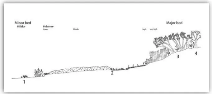
5.6.2. Transects from minor to major River bed ... 242
5.7. Theoretical Series/Catenas scheme of an estuary ... 242
6. DISCUSSION ... 247
6.3.4. Plant landscape representation at smaller scale ... 271
7. CONCUSION AND OUTLOOKS ... 275
ACKNOWLEDGEMENTS ... 279
CITED LITERATURE: ... 282
ANNEXES ... 320
Others PhD experiences………...……….320
List of figures and tables………...………329
Extendes summaries………...336
In French language………...………...336
In Italian language………..………345
6
1.
INTRODUCTION
1.2 Preamble
‐urope’s natural habitats are increasingly deteriorating and related wild species are threatened. This negative trend is the result of our needs, linked to the society development issues (economic growth, urbanization, deforestation, human population growth, pollution and soil uses). This, although the development of many national and international policies on environmental issues that let us to pay more attention to the environment also in urban and territory planning (CLERGEAU & BLANC, 2013); or to the point that the same areas could undergone under several protection measures at the same time (LALANNE, 2017).
Policies and actions evidently are not always effective due to the incomplete knowledge, bias, or exploitation of the environmental conservation issues.
This makes possible to understand how the amount of protection measures not always make the difference. The most important value is the quality (efficiency and effectiveness), not the quantity of these measures per surface. The quality of protection measures depends to the evolution of the scientific concepts and point of views; and it is propaedeutic to the knowledge of the territory. To foster the quality of these measures (policies, actions, projects, etc.) it is strictly necessary to improve the knowledge of the territory (observations, and descriptions) by the study of environment issues and related biodiversity issues: i.e.: distributions, impacts, status, heritage, productivity, threats, dynamics (natural, anthropogenic and mixed), and monitoring the effects of the measures carried out.
The “know-how to better manage” motto in vogue especially from 7Ńs, remains a valid concept, since the success in the natural environments management can only be achieved looking for an increasing knowledge of the environment (BIORET, 2003) as underlined by LALANNE (2017). The notion summarized by this motto was developed after the setting up of the protected areas institution, landscape conservation policies, biodiversity protection actions, and by some international agreement like the Ramsar convention (1971), the “Birds” EU
Directive (1979) the EU Natura 2000 network and the related “Habitats” Directive (1992).
Since the early 2000s, in the framework of the implementation of the Water Framework Directive. (2000/60 / EC), the study of Macrophytes was recognized as environmental evaluation tools by the European community, underlining the importance of plants and vegetation as bio-indicators.
These, combined with further initiatives impose to the European community member states a periodic evaluation of the conservation status of populations, species and habitats of Community interest: increasing the needs to know the Landscape and the environment characteristics, together with the needs to describe the territory biodiversity. This, also in function of land use changes and climate changes (global changes) monitoring.
Actually, France does not have a map of the natural and semi-natural vegetation covering its whole territory (LALANNE, 2017). For that reason, French government decided to implement the knowledge acquisition on natural and semi-natural vegetation, by a national mapping and research program for natural and semi-natural vegetation called CarHAB, launched by the Ministry of Ecology (LALANNE, 2017). This mapping is indispensable to improve the evaluation of the status (preservation vs. anthropization) of habitats, especially them of EU Community interest (European obligation within the framework of the Habitat directive). The knowledge of ecological gradients, the ecosystems complexity and dynamics, will be very useful to better asses their services, the impact human activities, the relevance of protected areas network, the
7
efficacy of environmental policies, and the elaboration of the national red lists of habitats (LALANNE, 2017).
Estuaries represent a very important system for human uses, and they are very important for their biodiversity issues. Generally, these environments are considered of very high importance following “Birds” and “Habitats” ‐U directives together within the “Ramsar convention”. National and local administrations improved these directives and conventions by laws, regulations, restrictions, prohibitions and actions – following the different realities, peculiarities and risks. Estuaries are commonly considered very rich in species, very productive in biomass and as important sources of ecosystem services (MUCHIUT et al., 2008).
Estuarine environments are characterized by significant tides, and currents that could be very strong. Estuaries generally include a wide mosaic of environments such as reed beds, salt marshes, forests, fens, meadows, aquatic communities, mud flats, shoals, sandbanks, gravel or pebbles bars, freshwater marshes, pools...
The estuaries undergone over the century under some changes following the human pressure and human needs. In fact, some estuaries shelter ports, cities, industrial areas or where transformed by barrages, canalization, deforestation, reclamation, soil uses... These changes often limited or threaten the services and the functionality of these ecosystems, altering the water quality (i.e.: salt, oxygen and nutrients contents), influencing the water dynamic, the estuarine functionality, the species presences and the vegetation expression.
Estuarine ecosystems are degrading almost everywhere in the World (LOTZE et al., 2006); following the Global critical status of water bodies concerning Seas and Oceans, large river bottom valleys and even mountain streams, as shown by the WWF report in collaboration with the University of Vienna, entitled: "Save the Alpine Rivers - 2014". Estuaries are more or less constantly traversed by waters contaminated by various pollutants from micro to macro types, and they are not only influenced by local conditions, but also by pollutants carried by Oceans and rivers flows (BROWNE et al., 2010).
In this context, some researches were carried out about estuarine systems, and some phytoassociassions and plant landscape portions were described; but a systemic knowledge and a wider study on these plant landscape systems was never carried out before in France.
For all that, these ecosystems have been chosen within the CarHAB pilot study areas, as “‐stuaries project” trying to fill these gaps and to provide a first scientific support for a in depth and wider knowledge on estuaries plant landscape; and to improve a common shared approach and methodology to study estuarine ecosystems and related vegetation survey.
This Thesis titled «Plant landscape and models of French Atlantic estuarine systems» was financed by the French ministry of Environment within the French National program of natural and semi-natural habitats cartography (CarHAB, convention 2100992970); and it was realized under an international (Italy-France) PhD Study co-tutorship agreement between Università degli Studi di Camerino [University of Camerino, Italy] and Université de Bretagne Occidentale (Brest, France) [University of Western Brittany, Brest, France].
1.3
The CarHAB Project framework
The French Ministry of the Environment, Energy and Sea (MEEM) in collaboration with the National Natural History Museum, Natural Heritage Service (MNHM-SPN), set up the National Inventory of Natural Heritage which targets several objectives ensuring the development of a National reference bank on biodiversity knowledge, based on data of national
8
programs from different types, including TAXREF (program for a taxonomic repository); HABREF (for habitat repository); and from NATURA 2000, ZNIEFF, red lists, habitats lists, vegetation prodrome, action plans, plant and vegetation inventories, habitat status (etc.), to be integrated into a nature and landscape information system (SINP). In this context, as part of the National Strategy for Biodiversity (SNB) 2011-2020, the French Ministry of the Environment initiated a program on mapping land habitats called “Cartographie nationale des habitats terrestres (CarHAB)”, in partnership withŚ ‑ederation of National Botanical Conservatories (FCBN), National Institute of Geographical and Forest Information (IGN), National Science and Technology Research Institute for the Environment and Agriculture (IRSTEA), National Natural History Museum (MNHN), French Phytosociological Society (SFP), University of Western Brittany (UBO, Géoarchitecture Lab), Clermont-Auvergne University (UCA, UNIV‐G‐), “Jean Monnet” University of Saint-Étienne (ISTHME Lab), Univeristy of Upper
Brittany “Rennes 2”, (L‐TG Lab), Avignon University (IM‐P Lab) 1,2,3,4.
Europe has a long and well-documented tradition of vegetation science and mapping. In this context, France played a long history, following the Phytosociological Braun-Blanquet (or Zurich-Montpellier) school. The potential natural vegetation map of France at a 1:200000, a significant work from the second half of the XXth century, not strictly follows a phytosociological methodology. In recent years most French habitat and vegetation maps were produced at regional or local scale but a wider overview of habitats in a National scale is more difficult to have. The production of vegetation maps has been significant in France however, the actual vegetation maps have not been updated (LEGUÉDOIS et al., 2011).
The 1992 European habitat directive fostered the attention on habitats of community interest, increasing the needs on vegetation distribution and conditions knowledge; fostering also the habitats and vegetation surveys, monitoring and mapping. The CarHAB project follows this tradition to upload and trying to redefine a vegetation map of France at a 1:25 000, following the phytosociological and land phytosociological approaches, in order to obtain more information on vegetation distribution and spatialization of plant communities and habitats. This project aims also to discuss and develop a more shared methodology, evaluating the state of the art, proposals and outlooks.
Vegetation patterns, reflects environmental conditions and human activities, characterizing the landscape, habitats, the land conservation status. The CarHAB approach is based on an inductive and semi-deductive method that describes the vegetation systems.
This program is based on the “dynamic phytosociology” and the “landscape
dynamico-catenal” (or dynamic catenal) approaches. These subjects have the advantage of a systematic and integrated analysis of the biotic and abiotic components and the complexity of the ecological systems of the plant landscape (GÉHU, 2006). Preliminary research program steps consist to review the actual knowledge, experiences and practices on plant mapping, vegetation studies and Phytosociology science, to establish a shared typology and to obtain a vegetation map of the vegetation series of France. CarHAB research program, combining the actual and potential vegetation represents a flagship program for the French national biodiversity strategy and to develop the European Habitats Directive, together with other national, local and international programs on Plants, Vegetation, Habitats, Cartography, Landscape and Soil uses purposes. 1 https://inpn.mnhn.fr/actualites/lire/1241/ 2 http://www.trameverteetbleue.fr/outils-methodes/donnees-mobilisables/projet-carhab 3 http://letg.cnrs.fr/article869.html 4 http://m.irstea.fr/linstitut/nos-centres/grenoble/emgr/qualite-indicateurs-et-evaluation-environnementale-des
9
According to ICHTER et al., (2017) the methodology adopted for this project consists in a combination of practices and bibliographical review (state of the art), and evaluating also the international experiences from other countries. CarHAB methodology was chosen after taking into account the following issues:
• any comprehensive overview of wide vegetation-habitat mapping in Europe is available (large surfaces maps with large geographical scale, in which the denominator is small);
• difficulties to access some literature (grey literature, unpublished works, un-available copies, language issues…)ś
• according to MOLNÁR et al. (2007), the practices and methodological issues are rarely
standardized, discussed or shared within the scientific world and protected areas or land managers.
The CarHAB program organization was validated by a working group composed by representatives of CarHAB technical committee and the European Topic Centre on Biological Diversity (ETC-BD). For these issues a national working group has been established5 in order to rewiew bibliography, the actual status of knowledge on the subject; and to discuss on definitions, methodology, expertise, publications, test advancements, and to ensure the coordination between research project partners (CHALUMEAU & BIORET 2013, 2017; ICHTER et
al., 2014; CHOISNET et al., 2016, 2018; LALANNE, 2017; MARCENO’, 2017; BIORET et al., 2018). Two reviews carried out (ICHTER et al., 2012, ICHTER et al., 2015) bring together the European experiences of vegetation mapping and methodologies that use the phytosociological and synphytosociological approaches.
The CarHAB program follow three main components:
- tools (typology, methodology, definitions, modeling, standardization, physiognomic and ecological "white background");
- cartographic methodology (mapping, synthesis of mapping experiments, field tests);
- semiology, informatics systems and geographical information systems (GIS).
The French Botanical Conservatories network started some tests (CHOISNET et al., 2014a,b,c;
ISENMANN and SANZ, 2015; LUQUE et al., 2015; PANAÏOTIS et al., 2015; CATTEAU et al., 2016). Other studies were realized to set up a methodology in different areas and biogeographic contexts on larges areas:
- Armorican Massif, by Chalumeau (CHALUMEAU et al., 2014, 2018; CHALUMEAU, 2018);
- Corsica, by Delbosc (DELBOSC, 2015, 2016; DELBOSC et al., 2014, 2015, 2016, 2017a,b, 2018a,b,c; BIORET et al., 2017; TANNÉ et al., 2018);
- French Channel-Atlantic coastal vegetation by Demartini (DEMARTINI et al., 2017; DEMARTINI, 2016; BIORET and DEMARTINI, 2013, 2014; BIORET et al., 2014, 2015a,b, 2016, 2017);
- Temperate mountain range from Limagne to the “Chaîne des Puys”, by Roux (ROUX et
al., 2017; ROUX, 2017).
- Steppic vegetation of the Crau plain, by Courtial (in progress).
- Mediterranean vegetation of the Associations and sigmassociations of the Bas-Vivarais (Ardèche), by Choisnet (CHOISNET et al., 2014, 2018).
- French Atlantic Estuaries by Cianfaglione (CIANFAGLIONE & BIORET, 2015, 2017; CIANFAGLIONE et al., 2016).
10
1.4
Research questions and hypotheses
The aim of this Thesis is to study the vegetation and Plant Landscape of Estuarine Atlantic systems of France, trying to understand the functioning and the plant distribution patterns. The goal of this work is to develop a spatio-temporal predictive model based on actual and potential vegetation, using the dynamico-catenal approach; trying to carry out a theoretical common model of functioning and ecological gradients of estuaries. This, in order to make a basis to improve estuarine system classification, the related geography and ecological studies, and to help the monitoring and assessment of land uses and the global changes.
Estuaries represent a very complex ecosystems recognized as crucial or important at some levels: biodiversity, natural resource exploitation, infrastructures, global changes issues, social themes and economic topics - at local, national and international scales. Estuaries have been chosen between the pilot study site within the CarHAB research project framework, for these reasons and for the peculiarities of its vegetation. The evolution of the environment-society interactions, and the related changes issues, are fundamental to understand the possible trajectories in the vegetation dynamic, estuaries functioning and natural resources management (including landscape, biodiversity, water and soil uses). The combination of ecological and society visions raises acutely the questions of the functioning and the management of these ecosystems (i.e.: agro-sylvo-pastoral, urbanization, industrialization, conservation, hunting and fishing purposes). Following these purposes, estuarine ecosystems were mostly subjected to human activities for centuries, deeply influencing the geographical characteristics as well as the plant communities with uses sometimes contraposed or with colliding interests.
This work aims to understand how the dynamico-catenal phytosociology can contribute to characterize the structure, the determinism, the dynamics and the distribution of vegetation series and geoseries of French estuaries. The aim of this Thesis is also to study the French Atlantic estuarine ecological and geographical system to deepen the vegetation knowledge of these ecosystems, to contribute at the French vegetation map, and to set up a synphytosociological methodology for estuarine systems, for which no equivalent research work had been carried out previously in France.
The scientific approach and related concepts applied to the study area are discussed, in the advantage of representing three levels of vegetation organization: plant community (plant association), dynamic (series) and plant landscape (geoseries) integrated following geographical and ecological variables defining patterns like Phytocoenoses, plant association, Tessella, Series, Catena and related complexes following the spatio-temporal scale.
This, in order to the following main research questions:
- Is it possible to define a general common model of a estuary ecological gradients,
functioning and plant landscape?
- What are the most important geographical and ecological characteristics influencing
the plant patterns in estuaries?
- How vegetation traits, distribution and models could help to classify estuary types?
In addition, this work aims to foster the French National vegetation map, and to answer to the already mentioned problematic and questions, based on the dynamico-catenal (syn)phytosociological science (DELBOSC, 2015; DEMARTINI, 2016; ROUX, 2017), contributing to the shared theoretical and methodological discussion on bibliography, experiences,
11
definitions and practices within the CarHAB network. Trying to see also how could phytosociological and synphytosociological methods and concepts be useful in limonology, landscape and habitats studies, and to answering the previous questions.
The plant mapping work is carried out, with a double purpose: surfaces evaluation and chorology study based on sigmetal and geosigmetal units. All of these elements aim to improve the understanding of the structural patterns and the dynamics of Estuarine vegetation landscapes.
In France, most of the estuarine vegetation types were being described until now, with some exception concerning ruderal and segetal vegetation, which remain less studied (GAMISANS, 1975; DE FOUCAULT, 1984, 2008; BOULLET, 1986; BARDAT et al., 2004; BIORET, 2010). Following the alteration of landscape and vegetation, we do not know the potential vegetation of some areas. Other areas, starts to show a possible potential vegetation only recently, after a lot of years or even centuries of soil uses stop or decreasing (i.e.: THEURILLAT,
1992; CHYTRÝ, 1998; CIANFAGLIONE, 2014; SENDER & MA LANKO, 2015; SENDER et al., 2017;
PEDROTTI, 2004, 2013, 2017; PERRIN et al., 2018). This open some more questions about actual potential vegetation:
- How secondary communities could contribute to characterize the vegetation series in any way, and at in any level?
- How much the actual vegetation communities are in balance with the natural or anthropic dynamics?
It is not always possible to know trajectories and balances due to the lack of certain available historical data, because land and soil are still too used on very large surfaces; or because landscape forms were heavily altered (polderization, reclamation, barrages, land filling, excavation, mining, canalization, pollution, urbanization, erosion, deforestation, desertification, species lost, species introduction…). If not otherwise specified, the figures and tables that follows are elaborated by the author.
12
2 - GENERAL CONCEPTS
AND
PRINCIPLES
2 _
2.1.
History and state of knowledge in phytosociology, and landscape
phytosociology
The 2010 recurrence and celebrations of the phytosociology centenary, was an opportunity to trace the history and the evolution of this science (BIORET, 2010; GÉHU, 2010a,b, 2014; PIGNATTI, 2010; BIONDI, 2011).
According to GÉHU (2011) vegetation sciences have their origins in the writings of
Alexander VON HUMBOLDT (1805), considered as being the founder of the vegetation science
for its descriptive analysis actually known of "Physiognomic" (or physionomic) type. He mentions, the Andean Cordillera landscapes, grouping plants communities in “societies” distributed attitudinally, according to the climatic gradients. In this context, von Humboldt was among the first scientists to recognize the ecological gradients, where species are replaced or altered in form along environmental gradients, such as a “cline” forming along a rise in elevation.
This “primordial” physiognomic approach tends very quickly to integrate two disciplinesŚ the phytogeography (FLAHAULT, 1901) and the plant ecology (REITER, 1885). From this multidisciplinary context, in ń8ř6, J. Paczoski replace the word “‑lorologie”, that he had
created in ń8řń, by that of “Phytosociologie” (DASZKIEWICZ, 2004).
Geographers, botanists, ecologists, geographers, cartographers and biologists have during this period discussed, evolved and placed strong bases on the sciences of vegetation and phytosociology. Between them we can mention: Beck, Binz, Blanc, Brunier, Cayer, Clements, Combres, Drude, Diels, Engler, Gadeceau, Ganong, Geiger, Ghiridon, Gradmann, Graebner, Grisebach, Harshberger, Hardy, Jaccard, Krassnoff, Leeuw, Litwinoff, Ludwig, Moss, Oliver, Schouw, Schimper, Tansley, Warming and Smith (DE WILDEMAN, 1910).
The 1910s mark a turning point between the traditional phytogeography and the current phytosociology, with the definition of the plant association by Ch. Flahault and C. Schröter (GÉHU 2010a,b, 2014), and others proposals at the 1910 Brussels international congress of Botany (DE WILDEMAN, 1910), where the plant association was accepted as fundamental unit of the Synecology. The thesis of Braun-Blanquet (1915), focused especially on these study aspects representing a milestone in this science.
According to VAN DER MAAREL (1975), PIGNATTI (1995); PIROLA (1999); CRISTEA et al.,
(2004); GÉHU (2006) and UBALDI (2012) we can assume that the modern Phytosociology takes place with the works of Braun-Blanquet which increase and elaborate the conceptual, methodological and typological framework basis and its applications (BRAUN-BLANQUET, 1915, 1921, 1928), establishing a Phytosociological school leading the International Station of Mediterranean and Alpine Geobotany “Station Internationale de Géobotanique Méditerranéenne et Alpine (SIGMA)”Ś a research center founded by W.C. De Leeuw and R. Combes initiative, and diriged by Braun-Blanquet from its foundation in 1930, until its disappearance in 1980 (GÉHU, 2010a).
The ‐nglish version of this science name “Plant sociology” came from an American version of Braun-Blanquet book of Phytosociology (BRAUN-BLANQUET et al., 1932). This name was conceivably favoured by his collaborators of that book version (G.D. Fuller and H.S. Conard).
13
According to MOLINIER (1959, 1962) and BRAUN-BLANQUET (1964) the vegetation were approached statically for a long time, and the process of dynamics analysis rested on a fixist descriptive vision, often very subjective, emphasizing the difficulty of having a direct and complete perception of dynamics in plant associations during our lifetime, prejudices and others still critical issues (GUINOCHET, 1973; MUCINA, 2010).
From the 1970s, the context of classical Sigmatic Phytosociology (also called synphytosociology or landscape phytosociology) widens conceptually (RIVAS-MARTÍNEZ, 1976; BÉGUIN et al., 1979; TÜXEN, 1979; GÉHU & RIVAS-MARTÍNEZ, 1981; SCHWABE, 1989; GILLET et al., 1991; THEURILLAT; 1992a, 1992b; LAZARE, 2009; BIONDI et al., 2011). Works multiplied worldwide, to improve the knowledge of the vegetation, and also the ways to do, supported by various critics, additions, proposals and adjustments based on different experiences related to schools and study areas. According to PEDROTTI (2013), from the same period, studies of plant communities mainly take novelty within the integration of vegetation dynamics in time and space (TÜXEN, 1973, 1978; FALI SKI, 1986, 1998, 1999; FALI SKI & PEDROTTI, 1990). The dynamico-catenal phytosociology has made possible to better integrate vegetation dynamics by describing more finely the trajectories of vegetation series.
During this period, novelty concerned also a strongest integration of geographical, landscape, soil uses and ecological data, creating a lot of composite thematic maps types based on vegetation. PEDROTTI (2013) propose to distinguish the integrated phytosociological studies and maps in two types of integration:
- in time and space (the proper integrated phytosociological maps);
- in thematic issues (i.e.: ecological, social, agronomical, geographical, geologic, soil, climatic, zoology, and others info concerning biodiversity, populations, soil use, economy, urbanism, landscapes factors, environmental values, functions, structures...). The integration of these thematic in some way recall also the definition of “Géoarchitecture”ś term already in use previously but reopened by the architect “Le Corbusier” (Charles-Edouard Jeanneret-Gris) between ńř45 “Les Trois établissements humains” and ńř46 “Manière de
penser l'urbanisme” (SARAGOSA, 2015; PETRILLI A., 2006), when he decided to extend the scope of his preoccupations to spatial planning and the environment, going largely beyond architecture and urbanism. The task, in his eyes, required multiple skills ranging from the natural sciences to those of man and society.
We can consequently recall the “Geobotany” and “Geobotanical cartography” that
according to (PIGNATTI, 1976; PEDROTTI, 2Ńń3) respectively are “a broad science that deals
with the study of species and of vegetation communities in relation to the environment; it includes other, perhaps more familiar sciences, such as plant geography, plant ecology, and chorology, and phytosociology (plant sociology). Geobotanical cartography is a field of thematic cartography that deals with the interpretation and representation, in the form of maps, of those spatial and temporal phenomena that pertain to flora, vegetation, vegetated landscapes, vegetation zones, and phytogeographical units”. RÜBEL (ńřń2) first used the term “geobotanical cartography”, but only for the mapping of vegetation. Nevertheless, its meaning was amplified later to include the mapping of all phytogeographic, phytocoenotic and phytosociological aspects, as emphasized by PIGNATTI (1959), and FALI SKI (1991, 1993, 1999). The production of a geobotanical map represents the last stage in a cognitive process that begins with observations in the field and continues with the collection of sample data, interpretation of the phenomena observed, and their appropriate cartographic representation; geobotanical cartography is closely tied to the concepts and scope of geobotany in general (PEDROTTI, 2013).
14
An example for both type of vegetation map integration in the same area, was taken by PEDROTTI (2013) in the Montemonaco Municipality (Ascoli Piceno Province, Central Italy) within a wide range of mapping styles and thematic solutions around the world.
In plant mapping is possible to integrate vegetation in time and in space, and at the same time the integration could involve one or more thematic issues. This kind of complex multiple integration is facilitated in realization and treatments by computerized data processing use. All the novelty and uploads from 7Ń’s let to start or foster some modern applications to the Environmental monitoring, Human-nature heritages, Land management and Conservation of natural resources (PIGNATTI, 1976; GÉHU 1976, 1977, 1979a; GÉHU & GÉHU-FRANCK, 1981; RIVAS-MARTÍNEZ, 1987a, 1987b; BIONDI & COLOSI, 2005; LOIDI et al., 2011). Since the end of the XXth century, the methodologies for studying vegetation dynamics have multiplied according to various scalar typologies. Plant science and Cartographic approaches, were further fostered thanks to the evolution of new survey and mathematic tools, laboratory and soil tools computers and information technology that have contributed to the research complexity and precision implementation, helping the complex integration of thematic, spatio-temporal dimensions, and dynamics (FALINSKI & PEDROTTI, 1990; BIORET et al., 2000; BLASI et al., 2000; PINTO-GOMES et al., 2003; BIONDI et al., 2004; CAPELO et al., 2007; CATORCI et al., 2009; MOBAIED et al., 2015; DELBOSC et al., 2017b).
2.1.
Vegetation and mapping principles
2.1.1.
Phytosociology, plant map and the dynamico-catenal approach
Phytosociology is the science of plant communities, so the plant sociology. The basic studies unit of the classic phytosociology is the "plant association" (also called Phytoassociation), that constitutes a homogeneous plant community in a homogeneous environmental unit (floristically homogeneous community in a ecological homogeneous surface). The Phytoassociation constitute the first level analysis of the plant landscape, according to GÉHU (1986, 1991a, 2006b). Plant association directional dynamics is then considered when progressive (such as: primary or secondary succession and regeneration) and regressive directions (such as: degeneration, and regression) in terms of time sequence. The former are conceived to tend from actual condition toward the hypothesized higher environmental equilibrium; the latter on the contrary tend to move away from this higher equilibrium (FALI SKI, 1986, 1991, 1994, 1999).
Recalling BRAUN-BLANQUET (1915) the plant Association is a plant community, more or less stable (non static, but in terms of clear identity and repeatability), and in equilibrium with the environment. Thus, it will be characterized by a determined floristic composition in which certain exclusive elements, or almost the characteristic species, reveal by their presence a particular and autonomous ecology. Braun-Blanquet continued that the in-depth study of plant associations have to take into account all the synecological phenomena and consider each association from every point of view. The description must be followed by an ecological part including the enumeration of the biological forms, of the biology, geography, genetic and other characteristics which include the origin and the evolution of the plant assemblages (grouping, community…). Thus, contemporary phytosociology is the science of plant groupings, that is to say, syntaxa (GÉHU 2014).
15
To allow a greater clarity in terms generally used in plant community science approaches, we need to distinguish between plant associations, plant community, phytocoenosis and plant
grouping (PEDROTTI, 2013; CRISTEA et al., 2016). All these terms describe plant assemblages
but they are used with different nuances. Plant Association is a type of plant community also known as plant phytoassociation (WEBER et al., 2000; DENGLER et al., 2008; DENGLER, 2017). Plant grouping is a more generic term to call plant assemblages. Phytocoenosis is used for plant that lives together, interacting within an ecosystem.
Following PEDROTTI (2013) a phytocoenosis is a concrete vegetation stand in the field, as opposed to a community, which is a theoretical concept, based on a full-floristic vegetation samples called relevés – consisting in a concrete object of study. As the same is for the species (the theoretical concept) and the related specimen (the concrete object of study). Similarly to the Taxa for the taxonomy, syntaxonomy organize the Syntaxa in a hierarchical system where the association is the basic unit (instead of the species) and the phytosociological relevé (the vegetation survey) is the related methodological fundament; having each syntaxa a phytosociological Typus (or type, incl: holotypus, homotypus, lectotypus...).
The Phytosociological relevés consists in a survey species set per unit area of study, with related cover (even sociability rates) that distinguish, describe, belong or characterize the plant association with its original combination of species as:
- characteristics or characteristic species - the most closely related ones;
- companions or companion species - the midranges species, often used to distinguish variation within the plant associations;
- occasional or accidental species - the less represented or lesser representative species. The syntaxonomy consist in hierarchical units of progressively higher ranks:
Classe (class),
Ordo (or order),
Alleantia (alliance),
Associatio (association). These units can be subdivided as follows:
Sub-classe,
Sub-ordo,
Sub-alleantia,
Sub-associatio.
When necessary, plant association units could be further distinguished to underline their characteristics in: variantes, facies, seasonal aspects, forma...
In his thought, Braun-Blanquet states that the in-depth study of associations will have to take into account all the synecological phenomena and consider each association from every point of view. The descriptive part must be followed by an ecological part including the enumeration of the biological forms, the biological, environmental, genetics issues…
In turn, the plant association definition proposed by Braun-Blanquet was subject to subsequent critics or update proposal attempts (BIORET, 2010). Among these, we can cite GUINOCHET (1973), GÉHU & RIVAS-MARTÍNEZ (1981), and GÉHU (1991a).
For GUINOCHET (1973) and DE FOUCAULT (1984) the plant association is a polythetic category defined by a certain number of characters generally related to the plant species original combination: accentuated, but not exclusively determined, by the characteristic species.
16
According to GÉHU & RIVAS-MARTÍNEZ (1981), the plant association concept, like the species concept is an abstract concept that emerges from a set of "individuals" of an association (nearly) possessing in common the same floristic, statistical, ecological, dynamic, chorological and historical characteristics. For them, the association individual, studied by the survey, is the only concrete object of a plant association in phytosociology and syntaxonomy. Exactly like only the studied specimen is the only concrete object of a species in systematics and taxonomy (botany, zoology, paleontology, mycology, protistology, bacteriology, virology…). This comparison between taxonomy and syntaxonomy leave to glimpse in a certain manner the similarities that go in the direction of other concepts and definitions, that propose plant communities functioning as super-individuals (supra-organism, holobiont-like system, eusociality, superorganisms...) consisting in a unique complex of some species ecological
interactions (WILSON, 1976; HÖLLDOBLER et al., 2011; LÜTTGE et al., 2016; TURNER, 2016).
Sigma (Σ-) phytosociology, synphytosociology, landscape phytososciology or plant landscape sociology is the science of plant associations (WERGER, 1974; GÉHU & RIVAS-MARTÍNEZ 1981, GÉHU 2010a). According to PEDROTTI & CANULLO (1995), PEDROTTI (1998, 1999, 2000, 2004, 2013), GÉHU (1995b), based on phytosociological data (distribution, ordination and dynamics of plant Associations), the landscape phytosociology not only makes it possible to establish a typology of vegetation series (and series types), but also to represent the state of the vegetation, the different levels of vegetation organization and plant-landscape integration through the production of thematic map. The different types of maps, associated or not with the analysis of landscape indices, allow many applications environmental issues; biodiversity management; and spatial planning of the territory.
Following GÉHU (1991a), the landscape phytosociology focuses on describing and classifying vegetation series in an ordered system, seeking for a hierarchical standard system. To its holistic nature, this integrative system, is useful to develop valuable tools in the field of biomonitoring; bio-evaluation; nature-cultural heritage assessment; biodiversity threats; geography; agriculture; architectural and ecological surveys. It is possible to measure from this way the degree of naturality-artificialization of the landscapes, to define the richness and the phytocoenotic diversity of a site, or to evaluate environmental risks (GÉHU, 1979c; GÉHU & GÉHU, 1979; BOULLET & GÉHU, 1991).
Sigmatist phytosociology can be defined as the part of geobotany or ecology that studies plant communities and their relationship to the environment (GÉHU, 2006b). But also as a part of geography, landscape and geoarcitecture subjects as discussed in the introduction.
The studies of plant community’s complexes and plant landscape complexes culminated in the 1970s with a modern inductive approach to the plant landscape, or synphytocoenology (TÜXEN, 1973, 1978a, 1979).
According to GÉHU (2006b), the sigmatist phytosociology can be defined as the part of geobotany or ecology that studies plant communities and their relationship to the environment: alias the science of plant associations (GÉHU & RIVAS-MARTÍNEZ 1981; GÉHU 2010a). GÉHU (2006b) defines it as the plant landscape science (or integrated landscape phytosociology), which includes:
- sigmatist phytosociology;
- dynamic or serial phytosociology (synphytosociology); - catenal phytosociology (geosynphytosociology).
More precisely, the Synphytosociology studies the sets of dynamically linked plant groups within the vegetation series (GÉHU, 1986). The goal of geosynphytosociology is the analysis
17
and classification of catenal and geographical phenomena of geoseries (GÉHU 1986, 1991a, 2006b).
Recently, the synphytosociology has also been the subject of syntheses and reviews describing the different stages of its development (THEURILLAT 1992a, GÉHU 2004). The desire to bring knowledge to these disciplines resulted in the dissemination of a number of articles and books, following its evolution (BRAUN-BLANQUET,1928, 1964; TOMASELLI, 1956; GUINOCHET, 1973; PIGNATTI, 1976; MARTÍNEZ, 1976; BÉGUIN et al., 1979; GÉHU &
RIVAS-MARTÍNEZ, 1981; RIVAS-RIVAS-MARTÍNEZ, 1987b; GÉHU, 1991a; DE FOUCAULT, 1986a, 1986b;
THEURILLAT 1992a; DIERSCHKE, 1994; LAHONDÈRE, 1997; LACOSTE & SALANON, 1999; BOUZILLÉ, 2007; LAZARE 2009a; ROYER, 2009; BIONDI 2011; CHALUMEAU & BIORET 2013).
2.1.2.
Terroir and Territory biogeographical definition
2.1.2.1.
Large territories
According to GÉHU (2006b), biogeography is the branch of geography studying the distribution and the causes of species distribution on the Earth. He precise that for botanists, biogeography is the science that taking into account the knowledge of current and past distribution of Taxa and Syntaxa; that in interdisciplinary cooperation with other related disciplines analyze the Planet surface (the Oikos and the Landscape at same time) bio-geo organization (typology and hierarchy). According to RIVAS-MARTÍNEZ (1985), the main biogeographic subdivisions and typology of the Planet are respectively:
empire, sub-empire, region (or circle of vegetation), sub-region, super-province or domain, province, sub-province, sector, sub-sector, district, subdistrict and Tessella.
In biogeography, the bioclimate is an important concept. For Biology and Geography it consist in a climate or climatic zone considered or defined in relation to living organisms and their distribution. Bioclimate is essential to characterize the to study vegetation distributional patterns. At the same time, geobotany is the branch of biogeography that is concerned with the geographic distribution of plant species. In other hand Ecology expresses assonant concept being a branch of biology which studies the interactions among organisms and their environment (biotic and abiotc interactions), due in a large part to its interdisciplinary nature complex origin (EGERTON, 2001). In fact, not surprisingly, for some authors, the Bio-geographer Alexander von Humboldt is considered an early pioneer in ecological thinking; dewing inspiration from Isaac Newton, developing a form of "terrestrial physics", alias the ecology (ROSENZWEIG, 2003; HAWKINS, 2001; KINGSLAND, 2004).
Following the HETTNER (1927, 1923) concept, the chorology consists in the study of the causal relations between geographical phenomena occurring within a particular region, and the study of the spatial distribution of organisms exactly like the biogeography; the goal of the chorological point of view is to know the character of regions and places through comprehension of the existence together and interrelations among different realms of reality and their varied manifestations, and to comprehend the earth surface as a whole in its actual arrangement in continents, larger and smaller regions, and places.
GÉHU (2006b) refers to the fact that there is currently a convergence of ideas between biogeography, chorology and geobotany.
According to RIVAS-MARTÍNEZ (2007), biogeography could be called phytogeography, given the importance of species and plant communities in the definition and delimitation of
18
terrestrial typological units (like territory and landscape). GÉHU and RIVAS-MARTÍNEZ (1981) link the integrated chorology to the biogeography. For them, this science can be considered as the modern culmination of a biogeography with a dimension not only species-specific (at species or population levels) but also at the coenotic and landscape scale (phytoassociation and plant landscape level). For that, integrated chorology is the synthetic expression of classical phytogeography, phytosociology, landscape and ecosystems sciences. For both coauthors, the changes in the combination of plant groupings in geomorphological ensembles from more or less distant territories are at the basis of the vegetation limits (or borders, cuts) in the integrated chorology. As seen, the basic unit of the integrated chorology is the Tessella, considered as the basic cell of the landscape (or plant landscape) and defined by a series of vegetation and Tessellas is useful to describe the territory (DA LAGE & MÉTAILIÉ, 2015). In the disciplinary field of biogeography, GÉHU (1991a) observes that the study of vegetation series and Tessellas, combined with the distribution of taxa and syntaxa, makes it possible to improve the geographical delimitation of basic chorological units (district, phytogeographic sector). Following GÉHU (1977), a few years earlier, the Sigmassociation concept (TÜXEN, 1979) proposed a double (syntaxonomic and chorological) hierarchical system, where synphytosociological units are used as basic units to define the territorial divisions of different size. This is supported by GÉHU's publications, in which he defines the different phytocoenotic assemblages of French salt meadows, cliffs, and dunes (GÉHU, 1976b, 1977, 1978a; GÉHU & FRANCK 1985; GÉHU & GÉHU-FRANCK, 1985 1991), characterized by the repetitiveness of catenal combinations in each particular biogeographic sector of the littoral (GÉHU, 1987, 1991a). To describe the sigmassociations on these three littoral environments, Géhu uses the geosynphytosociological method. On each inventoried site, he carries out geosynrelevés consisting in a list of plant associations present on a geomorphologically homogeneous surface, gathered in a geosynphytosociological table. Each column of the table corresponds to a geoserial type, as each column of a phytosociological table corresponds to a plant association type. This makes possible to underline the structuring and the distribution of the various coastal sigmassociations and to specify the biogeographical limits; in fact, by this approach on the vegetal landscapes of salt meadows and cliffs, GÉHU similarly individualizes different sigmassociations along the Atlantic coastal coasts. Thus, by integrating the different data relating to the geographical distribution of sigmassociations, it becomes possible, thanks to the geosynphytosociological method, to propose new maps and biogeographical subdivisions and the plant organization models (GÉHU, 1976b, 1978a; GÉHU & FRANCK, 1985a; GÉHU & GÉHU-FRANCK, 1985). For all that reasons, according to the CarHAB purposes, and because concerning coastal vegetation types data, in this work we chosen to follow also this approach for our plant landscape study.
2.1.2.2. Small territories
The Terroir is a term used in Agronomy, Ecology and Landscape sciences often with various declinations to define a land portion (TURNER & GARDNER, 1991; FORMAN, 1995; PIGNATTI, 1997; FARINA, 2004; INGEGNOLI, 2011). Terroir concept was commonly consolidated over time to define a combination of homogenous environmental factors (i.e.: geography, exposition, denomination, soil, climate, human influence, human perception, natural dynamics, vegetation, biodiversity…). So not only looking on physical, ecological,
19
geographical, chemical characteristics; but also taking into account natural, anthropic and historical factors. This causing a huge variation in landscape aspects and in plant landscape.
A Territory, therefore is a more politic definition of a land portion. It is a law defined, geographically or ecologically delimited area that includes portions of soil, air and water, considered usually amenable to an animal, a population, a person, an organization or an institution. That could have a huge variety of ecological and geographical aspects so, in that way, a wide variation in landscape aspects and in plant landscape. Taking into account the work of BRAUN-BLANQUET (1919) we can consider that the Plant landscape is a fundamental part of the Terroir because plants strongly influence the landscape aspect and the soil uses; and vice-versa, following the ecologic characteristic also including the human impact. The "plant landscape" is in fact described by Géhu as the landscape combination of the various elements of natural vegetation or shaped by human activities (GÉHU, 2006b). In some ways, Terroir and Territory could be used as synonyms or not. The plant landscape concept is validly applicable to the Territory or Terroir definition, with any difference in any case. Following the research needs, we can assume Territory and Terroirs as synonyms or almost (considering them case dependent); simplifying this definition context, focusing in any case more on the plant landscape as a part of Territory and Terroir.
SCHMITHÜSEN (1968) define the landscape as a part of the geosphere whose order of magnitude is geographically significant, and the plant landscape corresponds to the vegetal component of a landscape, that is to say to all of its vegetation. THEURILLAT (1992b) specifies that because the vegetation is in the form of mosaics or vegetation complexes, we could also speak of “Plant Landscape complexes”. ‑rom here, we can highlight the importance of the Synphytosociology to study the plant landscape and the landscape.
2.2 Vegetation mapping of plant complexes
2.2.1 Plant communities between small and large scales
In common language small scale could mean “of limited size or scope” and vice versa large scale could mean largest size or scope. We will retain the geographical definition of the scale factor:
In cartography:
- large scale representation represents maps in which the denominator is small (for example, from 1:1 to 1: 10 000) and they represent a small portion of territory and therefore can contain many details;
- small scale representation represent maps in which denominator is large (for example, from 1: 5 000 ŃŃŃ to ∞) and they represent large portions of territory and therefore are less detailed.
We retain the geographical definition of the scale factor.
According to PEDROTTI (2013) geobotanical issues could be represented in different ways, depending not only on the thematic but also depending on the scale factor of the representation. Following the scale of geobotanical studies we can list from the smaller one the different levels.
Smaller surfaces:
- individual plants (sample); - species populations (species). At larger surfaces (communities):
20
- synusiae (syn-unit or coeno-association); - phytocoenosis (phytoassociation). At larger surfaces (community complex)
- series; - geoseries; - catenas.
Upper categories correspond to the classical biogeographical division proposed by Wallace (GUNNELL, 2013) focusing on Districts, Sectors, Provinces, Regions, Kingdoms; or to Biomes, Biotopes, Habitats, Zones and Belts (PEDROTTI, 2013).
2.2.2 Integrated plant mapping approach
According to PEDROTTI (2013) it is also possible to distinguish subtypes of phytosociological map:
- maps of actual vegetation (i.e.: maps of syntaxonomic units);
- maps of potential vegetation (i.e.: maps of climacic syntaxonomical units);
- integrated maps (i.e. maps of vegetation series or sigmeta or sigmassociations).
In this case the vegetation is integrated in time and space.
Geosynphytosociological maps (i.e.: maps of geosigmeta) are no longer vegetation maps in the strict sense, being maps of complexes of vegetation.
The approach followed in this thesis is between the map of potential vegetation and the integrated one. The cartographic modelling represents the vegetation series or Sigmeta reflecting in potential vegetation and named by potential plant association occurrence. This model is integrated by synphytosociological relevés and tables showing how Sigmeta are composed in actual vegetation. Obtaining an integration of the potential vegetation map by the actual vegetation synreleves related tables. Particular cases are underlined by symbols or directly in the related notice text attached. The integration with thematic maps is produced and unlimited possible by the GIS elaboration and other computer graphics. In this work QGIS 2.18.14 program was used.
2.2.3 Bio-evaluation, biodiversity and heritage assessment of the vegetation
Bio-assessment is the assessment of the ecological or environmental quality of an environment or ecosystem, based on ecological or biological criteria" (DA LAGE & MÉTAILIÉ, 2015). It brings together all the methods and techniques that allow an evaluation of the different elements of the environment, and which can contribute to a hierarchy of natural heritage and decision support tools (BIORET et al., 2009).We can divide bio-assessment following the natural-cultural heritage value, the productivity and products of an agro-ecosystem, the anthropization/wilderness, or just the quality in terms of pollution, species or community’s presence…. The assessment type and monitoring depends a lot to what is the level of reference (i.e.: ecosystem, landscape, species and plant community of reference). Within any level the bio-evaluation depends also on the environmental values choice and to the reference choices (number of species per unit area; number of communities per unit area; number of genotypes per unit area; wilderness; productivity; pollution; urbanization; flowering or other aesthetic factors; cultural-historical
21
issues; perception or affection...). The environmental quality of a plant landscape can be assessed by using one or more criteria such as naturalness (or conversely, artificialization), resilience, threats, rarity, diversity...).
The same land could have a positive and negative feedback at the same time depending on evaluation choices and observer subjectivity. For that ways the bio-assessment techniques had some critics and evolution during the time, leading to the proposal of new indices or evaluation scales: trying to establish more objective criteria and status of references (LUCAS, 1973; GÉHU 1987, 1979a,d, 1988, 1991b, 1992a; GÉHU & GÉHU, 1979; ARNÁIZ 1981; GÉHU & GÉHU-FRANCK, 1982, 1991; GÉHU et al., 1983; COSTA et al., 1988, FERRERAS CHASCO 1988; MARTIN OSORIO & ASENSI MARFIL, 1988; ASENSI, 1990; ASENSI et al. 1991, 2000; BARNAUD,
1991; LOIDI 1994, DÍAZ GONZÁLEZ & FERNÁNDEZ PRIETO, 2000; CANO et al. 1994; BARDAT
et al., 1997;GAFTA & PEDROTTI, 1997; CADIÑANOS & MEAZA, 1998; IZCO, 1998; BIONDI et al., 2005; BIONDI & COLOSI, 2005; PEÑAS et al., 2005, 2010; MUÑOZ RODRÍGUEZ et al., 2009; GONZÁLEZ DE PAZ, 2012; BIORET & GLEMAREC, 2014).
Following the previous authors, we can assume that in the field of plant landscape bio-assessment, the dynamico-catenal phytosociology proves to be a useful tool to bring essential information to the territory planning and allowing the implementation of land plans, conservation and management, programs thanks to its predictive nature based on phytoassociation and series (LOIDI, 2008).
According to GÄRDENFORS et al. (2001) and IUCN species redlists, generally the vegetation biodiversity assessment mainly focuses on rare species presence. In any case, the species related criteria (scarcity, threats, uses, appearance...) could also be applied to higher levels of plant organization, for the elaboration of red lists of plant communities at many levels. From plant communities (RODWELL & COOCH 1998), including phyto-associations (GÉHU, 1991c; BIORET et al., 2011; LAZARE, 2013b), synusiae to biotopes and complexes of biotopes (BLAB, et al., 1995; HELCOM, 1998).
Following the European Habitat directive (Natura 2000), and based on the species-community’s presence, the application of the International Union for Conservation of Nature (IUCN) criteria in France, allowed to the production of lists or "pre-lists" of habitat of interest for vegetation at regional or local scales (DELASSUS & ZAMBETTAKIS, 2010; DUHAMEL & CATTEAU, 2014; PREY & CATTEAU, 2014; SAVIO & GAUDILLAT, 2015).
Always in this direction, since 2008, a global red list of terrestrial, freshwater and marine ecosystems have been developed (RODRÍGUEZ et al., 2011; SAVIO & GAUDILLAT, 2015), with the objective to assess the vulnerability of ecosystems at the global level. The criteria and the methodology for this red list of ecosystems have been the subject of several publications (RODRÍGUEZ et al. 2011, 2015; CARRÉ 2012; KEITH et al., 2013; BLAND et al., 2016). In this context, LAZARE (2014) proposed to consider a "Plant Series Directive" and some criteria for an eventual Plant series of EU Community interest.
2.3
Principles of geography, morphology and other ecological aspects
of Estuaries
2.3.1
Main geographical and abiotic aspects
A river mouth is the part of a river that flows into a water body (another river, a lake, reservoir, sea, ocean...). At the river mouth the water characteristic changes in some way. The
22
main changes are on water flow conditions, causing changes in currents and related physical, chemical and biological characteristics, together with the erosion and sediment deposition dynamic. In common language, the “river mouth” word can be generically used to denote any geomorphologic type of estuary i.e.: «Bouches du Rhône» – where the Rhone river final portion is from delta type; and «Embouchures de la Loire» – where the Loire river final portion is from Real Estuary type.
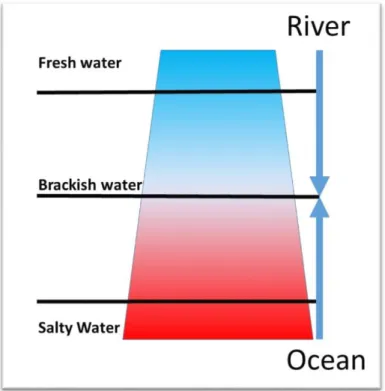
An estuary corresponds to the river portion where the effect of the sea (or ocean) in which it flows is more noticeable (Fig. 1). It concerns the entire portion of the river where the water is salty and brackish. As previously described, the river portion flowing in to the sea and influenced by the sea is called Estuary in a broader sense, and the river mouth is the last part, the part of the estuary most in contact with the sea or the ocean. Ocean and Sea are here used as synonyms.
Figure 1. - The general salt-freshwater gradient in estuaries follows this cline, between Ocean and River conditions.
In 1967 Donald W. Pritchard, considered great specialist in estuaries (ROMAÑA, 1994) proposed a definition of them based on scientific considerations: an estuary is a confined body of water with a free connection to the open sea and which seawater is measurably diluted with fresh waters drained in the watershed.
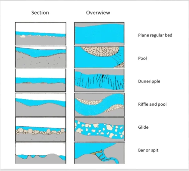
It is interesting to note that the word "tide" was not mentioned because some estuaries are not under the influence of tide cycles. Tides determine the tidal estuaries, being them the main dynamic factor of the estuarine cycles and related variations. For that, tidal estuaries are more variable in time and space systems. Estuaries body of water are in any case transversally confined in the estuarine bad and longitudinally confined in the area of where the upriver waters are influenced by the sea waters (Fig. 2).
Tidal estuaries are in general characterized by: longer surfaces, following the highest tide level, and because in the upper side the freshwater front is influenced by the seawaters following the
23
tide level. This estuarine freshwater portion is also commonly known “dynamical tide portion”, while the other downstream portion is commonly known as “salty tide portion”.
Figure 2. - Tidal estuary sectors and water dynamic. Upper estuary is fresh water dominant, but subject to tidal influence. In middle estuary, salt water and freshwater are mixing. In lower estuary, the influence of salt water is dominant. Related estuary sectors boundaries are mobile (dotted lines); the shift is subject to tidal cycle, seasonal and occasional floods.
Following ROMAÑA (1994), the tidal estuaries are classifiable reflecting the distances reached by the tide influence (between 100 and 200 km in the large French estuaries, and few tens of kilometers for the small ones). In tidal estuaries, the dispersion introduced by the periodic movement of water (estuarine swing) upstream and downstream makes sea and river waters diluted following a salinity gradient. For that, we can distinguish estuaries in:
- big estuaries (from around 100km longer); - small estuaries (under 100km);
- very small estuaries (few meters). In that case we could have a very balanced flux swing between sea and river waters (i.e.: in Lagoon and brackish marshes) or a dominant sea condition like in Bay, with a weak river influence (i.e.: torrents, rivulets, ria), or a mixed condition.
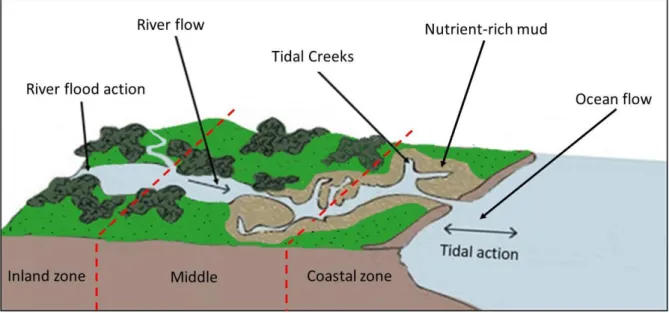
In tidal estuaries, the inner portion consists in the point where the water table level is still influenced by the tidal dynamic but remaining always in freshwater condition. In any case, estuarine dynamics are influenced up-to-downstream also by the full and lean seasonal cycles of rivers. In all types of estuaries, the bed, meanders, banks and terraces are constantly reshaped by the water flows cycles; by continued or alternative filling/erosion of materials; by suspensions coming from river or from the sea flows, creating a “permanently unstable” environment under recurrent perturbation or just occasional perturbation influencing the biological expression. In any case, estuaries represent a geography and geomorphology gradient between cost and inland. According to VALLE-LEVINSON (2010) the most widely accepted
definition of an estuary was proposed by CAMERON & PRITCHARD (ńř63) “a semi enclosed
coastal body of water, with free communication to the ocean, and which ocean water is diluted by freshwater derived from the inner land”. Always according to both previous authors, the temperate estuary type is generally considered as the classical estuarine system. Arid, tropical and subtropical basins could make exceptions because their related basins could easily exhibit
24
different hydrodynamics. In this way, the estuarine water system could be quite different also if the geography and geomorphology aspect are similar or the same.
Figure 3. - General geomorphologic variation between inner and coastal estuary portions.
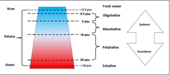
According to VALLE-LEVINSON (2010), the water salinity gradient is following the coastal-inland gradient (Fig. 3). The saltiest waters are in the estuary river mouth, brackish water in the middle, while in the inner estuarine zone, there are only freshwaters. In temperate estuaries, as it is for our study, the freshwater entering the estuarine bed establishes longitudinal and transversal density gradients that results in a long-term surface outflow and inflow (Fig. 4). Here the freshwater input is the main driver of the long-term (order of months) circulation through the difference on waters density. The estuarine system could be subdivided in salinity portions following the average water salinity concentration – following the international thalassic series of the “World Ocean Atlas 2ŃŃř” 6, from the downstream to upstream.
Salty water domain:
- Euhaline (mixoeuhaline) zone – more than 30 psu; - Polyhaline zone – between 30 and 18 psu.
Brackish water domain:
- Mesohaline zone – between 18 and 5 psu; - Oligohaline zone – between 5 and 0.5 psu. Freshwater domain:
- under 0.5 psu.