HAL Id: insu-01886024
https://hal-insu.archives-ouvertes.fr/insu-01886024
Submitted on 9 Oct 2018HAL is a multi-disciplinary open access archive for the deposit and dissemination of sci-entific research documents, whether they are pub-lished or not. The documents may come from teaching and research institutions in France or abroad, or from public or private research centers.
L’archive ouverte pluridisciplinaire HAL, est destinée au dépôt et à la diffusion de documents scientifiques de niveau recherche, publiés ou non, émanant des établissements d’enseignement et de recherche français ou étrangers, des laboratoires publics ou privés.
grabens, Central Tunisian Atlas and their geodynamic
implications
Amira Rjiba, Tahar Aifa, Mohamed Ghanmi, Ahref Boulares
To cite this version:
Amira Rjiba, Tahar Aifa, Mohamed Ghanmi, Ahref Boulares. Geophysical data from Kalaa Khesba and Kalaat Senam grabens, Central Tunisian Atlas and their geodynamic implications. Earth Ressources and Environmental Remote Sensing / GIS Applications, Sep 2018, Berlin, Germany. pp.10790-40. �insu-01886024�
1
Geophysical data from Kalaa Khesba and Kalaat Senam grabens, central
Tunisian Atlas and their geodynamic implications
Amira RJIBA
1,2,*, Tahar AÏFA
1, Mohamed GHANMI
2, Achref BOULARES
31 Univ Rennes, CNRS, Géosciences Rennes - UMR 6118, Bat. 15, Campus de Beaulieu, F-35000 Rennes, France 2 Université de Tunis El Manar, Faculté des Sciences de Tunis, UR11ES13 Géomatique Géologie Structurale et
Appliquée, 1060 Tunis, Tunisia
3 Entreprise Tunisienne d’Activités Pétrolières (ETAP), 54, Avenue Mohamed V, 1002 Tunis, Tunisia
* Amira.rjiba@univ-rennes1.fr
Abstract
The geophysical techniques are more and more effective compared to the classical methods through the scientific and technological progress. The Geophysical prospecting based on seismic and gravimetric methods has shown the lateral evolution of facies and evidenced the structure of the NW grabens. In addition, the data set was found to have a good understanding of the structural geology of the region. Our study area is part of the northwestern Tunisia, whose geological evolution is strongly marked by the behavior of the whole Alpine chain of north Africa and the western Mediterranean. The lithostratigraphic correlations established using outcrops, well log and seismic data, allowed to better understand the structural complexity and the role of the various tectonic accidents that contributed to the current configuration, highlighted by the presence of grabens. The NW-SE, NNW-SSE to NS and NE-SW to EW faults played a major role in the genesis of the folds and the opening of the NW-SE grabens. A NW-SE compression which resulted by prevailing unconformities widely identifiable on the lithostratigraphic column is evidenced within the L1 seismic line. These unconformities, representing reverse faults, were interpreted as an overlap on this L1 seismic line. Gravity data with a negative anomaly also corroborate the seismic interpretation, confirming the structure of Kalaa Khesba graben, composed of Mio-Plio-Quaternary series.
Keywords: Kalaa Khesba, Kalaat Senam, seismic, gravity, thrust.
1. Introduction
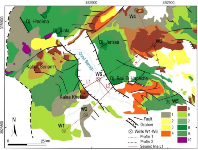
The region of Kalaat Senam is located in the northwestern Tunisia, in which the geological evolution is strongly marked by the whole behavior of the north African Alpine Chain (Maghrebides) and the western Mediterranean (Fig. 1). Indeed, the central part of the country is marked by the existence of several NW-SE and WNW-ESE grabens (Burollet, 1991). Atlasic troughs are associated with strike-slips and evolve most often in pull-apart (Chihi, 1995).
The study of Kalaat Senan area was performed within the framework of structural and geophysical analyses regarding the emplacement of troughs and associated structures. In fact, the major ultimate objective is to inspect the different interpretations and hypotheses considering the existence of geological conditions leading to the presence of hydrocarbons using geophysical techniques (2D seismic and gravimetric data). As a matter of fact, these methods allowed to (i) specify the deep structure of troughs, (ii) identify the major subsurface structures, and (iii) check the geometry borders of grabens.
2
Fig. 1: Simplified geological map of the study area extracted from the map of Tunisia at 1/50,000, projected on a WGS84 UTM Z32 N system. 1. Quaternary, 2. Mio-Pliocene, 3. Upper Miocene, 4. Oligocene, 5. Ypresian-Lutetian, 6. Coniacian-Maastrichtian, 7. Turonian, 8. Cenomanian, 9. Early Cretaceous, 10. Triassic.
2. lithostratigraphy
The lithostratigraphic formations of the Kalaat Senam area extend and outcrop from the Triassic to the Quaternary. In a manner that some formations, such as those of the Jurassic and the Paleocene series, outcrop only outside the region. While those of the Lower Cretaceous have a weak occurrence. Moreover several specific geological formations show variations in facies and possibly in thicknesses. The Triassic formations are presented in the shape of a chaotic lithological mixture, often largely taken up by the folding in a manner that it is impossible to develop a clear stratigraphic sequence.
The Cretaceous series outcrop widely in the northern Tunisia and along the Tunisian Atlas. Indeed, in the Kalaat Senam region, the Cretaceous formations will be described through their facies: Aptian-Albian (Hamaima, Serdj with limestones which appearing at the top ofdiapirs of Bou El Hanèche, Dj. Jerissa and Dj. Slata (Lehotsky and Bujnowsky, 1995) andM'Cherga Formations), Albo-Cenomanian (Fahdene Formation), Cenomanian-Turonian (Bahloul Formation), Turonian-Campanian (Aleg Formation), Campanian-Maastrichtian (Abiod Formation).
In the Upper Maastrichtian-Paleocene, the El Haria Formation corresponds to a series of dark gray clays or blackish ones. Consequently, they turn out to be easily identifiable in the field due to the color and morphology which are distinguished from the massive carbonate of Abiod and Metlaoui. In the Lower Eocene, a set of mainly carbonated series encompassing in its basal part a phosphate term of terminal Paleocene-Ypresian age constitutes the Chouabine Formation. In its middle part, the Eocene is represented by dominant carbonate alternations. Its upper part is represented by a carbonated term with nummulites of Ypresian-Lutetian age corresponding to the El Gueria Formation.
3
At the Late Paleocene-Lower Ypresian, the Chouabine Formation lies on top of the El Haria Formation. In fact, it is represented by an alternation sequence of phosphorite marls, marls and carbonates. The Miocene Formation is characterized by an alternation of sandstones, conglomerates and marls, and variegated marls rich of gypsum alternating with silts and sandstones. The continental Mio-Pliocene Formations are composed of conglomerates with sub-angular elements that are cemented by sandstones, alternating with a set of sandstones and clays.
3. Geophysical data
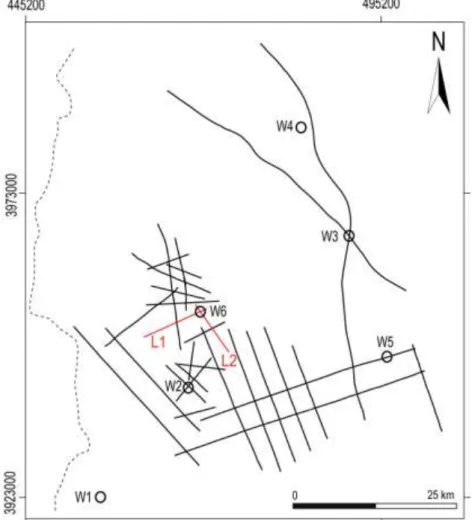
The geophysical data represents the 2D seismic data which result from the database of ETAP. The seismic survey profiles were realized by ETAP in the graben of Kalaat Senam in 1970 (P1), 1981 (P2), 2011 (P3), 1945 (P4), 1967 (P5), and 1969 (P6). The oil wells, considered in this study, are among six from W1 to W6 (Fig. 2). The seismic lines were established further to several seismic surveys, with different parameters of acquisition and processing stages. Their processing allowed us to improve the seismic sections for a better interpretation.
The acquisition of gravimetric data was made using a CG3 gravity-meter within the framework of the Tunisian gravimetric Atlas. A general gravity overview was first conducted using a Worden gravity-meter in the Kalaat Senam-Kalaa Khesba area. A correlation between the density of Nettleton and the measured densities gave a regional density of 2.4 g.cm-3.
Fig. 2: Map showing locations of seismic lines in the NW study area of Tunisia. W1-W6: oil wells. 4. Results and interpretation
The interpretation of the seismic lines, i.e. isochron, isovelocity and isobath maps allows to obtain a succession of tectonic events which succeeded one another between the Triassic and the Present day. Compressive phases of NW-SE direction appear to be responsible for block tilting and the creation of
4
anticlinal and synclinal structures affected by many normal, reverse faults or strike-slips. The extension of the NE-SW direction guided the formation of structures in grabens, half-grabens and vast synclines. The seismic profiles show that the NW of Tunisia is characterized by lateral and deep variations of facies, unconformities, sedimentary gaps, and folded and faulted structures. This results in complex structures deduced from the superimposition of the compression phase during the Miocene.
5
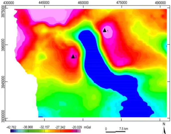
Fig. 4: Residual anomaly map of order 3 of Kalaa Khesba and Kalaat Senam
The interpretation of the gravimetric data (Bouguer, regional and residual anomaly maps, etc.) were made to better follow the behavior of the various accidents in the region and to follow their depths and dips (Spector and Grant, 1970; Thompson, 1982; Reid et al., 1990, 2003; FitzGerald et al., 2004; Chen et al., 2014). These maps, based on several applied treatments (derivatives, Euler deconvolution, upward continuations, etc.), led to the definition of the lineaments related to the Atlasic tectonic regime (Figs. 3,4). The variation of anomalies on the maps indicates the depths of each structure. Within the Kalaa Khesba graben a negative anomaly at shallow depth, as well as a generally NW-SE fault direction bordering this graben, were identified. This anomaly reflects the existence of low density series compared to the basement density. At subsurface, well data located in the centre of the trough ensured the presence of Triassic material. Indeed, the gravimetric response in terms of anomaly presents the association of Triassic evaporites resulting in series of low density.
5. Conclusion
The study area belongs to an extended NW-SE domain that occupies a privileged place in the NW Paleogeography of Tunisia. Geological data analysis as well as the tectonic events of the Tunisian grabens of the central Atlas region that have been proposed (Ben Ayed, 1986; Chihi, 1995; Dlala, 2001), showed that the tackled series were presented from the Triassic to theQuaternary and helped us to explain the grabens border structure (Caire, 1971; Burollet and Rouvier, 1971; Ben Ayed, 1986; Chihi, 1995; Gabtni et al., 2016). The results were supported by seismic and gravimetric data interpretation. From seismic reflection, they show that (i) the horizons sequence within the grabens, (ii) the main faults orientations that have contributed to its current configuration, (iii) the activation of the bordering faults of the grabens as well as the large fault supporting fault branches leading to a
6
flower structure. From gravimetry, they show (i) the faults activation and their movements, as well as (ii) the mobilization and raise of the Triassic material. Within the trough, a negative anomaly that reflects the existence of low density series, and an NW-SE fault direction bordering this graben were evidenced.
6. References
Ben Ayed, N., 1986. Evolution tectonique de l’avant pays de la chaine alpine de la Tunisie du début du Mésozoïque à l’actuel. Thèse d’Etat, Univ. Paris XI, 327p.
Burollet, P.F., Rouvier, H., 1971. La Tunisie. Unesco, Tectonique de l’Afrique (Sciences de la Terre), 6, 600p.
Burollet, P.F., 1991. Structures and tectonics of Tunisia. Tectonophysics, 195, 359-369.
Caire, A., 1971. Chaînes alpines de la Méditerranée centrale (Algérie et Tunisie septentrionales, Sicile, Calabre et Apennin méridional). Unesco, Tectonique de l’Afrique (Sciences de la Terre), 6, 584p. Chen, Q., Dong, Y., Cheng, S., Han, L., Xu, H.H., Chen, H., 2014. Interpretation of fault system in the
Tana Sag, Kenya, using edge recognition techniques and Euler deconvolution. Journal of Applied Geophysics, 109, 150-161.
Chihi, L., 1995. Les fossés néogènes à quaternaires de la Tunisie et de la mer pélagienne : Leur étude structurale et leur signification dans le cadre de la Méditerranée centrale. Thèse de Doctorat, Faculté des Sciences de Tunis, 400p.
Dlala, M., 2001. Les manifestations tectono-sédimentaires d'âge Campanien–Maastrichtien en Tunisie: implications sur l'évolution géodynamique de la marge Nord-Africaine. C.R. Geoscience, 334, 135-140.
FitzGerald, D., Reid, A., McInerney, P., 2004. New discrimination techniques for Euler deconvolution. Computers & Geosciences, 30(5), 461-469.
Gabtni, H., Hajji, O., Jallouli, C., 2016. Integrated application of gravity and seismic methods for determining the dip angle of a fault plane: Case of Mahjouba fault (Central Tunisian Atlas Province, North Africa). J. Afr. Earth Sci., 119, 160-170.
Lehotsky, I., Bujnowsky, A., 1995. Notice explicative : carte géologique de Kalat Es Senan. Feuille n°59.
Reid, A.B., Allsop, J.M., Granser, H., Millet, A.J., Somerton, I.W., 1990. Magnetic interpretation in three dimensions using Euler deconvolution. Geophysics, 55(1), 80-91.
Reid, A.B., 2003. Euler magnetic structural index of a thin-bed fault. Geophysics, 68(4), 1255-1256. Spector, A., Grant, F.S., 1970. Statistical models for interpreting aeromagnetic data. Geophysics, 35,
293-302.
Thompson, D. T., 1982. EULDPH: A new technique for making computer-assisted depth estimates from magnetic data. Geophysics, 47, 31-37.