Publisher’s version / Version de l'éditeur:
Vous avez des questions? Nous pouvons vous aider. Pour communiquer directement avec un auteur, consultez la
première page de la revue dans laquelle son article a été publié afin de trouver ses coordonnées. Si vous n’arrivez pas à les repérer, communiquez avec nous à PublicationsArchive-ArchivesPublications@nrc-cnrc.gc.ca.
Questions? Contact the NRC Publications Archive team at
PublicationsArchive-ArchivesPublications@nrc-cnrc.gc.ca. If you wish to email the authors directly, please see the first page of the publication for their contact information.
https://publications-cnrc.canada.ca/fra/droits
L’accès à ce site Web et l’utilisation de son contenu sont assujettis aux conditions présentées dans le site LISEZ CES CONDITIONS ATTENTIVEMENT AVANT D’UTILISER CE SITE WEB.
Internal Report (National Research Council of Canada. Division of Building Research), 1957-06-01
READ THESE TERMS AND CONDITIONS CAREFULLY BEFORE USING THIS WEBSITE.
https://nrc-publications.canada.ca/eng/copyright
NRC Publications Archive Record / Notice des Archives des publications du CNRC :
https://nrc-publications.canada.ca/eng/view/object/?id=2a4a7f17-dc38-4b9c-9dda-49858c62611b https://publications-cnrc.canada.ca/fra/voir/objet/?id=2a4a7f17-dc38-4b9c-9dda-49858c62611b
NRC Publications Archive
Archives des publications du CNRC
For the publisher’s version, please access the DOI link below./ Pour consulter la version de l’éditeur, utilisez le lien DOI ci-dessous.
https://doi.org/10.4224/20337989
Access and use of this website and the material on it are subject to the Terms and Conditions set forth at
Reconnaissance of craters south of Norman Wells, N.W.T.
NATIONAL RESEARCH COUNCIL OF CANADA DIVISION OF BUILDING RESEARCH
RECONNAISSANCE OF CRATERS SOUTH OF NORMAN WELLS» NoWoT e
by
GoHo Johnston
ANALYZED
Report No" 120
of the Division of BU1.1ding Research
Ottawa
PREFACE
This little paper records the result of a reconnaissance of some large craters near Norman Wells which was made at the request of members of the National Research Council who saw
these phenomena when flying up to Norman Wells in June QYUVセ
Even though further information is being ッ「エ。ゥョ・、セ
this note is issued in this incomplete form in view of the expressed interest of members of the Council in the craterso
The Division of Building Research here records its appreciation to the Department of Mines and Technical SurveysD and to the several members of the staff of this Department who assisted us kindly in making the reconnaissance possible through the use of the departmental helicopter when it was passing through
Norman w・ャャウセ
Ottaw8g
Juneg QYUWセ
Robert fセ Leggetg
RECONNAISSANCE OF CRATERS SOUTH OF NORMAN WELLSg NoWoTo by
G.H. Johnston
In June 1956 the regular summer meeting of the National
Researcb Council of Canada was held in Saskatoon instead of Ottawao
After the meeting, Council members began a ten-day aerial tour of
northwest Canada that included a カゥセゥエ to Norman Wells from where
short trips were made, including visits to the old and new sites
of Aklaviko
During the flight to Norman w・ャャウセ the pilot of the
aircraft directed the attention of Council members to a crater
located a few miles southeast of Norman Wellso Such interest was
shown that the staff of the Northern Research Station of the
Division of Building Research, stetioned at Norman Wellsg were
asked to investigate this unusual feature o
Since the crater was in a relatively inaccessible regiong
the Department of Mines and Technical Surveys was approacped for
permission to use one or two helicopterso These were supporting
the Department's topographical survey party in the field northwest
of Aklaviko The helicopters passed through Norman Wells on August
30, 1956D GoR. Johnston, accompanied by JoC o pャオョセ・エエR made a
reconnaissance trip to the cratero Approximately two hours were
spent on the ground and one hour was taken in flying to and from
the crater and in making a couple of oircuits of エィセ 。イ・セッ
While circling the areag two more craters (not as well
defined) were noted in the vicinity of the one first reported o
It was not possible, howeverg to land near these craters
(designated as Nos 2 and 3)9 so Noo 1 only was investigated
from the ground o Photographs of these craters were taken from
the air and are included along with photographs of crater Noo 1 taken from the ground o
A plan of the Vermillion Creek area (found in the IDOoLo office at Norman Wells) drawn by the UoS o Army Engineers during Canol time describes these craters as "limestone sinks"o
Location
The craters are located approximately 25 miles southeast
of Norman Wells and about 5 miles north of the Mackenzie Riverg
close to Vermillion Creek HVUᄚPXセn and 126°069. ) 0 Crater Noo 1
2
-approximately 1500 fto east of the creeko Vermillion Creek drains
to the Mackenzie River from the Norman range of the Franklin Mountains, cutting through the uplands that rise steadily from
the rivero The mountains are 7 to 8 miles from the river o The
craters are in an area the elevation of which is approximately 875
fto above sea-level (i.e0 9 about 700 fto above the イゥカ・イIセ
Crater No o 1 (Figso 1 to
4)
The crater is elliptical in shape, the length along the
major axis being about 350 ft.p and along the minor axis about
175 ft o p the major axis being oriented in a general northeast to
southwest direction o The sheer キ。ャセ of the crater are a
distinctive feature o Vegetation overhangs the top making it
difficult and dangerous to approach the edge o The depth to the
very bright turquoise-coloured water セョ the bottom is 105 ft. It
was not possible to sound the depth of the watero
From 10 to 12 ft. of a stony, silty overburden overlies
bedrock. The rock formation consists of stratified brown to grey
shales extending down to the water surface in the crater and
dipping slightly to the southwest. It was not possible to obtain
rock samples from the crater. Time did not permit an examination
of the exposures on the bank of the creek several hundred feet awayo
The ground surface slopes from northeast to southwesto
The northeast end and the north side of the crater are at
approximately the same elevation while the south and southwest sides are about 5 ft. and 8 ft. respectivelY9 lower than the
northeast end (as determined with a hand level) 0 Water samples
were not obtained because the sounding line was not long enougho
It was noted that water seepage seemed to occur about 20 fto from the ground surface at the north-northeast corner and about 60 ftc from the ground surface at the south=southwest
cornero A hole was bored using a 1 QORセゥョN
¢
hand augerp about30 fto away from the southwest end. A 4=in o layer of dry moss
covered a dry brownish silt-clay containing streaks of black
organic materialo Water was struck at 6 fto, a stone (or bedrock)
ended the hole at
6
fto 2 ino No frozen ground was encountered inthe hole.
The area in the vicinity of the crater had been burned
over within エセ・ past 2 or 3 yearso The vegetation ゥセ・、ゥ。エ・ャケ
surrounding the crater consists of scattered birch trees up to 6 in. in diameter and from 15 to 20 ft. high and small spruce
3
-up to 3 ina in diameter, 10 to 15 ft. higho The ground surface
is covered by dry moss and small plantso Fairly extensive wet
muskeg areas, with カ・ァ・エセエゥッョ covers varying from scattered small
knee-high shrubs to fairly dense small spruce up to 3 ino in
diameter, cover the area to the south and southwest of tne cratero
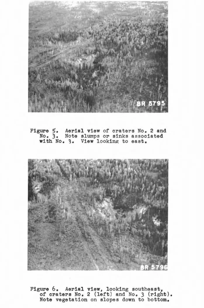
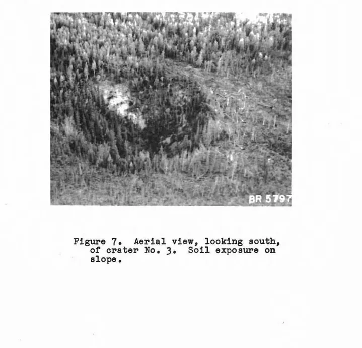
Craters Nosa 2 and 3 (Figso
5
to 7)These craters were examined quickly from the airo They
lie about
75
ft. apart, and appear to be not more than40
fto deepand 100 ft. in diameter. Vegetation in the form of spruce trees
and shrubs grows down the sloping walls to the bottom of each
craterp where pools of water were visibleo Two or three slumps
or sinks branch out to the west from crater Noo
3
(west of Noo 2)0No rock exposures were notieed on the sloping walls of these craterso
Geology
Following the termination of the Canol project, a number of exploratory wells were drilled by Imperial Oil Limited outside the Norman Wells field, in the hope of finding further oil bearing
formations 0 None, however, proved successfulo One such wellg
drilled in
1945
to a depth of5972
ft., was located on the northside of Vermillion Creek about 1 1/2 miles northeast of crater
Noo
10
The log of Vermillion Ridge Noo1
well (elevation -1055
fto)is given at the end of this reporto
This log shows that layers of anhydrite and gypsum occur
in the limestones and shales at some deptho Below these formations
lie very thick salt beds o Sulphur springs have been observed
issuing from the face of Vermillion Creek gorge9 that part of the
creek immediately adjacent to the craters (1).
It may be assumed, therefore, that. percolating ground water has dissolved and decomposed those minerals susceptible to solution,
thus weakening the structure so that cave-ins occuro The craters
are the resultant ground feature. Other Crater Occurrences
The occurrence of several craters has been noted on aerial photographs several miles to the west of Norman Wells and the
Mackenzie River, near the Carcajou Rivero Others have been
4
-It is hoped that a field trip by canoe and on foot can be
made during the summer of
1957
when a complete survey of the areacan be carried out. Constable Innis of the RoC.MoP. stationed
at Ft. Norman is to make a patrol up Vermillion Creek this winter and kindly promised to take some rock samples from the banks of the creek.
References
I. Hume, G.S. The lower Mackenzie River area, Northwest
Territories and Yukon, Geological Survey of Canada,
Memoir
273, 1954, 118
po- 5 ...
Vermillion Ridge Noo 1 Well Log
Age Formation Lithology Depth in ftl!
Upper Devonian Lower Fort Dark 「セッキョゥウィ grey shales
Creek
Middle DavarlBn Ramparts Mainly limestone, with less
shale
Silurian or Bear Rock Dolomitic limestone with
Devonian pyritic nodules;
carbo-naceous partings;
anhydrite in lower part
Silurian Ronning polomitic limestoneg hard
and dense; interbedded with anhydrite and green shale
0-470
470-8.53
1,297-2 g799
Cambrian MacDougal Green and red ウィ。ャ・セ with
dolomite and gypsum; shale and gypsum at th9 base Salt series - mainly rock
salt, SァSVYセTYTPR[ limey
siltstone with salt and
gypsum,
49402=49470,
mainlysalt, with less amounts of
limey and silty bedsg
セYTWPMTYVUV[ mainly silt-stone with less amounts of
salt and gypsumo
49656-セァRRU[ mainly rock saIto
Gg225-5927S;
silt-stonegshale, and saJt 9
59275<=>
セYUSP[ chiefly rock saIto
UァUSPセNUYNUXR
Greenish grey shale
Shale, greenish9 g r e y , and
purple, finely laminated and calcareous, fossils abundant, chiefly small trilobites
2,799-3,369
3£1369-.59582
5,582-.59788
BR
5791
Figure 1. Aerial view of
crater No. 1 looking northeast along major
axis. Note muskeg area
to right of crater where · helicopters landed.
Also sheer walls.
Figure 2. Aerial
view showing rook stratification and depth of over-burden on south
side of crater No. 1.
Figure
3.
Ground view of south wall of crater No.1.Figure
4.
Groundview looking along major axis to northeast end of crater No.1. Note men standing at edge for scale.
Figure
5.
Aerial view of craters No. 2 and No.3. Note slumps or sinks associated with No.3. View looking to east.Fi gure
6.
Aerial view, looking southeast, of craters No.2 (left) and No.3 (right ) . Not e vegetation on slopes down to bottom.Figure