HAL Id: hal-02155043
https://hal.archives-ouvertes.fr/hal-02155043
Submitted on 13 Jun 2019
HAL is a multi-disciplinary open access archive for the deposit and dissemination of sci-entific research documents, whether they are pub-lished or not. The documents may come from teaching and research institutions in France or abroad, or from public or private research centers.
L’archive ouverte pluridisciplinaire HAL, est destinée au dépôt et à la diffusion de documents scientifiques de niveau recherche, publiés ou non, émanant des établissements d’enseignement et de recherche français ou étrangers, des laboratoires publics ou privés.
Marion Dumont, Guillaume Touya, Cécile Duchêne
To cite this version:
Marion Dumont, Guillaume Touya, Cécile Duchêne. Automated Generalisation of Intermediate Levels in a Multi-Scale Pyramid. 18th ICA Workshop on Map Generalisation and Multiple Representation, Aug 2015, Rio de Janeiro, Brazil. �hal-02155043�
1
Automated Generalisation of
Intermediate Levels in a Multi-Scale Pyramid
Marion Dumont
1, Guillaume Touya
1, Cécile Duchêne
11. Motivations
For planning some trip or localising an area of interest, people can use mapping applications such as GoogleMaps, OpenStreetMap or the governmental Geoportals. These tasks involve navigating through data by panning, zooming in a scale range or switching between different types of geographic information (topographical map, satellite imagery, thematic data, etc.). It uses a large set of data, from various sources and with different representations or resolutions.
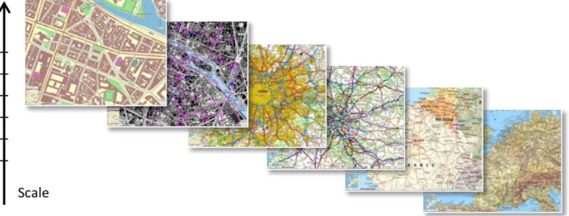
A mapping application displays a multi-scale map (or pyramid), where each scale (or level) represents a specific level of detail. These levels can present large differences in terms of content and representation (Figure 1), owed to the data heterogeneity, the generalisation processes or the symbolization choices. These gaps may disturb or even lose the user while zooming in and out, making sometimes the map navigation cognitively difficult.
Figure 1. Pyramid levels can present large differences (source: IGN-France)
In this context, adding intermediate levels to the multi-scale pyramid could be one way to reduce these gaps and to improve the smooth zooming. This paper introduces a starting research project that seeks to validate this hypothesis and to develop methods for the automated derivation of such intermediate levels.
This problem is connected with various issues, some of which are presented in this paper. Based on examples stemming from existing web maps pyramids, section 2 presents two kinds of gaps that can disturb the navigation in a multi-scale map. Then, section 3 highlights some related work existing in the literature. Finally, section 4 concludes the presentation with perspectives and future researches.
2. Problems in Multi-Scale Navigation
The use of mapping applications, such as GoogleMaps, OpenStreetMap, but also some National Mapping Agencies geoportals (IGN-France, Swisstopo-Switzerland, ICGC-Catalonia, BEV-Austria) allows us to notice potential sources of user disorientation. We distinguish two different kinds of issues: discontinuities and inconsistencies. Discontinuities are defined between two levels, where representation or content changes from one scale to another. Inconsistencies can be found between three levels, for instance where representations are similar in the first and the last level but different in the middle level.
1 COGIT - IGN France, 73 avenue de Paris 94165 Saint-Mandé France (mail : [email protected])
2
a. Symbolization discontinuities
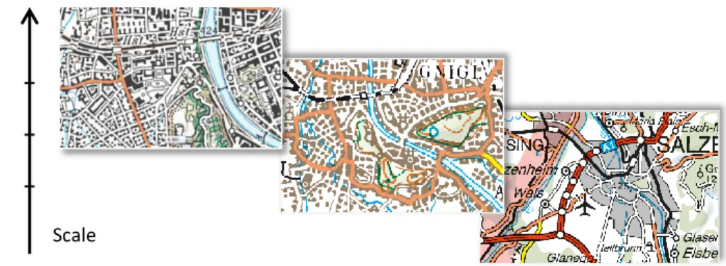
Our first observation is related to the symbolization disparities (Figure 2). In this example from ICGC data, a salient object is symbolised by beige colour in one level, whereas in the next level a close colour is used to represent urban areas. Thus, the colour but also the shape of this object are changing from one scale to another. Major roads, useful landmarks for navigation, also change colour. This loss of landmarks may disorient the user. In this case, a style interpolation between both levels as used in [Hoarau et al, 2015], may be useful to derive an intermediate level.
Figure 2. Topographic maps at 1:50k and 1:25k (source: ICGC-Catalonia)
Even larger differences can appear if the pyramid is constituted of maps with independent styles (Figure 3, left). Is a multiple style interpolation enough to compensate for the disorientation feeling or is the use of a single style required (Figure 3, right)?
Figure 3. Multi-scale pyramid with different (left) or common (right) style (source: IGN-France)
b. Content discontinuities
The second potential source of disorientation that we highlight is the breaks of content (Figure 4). The example of settlement areas is maybe the easiest to spot, as their representations are very different: buildings, urban blocks, urban areas and city point symbols. How can we derive an intermediate representation to improve the smooth zooming?
Figure 4. Different representations of settlement areas in a multi-scale pyramid: buildings, urban blocks and urban areas with city point symbols (source: BEV-Austria)
Scale
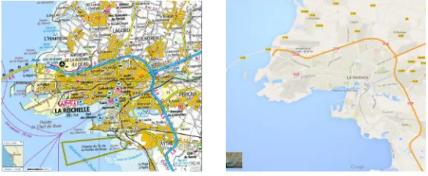
3 Data providers do not agree on the level of detail to use at a given scale (Figure 5). This can imply very different map contents at a same display scale (Figure 6). At which scale range may a level of detail be associated?
Figure 5. Buildings abstraction at the same scale in GoogleMaps, OpenStreetMap and SwissTopo data
Figure 6. Difference of content quantity between maps from IGN-France and GoogleMaps
Simplifications between levels of detail may be drastic, owed to the scale gap, which can disturb the navigation. How can we manage a smooth evolution of content? We think that the answer may be in finding the relation between the map scale, the level of detail and the generalisation strength. However, it assumes that this strength can be characterised on an absolute scale and that we are able to parameterise a generalisation processes to respect it. The minimum gap of content, acceptable to ensure a smooth zooming, also has to be found for defining how many levels are needed.
c. Content inconsistencies
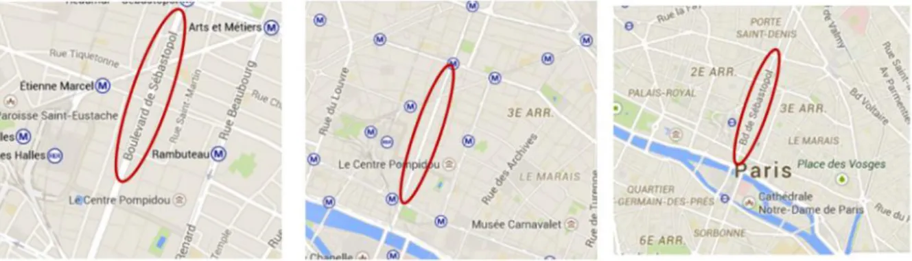
Between levels, objects sometimes move (Figure 7) or disappear and then reappear (Figure 8), implying content inconsistency. This may also cause user distraction, as it catches the eye. Obviously, these inconsistencies are easier to detect when levels share the same style and the same content abstraction.
4
Figure 8. Content inconsistency between three successive levels in GoogleMaps data
The examples that we found concern map names, certainly owed to their placement optimisation. This process may improve single map legibility but can be disturbing in a multi-scale map. Even if no example of other themes inconsistency has been found during our preliminary study, this requirement has to be considered for generalising intermediate levels. How can we ensure their consistency? Our hypothesis is that the generalisation processes should take into account the existing levels. Should this knowledge be considered before, during or after the generalisation [Girres and Touya, 2014]?
In any case, we will need links between the multiple representations, to be able to access them when generalising an intermediate level. These links can be available if the pyramid levels have been obtained from the same source (Figure 9, left) and if the links have been stored during the generalisation. In other cases (Figure 9, right), we will need some matching operations to create these links.
Figure 9. Different strategies of pyramid building (source: IGN-France)
Adding thematic data raises more questions. Is it relevant to represent the thematic data on the closest intermediate level or do we need to create a new one at the thematic data scale? In both cases, thematic data often need to be adjusted on topographic data. Matching operations may again be needed. Different data sources Same data source Links of generalisation Scale
5
3. Related Work
The research questions highlighted in previous section relate to several parts of the generalisation literature. This section describes some work that we believe to be closely related to our problems.
a. Multi-Representation Databases
Using an MRDB during a generalisation process presents some huge benefits [Mustière and van Smaalen, 2007]. Such database stores linked multi-representation of geographical objects [Kilpeläinen, 2001; Vangenot et al, 2002], allowing the detection of inconsistencies, the propagation of updates but also the awareness of existing smaller scales in a generalisation process. Indeed, when the generalisation process considers an object, these links quickly give its less detailed representations. Thus, generalisation processes become aware of multi-representation (MRDB aware) and can use these less detailed representations to guide generalisation. MRDBs can also be extended to include horizontal relations (i.e. spatial relations between objects at the same representation level) and temporal relations (i.e. updates) [Bobzien et al, 2008]. Such enhancements are quite useful for our problem where spatial relations transformations over scales are essential to enable smooth transitions.
Different strategies exist to build an MRDB [Devogele et al, 1998]. When the representations already exist in several independent datasets, data matching techniques can be used to link homologous objects. A recent example of data matching method, mixing geometric, topological, semantical and labelling criteria, is proposed by [Olteanu-Raimond et al, 2015].
b. Continuous and Multi-Scale Generalisation
Continuous generalisation is also related to the derivation of intermediate maps, as it allows the continuous transformation of map objects over scale. Different types of continuous generalisation have been studied including the morphing of lines, for instance in [Nöllenburg et al, 2008], the continuous selection of a road network in [Chimani et al, 2014], or the continuous deformation of polygons in [Danciger et al, 2009].
Vario-scale is another type of continuous generalisation [van Oosterom et al, 2014]. The tGAP and Space-Scale Cube structures [van Oosterom et al, 2014] avoid redundancy, by storing only the minimum information for the different representations of the map objects in a continuous scale range. The representations are linked by edges, forming vertical objects, as 3D volumes for polygons. This kind of morphing between multiple representations allows a smooth zooming, as a continuous generalisation.
Some other systems, such as the ScaleMaster from [Brewer and Buttenfield, 2007], extended by [Touya and Girres, 2013], are more multi-scale than continuous as they provide maps at any scale but no continuous representation of map objects. The ScaleMaster defines scale ranges for each theme of the map that are obtained by the application of a list of generalisation processes on a given data source (Figure 10).
6
c. Consistent and Smooth Zooming
When several scale levels already exist in the pyramid, there is a risk that intermediate levels might be inconsistent with the less detailed levels (Figure 11). Then, so-called MRDB aware generalisation [Girres and Touya, 2014] is required. The constrained tGAP [Dilo et al, 2009] is an improvement of the tGAP structure where continuous aggregations are guided by the objects existing in other less detailed levels. For cases where data are not necessary cadastral-like (forming a tessellation of space), other MRDB aware strategies are presented and tested in [Girres and Touya, 2014].
Figure 11. Inconsistencies in an intermediate railroad network and a solution with an MRDB aware generalisation [Girres and Touya, 2014]
Consistent intermediate levels may also be obtained by a ladder sequence of generalisation processes. Indeed, with a selection operation for instance, generalising each scale level from the previous result of the sequence ensures the pyramid consistency: a removed object cannot be selected at the next step and thus cannot reappear. This approach is used in [Raposo et al, 2013], which focuses on labelled points selection, by using a space tessellation by rectangles. In each rectangle, the most important feature is tagged and selected for the next scale level. Another approach for point features selection is proposed in [Schwartges et al, 2013]. This continuous method represents point features as cones in a scale space. Cones intersections mean that objects are overlapping (Figure 12). Some cones are then truncated to resolve these spatial conflicts. This method ensures the content consistency, but also optimises the selection process by maximising the cones height.
Figure 12.The principle of visibility cones from [Schwartges et al, 2013]: the label q has been truncated here.
Research on smooth zooming operations is also related to the derivation of intermediate levels. Different strategies have been studied in the literature: pure MRDB-based methods with many representations stored in the database [Zhou, 2014], stage transitions [van Kreveld, 2001], or a mix of MRDB and on-the-fly continuous transformations [Cecconi and Galanda, 2002].
7
d. Level of Detail and Degree of Generalisation
Setting the graduations of zoom levels in a geoportal and choosing the map displayed at each zoom level forces us to consider the literature related to level of detail (LoD) and what Zhou calls the degree of generalisation, which relates LoD and screen resolution [Zhou and Jones, 2003; Zhou, 2014]. The same notion of degree of generalisation, which summaries how much information is generalised, has been addressed by papers on web service based on-demand generalisation [Gould, 2012]. For instance, [Foerster et al, 2007] uses a simplification ratio, derived from the radical law [Töpfer and Pillewizer, 1966] to parameterise line simplification algorithms embedded in web services.
4. Perspectives and future work
Based on our first observations, we are making a deeper analysis on a panel of sixteen general and national applications (e.g. Google Maps or the French geoportal). The study of the multi-scale pyramids content will allow us to compare the different used strategies for the scales distribution. For instance, finding a common scale in most applications may let us think that it is a useful scale and thus a required one. Then, we will survey the different representation changes (Figure 4) used in these applications, which mark the main gaps between the pyramid levels.
Understanding the disturbing feelings in these gaps will allow us to define the problems to solve. It will give us constraints [Beard 1991; Balley et al, 2014] that the intermediate levels should respect. Besides, comparing the applications content at a same scale may give us ideas on the relation between scale and degree of generalisation. It may guide the derivation of intermediate levels. We are thinking about user tests to find the maximal difference beyond which the feeling is disturbing, but also the minimal distinguishable difference that two levels should respect (i.e. it is useless to maintain two very similar levels).
We will thus need a difference measurement. Two levels can be different in terms of content, symbolization or both. The generalisation process may decrease the number of objects (selection, aggregation or typification), but also modify their shape and symbolization or move them to ensure their legibility. Measuring the number of deleted, aggregated or modified objects may give us an idea of the distance between two levels. More globally, visual density and clutter measurement [Touya et al, 2015] can help to control the homogeneity of the multi-scale pyramid.
Then, with these constraints and validation methods, we will try to model a generalisation process. A global system, such as the ScaleMaster (Figure 10), may help us to orchestrate this complex process. We will focus on how to parameterise the generalisation operators to reach a given target scale. Beginning with smaller scales seems interesting, as scale gaps between already existing maps are often bigger and therefore the content difference is more visible. This process should also take into account the existing levels to ensure the consistency. We will especially care about the spatial relationships consistency, such as topological relationships or spatial patterns for instance. However, it supposes that links between multiple representations are available, in an MRDB for instance. As initial multi-representation dataset, we can use a cartographic pyramid provided by IGN France. It contains datasets at different large scales, generalised from the same database and storing links to it. To complete our scale range, datasets are also available at smaller scales, obtained from different sources by different generalisation processes. So, we will have to use matching algorithms to link all levels. Thematic data from a risk management project are also available. Thus, our experimentation involves the different cases of pyramid building that we previously identified (Figure 9).
Acknowledgments
This work is supported by the French National Research Agency, as part of the MapMuxing project [ANR-14-CE24-0011-01].
8
References
Balley S, Baella B, Christophe S, Pla M, Regnauld N, Stoter J (2014) Map Specifications and User Requirements, in
Abstracting Geographic Information in a Data Rich World, (Eds) Burghardt D, Duchêne C, Mackaness W, Lecture Notes in
Geoinformation and Cartography, Springer, doi:10.1007/978-3-319-00203-3
Beard K (1991) Constraints on rule formation, in Map generalization: making rules for knowledge representation. (Eds)
McMaster R, Buttenfield B, Longman Group, UK, pp 121-135
Bobzien M, Burghardt D, Petzold I, Neun M, Weibel R (2008) Multi-Representation Databases With Explicitly Modeled
Horizontal, Vertical, And Update Relations, Cartography and Geographic Information science, Vol. 35, No. 1, pp. 3-16
Brewer C, Buttenfield B (2007) Framing Guidelines For Multi-Scale Map Design Using Databases At Multiple Resolutions,
Cartography and Geographic Information Science, Vol. 34, No. 1, pp. 3-15
Cecconi A, Galanda M (2002) Adaptive zooming in web cartography, Computer Graphics Forum 21 (4), 787-799
Chimani M, van Dijk TC, Haunert JH (2014) How to eat a graph: Computing selection sequences for the continuous
generalization of road networks, Proceedings of the 22st ACM SIGSPATIAL International Conference on Advances in
Geographic Information Systems
Danciger J, Devadoss S, Mugno J, Sheehy D, Ward R (2009) Shape deformation in continuous map generalization,
GeoInformatica 13 (2), 203-221
Devogele T, Parent C, Spaccapietra S (1998) On spatial database integration, International Journal of Geographical
Information Science 12 (4), 335-352
Dilo A, van Oosterom P, Hofman A (2009) Constrained tGAP for generalization between scales: The case of Dutch
topographic data, in Computers, Environment and Urban Systems, vol. 33, no. Geo-information Generalisation and Multiple
Representation, pp. 388-402
Foerster T, Stoter J, Köbben B, van Oosterom P (2007) A generic approach to simplification of geodata for mobile
applications, Proceedings of 10th AGILE International Conference on Geographic Information Science, Aalborg, Denmark
Girres JF, Touya G (2014) Cartographic Generalisation Aware of Multiple Representations, Proceedings of GIScience 2014 -
Poster session, (Eds) Duckham M, Stewart K, Pebesma E
Gould N (2012) Semantic description of generalisation web services for on-demand mapping, (Eds) Pundt H, Bernard L,
Proceedings of 1st AGILE PhD School, Shaker Verlag, pp. 38-48
Hoarau C, Christophe S (2015) Color and Texture Interpolation between Orthoimagery and Vector Data, ISPRS Annals of the
Photogrammetry, Remote Sensing and Spatial Information Sciences, Vol. II-3/W5.
Kilpeläinen T (2001) Maintenance of multiple representation databases for topographic data, The Cartographic Journal 37
(2), 101-107
Mustière S, van Smaalen J (2007) Database Requirements for Generalisation and Multiple Representations, in
Generalisation of geographic information: cartographic modelling and applications, chap. 6, (Eds) Mackaness W, Ruas A,
Sarjakoski LT, Elsevier
Nöllenburg M, Merrick D, Wolff A, Benkert M (2008) Morphing polylines: A step towards continuous generalization,
Computers, Environment and Urban Systems 32 (4), 248-260
Olteanu-Raimond AM, Mustière S, Ruas A (2015) Knowledge formalisation for vector data matching using belief theory,
Journal of Spatial Information Science, in press
Raposo P, Brewer C, Stanislawski L (2013) Label And Attribute-Based Topographic Point Thinning, 16th ICA workshop on
generalisation, Dresden
Schwartges N, Allerkamp D, Haunert JH, Wolff A (2013) Optimizing Active Ranges for Point Selection in Dynamic Maps, 16th
ICA workshop on generalisation, Dresden
Töpfer F, Pillewizer W (1966) The principles of selection: a means of cartographic generalization, The Cartographic Journal
3 (1), 10-16
Touya G, Girres JF (2013) ScaleMaster 2.0: a ScaleMaster extension to monitor automatic multi-scales generalizations,
Cartography and Geographic Information Science, Vol. 40, No. 3, pp 192-200
Touya G, Decherf B, Lalanne M, Dumont M (2015) Comparing Image-Based Methods for Assessing Visual Clutter in
Generalized Maps, accepted for the 9th International Symposium on Spatial Data Quality (ISSDQ'2015), La Grande Motte, France, September 2015
Vangenot C, Parent C, Spaccapietra S (2002) Modelling and manipulating multiple representations of spatial data,
Proceedings of 10th International Symposium on Spatial Data Handling, pp. 81-93
Van Kreveld M (2001) Smooth generalization for continuous zooming, Proceedings of 20th International Cartographic
Conference, ICA, Beijing, China, pp. 2180-2185
van Oosterom P, Meijers M, Stöter J (2014) Data Structures for Continuous Generalisation: tGAP and SSC, in Abstracting
Geographic Information in a Data Rich World, (Eds) Burghardt D, Duchêne C, Mackaness W, Lecture Notes in
Geoinformation and Cartography, Springer, doi:10.1007/978-3-319-00203-3
Zhou S, Jones CB (2003) A Multi-representation Spatial Data Model, in Advances in Spatial and Temporal Databases,
Proceedings of International Symposium on Spatial and Temporal Databases, SSTD 2003, Lecture Notes in Computer Science
2750, pp. 394-411
Zhou S (2014) Towards a Multi-Representation Database Approach to On-Demand Mapping and Continuous Zooming, 17th
![Figure 10. The principles of the ScaleMaster [Brewer and Buttenfield, 2007],](https://thumb-eu.123doks.com/thumbv2/123doknet/14500486.527735/6.892.105.787.919.1118/figure-principles-scalemaster-brewer-buttenfield.webp)
![Figure 11. Inconsistencies in an intermediate railroad network and a solution with an MRDB aware generalisation [Girres and Touya, 2014]](https://thumb-eu.123doks.com/thumbv2/123doknet/14500486.527735/7.892.120.750.291.541/figure-inconsistencies-intermediate-railroad-network-solution-generalisation-girres.webp)
