Identifying gaps in plan implementation
through development projects in Santa Monica and Newton
By
Esther Chung
B.S. Architectural Design
Massachusetts Institute of Technology, 2009
Submitted to the Department of Urban Studies and Planning in partial fulfillment of the requirements for the degree of
Master in City Planning
at the
Massachusetts Institute of Technology
June 2016
Esther Chung. All rights reserved.
MASSACHUSETTS INSTITUTE OF
TECHNOLOGY-JUN 23
2016
LIBRARIES
ARCHIES
The author hereby grants to MIT the permission to reproduce and to redistribute
publicly paper and electronic copies of the thesis document in whole or in part
in any medium now known or hereafter created.
Author
Certified by
g
Accepted by
Signature redacted
Departrnt of Urban Studies and Planning
May
17, 2016iat
ire redacted
James
Buckley
Lecturer, Department of Urban Studies and Planning
Thesis Supervisor
Signature redacted
Christopher Zegras
Associate Professor, Department of Urban Studies and Planning
Chair, MCP Committee
Between Plan and Project:
Between Plan and Project:
Identifying gaps in plan implementation through
development projects in Santa Monica and Newton
By
Esther Chung
Submitted to the Department of Urban Studies and Planning on May 17, 2016 in Partial Fulfillment of the Requirements
for the Degree of Master in City Planning
Abstract
This thesis explores the relationship between plans and their implementation through development projects. Specifically, it asks: Do local plans that specify priority sites for development lead to the approvals of those projects? To answer this question, I look at the recent planning initiatives and their associated priority development projects in two cities - Santa Monica's Land Use and Transportation Element (LUCE) and Bergamot Transit Village project, and Newton's Comprehensive Plan and Austin Street project. Specifically, I look at the permitting process of each project to determine if the plans had any role in facilitating project approvals.
I conclude that while plans play an important role in defining community priorities, they have a
limited ability to facilitate project approvals. Instead, I find that each city's specific legal framework around land use decisions, including state laws on voter referendum and local policy on special permits, play a much more definitive role. In light of underlying legal and political undertones around development, I offer two suggestions to cities aiming to improve plan implementation. First, facilitate direct ideation from community members through the appointment of citizen task-forces that promote citizen leadership and co-learning around community concerns, while maintaining
traditional public hearings as a platform for structured support and dissent. Second, build up and maintain confidence in this enhanced task-force process by insulating carefully-vetted outcomes from outright repeal. Together, these recommendations encourage a more politically-strategic and engaged approach to planning, suggesting that plan implementation will occur best when legal mechanisms and community political will align with the vision set forth in a city's best laid plans.
Thesis Supervisor: James Buckley
Acknowledgements
I am indebted to many colleagues, advisors, friends & family.
To Jim Buckley, my advisor. Thank you for your seasoned perspective and insights within the context of this thesis as well as outside of it. I could not have asked for a better balance of expertise in theory and practice from an advisor.
To Justin Steil, my reader. Thank you for your close attention and personal investment in this project. I was lucky to have gained your perspective and critique, amongst your many worthy endeavors.
To April & Elise, companions on the thesis struggle bus. To many more gatherings of the brain trust. To Ummah and Appah, my parents. Your decades of sacrifice has yielded our family immeasurable opportunity and blessing. Your lives will forever be an example to me.
Table of Contents
Chapter 1: Introduction
1.1 Research Question 13
1.2 Case Selection Rationale: Why Santa Monica and Newton? 13
1.3 Methodology 14
1.4 Chapter Summaries 15
Chapter
2:An Overview of Discretionary Review in the Local Development Process
2.1 A Brief History of the Independent Planning Board 16
2.2 The Development Agreement in California 17
2.3 The Special Permit in Massachusetts 18
Chapter
3:
A Case Study of Santa Monica, CA
3.1 Demographic Overview 21
3.2 The Local Policy and Governance Context 24
3.3 The Plan: The Land Use and Circulation Element (LUCE) 24
3.4 The Project: The Bergamot Transit Village 31
3.5 The Outcome: Referendum, Repeal and Project Abandonment 34
Chapter
4:
A Case Study of Newton, MA
4.1 Demographic Overview 41
4.2 The Local Policy and Governance Context 41
4.3 The Plan: The Newton Comprehensive Plan 44
4.4 The Project: The Austin Street Project 48
4.5 The Outcome: Resident Coalition Drives Successful Vote 53
Chapter
5:
Discussion
5.1 Between Plan and Project: The Enforceability Gap 57
5.2 Santa Monica: Development Agreements and the Rise of Direct Democracy 58
5.2.1 Implications of Development Agreements and the Initiative Process in California 58 5.2.2 The Aftermath: Curbing Representative Decision-makingfor Rule by Opposition 61 5.3 Newton: The Discretionary Nature of the Special Permit and the Need for Objective Review 62
5.3.1 Mixing Politics and Discretionary Duties 62
Chapter 6: Implications
6.1 Embracing Politics as the Planner 67
6.2 Integrate Citizen Leadership to Promote Planning Priorities 68
6.2.1 Gettingfrom Plan to Project: The Task-Force Approach 68
6.3 Protect Task-Force Outcomes from Outright Repeal 70
6.3.1 Protect Against Vulnerability of Development Agreement to Referendum 71
6.4 Auxiliary Tools for Innovation and Reform 72
6.4.1 "Trade-off' Public Engagement Tool 72
6.4.2 Charter Reform 73
Table of Figures
Figure i. Diagram of Research Question 13
Figure 2. List of Interviewees 14
Figure 3. City of Santa Monica Demographic and Housing Overview (2010) 22
Figure 4. Map of Santa Monica Neighborhoods 22
Figure 5. Demographic Overview of Santa Monica Neighborhoods (2010) 23
Figure 6. Cover of the Santa Monica 2010 Land Use and Circulation Element (LUCE) 25
Figure 7. Bergamot Light Rail Station Existing Conditions 26
Figure 8. List of Major Community Workshops for LUCE Between 2007-2010 27
Figure 9. Cover the Santa Monica 2013 Bergamot Area Plan 28
Figure 10. List of Major Meetings for Bergamot Area Plan Between 2011-2013 28 Figure ii. Location of Bergamot Area Plan within City of Santa Monica. 29
Figure 12. Bergamot Area Plan Land Use Districts, Building Heights and FAR (2013) 29
Figure 13. Major Development Standards for Bergamot Transit Village (BTV) District 30 Figure 14. Potential Community Benefits Needed for Tier II and Tier Ill Developments 30 Figure 15. Artistic Rendering of Bergamot Transit Village Urban Plaza 31 Figure 16. Bergamot Transit Village Site and Existing Conditions 32
Figure 17. Bergamot Transit Village Proposed Site Plan 33
Figure 18. Artistic Rendering of Bergamot Transit Village Proposed Open Spaces 33
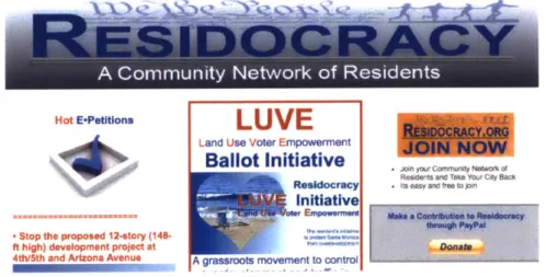
Figure 19. Homepage for Residocracy 34
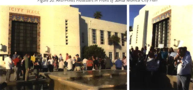
Figure 20. Anti-Hines Protesters in Front of Santa Monica City Hall 35
Figure 21. Pen Factory Site Plan 35
Figure 22. Artistic Renderings of Pen Factory 36
Figure 23. Comparison of Bergamot Transit Village and Pen Factory 37 Figure 24. Promotional Material for Residocracy's Land Use Voter Empowerment (LUVE)
Ballot Initiative 38
Figure 25. City of Newton Demographic and Housing Overview (2010) 42
Figure 26. Map of Newton Villages 42
Figure 27. Map of Newton Wards 43
Figure 28. Cover of 2001 Newton Framework Plan 45
Figure 29. Cover of 2007 Newton Comprehensive Plan 45
Figure 30. Newton Comprehensive Plan Projections for Full Housing, Employment
Figure 31. Newton Comprehensive Plan Base Case and High Case Scenarios for Increases in
Housing Stock by Typology 46
Figure 32. Newton Comprehensive Plan Identified Potential Development Sites 47
Figure 33. Artistic Rendering of Austin Street Project 48
Figure 34. Austin Street Project Site and Existing Conditions 49
Figure 35. View of Austin Street Existing Site 49
Figure 36. Cover of Austin Street Parcel Request for Information (RFI) 50
Figure 37. Cover of Joint Appointed Planning Group (JAPG) Report on Austin Street Parking Lot 50
Figure 38. Mixed Use Zoning Ordinance A-4 51
Figure 39. Cover of Request for Proposals 51
Figure 40. Site Plan for Austin Street Project 52
Figure 41. Artistic Renderings of Austin Street Project 53
Figure 42. Comparison of Original and Revised Austin Street Proposal 53
Figure 43. Homepages of the Newton Villages Alliance and the Friends of Austin Street 54
Figure 44. Friends of Austin Street Faux Newton TAB (Front): List of Supporting
Organizations and Individuals 55
Figure 45. Friends of Austin Street Faux Newton TAB (Back): Compilation of Letters to the Editor 55
Figure 46. Diagram of Research Findings 58
Figure 47. Diagram of LUCE and Bergamot Transit Village Process 61
Figure 48. Diagram of Newton Comprehensive Plan and Austin Street Project Process 63
Figure 49. Summary of Santa Monica and Newton Case Studies: Plan, Project and
Permit Processes 64
Figure 50. Diagram of Relationship Between Plan and Project 67
Figure 51. Diagram for Integrating Citizen Leadership in Planning Process 68
Figure 52. List of Committees Involved with Austin Street Project Approvals 69
Figure 53. Friends of Austin Street Homepage on Date of Austin Street Vote 69
Figure 54. Cover of Santa Monica Downtown Specific Plan Draft 71
Figure 55. MetroQuest Software Interface for Santa Monica Civic Auditorium Project 72
Figure 56. Options Available for Participant Selection in Santa Monica Civic Auditorium
MetroQuest Software 73
Chapter
1
Introduction
"The real difficulty is that "selling" the idea of planning and getting specific
planning measures into effect are two different matters."
-- ROBERT WALKER, THE IMPLEMENTATION OF PLANNING MEASURES
1.1 RESEARCH QUESTION
This thesis explores the relationship between plans and their implementation through development projects. Specifically, it asks: Do local plans that specify priority sites for development lead to the approvals of those projects? To answer this question, I look at the recent planning initiatives and their associated priority development projects in two cities - Santa Monica's Land Use and Transportation Element (LUCE) and Bergamot Transit Village project, and Newton's Comprehensive Plan and Austin Street project. Specifically, I look at the permitting process of each project to determine if the plans had any role in facilitating project approvals. While both cities' plans clearly identified sites for priority development, the outcomes of projects proposed on those sites differed. Given these results, I question the role of the plan in facilitating project implementation, and investigate other forces at play in the local development process that have a more definitive impact on project outcomes.
Figure i. Diagram of Research Question
PLAN PROJECT
1.2 CASE SELECTION RATIONALE: WHY SANTA MONICA AND NEWTON?
My objective was to study the effect that having a local plan that identified priority development sites had on the outcome of that project. I developed a set of criteria to select cities that could serve as illustrative case studies, including the following requirements:
* Must have recently adopted a local plan, with wide public and political support " Must have enumerated at least one priority development site in the plan
e Must have attracted a sponsor to propose a development for one of the priority sites identified in the plan
" Must have fully completed the approvals process for the proposed project
These criteria were the core characteristics needed to observe the outcomes related to my research question. Given these requirements, I selected the cities of Santa Monica, CA and Newton, MA
as illustrative case studies. Not only did they satisfy each of the above criterion, but they were also jurisdictions with which I was personally familiar and, for research purposes, able to physically access with relative ease.
1.3 METHODOLOGY
I utilized a qualitative research methodology that relied heavily on semi-structured interviews, policy review and document review. Interviews were conducted with individuals from three stakeholder groups - local community groups, city planners and project sponsors - for both case study projects. I spoke with local community groups in support and opposition to the projects to understand local awareness of plan priorities and determine whether the plan influenced their views in support or opposition of the project. I also spoke with city planners to learn about the planning process around both the plan and the project. Lastly, I spoke with project sponsors, consisting of developers and their investment partners, to find out if they relied on local plan objectives to marshal support for their project. A total of 20 interviews were conducted in person and over the phone between January and March 2016. Each interview lasted between 45 and 90 minutes. Other primary source documents for the Bergamot Transit Village project and Austin Street projects were accessed through materials provided on city websites and archives.
Figure 2. List of Interviewees
Name Organization Project / Topic Stakeholder Type
Peter James Senior Strategic Planner' Bergamot Transit Village City planner
__________________City of Santa Monica BegotTastVlge Cypanr
Planning Commission
Kyle Fersted Secretary, City of Santa Bergamot Transit Village City staff Monica
Varun Akula Hines 26th Street LLC Bergamot Transit Village Developer Christina Hill CSHV Pen Factory LLC Bergamot Transit Village Developer Dean Rotovsky CSHV Pen Factory LLC Bergamot Transit Village Developer Dan Herman Skidmore Owings and Merrill, LLC Bergamot Transit Village Architect Remy Monteko H R&A Advisors Bergamot Transit Village Consultant Jason Islas Editor, Santa Monica N ext Bergamot Transit Village Journalist
Jerry Rubin Resident Bergamot Transit Village Resident, community activist Armen Melkonians Founder, Residocracy Bergamot Transit Village Resident, community activist Rachel Blatt Urban Designer, City of N ewto n 28 Austin Street City planner
Jennifer Molinsky Former Senior Planner, 28 Austin Street City planner City of Newton
Figure 2. List of Interviewees (continued)
Name Organization Project / Topic Stakeholder Type
Alexandra Ananth Chief Planner, City of N ewto n 28 Austin Street City planner Chryse Gibson Oaktree Development 28 Austin Street Developer Scott Oran Dinosaur Capital Partners 28 Austin Street Developer Jennifer Van Campen Metro West Collaborative 28 Austin Street Developer
________________Development
Andrea Kelley Friends of Austin Street 28 Austin Street Resident, community activist Columnist,
Amy DainMagaine Puic policy 28 Austin Street Resident consultant; Resident
Robert Engler SEB, LLC 28 Austin Street Consultant
1.4 CHAPTER SUMMARIES
The preceding content in Chapter i frames my research question and research methods. In Chapter 2, I provide context around the role of discretionary review as it relates to plan implementation through development projects. This overview helps set up a framework for the case studies of Bergamot Transit Village in Santa Monica, CA and the Austin Street project in Newton, MA presented in Chapters 3 and 4. For each case, I review the local demographic context and municipal structure before providing an in-depth history of the city's plan and the success or failure of its associated development project. As part of the study, I include original data from 20 original interviews with resident and community groups, city planners and project sponsors. In Chapter 5, I discuss 2 specific political and legal mechanisms, voter referendum in Santa Monica and the politicization of the discretionary review process in Newton, that played a much larger role in each project's success or failure than the plan. Chapter 6 concludes with recommendations for cities endeavoring to more effectively bring the visions in their current or future plans to implementation.
Chapter
2An Overview of Discretionary Review in the Local
Development Process
This research looks at the effectiveness of plan implementation through the metric of specified priority development sites. Given that plans rely on zoning to govern development parameters and projects that exceed this baseline zoning are typically subject to discretionary review, I focus this literature overview on the various organization and procedures which relate to this discretionary review. My survey includes an examination of the independent planning board, the organization traditionally charged with discretionary review, and two forms of discretionary permits, the development agreement in California and the special permit in Massachusetts.
2.1 A BRIEF HISTORY OF THE INDEPENDENT PLANNING BOARD
As appointed bodies of citizen experts, planning boards are unique in local government as a non-elected body with considerable power over land use decisions and no direct consequence from
voters. Historically, planning board members have substantial professional experience in the building, construction and architectural industries and are valued for their ability to act as an independent
objective review board when making discretionary decisions. Though most local governments have a planning board, the question of their utility has been a topic of debate as early as the 1950s. Walker provides a concise critique. Arguing that a model of planning that relied on an independent body is inherently ineffectual, Walker advocated for replacing independent planning commissions with planning advisors reporting directly to the executive.2
If implementation were to be the ultimate goal,
then a direct connection between planning thought-leaders and the policymakers who would ultimately be responsible for implementation would be required.3 For Walker, planning boards, if merely "citizen
boards without political responsibility", would never be able to get past planning into implementation.
In response, Howard argued in ardent defense of the political and philosophical value of the planning commission.4 Presumably insulated from politics, an independent appointed body of perceived citizen-peers could "take the heat" or speak as the voice of objective review in a politically unpopular decision in a way that planning staff, the legislative body or the executive office could not. In this way, the independence of this body from the political sphere actually played an important political role.
Moreover, for Howard, the philosophical value of an "independent citizen commission" that gave material power to the public was irreplaceable. The citizen planning board literally operationalizing the principle that "[p]lanning should not be purely executive, nor purely legislative; it must be related to both, but also related directly to the private public."5
More than a decade following Walker and Howard's dialogue, Nash and Durden proposed a new framework for independent citizen planning board. Their new task-force approach phased out the traditional independent planning board that served regular terms in favor of "a flexible number of temporary citizens advisory boards" or 'task-forces."6 These short-term task-forces would be staffed
by appointed citizen experts, selected specifically for their talent in the particular planning issue of
study. The number of these bodies would adjust based on the needs of the city at the time, with potentially multiple bodies developing ideas for a variety of planning concerns in parallel. Similarly, the composition of these bodies would change based on the topic of study at hand. The overall object would be "to provide deeper local insights by raising and broadening the dialogues between the citizen expert and the resident planner and between any consultants and the citizens."7
argued that this system would retain the elements of real citizen participation that an independent planning board offered while resolving concerns over the inefficiency, duplication of roles, and political friction that planning boards were alleged to create.
Regardless of the form of the planning board, it is typically agreed that one of its major functions is to provide objective review of development projects seeking approvals. I now go into an overview of two types of approvals that are often sought, the development agreement in California and the special
permit in Massachusetts.
2.2 THE DEVELOPMENT AGREEMENT IN CALIFORNIA
In legal terms, a development agreement is a binding contract between two private parties, the city, a municipal corporation, and a private developer, regarding the terms by which a development project is to be accomplished. In 1979, California passed an enabling statute to become the first state to allow municipalities to enter into development agreements.'9 With over 700 development agreements adopted since, California is viewed as a leader in their use." The California statute considers the development agreement a legislative act, though this is not consistent across the other 15 states that have also adopted enabling statutes.'
Discussion of the development agreement should be preceded by an overview of discretionary review in land use regulation." Daniel Selmi provides a useful summary of the issues. While Euclidean zoning was first established to separate incompatible land uses, Selmi suggests that after time cities were faced with public pressure to address other social objectives, including environmentalism, economic development, design standards, historical preservation and combating housing discrimination, and saw land use regulations as a means to accomplish these ends.12 Selmi suggests that the outcome included a rise in informal bargaining as cities worked to achieve expanded social outcomes.13 In conjunction with this, other formal measures also increased the discretionary scope of the city. Planned Unit Developments (PUD), which became widespread in the 1950s, allowed developers to propose their own zoning within specified limits on a given parcel, then submit it to the city for review. PUDs prompted negotiation activity between city and developer to ensure that developers' likely biased initial proposals would not be unilaterally accepted. Within this context, development agreements emerged as another example of negotiating customized development parameters, but executed through the legal form of a contract.
The legal implications of contracts as they relate to zoning alone are well-reviewed, with courts repeatedly moving to curb municipal discretion. Durand v. IDC Bellingham (2003) decisively outlaws "contract zoning," the practice of a municipality "[bargaining] away" its police powers outright in exchange for beneficial zoning granted to a private developer. 14 Additionally, prior to Durand, the
rulings of Nollan v. California Coastal Commission (1987) and Dolan v. City of Tigard (1994) had already
dampened municipal negotiating power, requiring that "essential nexus" and "rough proportionality" exist between the exactions requested from developers and their project impacts, with the burden of proof falling on the city.15,6 While the case law doesn't explicitly prohibit the ability of cities to
negotiate, it puts bounds on what material benefits can be bargained for, limiting the ability of the city to achieve optimal public benefits.
i
Or across other cases of the use of development agreements in states without explicit enabling statues. Kent, Michael B. (2006). Forming a Tie That Binds: Development Agreements in Georgia and the Need for Clarity. Environs: Environmental Law and Policy Journal. Volume 30. Number 1.In contrast to the contract zoning specifically prohibited by the courts above, the voluntary, consensual nature of a development agreement contract permits the city to negotiate more flexibly across
development parameters, including those typically encompassed by the zoning code. Thus, the development agreement, as a contract between two private parties, treads a special territory between public and private interest that provides the city with wide discretion around development terms.
2.3 THE SPECIAL PERMIT IN MASSACHUSETTS
While the above discussion reviewed the role of development agreements, particularly in California, as a broad discretionary tool applied separately from baseline zoning, this next section focuses on the special permit in Massachusetts, a tool codified within the zoning code that also permits wide discretionary review.
The most basic scope of zoning is composed of a zoning code and map which together designate the geographical extents of districts and enumerate their associated allowable uses. Together, these two tools guide the type of development desired in each area of the city, though they may be updated and revised as a city adopts new directions for growth." Proposed projects that are consistent with the uses outlined in the code are given "by-right" administrative approvals. In Massachusetts, projects seeking approval of uses not permitted by baseline zoning may elect to seek a special permit through a discretionary process overseen by the municipality's Special Permit Granting Authority.
Given the rigid nature of Euclidean zoning, the special permit fills the gap between uses that are permitted by-right and uses that may fulfill the spirit of the ordinance, but necessitate special review to as to ensure appropriate mitigation of impacts. Massachusetts General Laws Chapter 40A, )9 clearly states that special permits may be issued for uses "which are in harmony with the general purpose and intent of the ordinance or by-law." Newton's zoning ordinance further states that "[t]he Board of Aldermen may grant a special permit when, in its judgment, the public convenience and welfare will be served, and subject to such conditions, safeguards and limitations as it may impose."17 In SCIT v. Planning Board of Braintree (1984), the courts reaffirmed the important role that special permits play in zoning:
"The role of the special permit in land use planning is not something new. Special permit procedures have long been used to bringflexibility to thefairly rigid use classifcations of
Euclidean zoning schemes.. .by providingfor specific uses which are deemed necessary or desirable but which are not allowed as of right because of their potentialfor incompatibility
with the characteristics of the district."
Not only do statutory law and case precedent clearly establish the purpose of special permits, state law also clearly requires that the uses for which a special permit may be granted also be fully outlined in the zoning ordinance. These uses are to be distinct from the right uses, but fully spelled out in local by-laws along with any other requirements necessary for approval.
Even with requirements for special permit approval codified by ordinance, the granting of a special
ii Some cities, such as Boston, are known to strategically keep their zoning outdated that is, "underzoned" compared to the actual desired level of development, to put the city in a stronger position when it comes time to
permit remains a fully discretionary process. That is, fulfilling the requirements of a special permit does not require that one must be granted.9 Complete discretion is given to the special permit granting authority in evaluating a proposal in relationship to specified requirements, but the SPGA is justified in denying the permit even if these requirements are satisfied. Case law repeatedly affirms this:
"The merefact that the standards setforth are complied with does not compel the granting of a special permit..." 20
"[T]he board, in the proper exercise of its discretion, isfree to deny a special permit even if the facts show that such a permit could be lawfully granted." 21
"...[R]efusal to grant a special permit does not require detailed findings... The granting authority has thefull range of discretion in shaping its decision. Neither the Zoning Enabling Act nor the town zoning by-law gives.. .an absolute right to the special permit... The board is not compelled to grant the permit." 22
In practice and by statute, the special permit is a discretionary exercise, wholly dependent on the review and affirmative vote of the city's special permit granting authority.
1 Robert A. Walker (1950) The Implementation of Planning Measures, Journal of the American Institute of Planners, 16:3, 122-130, DOI: 1o.1o8o/o1944365008979287
2 Ibid.
3 Ibid.
4 John T. Howard (1951) In Defense of Planning Commissions, Journal of the American Institute of Planners, 17:2, 89-94, DOI: 10.1080/01944365108979319
5 Ibid.
6 Peter H. Nash & Dennis Durden (1964) A Task-Force Approach to Replace the Planning Board, Journal of the American Institute of Planners, 30:1, 10-22, DOI: 10.1080/01944366408978084
7 Ibid.
8 Smith, B. (1988). California Development Agreements and British Planning Agreements: The Struggle of the Public Land Use Planner. The Town Planning Review, 59(3), 277-287.
9 Cal. Gov't Code $ 65868.5
10 Curtin, Daniel
J.
Property Development Agreements in an Era of Smart Growth Legislation. Real Estate Law. Volume 18. Number 2. March 2001.11 Selmi, Daniel P., Land Use Regulation by Contract (December, 14 2009). Loyola-LA Legal Studies Paper No. 2009-51.
12 Ibid.
13 Ibid.
14 Durand v. IDC Bellingham, LLC, 793 N.E.2d 359, 366 (2003).
15 Nollan v. California Coastal Commission. 483 U.S. 825 (1987)
16 Dolan v. City of Tigard. 512 U.S. 687 (1994)
17 Newton Zoning Ordinance Chapter 30. 7.3.3 Grant of Permit.
18 SCIT v. Planning Board of Braintree, 19 Mass. App. Ct. 101, 109 (1984)
19 Humble Oil & Refining Co. v. Board of Appeals of Amherst, 360 Mass. 604, 605 (1971)
20 Ibid.
21 Pioneer Home Sponsors, Inc. v. Board of Appeals of Northampton, 1 Mass. App. Ct. 830, 831 (1973 22 MacGibbon v. Board of Appeals of Duxbury, 369 Mass. 512, 515 (1976)
Chapter
3
A Case Study of Santa Monica, CA
This chapter moves from the overview of discretionary review in the local development process provided in the previous chapter to its application in two cities. In Santa Monica, CA, the city's 2010
Land Use and Circulation Element (LUCE) identified priority development sites, among them the site for what would become the most contentious project in the city's recent history, the Bergamot Transit Village. Similarly, in Newton, MA, the city's 2007 comprehensive plan also enumerated potential
development sites and initiated a process by which one of the identified parcels became the site for the Austin Street project, which would also polarize the city. In both cities, the projects were direct
outgrowths of plans that explicitly identified development sites, however, they ultimately experienced different outcomes. After 8 years of project development and community process, the Bergamot Transit Village was denied its approvals and abandoned by its project sponsor. On the other hand, the Austin
Street development, after facing its own 7-year contentious community process, was ultimately granted its approvals.
To better understand what role, if any, the plan had in facilitating these projects' outcomes, I undergo a review of each city's local governance structure, planning process and outcome of each corresponding project.
3.1 DEMOGRAPHIC OVERVIEW
Santa Monica is a small, dense city of 92,987 residents located about 15 miles west of downtown Los Angeles. With the Pacific Ocean to the west, Santa Monica bounded by the City of Los Angeles on all other sides, namely by the affluent neighborhoods of Pacific Palisades and Brentwood to the north, Sawtelle and Mar Vista to the east and Venice to the south. As a residential neighborhood, Santa Monica has 46,439 households, over 72% of whom are renters. About 77% of the city's 50,912 housing units are in multi-unit structures.2 Santa Monica has a median household income of $73,439, which
ranked loo out of Los Angeles County's 272 communities in median household income in 2000.3 The city is composed of seven neighborhoods and a Downtown commercial area. The Interstate 10 freeway
bisects the city, running through the center of the Mid-city neighborhood and terminating in the Downtown area. The major east-west boulevards (from northernmost to southernmost) are Montana Avenue (neighborhood commercial), Wilshire Boulevard (mixed-use), Colorado Boulevard (low-rise
mixed-use), and Pico Boulevard (neighborhood commercial). The major north-south corridors are Lincoln Boulevard and the California State Route i Pacific Coast Highway.
Santa Monica's relationship with Los Angeles has been a recurring force in shaping the social identity of the city. As one of the original streetcar suburbs of Los Angeles, Santa Monica essentially became a resort destination overnight after track was laid to connect the seaside town to LA's downtown in the
1870s. Soon after, the residents of the settlement voted to incorporate as a city in 1886 and the city grew steadily through the 1920s, developing hotels, amusement piers and other beachfront attractions to attract visitors from Los Angeles. A burgeoning aerospace industry carried the city's economy and jobs base through the postwar period, but the city struggled economically during the 1960s and 70s,
due in part to the rise of highways, cars and the exodus of the middle class. However, in the 1980s, a hugely successful redevelopment campaign repositioned a failed mall into what is now the Third Street Promenade, an open-air mixed-use upscale commercial corridor that quadrupled the city's revenues
Figure 3. City of Santa Monica Demographic and Housing Overview (20o0)
Population
(2014 estimate)Population, percent change from 2010 to 2014
White alone
Black or African American alone Asian alone
Hispanic or Latino alone Two or more races Other
Total housing units Total households
Homeownership rate, 2009-2013 Housing units in multi-unit structures Median household income, 2009-2013
Median value owner-occupied housing units, 2009-2013 Persons below poverty level, percent 2009-2013
Land, square miles Persons per square mile
92,987 +3. 6% 77.6% 3.9% 9.0% 13.1% 4.4% 0.5% 50,912 46,439 27.4% 77.0% $73,649 $999,900 11.2% 8.42 10,664
between 1988 and 1999, and jumpstarted the city's economic health.s The 1990s saw strong growth in
the commercial office sector clustered in the Mid-City neighborhood, while the 2000S saw the rise of a tech sector in Santa Monica's Downtown neighborhood. Despite this growth and the city's location adjacent to Los Angeles, the 2nd largest city in the country, a popular perception exists in the city that it is still a "sleepy beach town" akin to the stagnation that occurred in the 1970s'
Figure 4. Map of Santa Monica Neighborhoods
f
r
4.K:
1711,/ /T El /While the city saw strong development and commercial growth in the past few decades, the
relationship between the city's progressive resident base and the city's pro-business community was not always harmonious; attitudes toward growth have shifted and evolved with the times. Tending toward progressive politics, each of seven neighborhoods currently operates its own neighborhood
association. The city also has its own local political party, Santa Monicans for Renters' Rights (SM RR), which was formed in 1978 by local residents that organized to fight rapidly escalating rents. The party
was successful in influencing the passage of the city's rent control law in 1979, and has since played a significant role in local politics to actively uphold rent control and strongly discourage development in the city.7 In 1981 and 1989, SMRR was able to effectively use its majority position in the City Council to
institute an outright moratorium on commercial developments.8
Parallel to this activism, Santa Monica began to be perceived as a difficult place to do business or development, even prompting the Chamber of Commerce to form a blue-ribbon task force in 1986 to study the city's economic climate and devise strategies to counteract this perception.9 However,
the resulting report, which recommended policies ranging from permit streamlining to priority development projects to jump-start confidence in the city's local economy, was never voted on by the
City Council. A member of the task force representing the business community at the time claimed that this was because "[the City Council] might eventually have to act on the report as part of their official
duties."
This broad overview of Santa Monica's urban form, history and politics illustrates a local context in tension with its historic identity as a "sleepy beach town" and more recent runaway success as a hub of commercial development. I now go into a close study of Santa Monica's local policy and governance context, its 2010 Land Use and Circulation Element (LUCE) plan, and the outcomes of the Bergamot Transit Village.
3.2 THE LOCAL POLICY AND GOVERNANCE CONTEXT
Santa Monica is a charter city that has operated under the Council-Manager form of local government
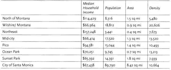
Figure 5. Demographic Overview of Santa Monica Neighborhoods (2010) Median
Household Population Area Density
Income
North of Montana $114,429 8,316 1.5 sq mi 5,48o
Wilshire/ Montana $66,964 18,812 0.9 sq mi 20,606 Northeast $157,248 3,441 0.4 sq mi 7,673 Mid-city $66,414 17,520 1.3 sq mi 13,520 Pico $54,581 15,044 1.4 sq mi 10,493 Ocean Park $70,251 9,745 0.7 sq mi 13,213 Sunset Park $65,392 14,391 1.8 sq mi 7,939
since 1945.' The City Council is composed of seven councilmembers elected at-large who serve four year terms. Every two years, the City Council selects one of its members to serve as the Mayor and another to serve as the Mayor Pro Tempore for the next two years.", The Planning Commission was established by the city's 1946 charter and acts "to promote the health, safety and general welfare by encouraging the most appropriate use of land" in the city.' Per Santa Monica Municipal Code Section
loo8, the Commission has four responsibilities:
1) After a public hearing, recommend to the City Council the adoption, amendment or repeal of a plan related to the physical development of the city
2) Oversee land subdivision
3) Make recommendations on public works or urban renewal projects 4) Exercise any functions pertaining to zoning as required by ordinance
Within this framework, the roles of the three bodies involved with regulating development in the city
- the city planning department known as Planning & Community Development (PCD), the Planning
Commission, and the City Council - are complementary and well-defined. On a day-to-day basis, city planners are the main point of contact for engagement work, and also serve a technical advisory capacity to support the Planning Commission in plan and project review.
On the other hand, the Planning Commission primarily reviews plans and larger development projects as required by ordinance. Upon review of planning documents, the Planning Commission makes a recommendation to the City Council for adoption or amendment. Upon review of development projects, the Planning Commission grants or denies permits. Lastly, the City Council as the local legislative body votes to officially adopt the plans that have undergone PCD and Planning Commission review. Importantly, the City Council does not have authority to grant development permits outright.'
3-3 THE PLAN: THE LAND USE AND CIRCULATION ELEMENT (LUCE)
"The LUCE places Santa Monica at theforefront of sustainable planning practices." -- - SANTA MONICA LAND USE & CIRCULATION ELEM ENT 2010
In July 2004, the Santa Monica City Council initiated the process to prepare an update to the Land
i Nearly half of the cities in the U.S. with populations of 2,500 or more operate as a Council-Manager form
of government, in which a governing body is elected and a manager is hired by that body to carry out the policies it establishes. "A Brief History of Santa Monica and its Charters." Santa Monica City Council. www.smgov.net.
Retrieved March 29, 2016.
ii Per Santa Monica City Charter art. X ioo8, the Planning Commission acts also to "provide adequate open spaces for light and air; prevent undue concentrations of population; lessen congestion on streets; facilitate adequate provisions for community utilities and facilities such as transportation, water, sewage, schools, parks and other public requirements; and, designate, regulate and restrict the location and use of buildings, structures and land for residents, commerce, trade, industry and other purposes."
iii The City Council, however, hears permit appeals cases. Interview with Kyle Ferstead, Santa Monica Planning Commission Secretary. March 30, 2016.
Use element of their general plan.' By the end of the year, the scope had increased to include both the Land Use and Circulation elements into one plan. After a six year planning process, the LUCE was unanimously adopted by the City Council in July 2010 as the first update of these elements from the City of Santa Monica General Plan since 1984.
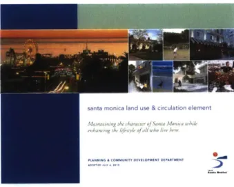
Figure 6. Cover of the Santa Monica 207o Land Use and Circulation Element (LUCE)
. a lind use & ciculation ernent
According to city planning staff, the LUCE was the most ambitious plan ever adopted by the city.' The LUCE "set forth a twenty year vision for the entire City" encompassing land use, transportation, housing, environmental, open space and commercial mixed-use issues in a Soo+ page comprehensive and progressive smart growth planning document. Among its many outcomes, the LUCE utilized three planning tools - land use regulations, specific plans for priority development sites and entitlements reform - to implement its planning priorities. First, the LUCE called for changes in land use that would "preserve existing land uses and density in 96% of the city, while focusing new development along transit boulevards and near three Expo light rail stations."4 In essence, 4% of the city's area was upzoned for development while 96% of the city was preserved. Limiting upzoning to areas along commercial boulevards had the dual purpose of "[redirecting] residential market pressure away from existing neighborhoods" and reinforcing the vitality of the city's existing commercial streets through
enhanced pedestrian traffic."
Second, the LUCE commissioned a series of updated Specific Plans and new Area Plans to implement
LUCE priorities in particular areas of the city." One of the new area plans called for by the LUCE was
the Bergamot Transit Village Area Plan, which was charged with "[establishing] a new neighborhood focused around the Bergamot Light Rail Station and including expanded housing opportunities, local-serving retail uses, creative arts, employment, and consolidated parking in a small grid network of streets and pedestrian pathways."" In meetings to envision the future of the city's industrial lands,
iv California state law requires every local jurisdiction to maintain a General Plan to guide city growth, land use, infrastructure and planning for city services. The state requires that the plan consist of seven specific "elements" or subject categories, including land use, circulation, housing, conservation, open-space, noise and safety. General Plan Guidelines. State of California. Governor's Office of Planning and Research. October 2003.
www.opr.ca.gov
v State law (California Government Code Section 63450) authorizes cities to adopt Specific Plans to implement their General Plan in designated areas of the city.
M
community members endorsed the Bergamot Station area as a top priority development site. Once a historic Pacific Electric rail station that connected the city to downtown Los Angeles until the 1950s,
Bergamot Station had been re-envisioned in the 1990s as an art gallery complex that retained its former industrial character.: Now a popular cultural and tourist destination with over 6oo,ooo visitors annually, the pending addition of a new MBTA light rail station at the site expected in 2016 provided the chance for existing creative commercial uses to be enhanced with residential and other mixed uses."
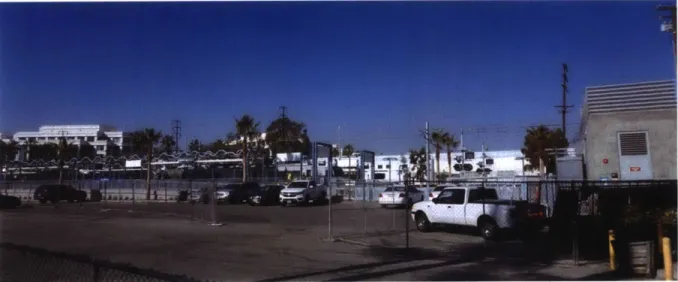
Figure 7. Bcrgarnot Light Roll Station Existing Conditions
VSI
Lastly, the LUCE formalized a system of Tiers for permit review in most areas of the city. Once adopted, Tier I would allow for "by-right" development of baseline FAR and height through a non-discretionary
process for projects under 7,500 square feet. Tier
11
would grant additional FAR and height with the approval of a discretionary permit and the provision of community benefits. Tier Ill would allow for still more FAR and height with approval of a Development Agreement and the provision of additional community benefits. By incentivizing developers to work closely with the city in order to be grantedthe more development rights, the Tier system aimed to leverage the strong market of the city to extract the most community benefits possible for the public.
The process for creating the LUCE was extensive. Six years passed between the initial motion of the City Council in 2004 to the formal adoption of the plan in 2010. During this time, city staff facilitated
25 public hearings before the City's Boards, Commissions and City Council, 12 community workshops, numerous Internet and phone surveys, and on-site walking tours.- Eighteen public hearings took place before the LUCE Strategy Framework alone. These public hearings were often televised to reach an at-home audience.' Overall, an estimated 4,000 residents of all ages were directly involved in some capacity through this outreach:
Over the six-year process, the bulk of community workshops took place between 2007 and 2010.
About 1,000 community members attended the initial placemaking workshops that were initiated
in 2007. The outcome of these initial workshops was a set of community values that focused on
preserving neighborhood character, creating community places and providing community benefits. In subsequent community workshops in 2008, topics such as the future of industrial lands, transportation
and the city's boulevards were the focus of discussion. Later workshops in 2008 to 2009 integrated these concepts into a framework of land use guiding principles and additionally focused on specific
locations, the Downtown and Civic Center complexes, to envision principles for redevelopment and steps for implementation. The Land Use Guiding Principles included 5 broad land use categories and their goals, including neighborhoods, boulevards, mixed-use centers, local employment and commerce
uses, and community and public uses. In April 2010, the Draft LUCE was completed and presented to the public for review.
Figure 8. List of Major Community Workshopsfor LUCE Between 2007-2010
Workshop Focus Date Priorities
1. Preserving neighborhood character Initial Placemaking Early 2007 2. Creating community places
3. Providing community benefits were determined
1. Locate new neighborhood centers in areas served by Industrial Lands Sat 6/21/2007 2. transit
n #2 Tad 1/2/2007 tBergamot Transit Village: Focus on Arts and Sustainability #1 &Thu 0/25/2007 3. Memorial Park: A Central Park within a New Urban
Neighborhood Sat 10/6/2007
1.
Minimize congestionTransportation Thu 12/6/2007 2. Regain pedestrian control over city streets
#1, #2 & #3 Sat 3/1/2oo8 3. Reduce dependency on car
4. Commit to goal of No Net New Trips
Boulevards Sat 2/9/2008 1. Recognize that streets do more than just move cars 2. Have streets that provide complete experiences
1. Balance economic viability with community benefits Integrating the Plan Wed 4/2/2008 2. Focus on new housing opportunities: affordable,
workforce, family, senior, congregate housing Downtown and Civic Mon 5/11/2009 (Meeting documentation unavailable)
Center
EIR (Environmental
1.
Determine scope of issues to be reviewed in EIR, as Impact Report) Mon 5/18/2009 required by California Environmental Quality Act (CEQA) ScopingNeighborhood Sat 6/6/2009 1. Protect existing housing stock
Conservation 2. Appropriate transition in building scale and height
1.
Affordable and workforce housing 2. Open spaceTaking Charge of Our Tue 7/7/2009 3. Creative arts
Future 4. Historic preservation
5. Traffic demand management
6. Programming for children, teens & seniors Draft LUCE Wed 4/7/2010 Presentation of Draft LUCE to public
After an additional 13 public hearings with the Planning Commission and City Council, the final
LUCE was unanimously approved and adopted by the City Council in July 2010. The update to the
zoning ordinance that implemented the LUCE citywide occurred in June 2015. In parallel, the city initiated planning processes to update and create the new area plans commissioned by the LUCE. The
Bergamot Area Plan was among the first of these initiatives. In November 2010, the city was awarded a competitive $625,000 grant through the HUD/TIGER 11 Sustainable Communities Challenges, a collaboration between HUD-DOT-NEA federal agencies aimed at encouraging compact, mixed-use
development linked to transit.- Synergy in timing and vision allowed for this grant to be utilized in support of the planning process for the Bergamot Area Plan, which itself took another 3 years. After 5 community workshops, 4 neighborhood meetings, 5 Planning Commission meetings and 2 City Council hearings, the Bergamot Area Plan was adopted by the City Council in September 2013 by a 6-i vote.
Figure 9. Cover the Santa Monica 2013 Bergamot Area Plan
Figure 10. List of Major Meetingsfor Bergamot Area Plan Between
2011-2013-Meeting Type Workshop #1 Workshop #2 Workshop #3 Workshop #4 Workshop #5 Neighborhood Meeting #1 Neighborhood Meeting #2 Neighborhood Meeting #3 Neighborhood Meeting #4 Planning Commission #1 Planning Commission #2 Planning Commission #3 Planning Commission #4 Planning Commission #5 City Council Hearing #1 City Council Hearing #2
Date Thu 2/17/201 Wed 7/13/2011 Wed 12/7/2011 Tue 2/7/2012 Mon 4/23/2012 Mon 10/10/2011 Tue 10/11/2011 Thu 10/13/2011 Mon 11/28/2011 Wed 5/16/2012 Wed 5/16/2012 Wed 2/13/2013 Wed 2/20/2013 Wed 6/12/2013 Tue 3/12/2013 Tue 9/10/2013 Agenda
Bergamot Transit Village #1
Creative Economy
Bergamot Transit Village #2 Community Benefits Designing the Districts Local Westside Artists
Bergamot Station Gallery Owners Pico Neighborhood Association Bergamot Businesses
Preliminary Framework Core Components of the Plan Draft Plan
Draft Plan (continuation) Review Final Draft Draft Bergamot Area Plan Bergamot Area Plan Adoption
While the LUCE was aimed at citywide strategies, formerly industrial 142.5 acre site located next to t The 270-page plan included land use regulations,
the Bergamot Area plan focused exclusively on the he new Bergamot Light Rail Station expected in 2016.
design guidelines, street design standards, and steps for implementation to execute 6 core components of the plan through a io guiding principles. Most importantly, the plan created 4 new land use districts - the Bergamot Transit Village (BTV), Mixed-Use Creative (MUC), Conservation: Art Center (CAC) and the Conservation: Creative Sector (CCS) - to coordinate new growth as well as protect existing creative uses on-site. As established by the LUCE, the plan outlined height and FAR regulations for each Development Tier. Regulations pertaining to
Tom
K
iv Id
FI"_-the Bergamot Transit Village (BTV) District outlined below demonstrate -the increase in buildable density allowable in exchange for increased discretionary review and extraordinary community benefits provided. The plan also provided detailed design guidelines for buildings, open space and complete streets that incorporated multimodal transportation along the parcel's main boulevards.
Figure ii. Location of Bergamot Area Plan within City of Santa Monica.
)
STSANTA MONICA
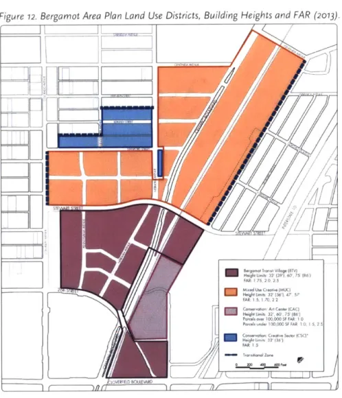
Figure 12. Bergamot Area Plan Land Use Districts Building Heights and FAR (2013).
U-1,
32
(316_
/A
22
/7AftC -t,(A,3 0 516 1000FA R
Figure 13. Major Development Standardsfor Bergamot Transit Village (BTV) District
Tier I Tier // Tier III
Baseline Discretionary Permit Development Agreement
Mix of uses Commercial (60%), Residential (40%) for all Tiers
32' (UP to 39' if 675' (up to 86' if ground
Height Limit
ho'using
is3'cluded) 6o' floor-to-floor is increased from 13.5' to18.5ft)
FAR 1.75 2.0 2.5
Max Floor Plate 35,ooosf for all Tiers
Min Open Space
>8o,ooosf 20% 20% 25%
40,ooo-8o,ooosf 15% 15% 20%
<40,ooosf 10% 10% 15%
Min Size of Primary Open Space 4,ooosf 4,ooosf 6,ooosf
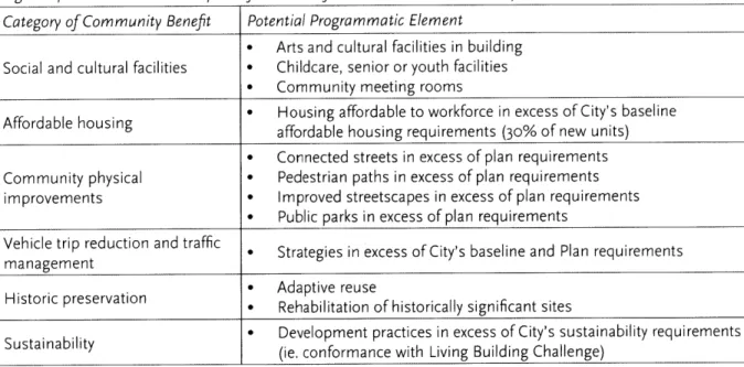
Figure 14. Potential Community Benefits Neededfor Tier // and Tier I/ Developments Category of Community Benefit Potential Programmatic Element
* Arts and cultural facilities in building Social and cultural facilities * Childcare, senior or youth facilities
* Community meeting rooms
Affordable housing Housing affordable to workforce in excess of City's baseline affordable housing requirements (30% of new units) * Connected streets in excess of plan requirements Community physical * Pedestrian paths in excess of plan requirements
improvements * Improved streetscapes in excess of plan requirements
* Public parks in excess of plan requirements
Vehicle trip reduction and traffic * Strategies in excess of City's baseline and Plan requirements
management
H Adaptive reuse
Historic preservation * Rehabilitation of historically significant sites
Sustainability * Development practices in excess of City's sustainability requirements
(ie. conformance with Living Building Challenge)
From an implementation perspective, the Bergamot Area Plan was the first tangible step towards realizing a major anchor project set forth in the LUCE. In essence, the Bergamot Area Plan operationalized LUCE principles to a real-world transit-oriented development-ready site with the support of a cross-sectoral resident, employee and business community base. In the city's densely developed fabric, the Bergamot area was the largest site left for development in the city and presented an opportunity to implement the LUCE's new development norms in the city. Not only that, but as early as 2010, there was already friendly developer interest in the site and, in the words of the Bergamot Area Plan, the plan was "not designed to sit on a shelf." Leveraging developer interest with the plan's new development tiers and community benefits requirements seemed like natural way to ensure a strong start to the LUCE and Bergamot Area Plan's implementation.
3.4 THE PROJECT: THE BERGAMOT TRANSIT VILLAGE
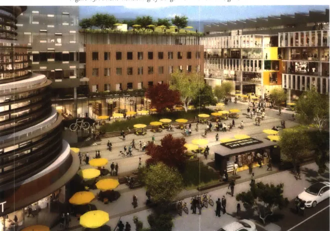
Figure 15. Atistic Rendering of Bergarot Trorsit Villoge Urban Plaza
-- 4
vgr-mrg I
r aan
--
410
Mg
"This is direct democracy in action...This is the power of Residocracy and our
Hammer of Strength."
-- -ARMEN MELKONIAN, FOUNDER, RESIDOCRACY.ORC 2 7
"This site
wvaservisionedfor much more than
what we're
going to make it."
-- - DEAN ROTOVSKY, CLARION PARTNERS
"We
were
too caught up in the trend."
--- PETER JAMES, SENIOR PLANNER, CITY OF SANTA MONICA
Hines, a Texas-based developer with national reach, was not a newcomer to Santa Monica. Since 1998, Hines had been involved with the renovation and expansion of the Lantana Media Campus, located directly north of the Bergamot Transit Village site." For the Lantana, Hines underwent a 5 year entitlements process, triggering a Tier Ill Development Agreement that eventually required over $2 million dollars in community benefits agreements-in exchange for the right to expand the existing
344,000 square feet of creative office space by an additional 194,000 square feet.-) The successful execution and leasing of this project yielded Hines a price of over $310 million upon sale of the complex
In 2007, in the midst of the Lantana process, Hines acquired a 7-acre parcel, the site of the former Papermate factory, located adjacent to the Lantana. The site featured an existing 206,000 square foot factory building and surface parking lots used by the pen manufacturer. Given concurrent LUCE community workshops and Hines' experience with the city's Development Agreement process, the site seemed like an ideal location to build off of the Lantana's success and the city's new development priorities. According to Project Manager Varun Akula, Hines was confident they "knew the city process and thought [they] could leverage it."
I m
y
i1
R
I,T
As early as 2009, Hines engaged the surrounding community before approaching the Planning
Commission and City Council in a series of preliminary "float up" meetings from 2010 to 2011. At the time, the initial scheme proposed office alone, but Akula remarked that they "worked with the city" to come up with a higher density proposal in light of emerging priorities from the LUCE Formal
Planning Commission review
of the final began
in late
2Q13 and extended into the next year, until the permit application was ultimately narrowly approved in February 2014 by a 4-3 vote. Akula noted that the contentious final public hearing before the City Council ended at 2am and featured comments fromover
100 community members, 65 inopposition
and 30 in support.Utilizing a Tier
Ill
Development Agreement, the approved Bergamot Transit Village project consisted of a total of 765,000 square feet, with a mix of about 40%o residential and 60%0 commercial space, including 473 residential rental apartments, 25 artist live/work units, 374,000 square feet of creative office, about 15,500 square feet of restaurant space and 14,000 square feet of retail space over 3 residential buildings, 2 commercial buildings, 4 acres of open space, 2 acres of parks, paseos andplazas, 2 acres of sidewalks and streets and a main 31,675 square foot central publc plaza. The unit mix featured predominantly studios (211 units) and 2 bedrooms (i56 units), with substantial numbers
of
1
bedrooms (93 units) and some 3 bedrooms (13 units). The entire complex provided a total of 1,924underground parking spaces and 1,284 bike spaces on-site. With an FAR of 2.5 and maximum height of
85'6", the project was in compliance with Development Tier


![[DOC] Les Feuilles de Style cours | Télécharger PDF](data:image/gif;base64,R0lGODlhAQABAIAAAP///wAAACH5BAEAAAAALAAAAAABAAEAAAICRAEAOw==)