Vegetation History
and Archaeobotany
@ Springer-Verlag 2000
Four thousand years of plant exploitation in the Chad Basin of
northeast Nigeria I: The archaeobotany of Kursakata
M a r l i e s K i e e L, B a r b a r a Z a c h 2 and K a t h a r i n a N e u m a n n 2
Universitaet Basel, Botanisches Institut, Schoenbeinstrasse 6, CH-4056 Basel, Switzerland
2 Seminar ftir Vor- und FriJhgeschichte, Arch~iologie und Archfiobotanik Afrikas, Johann Wolfgang Goethe-Universitfit Frankfurt, Robert-Mayer-Str. 1, D-60325 Frankfurt, Germany
Received January 13, 2000 / Accepted June 19, 2000
A b s t r a c t . This paper discusses archaeobotanical remains from the s'ettlement mound of Kursakata, Nigeria, com- prising both charred and uncharred seeds and fruits as well as charcoal. In addition, impressions of plant tempering material in potsherds were analysed. The late Stone Age and Iron Age sequence at Kursakata is dated from 1000 cal. B.C. to cal. A.D. 100. Domesticated P e n n i s e t u m (pearl millet), wild Paniceae and wild rice are the most common taxa. Kernels f r o m ' t r e e fruits were regularly found including large numbers of Vitex simplicifolia - a tree which is absent from the area today. A distinct change in plant spectra can be observed between the late Stone Age and the Iron Age. Although domesticated pearl millet was already known at the beginning of the settlement se- quence of Kursakata, it only gained greater economic im- portance during the Iron Age. Besides farming, pastoral- ism and fishing, gathering of wild plants always played a major role in the subsistence strategy of the inhabitants of Kursakata. The charcoal results show that firewood was mainly collected from woodlands on the clay plains, which must have been more diverse than today. The end of the late Stone Age in the Chad Basin was presumably accom- panied by the onset of drier environmental conditions from ca. 800 cal. B.C. onwards.
K e y w o r d s : Prehistoric West Africa - Domesticated
Pennisetum - Wild cereals Charcoal - Palaeoecology
(1996), Klee and Zach (1999) and Neumann (1999a). In- vestigations have concentrated on two ecologically differ- ent areas (Fig. 1), first the Chad Lagoonal Complex (or
f i r k i clay plains) and secondly the Bama Deltaic Complex
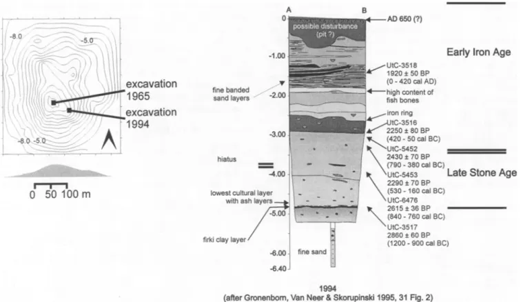
(Aitchison et al. 1972). In the sixties, the f i r k i were the object of intensive archaeological investigations con- ducted by Connah (1976, 1981). In 1965, Connah exca- vated a test trench at Kursakata down to a depth o f 6.40 m (Connah 1981). In 1994 we revisited the site mainly in or- der to obtain additional archaeobotanical and archaeo- zoological data.
The Chad Basin plays an important role in theoretical considerations of early African agriculture. Harlan (1971) included the Chad Basin in his hypothetical domestication area o f several indigenous African crops, such as
Pennisetum glaucum (pearl millet), Sorghum bicolor and
Oryza g l a b e r r i m a (African rice). However, this hypoth-
esis was mainly based on the modern distribution of the cultigens' wild ancestors and not on archaeobotanical data, which in general are very sparse for the whole African continent. Our investigations at Kursakata are the first comprehensive archaeobotanical study in the Chad Basin, and their aims are as follows: first to test Harlan's hypoth- esis, secondly to provide information on subsistence strat-
I n t r o d u c t i o n
Kursakata is a settlement mound in the Chad Basin o f northeast Nigeria, situated at the northern edge of an ex- tensive fiat clay plain @'rki). The Nigerian Chad Basin is one of the main study areas of a Joint Research Project of the Universities of Frankfurt, Germany and Maiduguri, Nigeria. Archaeological and archaeobotanical overviews are given by Breunig et al. (1996), Breunig and Neumann (1999), Gronenborn (1996, 1998), Gronenborn et al.
Fig. 1: The stud}' area: NE Nigeria, the Chad Basin southwest of
egies and to determine when agriculture started in the re- gion and thirdly to contribute towards a reconstruction of the palaeoenvironment and palaeoclimate.
This article is the first in a series of forthcoming publi- cations which will present archaeobotanical results from several archaeological sites in the Nigerian Chad Basin excavated by the joint research project.
T h e e n v i r o n m e n t
Palaeoclimate and geology
The investigated area is located in the southwestern part of the Chad basin between Lake Chad and the Bama Ridge (Fig. 1). The Bama Ridge is a fossil beach ridge built up during the early and middle Holocene wet phase, when the lake level was about 40 m higher than today (Servant 1983). After 5000 B.P., Lake Chad shrank as a result of increasing aridity (Thiemeyer 1992, 1993). This aridifi- cation trend has also been recorded in pollen diagrams from the Manga grasslands 200 km to the west (Salzmann and Waller 1998). Following the regression of Lake Chad, the southwestern plains of the basin became accessible in the late Holocene, the Bama Deltaic Complex around 1800 B.C. and the Chad Lagoonal Complex towards the end of the second millennium B.C. (Breunig and Neumann 1999).
The sediments of the Chad lagoonal complex consist of heavy clays called firki which presumably have been de- posited by the retreating lake behind the Ngelewa Beach Ridge (Thiemeyer 1997). In the dry season, cracks more than one metre deep are formed in the soils. During the rainy season, the plains are almost completely flooded, with only a few elevated dry sandy hills allowing human settlement. In this way, settlem'ent mounds with a height of up to 8 m have been built up in the course of the last 3000 years. The settlement mound of Kursakata (12~
14~ is situated near the village of Ngala at the edge of the sandy Ngelewa Beach Ridge adjacent to the firki plains.
MAIDUGURI (354m) 11.85~ 13.00~
27,5 ~ 620 mm
[40 - 761
oo9 1
2
5
~
1 0 0 E 50 C025
_-- ;- = ~ o9 Average Temperature ~
Average Max. Temp. ~
9 Average Min. Temp. ~
, Average Rainfall mm
2 5 0E
2 0 0 E 1 5 0 1 0 0 so o <Fig. 2: Climate diagram of Maiduguri, NE Nigeria
Climate
A short rainy season in the summer (June to September) and a long dry season are typical features of the Sahelian climate. In our investigation area, the city of Maiduguri (11.85~ 13.00~ provides the nearest meteorological station with long-term measurements of temperature and rainfall (rainfall: 1909-1985, temperature: 1916-1977; Buttle and Tuttle Ltd. 1996). The coldest month is January with a mean temperature of 22.4 ~ C and the warmest May with 32.4 ~ C. Mean annual rainfall is 620 mm (Fig. 2), but seasonal and interannual variability can cause severe problems. For example, annual precipitation was 688 m m
in 1960, but only 396 mm in 1982 (Tschierschke 1998). Vegetation
According to the vegetation maps of Keay (1959) and White (1983) and the descriptions by De Leeuw and Tuley (1972), the investigation area southwest of Lake Chad be- longs to the Sudanian phytogeographical zone. However, the map of Le Hou6rou (1989) includes the southwestern part of the Chad basin in the Sahelo-Sudanian ecoclimatic zone, being defined by an annual rainfall of up to 600 ram.
The vegetation shows a distinct seasonal pattern. With the exception of shallow moist depressions near Lake Chad, the herbal layer dries out during the dry season. On the firm clays most plant communities are dominated by grasses. However, patches of woody formations domi- nated by Acacia seyal occur.
In the vicinity of Lake Chad, where soils stay inun- dated for several months, the annual grass Sorghum aethiopicum forms dense stands with a maximum height of four metres (GTZ 1982, De Leeuw et al. 1972). Today, most of these stands have been replaced by the cultivation of dry-season sorghum (locally called masakwa). De Leeuw et al. (1972, p 42, community 19) describe the Sor- ghum aethiopicum community as the potential final phase before the land reverts to a tree savanna with Acacia spp. Fallow communities on drier sites are characterised by Panicum laetum, Echinochloa colona, Dactyloctenium aegyptium, Setaria pallide-fusca and Pennisetum ramosum. In swamps with a high water level, Echinochloa stagnina is abundant, whereas Oryza spp., Echinochloa obtusiflora and E. pyramidalis grow on more elevated sites (De Leeuw et al. 1972).
The settlement mound of Kursakata is covered with a herbal layer dominated by Peristrophe bicalyculata, some scattered Balanites aegyptiaca trees and the weedy shrub Calotropis procera. Herbs include Acanthospermum hispidum, Achyranthes argentea, Aristida adscensionis, Aspilia helianthoides, Cassia nigricans, C. tora, Crota- laria sp., Cucumis prophetarum, Eragrostis ciliaris, E. pilosa, E. tremula, Euphorbia convolvuloides, lndigofera sp., Ipomoea vagans, Microchloa indica, Polycarpaea corymbosa, Sida alba, S. cordifolia, S. ovata, Tribulus terrestris and Zornia glochidiata.
Present-day land use
Subsistence is based on a wide variety of farming and pas- toral activities and on fishing (De Leeuw et al. 1972). Dis- tinct variations in soil patterns are used by the peasants
excavation 1 9 6 5 excavation 1 9 9 4 fine banded sand layers
d 5'0 r m
hiatus lowest cultura with ashfirki clay layer /
- O . R ' U -
(after Gronenbom,
Fig. 3: Kursakata: Profile of the excavated trench
with regard to their properties for arable farming (Kirscht and Skorupinski 1996, Sturm et al. 1996). Several soil types with different vegetation cover can be distinguished in a series from the elevated sandy places to the flooded clay plains. Depending on the proportion of clay and sand, the water retention and fertility of the soil vary. Rain-fed cultivation with Pennisetum glaucum is limited to the sandy areas, whereas the cultivation o f dry-season sor- ghum (masakwa) is widely practised on seasonally inun- dated clay soils (Zach et al. 1996). Near Kursakata, both crops can be cultivated as it is situated on the border be- tween sandy soils and the inundated clay plain.
Besides indigenous plants, Chad Basin farmers culti- vate a variety o f introduced crops. Their later history has been discussed by Blench (1997), who states that "the Eu- ropean crops of Near Eastern origin (Triticum aestivum and Hordeum vulgare) were introduced via the Sahara during medieval times".
Pastoral systems vary in the extent o f mobility and sedentism required (Brauk~imper I995; De Leeuw et al. 1972). At the beginning of the rainy season, pastoralists migrate westwards, build rainy-season camps in the sandy dune areas covered with rich pastures and, later in the year when grasses become scarce there, slowly move back to the seasonal swamps of the firkis, where floodwater grasses offer a valuable livestock fodder. The dry-season camps are finally established close to the shores of Lake Chad (Sturm et al. 1996). Cattle, sheep and goats graze the vegetation from around remaining ponds and on the har- vested fields.
As in other parts of West Africa, wild plants are inten- sively used. Wild rice and Paniceae play an important role as additional sources o f carbohydrates. Fruits of wild trees
A I BP al AD) .~nt of ~BP cal BC) I B P ) cal BC) )BP ) cal BC) ~BP ) cal BC) ~BP )0 cal BC)
Early Iron Age
Late Stone Age
1994
Van Neer & $korupinski 1995, 31 Fig. 2)
such as Acacia albida, A. senegal, Balanites aegyptiaca, Tamarindus indica, Ziziphus mauritiana and Z. spina- christi are often used. Besides fruits, leaves o f many trees and herbs are popular for the preparation of sauces and as animal fodder.
Archaeological and archaeozoological b a c k g r o u n d The settlement mound of Kursakata rises up to seven me- tres above thefirki soils. Occupation started around 1000 B.C., and the site was probably abandoned in the first cen- turies A.D. (Gronenborn 1998, see radiocarbon dates in Table 1). A trench of 2 x 1 m was excavated near the top o f the mound (Fig. 3).
The initial, late Stone Age settlement seems to have been situated very close to thefirki Clays, probably right on the edge of the flooded areas (Connah 1976). Between Table I : Radiocarbon dates of Kursakata
depth laboratory u n c a l , calibrated (1 s)
(meter) nr. B.P. 1 1.40 UtC 3 5 1 8 1920• 58 - 136 A.D. 2 3.00 UtC 3 5 1 6 2250• 393 -192 B.C. 3 3.00 UtC 5 4 5 2 2430• 760- 399 B.C. 4 3.30 UtC 5 4 5 3 2290• 399 - 207 B.C. 5 3.90 UtC 6 4 7 8 2615• 808 - 792 B.C. 6 4.80 UtC 3517 2860• 1251 - 847 B.C.
4.00 m and 3.50 m depth from the mound surface, a dis- continuity in the archaeological sequence can be recog- nised. Connah (1976) had already noted a possible hiatus in the stratigraphic sequence. This discontinuity marks the transition from the late Stone Age to the Iron Age (Gronenborn 1998) and coincides in the ceramic sequence with increasing frequencies o f pottery with roulette deco- ration. From 2.00 m upwards, roulette decoration becomes more important and is termed early Iron Age II in contrast to the earlier phase o f Early Iron Age l (B. Wiesmtfller, personal communication).
Activity z o n e s on the mound probably shifted over time. One example o f these zones is a distinct level at 1.80 m depth containing large numbers o f fish bones. The lev- els between 1.80 m and 1.20 m are interpreted as house remains (Gronenborn 1998).
Pastoralism, hunting and fishing were important ele- ments o f the e c o n o m y throughout the entire settlement pe- riod. Cattle are present from the beginning o f the late Stone Age, and ovicaprids appear in the Iron Age. In all levels, numerous remains o f fishes from shallow muddy flood plains, marshy areas and permanent deep waters have been identified. In the Iron Age layers, shallow water taxa are more abundant, whereas in the late Stone Age lay- ers fish from permanent deep water dominate (W. van Neer, personal communication).
M a t e r i a l and M e t h o d s
Samples were taken for archaeobotanical investigation from each 10 cm level throughout the whole sequence of the stratified mound. In all, 27 samples, each with a volume of 10 litres, were floated and wet-sieved into 1 mm and 0.5 mm fractions. Three Table 2: Kursakata: The seeds and fruits sequence. Each sample number refers to a sediment volume of 10 litres, except the samples marked with an *, from which hand-picked material was investigated
sample depth Icm &cacJa ni]otica vel Parkia biglobosa
;I Aeschynomene s p B~achiaria spec : t Bulboslylis congolensis ; f Carex sp. C, aryophyllaceaetMolluginaceae 3e~tis in legrilolia
~,eltis integrilolia (uncharred)
~enchrus b~florus ,~ommelina ch benghalensis :1 Cyperus (rhizom) 3yperaceae indet 3acty*octen~um aegyptmm D~gilaria c f ciliaris DiOitaria s p
~chinechloa colona/E pyfarnidalJs
Ecbinochloa s p Eleusme cI corecana Eleusine indica
5ragrestis c f pilosa
=imbristylis hispidula veI Bulbostylis congolensis
Fmlbristylis Nsp. vel Bulbestylis cong01. (uncharted) .'h Fimbristylis hisp vel Bulbostylis congol. (inne~ truit)
3rammeae " 3[amineae, culm~ Gramineae, culms (unchsrred) 3ynand(ops~s gynandra
-leliotropium el. subuialum qeliotropium s p Hibiscus esculentus -libiscus trionum .'I Indigole[a s p : f M~lvaceae ~4imosaceae~Caesalpmiaceae Dryza s p Dryza s p (uncharfed) Paniceae, type 1 =aniceae, type 2 =apilionaceee, type 1 ~apilion~ceae, type 2 Papdionaceae, type 3 =apilionaceae, type 4 ~apilionaceae, lype 5 ? api{ionace~.e (fragments) =enniseturn glaucurn =enniseturn g l a u c u m (involucres) Pennisetum s p (wi[d) Por oleracea Solghum s p rrianlheme pentandra ~rilotiae-type Vilex sirnplicifolia /ilex s p (epidermis piece~)
ditex sp (fragments)
Ziziphus maurdiana vat z spine christi <UR-t type <UR-2 type "~UR.3 type KUR-4 type KUR,5 type '{UR-6 type n d e t ~det, (uncherled) B, IRON AGE B 3 I B 2 I B 1
4•
2 3 4 5 E 7 8 9 10 11 12 13 14 15 16 17 18 19 20 2 1 " 0 58 100 110 130 140 190 200 210 2 3 0 2 5 0 2 6 8 2 7 0 2 8 0 2 9 0 306 310 320 330 340 350 1 2 5 2 1 3 3 2 1 3 1 2 1 1 1 2 I 1 t 1 1 4 1 1 2 2 11 1 9 3 2 1 1 2 2 2 2 3 2 1 5 I I 2 I I 3 1 1 1 4 2 4 4 3 2 2 1 2 3 12 1 1 1 2 1 I 1 1 1 1 1 1 9 1 3 I 1 3 1 31 69 36 14 10 7 4 15 22 15 4 2 8 t 8 7 10 4 12 7 25 23 22 8 / 5 20 23 2 2 5 3 4 7 1 1 ,2 3 t. ~8~~ 28 ~1 ~8 ~2 ~ i 2. 2 1 6 12 34 30 11 42 14 5 29 69 119 13 B 7 3 4 I 3 I 2 1 1 7 219 3 8 2 I 1 16 2 3 1 1 t I 1 I 1 26 79 3 3 7 I O 64 49 1 3 1 2 8 ;, , :5 2 2 8 1 4 8 50 19 29 5 7 8 29 17 47 2 9 6 36 43 44 120 E8 150 80 5 7 55 63 1 1 1 3 1 6 2 3 3 9 3 1 1 2 I 2 2 2 2 I 1 2 3 2 1 I I:,
;:8/;9'101
L
:g 23
20
13
1 1 4 2 9 4 0 3 8 2 7 1 0 : 0 3 , 3 7 : 0 1 8 2 4 46 2 2 3 1 1 1 I I 2 1 3 1 1 119 B 38 31 33 27 1 19 39 39 27 7 22 1 12 38 51 19 18 43 3 0 2 6 50 32 43 48 25 2 1 142 4 6 8 454 254 199 254 273 294 434 253 241 221 2 6 6 16A, LATE STONE AGE 22 23 2 4 " 25 26 2 7 " 28 29 3 0 400 4 f 8 4 2 0 4 3 0 440 4 6 0 4 8 0 4 9 0 500 sum 1 1 1 1 1 1 1
;0
15 4 16 215 14 5 3 2 9 4 3 1 8 1 1 2 1 1 g 1 2 1 1 2 4 0 10 6 2 6 5 1 1 1 2 12 3 3 6 2 1 1 3 0 4 2 I 1 0 1 1 I 1 14 1 9 6 16 6 3 731 11 13 9 5 2 3 7 1 ,9 1 1 2 I 2 8 4 14 I 8 3 2 3 4 0 7 1 3 1 9 1 o 2 o ? ~ ,,,,
1 1 1 6 2 1 1 2 1 2 3 32,3 9 3 3 2 7 1 5 9 1 2 2 2 1 1 11 3 10 1 4 9 9 5 I 9 6 4 624"o "3 3~ 4 '8 3 2 4 10 1 19 ~o 19 25 4 9 3 3 5 1 2 1 1 23 6 24 39 12 5 6 5 5 5 206 93 4 121 477 19 46 34 7samples (350 cm, 420 cm, 460 cm) provided only hand-picked fruit stones. For technical reasons, no samples have been taken from the following levels: 60-90 cm, 120 cm, 150-180 cm, 220 cm, 240 cm, 350-390 cm, 420 cm, 450-470 cm (see Table 2).
The identification of plant remains is based on the reference collection of the Seminar ft]r Vor- und Frtihgeschichte, African Archaeology and Archaeobotany, at the University of Frankfurt. which contains seeds and fruits from 850 species and wood from 520 species. In Table 2, fragments were counted as complete seeds if not otherwise noted. The taxonomy and nomenclature follow FWTA (Flora of West Tropical Africa 1954-1972).
Potsherds from all levels have been investigated. Those from the levels 40-60 cm, 340-350 cm, and from 370 cm are heavily tempered with organic material. In contrast, the other sherds are all mineral tempered and only occasionally show plant impressions on their surface. Casts were made with a sili- con based material of low viscosity, as used by dentists (Xanthopren from Bayer). The plant material in the organic tem- pered potsherds was packed in such dense layers that the number of impressions could only be estimated.
Charred wood was mainly hand-picked from the dry-sieved sediment. In addition, some charcoal fragments were recovered from the wet-sieved samples. Identification was done with an incident light microscope, a slide reference collection of modern Sahelian and Sudanian woods and an interactive identification key based on the computer program package DELTA (Dallwitz et al. 1996, Neumann et al. 2000). The charcoal diagram, giving the absolute fragment numbers for each level, was drawn using the TILIA / TILIA*GRAPH software package (Grimm 1990).
Results; seeds and fruits Description of the taxa
The catalogue o f the fruits and seeds including detailed descriptions and discussion o f identification criteria will be presented in a forthcoming volume o f Vegetation His- tory and Archaeobotany, entitled "Four thousand years o f plant exploitation in the Chad Basin o f NE Nigeria. II: Fruits and seeds from Kursakata, with special reference to domesticated Pennisetum".
The seeds and fruits sequence
The soil samples, all contain'ing plant remains, yielded 6333 fragments o f seeds and fruits (Table 2). Most o f the seeds, fruits and culms are charred (95%), while 5% are preserved uncharred. Around 35% o f the remains could -~ not be identified to family or to genus level, and o f these .~ 10% are from one morphological type o f seeds or fruits (KUR-1 type), 11% are culms and 14% unidentified re- .-=
mains from kernels. O
The n u m b e r o f plant remains per sample varies be- '~ tween 4 and 621. The poorest samples (with less than 50 remains) are from the lowest level (below 440 cm) and .E uppermost level (above 40-100 cm). The average density ,~ o f finds is 21 remains per litre. No exceptionally high con- ;- centration o f remains has been observed which might be regarded as a closed assemblage (after Willerding 199l; -~ Jacomet et al. 1989). Fortunately, organic-tempered pot- L~ sherds are available from some levels for which there are az no soil samples. O f the 1500 potsherds which have been examined, 977 impressions have been c o u n t e d on 47 .~
sherds (Table 3). ~. t13 t"O O
~ i I
~ d " ~ na g g g o g S ~ g e ~2_ {:k" E19 6% Late S t o n e A g e (n=920) I r o n A g e (n=4759) 7% 9% 26% 14% 10% 8% 17% [7-/~ Celtis integrifolia (uncharred) V i t e x sp. pearl millet Typ I Paniceae rice m i n e r a l i s e d remains ~ ' ~ rest type VI
Fig. 4: Kursakata: Percentages of the taxa
A total of 54 taxa or types of seeds and fruits have been identified.
Pennisetum glaucum,
Paniceae,Oryza
sp., Vitex sp. and Celtis integrifolta are present in large num- bers. The unidentified taxon called K U R - I type and culms are also abundant. O f all remains, Vitex sp. fragments oc- cur in the greatest numbers. Some nearly complete kernels could be identified asVitex simplicifolia.
The groupsOryza
sp., Paniceae and KUR-1 type each comprise sev- eral species which are treated together as one taxon.The archaeobotanical sequence can be divided into two parts corresponding with two cultural units: The lower unit A (below 390 cm, dated from around 1000 - 800 cal. B.C.) is attributed to the late Stone Age and the upper unit B (above 400 cm, dated from around 800 cal. B.C. - cal. A . D . 100) to the Iron Age (Gronenborn 1998; Connah 1981). The density of finds and the number o f t a x a differ: nine soil samples from the late Stone Age layer between
500 and 400 cm yielded 1051 plant remains, and 5570 re- mains have been counted in 21 samples from the Iron Age layer above 400 cm. The average density in the lower layer is 15 remains per litre and in the upper layer 26 remains per litre.
The late Stone Age layer is characterised by uncar- bonised fruit stones of
Celtis integr!folia,
carbonised frag- ments o f unidentified fruit stones, wild Paniceae and KUR-1 type seeds. 83% o f the uncharted finds were found here. Paniceae were four times more abundant thanOryza
(Fig. 4).
Pennisetum
was recovered only in very small quantities. The density o f remains is generally very low.The Iron Age layer above 400 cm is eharacterised by pearl millet,
Vitex
sp. and wild grasses, such as Paniceae and rice, the latter two with comparable percentages (Fig. 4). The amount of culms is remarkable. Seeds o f KUR-I55-136 AD 393-192 BC ~ [ - 808-792 BC 1251-847 BC
/
R m i t,..F
m m m3
/
l m i l 6 l i F B 9 , . , . , . , . , . , . . - . . , . , . , . , - , . , 5 0 1 0 0 1 5 0 2Qs 5 0 1 0 0 1 5 0 2 0 4 0 6 0 N u m b e r o f r e m a i n s5o mo 15o 2 & " ~ o ' " a o " g o " " lbo " 2bo " aSo " 15o " 2be " abe
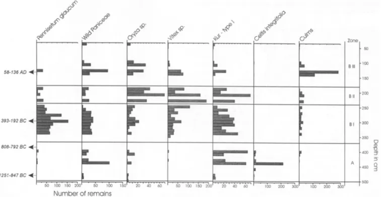
Fig. 5 : Kursakata: Occurrence of the main taxa in absolute numbers through the sequence
5 O ] o 0 B III ' 1 6 0 , 2 0 0 B I} , 2 5 0 B I , 3 0 0 ' 3 5 0 C ] (D 7 9 , 4 0 0 A O ' 4 5 0 5 0 0
type are also very common but less numerous than in the late Stone Age layer. Nearly all remains are carbonised; uncharted ones are very rare. '
Three subgroups can be identified in the Iron Age layer (Fig. 5): subunit BI (370-250 Cm), subunit B2 (250/230- 190 cm) and subunit B3 (190/140 cm to the surface). Do- mesticated pearl millet is dominant in B1 between 370 cm and 250 cm. Hundreds o f spikelets of Pennisetum glaucum have been identified in the organic-tempered pot- sherds o f the levels from 370 cm to 340 cm, for which soil samples are missing (Table 3). In the soil samples from 340 cm to 250 cm, pearl millet reaches high values of up to 70% o f the charred cereal remains (P. glaucum, Paniceae and rice). Paniceae are present with ca. 20% and rice with l 0%. From 240 cm upwards, domesticated P. glaucum de- creases to 10 - 20%, whereas the proportion of rice in- creases (Fig. 5). The amount o f rice and Vitex (some o f it identified as V. simplieifolia) is remarkably high in B2 be- tween 250 cm and 190 cm. In B3, above 200 cm charred culms are dominant (see Results, B, The charcoal se- quence). Paniceae and wild rice are still frequent, whereas pearl millet occurs sporadically in small amounts. The potsherds in the uppermost levels are also tempered with culms.
Results; charcoal Description of the taxa
As most of the taxa found in the samples have already been described in a previous publication (Neumann et al. 1998), only two new charcoal finds are presented. Both taxa are very abundant in the samples: Kigelia africana and Vitex sp. The description follows the IAWA character list (IAWA Committee 1989), modified for DELTA (Richter and Trockenbrodt 1995).
Kigelia africana, Bignoniaceae (Fig. 6a-c)
Growth rings not visible. Vessels solitary and in small ra- dial groups of 2, more rarely in clusters, tangential diam- eter up to 150 pm, often with globular inclusions partly or completely filling the lumen; perforations simple, intervessel pits alternate, 5-7 ~tm in tangential diameter, not vestured, vessel ray pits similar to intervessel pits. Fi- bres thin to medium thick-walled, sometimes with a dis- tinct radial pattern, not septate. Parenchyma confluent to broadly banded, more rarely aliform, in short strands. Rays 1-4 cells wide, less than 500 ~tm high, heterocellular, composed of short procumbent and square/upright cells. No storied structure and no crystals observed.
Diagnostic remark: from the cross section, this wood might be confused with several Leguminosae (Fabaceae). Nevertheless, only few Leguminosae have heterocellular rays, and Kigelia clearly diffe/s from them in its pit struc- ture: in contrast to Leguminosae, the pits o f this wood are not vestured. However, as this character can unequivo- cally only be observed in SEM, separation from Legumi- nosae might be difficult, especially when they appear in the same sample. Therefore, an undifferentiated Legumi- nosae/Bignoniaceae type has been given in the species list.
simple, intervessel pits alternate, ca. 5 im in tangential di- ameter, not vestured, vessel ray pits and vessel paren- chyma pits with reduced borders, distinctly larger than intervessel pits, mostly elongate. Fibres thin to medium walled, sometimes in radial rows, septate. Parenchyma paratracheal scanty, often hardly discernible from thin- walled fibres. Rays up to 5-seriate, heterocellular, com- posed o f short procumbent cells with one marginal row of square/upright cells, or mixed short procumbent and square/upright cells; sheath cells present. No storied struc- ture and no crystals observed.
Diagnostic remark: Vitex sp. can be easily confused with Bridelia (Euphorbiaceae). Both genera contain sev- eral species and are quite variable. Based on pit structure, observed in SEM, distinction is possible. In contrast to Bridelia, the pits o f Vitex are not vestured. At present, wood of Vitex sp. cannot be identified to species level. The charcoal sequence
A total of 1469 charcoal fragments has been identified from 29 levels (490 cm to 190 cm, Fig. 7). In the levels above 190 cm, no identifiable charcoal was found. Com- mon taxa are Mitragyna type, Acacia nilotica, Prosopis @icana, Vitex sp., Ziziphus sp. and Kigelia africana. Mi- nor taxa are Capparis tomentosa, Celtis cf. integrifolia, Securinega/Hymenocardia, Khaya sp., Acacia raddiana type, Balanites aegyptiaca, Acacia albida, Tamarindus sp., Maerua crassifolia and cf. Bauhinieae.
The profile can be d e a r l y divided into a lower unit A (from 490 to 390 cm) and an upper unit B (from 380 to 190 cm). This division corresponds with the fruits and seeds sequence and the archaeological differentiation between the late Stone Age and the Iron Age layers. With regard to the charcoal results, the most distinctive difference be- tween the two units is the presence of Mitragyna type in all samples from A, in contrast to its complete absence in B. Celtis cf. integrifolia and Capparis tomentosa show a similar distribution. The absence of Acacia albida in A and its presence in B cannot be interpreted as significant as the sample size is generally too small in A. Above 190 cm, no charred wood is present, and the "thick bands of charcoal" described by Gronenborn (1998, p 233) consist almost completely o f culms, possibly the remains o f roofs from houses which burnt down several times.
The woody taxa belong to three ecological groups, based on their habitat requirements (after v, Maydell 1983; De Leeuw and Tuley 1972; Aubr6ville 1950). The majority grow in moist to wet habitats, along rivers and streams or temporarily inundated soils. Only Prosopis africana, Balanites aegyptiaea, Maerua crass(folia and Acacia albida, the second group, grow on well-drained sandy soils. A third group consists o f undifferentiated taxa which, due to the low identification level, cannot be attrib- uted to a specific habitat. The Acacia raddiana type con- tains several species growing on sand, such as A. raddiana or A. senegal, and others found in wet places, such as A. seyal. As A. seyal is the most abundant species on thefirki clays today, it seems reasonable to attribute the charcoal to this species.
Discussion Vitex sp., Verbenaceae (Fig. 6d-f)
Growth rings not visible. Vessels solitary and in small ra- dial groups, more rarely in clusters, tangential diameter up to 150 im, often with thin-walled tyloses; perforations
Taphonomy and methodological problems
The assumption of plant use is based on the frequent and abundant occurrence of their diaspores in a subfossil as-
Fig. 6: Kursakata: SEM photographs of charcoal, a) Kigelia @icana, cross section, b) K. @icana, tangential section, c) K. africana, radial section, non-vestured intervessel pits, d) Vitex sp., cross section, e) Vitex sp., tangential section, simple vessel-parenchyma pits and septate fibres, f) Vitex sp., radial section, non-vestured intervessel pits
semblage. We think that all charred remains result from plants which were brought intentionally into the settlement for human use. An exception is probably the ruderal weed
flora, which might have grown either within the settlement or outside it in association with wild cereals, with which they were gathered and thus brought into the village acci-
dentally. Together with the collected wild plants, the weeds represent a part o f the natural composition of the surrounding herbaceous vegetation. Uncharred remains like
Celtis integrifolia
fruit-stones as well as the uncharred taxa (such asFimbristylis hispidula
orBulbostylus
congoIensis)
might originate from the local vegetation of the settlement area. It would be interesting to know whether some of the seeds represent weeds from pearl mil- let fields. Candidates are the taxa which grow on sandy soils. In the absence of a closed assemblage, we cannot reconstruct a real palaeocoenosis (the original combina- tion o f a growing plant community).Our results shed light on the development of the settle- ment and environment of Kursakata. However, as only two square metres have been excavated, the potential for re- presentative hypotheses concerning the whole mound is limited, the location of activities can change in the course of occupation. Therefore, our interpretation of agricultural practices and plant use and their changes through time is preliminary and needs further confirmation by data from comparable sites.
P alaeoethnobotany
1. Domesticated cereals.
Among the identified plantsPennisetum glaucum,
the domesticated form of pearl mil- let, is the only cultigen. This indigenous African cereal, interfertile with wild races, is a free-threshing and self- pollinating diploid crop which can grow under a minimum annual rainfall of 250 mm (Harlan 1989b, Brunken et al1977).
No charred threshing remains of pearl millet besides two involucres, such as bristles or spikelets, have been found. Perhaps the fragile bristles did not survive the
archaeobotanical sieving procedure, but then the more ro- bust parts of the ear should have been found if they had ever come into contact with fire. Our study of remains of modern African pottery, oven fired with pearl millet straw, revealed that ears, bristles, involucres and a few grains were well preserved. Hence it can be expected that these charred parts would also be preserved in fossil assem- blages. In the ceramic impressions from Kursakata, the presence of bristles and involucres indicates that threshing remains o f
Pennisetum glaucum
were used for tempering. The absence o f bristles and spikelets might be due to threshing which may have been done elsewhere in the set- tlement or chaff may not have been burnt.The small size of all pearl millet grains is surprising. They just reach the size of the smallest modern grains of specimens with ears only 4 cm long, as studied in the Her- barium of the Botanical Garden and Botanical Museum at Berlin. Today, even the grains of hybrids between domes- ticated pearl millet and weedy races (called
shibras)
are usually larger than the archaeological specimens. This phenomenon cannot be sufficiently explained by shrinking during the carbonisation process. Hence it seems likely that the subfossil grains represent an early stage o f domes- tication.According to Harlan (1971), pearl millet was probably domesticated in a broad belt at the southern margins of the Sahara. If the domestication area included
thefirki
plains, and if the first domestication phase were represented in Kursakata, we would expect to find a mixture of wild and small domesticated forms. As wildPennisetum
grains can hardly be found in our samples, an introduction of this cultigen from outsidethefirki
area seems most likely.E 0 c Q . I D m o i s t t o w e t h ~ ; ~ + ~
/
J
]ram!
~ r ~ ( ] . , '4'0' ' " - 6 ~ ' ' '2'0' ' '4'0 ' ' 6 ' ~/
3
ON 3E ~TE ) N E 3EAnalysis: K. Neumann & D, Uebel Fig. 7: Kursakata: The claarcoal sequence, absolute numbers os fragments
Archaeobotanical evidence for Pennisetum spp. and its early domestication history is still very scarce. The earli- est finds are reported from Dhar Yichitt in Mauretania, on the southern fringes of the Sahara, where wild and domes- ticated forms have been found as impressions in ceramics (Amblard 1996; Amblard and Pernhs 1989; Jacques-Felix 1971) dated to around 3500 B.P. (1800 cal. B.C.). Domes- ticated P. glaucum has been identified in potsherds from Karkarichinkat in the Lower Yilemsi Valley (Mali) with an uncertain age of probably 3300 B.P. (Smith 1974, 1972). Charred grains of domesticated P. glaucum are present in Tin-Akof and Oursi (Sahel of Burkina Faso), both with a date of around 1000 cal. B.C. (Kahlheber et al. in press; Vogelsang et al. 2000; Neumann 1999a). The earliest im- pressions o f domesticated P. glaucum in potsherds from Gajiganna, 100 km to the west of Kursakata, are dated to 1200-1000 cal. B.C. (Breunig and Neumann 1999; Klee and Zach 1999). As in Kursakata, the grains from Tin- Akof, Oursi and Gajiganna are also rather small.
It remains unclear whether in earlier times wild Pennisetum spp. were widely distributed on the sandy ar- eas around Kursakata. The presence o f wild Sorghum sp. in some levels points to S. aethiopicum stands, which pre- sumably covered thefirki plains as described by De Leeuw et al. (1972). However, there is no evidence for intentional harvesting o f wild Sorghum sp. and thus it seems most likely that the wild ancestors of both indigenous African crops were not collected in thefirki region.
Domesticated Sorghum bicolor has not been found in Kursakata. Preliminary studies at the firki sites Daima (Connah 1981, pp 188 f) and Mege (Klee and Zach 1999, Zach et al. 1996) revealed that it was not introduced into this area before A.D. 800, when the settlement of Kursakata had already been abandoned.
2. CoIlected wild cereals: rice and Paniceae. Wild cereals played a major role as a source o f carbohydrates at Kursakata. Numerous grains of Paniceae and Oryza sp. are present in all levels, but no threshing remains or grains in glumes have been found. Following Wasylikowa (1997), we consider an accumulation 'of one type of grass in an archaeological context as an indication of its purposeful collection. Like pearl millet, wild grasses might have been cleaned and prepared for cooking. A lot of ethnographic information is available on harvesting o f grasses (see Burkill 1985-97). Grains of wild grasses were a major part of the diet up to the 19th century (Harlan 1989a) and are still collected today. In years with sufficient rainfall the grains of wild grasses are only used as food in addition to the staples sorghum and pearl millet. In droughts their availability becomes crucial to survival (Harlan 1989a).
The rice from Kursakata is assumed to be wild because some o f the subfossil grains resemble Oryza longista- minata. However, the identification of rice grains remains problematic, as no reliable features have yet been de- scribed in the taxonomic literature. The Asian rice O. sativa was introduced in the last 500 years (Burkill 1994). Important indigenous rice species are the wild O. barthii and O. longistaminata and the domesticated African rice O. glaberrima. The annual O. barthii frequently grows in shallow, temporarily flooded depressions, whereas the perennial O. longistaminata is restricted to permanent wa-
ter bodies (Harlan 1989a). Today, wild rice is commonly collected by women in thefirki plains and sold at the mar- kets.
Among the numerous remains of Paniceae four genera could be identified. Digitaria, Braehiaria and Echinoch- loa are most abundant and thus regarded as collected cere- als. However, given the current state of taxonomic knowl- edge, identification to species level is not possible. Cenehrus and Eleusine, a member of the tribe Eragrosti- dae, are represented only by scattered finds.
Nevertheless, it is obvious.that Paniceae were a staple food o f the Kursakata people. Today, a mixture of several Paniceae, named either acha, kasha or kreb, are sold at local markets. In the last century, European travellers mentioned the harvesting of kreb in the Lake Chad area (Nachtigal 1881; Barth 1857). Kreb is a mixture with vari- able proportions o f small Paniceae grains including Panicum, Brachiaria and Echinochloa (such as E. py- ramidalis, E. stagnina).
3. Tree fruits. The edible fruits o f the trees Vitex simplicifolia, Celtis integrifolia and Ziziphus mauritiana or Z spina-christi were frequently encountered besides numerous kernel fragments of Vitex sp. and the unidenti- fied fragments of fruit stones. Vitex is the most abundant fruit tree. Today, Vitex simplicifolia grows in Sudanian and Guinean savannas. Its habitat extends to the southern Sahel in areas with a high groundwater table. The fruit pulp is edible and twigs are regularly used as chewsticks (v. Maydell 1983; Irvine 1961). The large number o f c a r - bonised fragments of Vitex sp. in the samples suggests that the kernels were either involved in a roasting process or were thrown as waste into the fire. However, up to now we do not know o f any ethnographic examples of roasting of the kernels.
Many Celtis integrifolia fruit fragments were recov- ered in the lower levels of the late Stone Age. Celtis is a Sudanian tree which also grows extrazonally along rivers and depressions in the Sahel. Since nearly all kernels were uncarbonised, there is no evidence for their use in cooking or any other preparation method using fire. It remains un- clear why they are absent from the Iron Age layer. We can either assume that the fruits, which ripen in the late dry season, were brought in from outside and eaten fresh on the spot, or that a Celtis tree was growing in the settlement. It is also possible that the fruits came in unintentionally with branches cut for their leaves, which were used for human consumption or as animal fodder. Several ethno- graphic examples o f Celtis leaf foraging have been de- scribed by v. Maydell (1983) and Irvine (1961). Charred wood ofC. integr(folia occurs only sporadically in the lev- els around 400 cm.
In contrast to Celtis integrifolia, charcoal remains of Ziziphus mauritiana or Z spina-christi are frequently found, although fruit fragments are rare. Z mauritiana tol- erates great heat and drought and does not require specific soil although not usually growing on clay. Both species can grow on periodically inundated sites and on the edges o f depressions (v. Maydell 1983). The fruits of Z. mauritiana ripen in the dry season and are eaten fresh or dried. In the Sudan, people use the pulp and crush the stones to extract the kernels, which are ground to flour
(Tubiana and Tubiana 1977). Today, both species can be found around Kursakata and in comparison to Celtis, the fruits o f Ziziphus are clearly preferred by the people. It may be that fragments of these fruits are hidden in the bulk of unidentified fruit stone fragments which were found in every level.
One charred seed o f Parkia biglobosa or Acacia nilotica has been found in the 310 cm level. It is likely that it belongs to A. nilotica, the charcoal of which is present throughout the sequence. A. nilotica and P. biglobosa are trees with a large utilisation potential.
The lack of fruit remains of the recently very common species Balanites aegyptiaca is notable. The charcoal finds of B. aegyptiaca indicate that the tree was present in the surroundings. However, the subfossil assemblage of carbonised seeds and fruits only partly represents the spectrum of used plants depending on carbonisation. 4. Other useful plants. Carbonised seeds o f Hibiscus esculentus (ochra) regularly occur in low numbers in the levels between 290 and 340 cm. Ochra is commonly used today and was cultivated in Egypt at 2000 B.C. (Burkill 1985-1997). The unripe fruits are used for sauce or soup. In northeast Nigeria, the seeds are prepared into food and the roasted seeds are used as a substitute for coffee. It is perhaps a cultigen derived from a selection o f / / . ficulneus (Burkill 1997). H. esculentus also grows on fallow land or at the edges o f fields where the so called "wild" fruits are gathered.
One Cyperus sp. rhizome has been found which could not been identified to species level. It closely resembles one of the Cyperus species used for nutrition or for its aro- matic properties such as C. esculentus or C. rotundus. 5. Culms. Fragments of grass culms have been found in almost every level from 430 cm upwards. The bulk o f c a r - bonised remains in the upper levels above 140 cm consists of culms. Potsherds are heavily tempered with this mate- rial. Besides two involucres o f Pennisetum glaucum nei- ther any threshing material from cereals nor processing remains from gathered wild Paniceae and rice were found, so it has to be assumed that food processing is not the rea- son for the frequent occurrence of the culms. One explana- tion, supported by ethnographic analogy in the surround- ing o f Kursakata today, is the use o f straw o f wild Pennisetum spp. and other grasses for roofing. There is also archaeological evidence in the culm-rich levels o f houses which probably burnt down several times (Gronenborn 1998).
Ecological considerations
The recorded herbaceous plants can be classified accord- ing to their ecological requirements as demonstrated by their actual habitats. Dry, sandy soils are the usual habitat of wild and domesticated Pennisetum species, Cenchrus biJlorus, Dactyloctenium aegyptium, Heliotropium cf. subulatum, the latter three on fallow land and pastures - and Trianthema pentandra. On the temporarily inundated floodplains Echinochloa pyramidalis, E. colona, Oryza barthii, O. longistaminata and Sorghum aethiopicum grow. Weeds on cultivated land, on disturbed places or
fallow land are Commelina spp., Eleusine indica, Era- grostis cf. pilosa, Hibiscus trionum and Gynandropsis gynandra (Burkill 1985-1997).
The woody vegetation and its use
In the charcoal diagram, the large number of woody taxa belonging to moist or wet habitats is remarkable. Some of them are also represented by fruits, such as Vitex, Ziziphus and Celtis. This clearly reflects an environment dominated by water as is typical of the Chad lagoonal complex with itsfirki clay soils. Although Kursakata is situated on sand o n the Ngelewa beach ridge, the occurrence of sandy soils is restricted. This is reflected by the low number of fossil taxa, which grow on well-drained soils. In comparison with a settlement mound in a dune area o f Burkina Faso, where 30 woody plants have been recorded (Neumann et al. 1998), only 15 taxa were found at Kursakata. This points to peculiar environmental conditions where only specially adapted plants can flourish.
Only a smaller part o f the firewood was collected on the well-drained sandy soils of the Ngelewa beach ridge in the immediate vicinity o f the settlement (Prosopis africana, Acacia albida, Maerua crassifolia and Balan- ites aegyptiaca). This can partly be explained by the lim- ited extent of the ridge itself. However, the scarcity o f woody vegetation on the dunes in general seems to be a more reliable explanation. With the exception of a few fragments of Bauhinieae (a wood type including Pilio- stigma spp.), no plants o f fallow land - such as Combre- turn glutinosum and Guiera senegalensis - have been found. This could indicate either that there were no fields and fallow land in the area, or that millet was planted on permanent fields and not in a shifting cultivation system. Perhaps most woody plants in the immediate vicinity of the settlement were removed and only a few remained, possibly protected or even cultivated.
If we compare the modern, almost treeless firki with the woody vegetation reconstructed for the period between 1000 B.C. and A.D. 100 at Kursakata, the differences are considerable. Even during the early Iron Age, when the climate was supposedly drier than before, the vegetation was much richer than today and included Sudanian ele- ments like Vitex, Kigelia africana and Khaya. Today the firki at first sight seem to be a hostile environment for woody plants because o f their clay soils which are usually regarded as unfavourable for tree growth. However, there are distinct variations in soil patterns (Thiemeyer 1997, pp 66 ff; Kirscht and Skorupinski 1996; Sturm eta[. 1996; De Leeuw and Tuley 1972, p 114) which might have resulted in a mosaic-like distribution of woody formations and grasslands in the past. Several woody communities prob- ably existed especially onfirki soils with higher sand con- tents, called motusku (Kirscht and Skorupinski 1996) and in those places where the underlying Pleistocene dunes are lying near to the surface (see De Leeuw and Tuley 1972, p 114). Comparable modern communities have been de- scribed by De Leeuw and Tuley (1972, pp 151 ff) as "riparian woodland" with Mitragyna inermis, Acacia nilotica, Kigelia africana, Celtis integrifolia, Khaya senegalensis, Vitex simplicifolia and several Acacia spe- cies, but these are only found outside the Chad lagoonal
complex. In the Chadian part of the Chad basin several of the taxa mentioned above occur either along rivers and streams or in depressions with temporarily inundated soils (Pias 1970, pp 20 ff.). However, Acacia seyal is dominant in the modern dense woody formations on clay soils (Grondard 1964, p 26), whereas Kigelia africana, Celtis integrifolia, Khaya senegalensis and Vitex simplicifolia only grow further south under higher rainfall. The woody plant communities on thefirki in Cameroon are also domi- nated by Acacia seyal, with occasional admixtures o f other species (Letouzey (1968, p 32l).
Although dense woody formations existed in the firki around Kursakata, there are indications that their distribu- tion was limited. Two o f the dominant taxa, Vitex sp. (v. Maydell 1983, but see Irvine 1961 for the opposite view) and Kigelia africana (Irvine 1961), are known for their inferior quality as firewood. Probably for this reason, wood of Vitex sp. is missing from archaeological sites o f Burkina Faso (Neumann et al. 1998) whereas its fruit re- mains are generally well represented. As the inhabitants o f Kursakata collected most of their firewood from these spe- cies, it can be suggested that not enough high-quality fuel was available. This hypothesis is supported by the com- paratively uniform distribution o f the woody taxa in the charcoal samples, indicating a non-selective collecting be- haviour typical o f people living in an environment with limited fuel resources (Neumann 1999b).
Today, the species-rich woody formations have com- pletely vanished from thefirki region of northeast Nigeria. It is remarkable that the Acacia raddiana charcoal type, which probably represents A. seyal, is rare in the samples whereas this species is dominant today in the remaining woodlands on thefirki. For the impoverishment of the veg- etation through time, several hypotheses can be formu- lated: first, the tree cover ofthefirki was largely destroyed when sorghum cultivation started on the clay soils in medi- eval times, since the farmers preferred those soils for culti- vation which are also favourable for tree growth. Sec- ondly, the Sudanian taxa were eliminated from the woody communities as a consequence of increasing aridification. Thirdly, rich woody communities persisted up to historical times and were only cleared during the last decades in the frame of the "South Chad irrigation project" for large- scale irrigated cereal production. For testing these hypoth- eses, additional archaeobotanical data from other sites in thefirki would be needed.
Palaeoenvironment and economy
1. The late Stone Age. In comparison with the early and middle Holocene, the climate from 1000 B.C. onwards, when the firki plains became accessible, was relatively dry. However, the environment o f Kursakata during the first settlement phase (the late Stone Age from ca. 1000 to 800 B.C.) was still characterised by water. The charcoal analysis shows that some trees from wet habitats were growing in the surroundings, possibly including Mitragyna inermis in depressions inundated for several months o f the year.
According to Gronenborn (1998) the settlement was located close to a large lagoon. The assumption that the site was only seasonally occupied (Gronenborn et al.
1996) is supported by the small amount of botanical re- mains, indicating scarce settlement activities in the late Stone Age. The few finds of pearl millet and the much greater number o f gathered wild cereals and fruits support the hypothesis of a seasonal occupation without agricul- tural activities in the area. Maybe the site was only used in the dry season, when water levels were low. The perma- nent water fish Lates which is present in the faunal remains (Gronenborn 1998), was caught in addition to fish from shallow muddy flood plains and from marshy, vegetated areas (W. van Neer, personal communication). Cattle grazed along the edges of the numerous ponds on thefirki plains. From the available organic remains, Connah (1981, p 98) concluded that "... the subsistence economy of the Kursakata villagers was probably based on mixed farming and some hunting and fishing". Now, as more archaeobo- tanical, archaeological and archaeozoological data are available, we conclude that the economy was more diver- sified, and agriculture only played a minor role, in addi- tion to cattle-raising, fishing and the collection o f wild grasses.
2. Climati c change and the end of the late Stone Age. The abrupt change in the distribution of the Mitragyna type present in all charcoal samples from the late Stone Age layer (unit A, 490-390 cm) and completely absent from the Iron Age (unit B, 380-190 cm), is remarkable. Mitragyna is a wood type of the family Rubiaceae comprising several species and so far imperfectly defined (Neumann et al. 1998). From its phytogeographic distribution and ecologi- cal requirements, it can be assumed that the Mitragyna type o f Kursakata belongs to M. inermis, a Sahelo- Sudanian tree commonly found in depressions with clay soils inundated for several months of the year. M. inermis provides excellent firewood (v. Maydell 1983). Therefore its absence from the Iron Age should not be related to changes in selective collecting o f firewood, but rather to a decline in species abundance after 2600 B.P.
Even though the Mitragyna type is present at other set- tlement mounds ofthefirki up to modern times - such as in Mege, where itwas found in a level dated to 365--66 uncal. B.P., and in Ngala dated to 1165• uncal. B.P., respec- tively - its complete disappearance at Kursakata points to a sudden onset of drier conditions resulting in the desicca- tion of the seasonal ponds around the site. The two species Capparis tomentosa and Celtis integrifolia - both of which grow in moist habitats - show a similar trend in the char- coal sequence as the Mitragyna type and hence furnish additional evidence for an aridification.
Detailed stratified palaeoclimatic indicators from the Sahel and the Chad Basin for the third millennium B.P. (= the first millennium B.C.) are scarce. There are indica- tions that the late Stone Age cultures o f the Sahel wit- nessed a major crisis during this period. Both in thefirki and in the Gajiganna region to the west, an abrupt hiatus in settlement activities can be recorded between 800 and 600 cal. B.C. A similar trend is evidenced from the Sahel of Burkina Faso, where for the first millennium B.C. almost no traces o f settlement activities are recorded (Breunig and Neumann 1999). The disappearance of the Mitragyna type at Kursakata coincides with changes in the archaeobotanicM sequence, sedimentology, archaeozoolo-
gical finds and artefacts (Gronenborn 1998), suggesting a close relation between aridification and the end of the late Stone Age culture.
The most recent find o f Mitragyna type at the site is dated to 2 6 t 5 • uncaI. B.P,, 808-792 cat. B.C. (UTC- 5453). Even though comparison of palaeoecological data on a super-regional scale can be misleading if local site conditions are ignored (see Salzmann and Waller 1998), the correspondence with a global phenomenon noted by Van Geel et al. (1998) is remarkable. The authors describe a change towards moister, cooler conditions in Europe around 2650 B.P. (800 cal. B.C.) resulting from reduced solar activity. For tropical Africa a contemporary shift to aridity is suggested which has been supported by re-dating of the pollen profile from Lac Ossa in Cameroon. How- ever, in the pollen diagrams and other palaeoecological data sets from northeast Nigeria, the major change towards aridification is visible between 3800 and 3000 B.P. and not around 2650 B.P. (Holmes et al. 1999; Salzmann and Waller 1998; Salzmann 2000). Further archaeobotanical sequences and other palaeoecological data from the Chad Basin are needed to strengthen or weaken the hypothesis that environmental change in the first millennium B.C. was contemporary with and related to global climatic events. 3. The 1ton Age. Our archaeobotanical investigations have shown that the transition from late Stone Age to the Iron Age (between 800 and 400 cal B.C.) was accompanied by the beginning o f large-scale farming. Changes in the plant spectra are contemporary with .changes in the archaeologi- cal sequence (Gronenborn 1998). The site may have been permanently occupied. Since the frequencies o f pearl mil- let are significantly higher than before, it seems most likely that this crop was cultivated on the sandy soils close to the site. However, collection o f Paniceae and wild rice was still of great importance.
Cultivation of pearl millet and permanent occupation were presumably possible as a consequence o f environ- mental change towards drier conditions. With decreasing inundation frequencies, larger sandy areas might have be- came more open and suitable for arable farming. Large amounts of carbonised pearl millet grains were found es- pecially in the oldest levels of the Iron Age, indicating its cultivation on sandy soils near the settlement. The devel- opment o f agriculture was probably also promoted by technical innovations at the onset o f the Iron Age.
In the upper Iron Age levels (above 250 cm), pearl mil- let is only present in small amounts, but wild plants are still recorded. Rice and Vitex sp. become more frequent and may imply a greater economic importance than before. We cannot say whether agriculture lost its importance or whether processing of pearl millet was done in another part of the settlement. However, from the archaeological evidence (Gronenborn ] 998), it seems more likely that the shifting o f activity zones is responsible for the change in the archaeobotanical spectrum, at least from 190 cm up- wards.
Conclusion
The availability of rich natural resources especially in the dry season seems to have been an important reason for the first inhabitants o f Kursakata to settle near temporary or
permanent ponds in spite of the risk that their settlement would become inundated during the rainy season. The rich stands o f wild grasses like rice and Paniceae in the season- ally flooded depressions and thefirki plain were probably an important factor, not only for human nutrition but also for livestock grazing during the dry season, when the pas- tures on the sandy soils were desiccated.
The results clearly show that cultivated pearl millet was known from the beginning of the occupation, though there are only a few grains in the lowest late Stone Age levels. Early agriculture in the Chad Basin has also been confirmed by the archaeobotanical data fronl the Gajiganna region 100 km west o f Kursakata (Breunig and Neumann 1999; Klee and Zach 1999). In both areas there are indications that agriculture and the knowledge of plant domestication were introduced from outside. In Gajiganna this introduction has been dated to 1200 cal. B.C., in Kursakata around 1000 cal. B.C.
However, it seems that agriculture played a minor role in the late Stone Age, when the site was presumably occu- pied only during the dry months and activities consisted mainly o f fishing, cattle grazing and collection of wild ce- reals. With the onset of the Iron Age, agriculture gained more importance. This economic change coincided with a permanent occupation o f Kursakata, the introduction o f iron technology, and a shift to more arid conditions.
A most remarkable feature of the late Stone Age as well as o f the Iron Age economies is their great diversity. The exploitation o f a wide spectrum o f natural resources was a way ofminimising the risk o f failure. In an area with unpredictable rainfall Iike the Chad Basin, a mixture of farming and gathering o f wild cereals could guarantee a permanent supply of carbohydrates. Therefore the wild grasses, mainly rice and Paniceae, should not only be re- garded as additional or famine food, but as a permanent factor in a very flexible, highly adapted subsistence strat- egy which also included fishing and the keeping o f cattle and small livestock.
In comparison with Europe and the Near East, wild grasses play a much more important role in the economies which developed in the African savanna regions. This fea- ture can be observed from the late Stone Age through to modern times and is even reported from medieval urban centres like Great Zimbabwe (Jonsson 1998) or Jennd- Jeno/Mali (McIntosh 1995). Our results show that in the Chad Basin with its rich grass communities, harvesting o f wild rice and Paniceae can be traced back to the beginning o f the late Holocene occupation which started around 1000 B.C. in Kursakata. Thus, the archaeobotanical data attest to a successful tradition which continued for almost
1000 years.
Acknowledgements. We wish to express our indebtedness to everyone who has made this project possibJe: Peter Breunig and DetlefGronenborn, who excavated the site, and Wire van Neer, who undertook the archaeozoologicaI part. Our sincere thanks also to Krystyna Wasylikowa, who studied the Paniceae with us for some days in the Frankfurt Laboratory; to Manfred B~issler of the Herbarium of the Botanischer Garten und Botanisches Museum Berlin Dahlem (B), who patiently helped us through the Herbarium and offered us assistance in whatever way we re- quired and also to Claude Farron of the seed collection of Basel; to Du~anka Kucan in WilheImshaven and Urs Weber in Basel