1
Centering Peripheries: Warning Systems and Disaster Risk Reduction
Planning on the Island City
By Lily D. Bui
B.A., International Studies University of California Irvine (2009) B.A., Spanish, University of California Irvine (2009)
M.S., Comparative Media Studies, Massachusetts Institute of Technology (2016)
Submitted to the Department of Urban Studies and Planning in partial fulfillment of the requirements for the degree of
Doctor of Philosophy in Urban and Regional Planning at the
MASSACHUSETTS INSTITUTE OF TECHNOLOGY
February 2020
© 2020 Lily Bui All Rights Reserved
The author here by grants to MIT the permission to reproduce and to distribute publicly paper and electronic copies of the thesis document in whole or in part in any medium now known or
hereafter created.
Author_________________________________________________________________
Lily Bui Department of Urban Studies and Planning
December 16, 2019 Certified by _____________________________________________________________
Professor James Wescoat Department of Urban Studies and Planning Dissertation Supervisor Accepted by______________________________________________________________
Professor Jinhua Zhao Chair, PhD Committee Department of Urban Studies and Planning
2
Centering Peripheries: Warning Systems and Disaster Risk Reduction Planning on the Island City
By Lily D. Bui
Submitted to the Department of Urban Studies and Planning on December 16 in Partial Fulfillment of the Requirements for the Degree of Doctor of Philosophy in Urban and Regional
Planning
ABSTRACT
Warning systems play a crucial role in disaster events on islands. They enable timely communication of risk, bolstering capacity and counterbalancing the negative force exerted by hazards, exposures, and vulnerabilities that threaten island communities. Disasters frequently result in the breakdown of communication due to both structural (i.e., power outages, failed telecommunications equipment, aging infrastructure) and nonstructural issues (i.e., governance, socioeconomic inequity, language barriers). Through semi-structured interviews, participant observation, document review and spatial data visualization, this dissertation compares the hurricane warning systems of two U.S. island cities: San Juan, Puerto Rico, and Honolulu, O’ahu, Hawaii, during Hurricane Maria (2017) and Hurricane Lane (2018), respectively. The research questions are as follows:
❖ Under what conditions are warning systems successful or unsuccessful in island cities? ❖ What gaps in capacity can be observed in island city warning systems?
❖ How do these gaps affect disaster planning in the island context?
This dissertation proposes a conceptual framework for evaluating warning systems that takes into consideration the temporal aspects of warning. The framework illustrates the ways in which warning and planning are interrelated, as well as how planning and warning processes take place over time. The dissertation argues that good planning is good warning, and good warning is shaped by good planning. It finds that short-term warning (i.e. forecasting) is usually able to achieve its goals successfully whereas long-term warning (i.e. planning around
preparedness, generational knowledge and culture, myths and history, and recovery) is prone to various capacity gaps across the two cases. The most significant finding is that O’ahu and Puerto Rico’s planning and warning capacity grew after Hurricanes Lane and Maria, but the gap in capacity between both islands still remains noteworthy. Ultimately, the planning gaps between both islands point toward other possible differential capacities for planning and warning on other U.S. islands.
Dissertation supervisor: James Wescoat
3
Invite your ancestors into the conversation. What would they have said?
Invite your grandchildren into the conversation. What are their needs?
As we plan ahead for disasters, invite your heart into the conversation.
Do the good work. Others' lives depend on it.
4
Table of Contents
Abstract 2 List of Figures 6 Acknowledgements 9 Part IChapter 1 - Warnings: An Existential Island Dilemma 10
1.1 Urban islands, disaster risk reduction, warning systems, and planning 13
1.1.1 The urban island context 13
1.1.2 How warning systems connect risk and resilience 19
1.1.3 Warning systems as capacity 21
1.1.4 The role of planning in disaster risk reduction on islands 24 1.1.5 Disaster planning on islands cities versus continental cities 27
1.1.6 Intellectual contribution 31
1.2 Research Questions & Hypotheses 34
1.3 Case Selection: Oahu and Puerto Rico 35
1.3.1 Hurricane Maria and Hurricane Lane 46
1.3.2 Key similarities and differences between Puerto Rico and Oahu 41
1.4 Methodology and Data Collection 44
1.4.1 Primary methods 45
1.4.2 Secondary methods 48
1.4 Limitations and Reflections 49
1.6 Dissertation Structure 50
Chapter 2 - What Does it Mean to Be Warned? 52
2.1 The United States National Weather Service and its Presence on Islands 54
2.2 What Does it Mean to Be Warned? 59
2.3 Anatomy of a Warning System 67
2.3.1 Structural and Nonstructural Components of Warning Systems 71
2.3.2 Formal and Informal Warning Messages 74
2.4 Warning and Planning as Dimensions of Capacity in Island Communities 76 2.4.1 Spatial and social factors related to effectiveness of
island warning systems 78
2.4.2 Inter-island factors 78
2.4.3 Intra-island factors 79
2.4.4 Cross-cutting factors 80
2.5 An Analytical Framework for Warning Systems 83
2.6 Method of Analysis 86
2.6.1 Coding the data 86
2.7 Conclusions 88
Part II
Chapter 3 - Forecasting: Where Science and Expertise Take
Center Stage to Bring Knowledge Into Action 90
5
3.2 Forecasting During Hurricanes Maria and Lane 96
3.2.1 Environment & Detection 96
3.2.2 Management and Coordination 100
3.2.3 Formal and informal warning messaging 105
3.2.3.1 Rumors and rumor control during disasters 116 3.3 Summary of Planning Successes and Gaps for Short-Term Warning in
Puerto Rico & O’ahu 117
3.4 Conclusions 120
Chapter 4 - Rethinking the Relationship Between Warning and
Planning in Puerto Rico & O’ahu 122
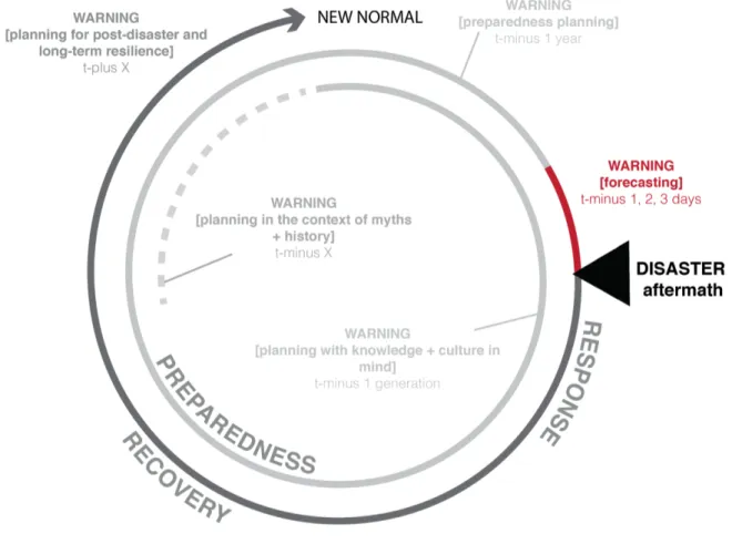
4.1 The Aftermath (Response) 127
4.1.1 Puerto Rico 127
4.1.2 O’ahu 130
4.2 T-minus 1 year: Preparedness Planning 131
4.2.1 Past plans 131
4.2.2 Pre-disaster preparedness education and training 140
4.2.3 Prior experience with disaster 145
4.2.4 Planning implications 148
4.3 T-minus 1 generation: Planning with Knowledge and Culture in Mind 148
4.3.1 Planning implications 152
4.4 T-minus X years: Planning in the Context of Myths and History 153
4.4.1 Planning implications 159
4.5 T-plus X years: Planning for Post-Disaster and Long-Term Resilience 161
4.5.1 Recovery planning 162
4.5.2 Community-led recovery & resilience initiatives 164
4.5.3 Education and training 169
4.5.4 Problems of inertia and inequity in recovery 174
4.5.5 Planning implications 178
4.6 Summary and Conclusions of Planning Successes and Gaps for Long-Term
Warning in Puerto Rico & O’ahu 180
Part III
Chapter 5 - From Noise to Signal: Rewiring Island Warning Systems 185 5.1 Findings, conclusions, and comparisons for case studies 186
5.2 Planning recommendations 195
5.3 Intellectual contributions and future directions 201
5.4 Terra Cognita 203
References 205
6
List of Tables & Figures
Chapter 1Fig. 1-1. Map for the Game of Risk, 11
Fig. 1-2A. (left) Island of Atlantis, 12
Fig. 1-2B. (right) Island of Utopia, 12 Fig. 1-3. Islands around the world, 14
Fig. 1-4. Disaster risk and resilience, and their relationship with hazards, exposure, vulnerability, and capacity, 20
Fig. 1-5. Scales of planning capacity, 22
Fig. 1-6. Disaster risk reduction in the planning paradigm versus the hazards and vulnerability paradigms, 26
Fig. 1-7. Rockefeller Resilient Cities Network, 29
Fig. 1-8. Comparison of key planning assumptions and field reports in Texas and Florida, 30
Fig. 1-9. Comparison of key planning assumptions and 2017 Hurricane Impacts in Puerto Rico, 31
Fig. 1-10. The relationship between planning and warning, 32
Fig. 1-11. Framework for analysis planning’s role in warning systems, 33
Fig. 1-12. Two-case comparison between Oahu and Puerto Rico, 36
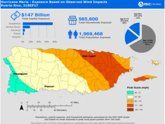
Fig. 1-13. Hurricane Maria track and satellite image, 37
Fig. 1-14. Hurricane Maria wind impacts on Puerto Rico, 38
Fig. 1-15. Hurricane Maria estimated rainfall, 38
Fig. 1-16A. Hurricane Lane track, 39
Fig. 1-16B. Satellite image of Hurricane Lane, 39
Fig. 1-17. 72-hour rainfall totals from Hurricane Lane, 40
Fig. 1-18. Hurricane Lane spaghetti model for possible storm tracks, 40
Table 1-1. U.S. island territories, trust territories, and populations for their “urban” centers, 16
Table 1-2. Comparison between San Juan, Puerto Rico and Honolulu, Hawaii, 42
Table 1-3. Summary of methods, evidence type, and research questions addressed, 45
Table 1-4. Sampling of interview questions that address specific research questions, 46
Table 1-5. Data sets for data visualization, 49
Chapter 2
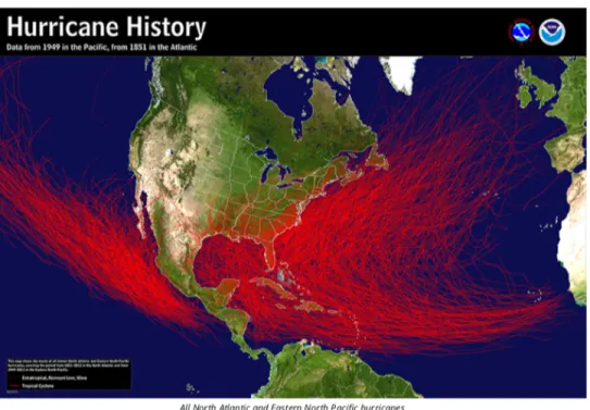
Fig. 2-1. Cyclone tracks from the Sahara to the Caribbean and Pacific from 1949 to present (Pacific) and 1851 to present (Atlantic), 53
Fig. 2-2. Geographical distribution of NOAA’s Doppler Radars, 56
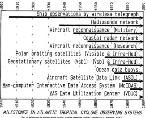
Fig. 2-3. Technological milestones in Atlantic Tropical Cyclone Observing Systems, 57
Fig. 2-4. Actors involved with forecasting versus warning, 62
Fig. 2-5. NWS impacts-based reporting model for hurricanes, 65
Fig. 2-6. Classical model of communication, 67
Fig. 2-7. Mileti & Sorenson (1990) warning communication model, 68
Fig 2-8. Annotated framework for characterizing and evaluating warning systems, 69
Fig. 2-9. Structural and nonstructural components of warning systems, 71
Fig. 2-10. Evacuation zone sign in Puerto Rico, 72
Fig 2-11. PrepHub, infrastructural design intervention meant to serve as a reminder to communities of available resources during disaster, 73
7
Fig 2-11. Island X, 83
Fig. 2-12. Proposed analytical framework for evaluating warning systems, 84
Table 2-1. History of National Weather Service Offices on U.S. Islands, 57
Table 2-2. Definitions of warning systems, 67
Table 2-3. Structural and nonstructural components of warning systems, 74
Table 2-4. Formal and informal warning systems, 76
Table 2-5. Planning constraints relevant to island warning systems, 81
Table 2-6. Coding categories for short-term warnings, 86
Table 2-7. Coding categories for long-term warning, 88
Chapter 3
Fig. 3-1. Forecasting in relation to other forms of warning, 93
Fig. 3-2. Planning “triad” of forecasting, 94
Fig. 3-3a and 3-3b. Development patterns (building footprints) across O’ahu and Puerto Rico, 96
Fig. 3-4a and 3-4b. Electrical grid coverage across O’ahu and Puerto Rico, 97
Fig. 3-5a and 3-5b. Cell phone tower distribution across O’ahu and Puerto Rico, displaying AT&T, Verizon, T-Mobile, and Sprint towers, 98
Fig. 3-6a Cell phone coverage across O’ahu, 98 Fig. 3-6b. Cell phone coverage across Puerto Rico, 98
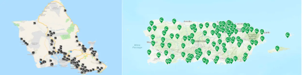
Fig. 3-7a. Evacuation shelters in O’ahu, 99
Fig. 3-7b. Evacuation shelters in Puerto Rico, 10999
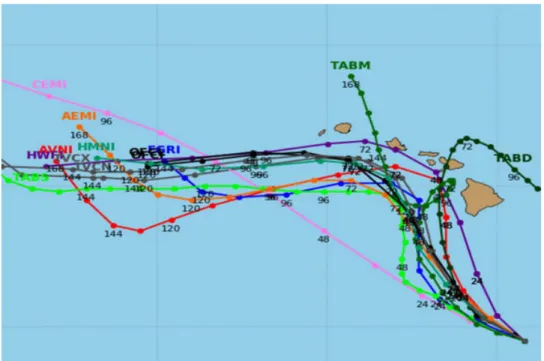
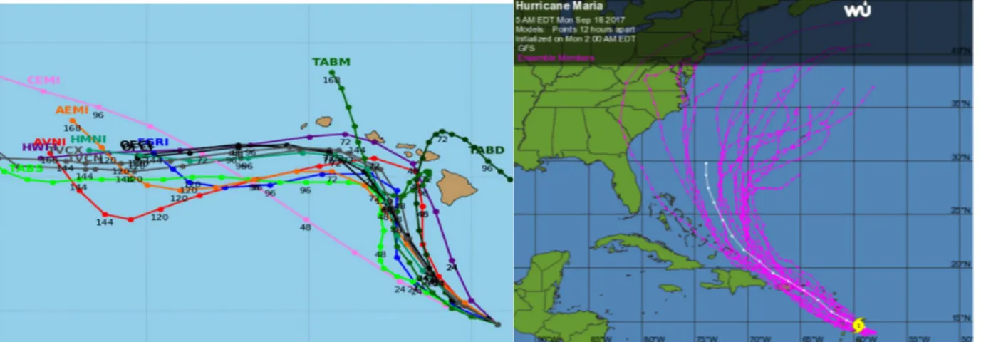
Fig. 3-8a. Spaghetti model for possible Hurricane Lane tracks, 100
Fig. 3-8b. Spaghetti model for possible Hurricane Maria tracks, 100
Fig. 3-9a. Storm surge map for Honolulu, O’ahu, 101
Fig. 3-9b. Storm surge map for San Juan, Puerto Rico, 101
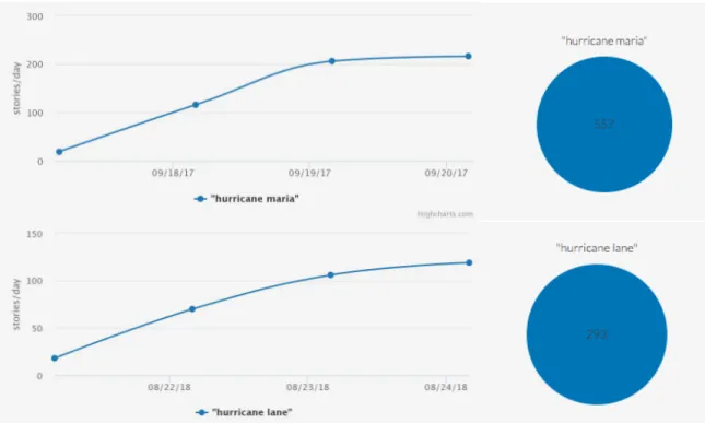
Fig. 3-10a. Media attention for Hurricane Maria from September 17, 2017 to September 20, 2017, 106 Fig. 3-10b. Media attention for Hurricane Lane from August 21, 2018 to August 24, 2017, 106
Fig. 3-11. Public alert for Hurricane Lane watch from National Weather Service, through the Wireless Emergency Alert system, 107
Fig. 3-12. Local news broadcast about Hurricane Lane watch, 107 Fig. 3-13. National news coverage about Hurricane Lane watch, 108
Fig. 3-14. Author during Hawaii Public Radio broadcast two days before Hurricane Lane reached the Hawaiian islands in August 2018, 109
Fig. 3-15. Types of social capital, 110
Fig. 3-16. Tweet from the National Weather Service San Juan, 112
Fig. 3-17. Social media insights report from the National Weather Honolulu, 113 Fig. 3-18. Social media post warning about Hurricane Lane threat, 114
Fig. 3-19. Social media post from Ada Monzón urging people in Puerto Rico to move to a safe place, 115 Fig. 3-20. Ada Monzón’s “coffee and cookie” code for hurricane watches, 117
Table 3-1. Summary of interviewees for Chapter 3, 91
Chapter 4
8
Fig. 4-2. The Whole Community approach involves actors from various sectors, 126
Fig. 4-3. Community Preparedness Groups on O’ahu, 132
Fig. 4-4. Resilient O’ahu initial stakeholder engagement meeting to identify acute shocks and chronic stressors, June 2016, 135
Fig. 4-5. Community feedback cards from Resilient O’ahu initial stakeholder engagement, June 2016, 135
Fig. 4-6. Route 83 in Hau’ula area, 137
Fig. 4-7. Hau’ula Warning Systems & Evacuation objectives and action items, 139
Fig. 4-8. Hau’ula preparedness planning highlighted in community newspaper, 2012, 140
Fig. 4-9. Total NDPTC trainings in U.S. islands (2013-2017), 143
Fig. 4-10. Agenda for consortium on the 2017 Atlantic Hurricane Season in Honolulu, Hawai’i, 146
Fig. 4-11. Infrared satellite images from geostationary satellites showing all 15 tropical storms to reach or form in the Central Pacific basin in 2015, 146
Fig. 4-12. Screenshot of false alarm warning message about ballistic missile threat in Hawai’i, 147
Fig. 4-13. Urbanized areas in Puerto Rico, 151
Fig. 4-14. The Taíno god Juracán, from which the word “hurricane” is derived, 156
Fig. 4-15. Artist’s rendering of the destruction and mayhem visited on a Hawaiian compound during the Hawai’i hurricane of 1871, 158
Fig. 4-16. Map showing the track of the hurricane across the eastern islands of Hawaii and Mau’i on August 9, 1871, 158
Fig 4-17. Tsunami stone in Japan, warning of past hazards, 162
Fig 4-18. Ruth “Tata” Santiago leading a community meeting in the Coqui Community Center in Salinas, Puerto Rico, 167
Fig. 4-19. View of Coqui Community Center from the outside, 167
Fig. 4-20. View of Community Transformation Center in Playita, San Juan, Puerto Rico, 167
Fig. 4-21. Census map of Playita neighborhood in the Community Transformation Center, 168 Fig. 4-22. Hurricane Awareness Tour promotional poster, 170
Fig. 4-23. Map of exhibits in the EcoExploratorio Museum, many of which focus on the island theme, 172
Fig. 4-24. Puerto Rican students visit the EcoExploratorio, 173
Fig. 4-25. National Disaster Preparedness Training Center AWR-356 Community Planning for Disaster Recovery course delivery in San Juan, PR, in June 2017, 174
Fig. 4-26. Local Hazard Mitigation Plan Status as of December 2018, 177
Fig. 4-27. Time compression after disasters, 179
Table 4-1. Disaster plans in place when Hurricanes Maria and Lane arrived, 143
Table 4-2. NDPTC Trainings in Hawai’i and Puerto Rico (2013 to 2017). Source: National Disaster Preparedness Training Center, 156
Chapter 5
Fig. 5-1. The relationship between planning and warning, 185
Fig. 5-2. Planning capacity changes and gaps in Puerto Rico and O’ahu, 194
9
Acknowledgements
My doctoral experience at MIT has been nothing less than transformative. I attribute this completely to the individuals listed here. Foremost, I am grateful to my dissertation committee: Professor James Wescoat, Professor Lawrence Vale, Professor Miho Mazereeuw, and Professor Sarah Williams. They have guided the conceptual and methodological direction of this project, and I simply could not have done this without their subject matter expertise, close reading, real-world perspective, and mentorship.
To my Puerto Rico family, this work is especially for you. It is one of the first of many steps I hope to take in order to stay engaged with disaster risk reduction planning on the island. I owe special thanks to Ada Monzón, Ernesto Morales, Deepak Lamba-Nieves, David
Carrasquillo, Ruth Santiago, Ernesto Diaz, and Clay Bird for the continued conversations we have had throughout the years. I also am incredibly grateful for Professor Maritza Barreto, Ruperto “Chapa” Chaparro, Lillian Ramirez, and Marla Perez Lugo at University of Puerto Rico. Your collective friendship means the world to me, and I am in awe of your leadership.
To my Hawai’i ‘ohana, thank you for helping me find my true north as a scholar. I am inspired to continue working in the realm of island resilience because of the exemplary work you do and have invited me to be a part of. At the National Disaster Preparedness Training Center and University of Hawai’i-Mānoa, I am deeply grateful for the mentorship and friendship of Professor Karl Kim, Roberto Porro, Jiwnath Ghimire, Pradip Pant, Eric Yamashita, Adam Stein, Kalani Souza, Doc Tusi, Dolores Foley, and Gingerlei Porter. At the Michaels Organization, I am grateful for the support of Brandon Hegland, Tharon LeBlanc, Anni Peterson, and Kimberlee Schreiber. Thank you to Josh Stanbro, Justin Gruenstein, and Matt Gonser at the City & County of Honolulu for helping me make valuable connections that I still cherish to this day.
To my Scholars from Underrepresented Groups in Engineering and Social Sciences (SURGE) family, I have learned from you to look across disciplines and to value diversity while pursuing academic research. I have also learned to laugh, to find lightness, and to grow as a leader throughout the PhD experience. My deepest thanks to Dr. Lori Peek, Dr. DeeDee Bennett, Dr. Terri Norton, Dr. Hans-Louis Charles, Dr. Nnenia Campbell, and Dr. Jenniffer Santos-Hernandez for your leadership -- along with the twenty other scholars I had the privilege to meet through this fellowship.
To my family at the U.S. Naval War College Humanitarian Response Program, Harvard Humanitarian Initiative, and Lincoln Laboratory, thank you for giving me space to apply my research and for supporting my professional and personal growth throughout this experience.
Last but absolutely not least, I owe the greatest thanks to my close friends and family, to whom this is work dedicated. My parents Liem and Mai Bui arrived in this country more than three decades ago in search of a better life for themselves and their future children. My
grandparents instilled in both of them values that have driven me: service to others, hard work, and kindness. In the spirit of this dissertation’s thematic focus on time in relationship to planning and resilience, I am reminded of Neil Postman, who once wrote, “Children are the living
messages we send to a time we will not see.” I can only hope to have made them -- as well as my mentors mentioned above -- proud to have sent me.
10
Chapter 1
Warnings: An Existential Island Dilemma
Chapter overview:● Introduces a literature review that ties together warning systems, planning, disaster risk reduction, and island studies.
● Introduces the central research questions, hypotheses, and methods. ● Discusses the limitations of the study.
● Outlines the structure of the dissertation.
New Zealand is disappearing off of world maps.
In a humorous video1 produced by New Zealand Tourism, actor Rhys Darby calls upon
New Zealand’s Prime Minister Jacinda Ardern for help in an investigation into why New Zealand seems to be “disappearing from,” or rather excluded from, world maps. The video showcases various world maps in popular culture -- from IKEA to the board game Risk to the City of Vancouver’s International Village -- that incidentally leave out New Zealand completely, as well as other island nations. Fig. 1 shows the map of the game of Risk in which New Zealand is nowhere to be found.
While the thesis of the campaign is innocuous and tongue-in-cheek (i.e., New Zealand is excluded from world maps as part of an Australian conspiracy theory to steal tourists), the video addresses a critical aspect of island studies and the island context. Islands inhabit peripheries – of geography, of policy, of consciousness. At times, as was demonstrated in the video, islands fail to even be represented on maps, bringing into question their very existence at all in the greater public imagination.
1 Guardian News. Off the map: New Zealand tourism ad takes on 'conspiracy.’ Video, 2018, Accessed 18 December
11
Fig. 1-1. Map for the Game of Risk. Source: Wikimedia (2018).
Even in literature and mythology, their existence is not altogether secured. The fabled “lost” island city of Atlantis from Plato’s Timaeus sinks to the bottom of the ocean and disappears after being overtaken by natural disasters.2 See Fig. 1-2A. Islands in the real world
also suffer the same fate too, struggling to exist: the Solomon Islands in the Pacific Ocean have undergone the same Atlantean fate of being overtaken by the sea with slowly rising sea levels, struggling to exist.3 Thomas More’s Utopia describes an island society that is neither over- nor
under-populated, that has enough resources to provide for all who live on the island, and that needs no locks for privacy or fear for safety.4 See Fig. 1-2B. In a sense, the island of Utopia
becomes a palimpsest for idealized ways of being. Ironically, the name “utopia” comes from the Greek ou-topos, which translates into “nowhere” or “no place.” In a sense, such an island does not exist either.
Islands are suspended between competing narratives: between dystopia and utopia, hell and paradise. On one hand, the story of islands can be one about isolation and invisibility. On the other, it can be a paradaisical one about capacity and resilience despite the odds stacked against them.
2 Johansen, Thomas Kjeller. Plato's natural philosophy: A study of the Timaeus-Critias. Cambridge University
Press, 2008.
3 Dewan, Angela. “Five Pacific Islands Swallowed by the Sea.” CNN, 2016,
https://www.cnn.com/2016/05/10/world/pacific-solomon-islands-disappear/index.html.
12
Fig. 1-2A. (left) Island of Atlantis. Source: Plato, 360 B.C. Fig. 1-2B. (right) Island of Utopia. Source: More, 1516.
From a scholarly perspective, whether islands show up on maps or not becomes a problem of representation. Lacey & Lacey (1998) write that representation consists of
conventions that communicate meaning to an audience.5 What is represented holds power over
the object being represented (or not) and the audience to whom the object is represented. In this case, the act of leaving islands off the map erases the populations of people who live on them, the ways of life generated by them, the histories shared amongst them, and the afflictions that distress them. Though often overlooked in mainstream media and research due to their peripheral locations, subnational jurisdictions, colonial histories, relatively small populations, and paucity of data about them, one should not elect to study islands despite these characteristics but perhaps because of them. One should not merely be amused that islands seemingly do not exist on some maps but rather insist that islands do exist and deserve their place on maps as well as in the public consciousness and discourse.
The concept of centers versus peripheries is deeply rooted in the discourse of colonies and their metropoles.67 Many islands, as products of empire, have historically been pushed to the
fringe of consciousness and awareness in the interest of extraction and political oppression. Looking at islands in the context of disaster presents an opportunity to view some of the most overlooked places in the world as centers of focus in terms of how at-risk they are to disasters. It is crucial to bring these otherwise peripheral places into the center of focus in disaster studies to resist the narrative that they are underpopulated, less of a priority, and by extension not worth saving. Indeed, small islands potentially offer opportunities to ask large questions, and what better place to start than what puts them most at risk?
This chapter introduces the dissertation topic and provides a literature review that draws together three bodies of literature: warning systems, planning, and disaster risk reduction. It will introduce the core research questions and outline the structure of the dissertation. This chapter will also introduce the two selected case studies -- San Juan, Puerto Rico, and Honolulu, Hawaii as well as the most recent hurricanes that have impacted them. It will introduce the context of
5Lacey, Nick, and Nick Lacey. Image and representation: Key concepts in media studies. London: Macmillan,
1998: 131-188.
6 Buchholz, Larissa. "Rethinking the center-periphery model: Dimensions and temporalities of macro-structure in a
global field of cultural production." Poetics 71, 2018: 18-32.
13
both places: their demographics, hazardscapes, capacities, and existing disaster risk reduction planning efforts. The objective of this chapter is to problematize the current warning systems in both cities and to make an argument for how structural and nonstructural factors determine the extent of warning system capacity.
1.1 Urban islands, disaster risk reduction, warning systems, and
planning
1.1.1 The urban island context
While this dissertation focuses on two island case studies of Puerto Rico and Hawai’i, it is important to situate them within the broader context of island territories and their challenges, of which there are multiple. Island studies scholars within the field of geography have
characterized ways in which the island context is unique.8910111213
Islands have a set of vulnerabilities that make them unique contexts for disaster risk reduction planning, and these vulnerabilities are namely a function of their size, peripherality to a mainland, and their capacity to deal with disaster risk -- especially with regard to their warning systems.
With regard to size, not all islands fit neatly into the United Nations’ “Small Island Developing States” (SIDS) category, to which most international policy refers.14 Figure 1-3
shows all the current SIDS and member states. Each descriptor in this category deserves at least a little contestation. There are, in fact, large island states like the Philippines and Japan. There are SIDS that are technically -- in a geographical sense -- not islands at all like Suriname, which is listed as a SIDS for its association with and adjacency to the Caribbean Region. There are also subnational islands, which are not independent states but rather part of other governmental jurisdictions. Finally, not all SIDS can be considered developing either. Singapore, a SIDS according the UN, has a GDP of $323.9 billion USD (2017) whereas Tuvalu, another SIDS, has
8 Veenendaal, Wouter P. and Jack Corbett, “Why Small States Offer Important Answers to Large Questions,”
Comparative Political Studies 48, no. 4 (2015): 527–49.
9 Grydehøj, Adam. “Making the Most of Smallness: Economic Policy in Microstates and Sub-National Island
Jurisdictions,” Space and Polity 15, no. 3 (2011): 183–96.
10 Huntington, Samuel P. The third wave: Democratization in the late twentieth century. Vol. 4. University of
Oklahoma press, 1993.
11 Moore, Mick. "Democracy and development in cross‐national perspective: A new look at the statistics."
Democratization 2, no. 2 (1995): 1-19.
12Powell, Bingham. "Contemporary Democracies: Participation, Stability, and Violence." Harvard University Press,
1982.
13 Vanhanen, Tatu. Prospects of democracy: A study of 172 countries. Psychology Press, 1997. 14 UNESCO. Small Island Developing States (SIDS), 2019.
14
a GDP of $39.73 million USD (2017).15 This study expects that each of these attributes would
affect the strategies for and efficacy of disaster warning systems.
Fig. 1-3. Islands around the world. Source: data.worldbank.org
Peripherality also becomes an important characteristic that fuel the narrative around island isolation and relative unimportance in comparison to their continental counterparts. On peripherality, Grydehøj et al. (2015) elaborate that island studies “tends to focus on peripheral, isolated, and marginal aspects of island communities” such as ports and supply chains that suffer from the tyranny of distance over long shipping lines to get basic things like food, construction materials, and people to and from islands. Baldacchino (2008) writes about the “brain drain,” a phenomenon that describes a growing trend of young and educated people relocating from home to peripheral places, often never to return but to visit relatives and friends.16 While this is not
unique to islands, the effect is observed among many different island communities and is rooted in the perception that there are better economic opportunities off-island rather than on-island. This draw to the continental city stems from the idea that island cities are peripheral economic, social, and intellectual spaces; therefore, one must go toward some other center to seek out better opportunities. This effect ultimately “reduces the political clout of the peripheral [island]
community” and increases economic dependence on remittances and aid for survival. On smallness, Connell (2013) remarks that the term “small island states,” used commonly to describe island nations in the Pacific, Caribbean, and Indian Ocean regions gestures toward islands’ relative unimportance to continental areas while also exaggerating perceived vulnerability of island communities.17
One category of islands that exist on the periphery, with respect to the United States, are the island territories and freely associated states of the United States (sometimes referred to as OCONUS, “Outside Continental United States”). These share the same hazardscape as many
15 World Bank. GDP in US$ (2017), 2019, https://data.worldbank.org/indicator/ny.gdp.mktp.cd.
16 Baldacchino, Godfrey. “Studying Islands: On Whose Terms? Some Epistemological and Methodological
Challenges to the Pursuit of Island Studies,” Island Studies Journal 3, no. 1 (2008): 38–56.
17Connell, John. Islands at Risk? Environments, Economies and Contemporary Change (Cheltenham, UK: Edward
15
SIDS in the Pacific and Caribbean and thus are also extremely vulnerable to the same threats 1819 20212223 While not SIDS, the OCONUS islands also demonstrate a need for disaster and
emergency management resources due to their differential hazards, exposure, vulnerabilities, and coping capacities. Their liminal geopolitical status as subnational territories also problematizes the question of governance before, during, and after disasters. Island territories of the United States are directly overseen by the United States federal government, as opposed to the fifty states, which share sovereignty with the federal government. 24 Hawaii is the only state in the
OCONUS islands. The United States currently has five island territories which include Puerto Rico, the U.S. Virgin Islands, Guam, Northern Mariana Islands, and American Samoa. They are organized, self-governing territories with locally elected governors and territorial legislatures. Each also elects a non-voting member or resident commissioner to the U.S. House of
Representatives. A Freely Associated State is “the minor partner in a formal, free relationship between a political territory with a degree of statehood and a (usually larger) nation, for which no other specific term, such as protectorate, is adopted.”25 The U.S. Freely Associated States
include the Federated States of Micronesia (FSM), the Republic of the Marshall Islands (RMI), and Palau. Freely associated states can be described as independent or not, but free association does not imply entity's statehood. The details of such free association are contained in United Nations General Assembly resolution 1541 (XV) Principle VI, a Compact of Free Association or Associated Statehood Act and are specific to the countries involved.26
Islands also have differential capacity when it comes to preparing for, responding to, and recovery from disasters. Historically, the assistance programs for disaster risk reduction through the Federal Emergency Management Agency (FEMA) and the United States Agency for
International Development (USAID) have encountered difficulties with implementation in the U.S. islands.27 Unsurprisingly, the difference in capacity is related to issues of island governance.
While island territories qualify for grants from FEMA, the Freely Associated States do not directly qualify for FEMA assistance grants unless requested through the U.S. Agency for
18 Schuster, Donald R. Urbanization in the Pacific. Miscellaneous Working Paper. Honolulu, HI: University of
Hawaii Pacific Islands Program, 1979.
19 Connell, John. “Islands under Pressure: Population Growth and Urbanization in the South Pacific.”
20 Jon Barnett and John Campbell, Climate Change and Small Island States: Power, Knowledge, and the South
Pacific (London: Earthscan Publications, 2010).
21 Baldacchino, “Studying Islands: On Whose Terms? Some Epistemological and Methodological Challenges to the
Pursuit of Island Studies.”
22 Anderson, C.L. “Analysis of Integrating Disaster Risk Reduction and Climate Change Adaptation in the US
Pacific Islands and Freely Associated States,” Social Science Research Institute at the University of Hawai’i Mānoa, no. 201105 (2008).
23Samuel, Carlos, and David McEntire. “Emergency Management in the U.S. Virgin Islands: A Small Island
Territory with a Developing Program.” In Comparative Emergency Management: Understanding Disaster Policies, Organizations, and Initiatives from Around the World, 2011.
24Anderson, C.L. “Analysis of Integrating Disaster Risk Reduction and Climate Change Adaptation in the US
Pacific Islands and Freely Associated States,” Social Science Research Institute at the University of Hawai’i Mānoa, no. 201105 (2008).
25 United Nations. Declaration on the Granting of Independence to Colonial Countries and Peoples
General Assembly Resolution 1514 (XV), 1960: 509–510. https://undocs.org/en/A/RES/1541(XV)
26 Hills, Howard Loomis. “Compact of Free Association for Micronesia: Constitutional and International Law
Issues,” The International Lawyer, (1984): 583–608.
27 Anderson, C.L. “Analysis of Integrating Disaster Risk Reduction and Climate Change Adaptation in the US
16
International Development. FEMA’s challenges with working in OCONUS has mostly revolved around irritation on behalf of the island communities due to cultural and traditional
misunderstandings between aid workers and islanders.28 Reportedly, there have been fewer
problems with implementation in Hawai’i, “where development patterns had aligned more similarly with those in the contiguous U.S.”29 American Samoa, CNMI, Guam, and Hawai’i are
required by the Stafford Act30 to develop hazard mitigation plans, which need to be updated
every three years, to maintain their qualification for hazard mitigation funding programs through FEMA. The Freely Associated States fall under the purview of USAID’s Office of Foreign Disaster Assistance, with FEMA supporting memoranda of agreement with USAID to offer additional logistical capability for hazard mitigation. The Freely Associated States also receive international aid, as they are able to participate in international meetings directly. Therefore, out of the OCONUS islands, the majority of disaster aid from the U.S. federal government goes to American Samoa, CNMI, Guam, and Hawai’i, some of which is allocated toward early warning systems for various hazard types.313233 Table 1-1 shows all the current U.S. island territories as
well as the Trust and Freely Associate States, highlighting the main case studies.
Table 1-1. U.S. island territories, trust territories, and populations for their “urban” centers.
U.S. Island States U.S. Island Territories U.S. Island Trust and Freely Associated States HAWAII
(case study)
Honolulu
(351,792 people) GUAM (44,943 people) Dededo Village FEDERATED STATES OF MICRONESIA (FSM) Weno, Chuuk (54,595 people) 2nd largest: Pohnpei, Saipan (34,685 people) NORTHERN MARIANAS Saipan (48,220
people) ISLANDS (RMI) MARSHALL
Majuro (25,400 people) 2nd largest: Ebeye
(15,000 people)
28 Gouland, Sasao. 1991, December 9. Transmittal letter from the Governor of Chuuk to the Honorable Bailey Olter,
President, Federated States of Micronesia. “Report on Individual and Family Grant Program, Chuuk State, September 1991.”
29 Anderson, C.L. “Analysis of Integrating Disaster Risk Reduction and Climate Change Adaptation in the US
Pacific Islands and Freely Associated States,” p. 5.
30 The Stafford Act Public Assistance program provides disaster assistance to States, tribes, local governments, and
certain private nonprofit organizations. FEMA, in conjunction with the State, conducts briefings to inform potential applicants of the assistance that is available and how to apply. (FEMA. Overview of Stafford Act Support to States, 2019. https://www.fema.gov/pdf/emergency/nrf/nrf-stafford.pdf.
31 American Samoa Governor’s Office. Territory of American Samoa Multi-Hazard Mitigation Plan, (2015): 245.
https://www.wsspc.org/wp-content/uploads/2016/07/AmericanSamoa_mitigationplan15-20.pdf
32 Hawai’i Emergency Management Agency. Draft State of Hawai’i Hazard Mitigation Plan. Public Review Draft,
(2018): 4-2. https://dod.hawaii.gov/hiema/files/2018/06/Draft-2018-State-of-Hawai%E2%80%99i-Hazard-Mitigation-Plan.pdf
33 National Oceanographic and Atmospheric Administration. NOAA in Your Territory: Northern Mariana Islands,
17 PUERTO RICO (case study) San Juan (389,714 people) PALAU Koror (14,000 people) U.S. VIRGIN ISLANDS (USVI) St. Croix (50,601 people) AMERICAN
SAMOA Tafuna’ (9,756 people)
Though islands do tend to be small in size and population, as well as on the periphery of their respective mainlands, urban islands and island cities are an exception to the rule. People tend not to connect islands with the urban, given that a general perception of islands is that they are neither very developed nor populated.34 Yet, six of the world’s ten most populous urban
agglomerations were established on islands: New York City, Jakarta, and Manila.3536 Even small
island towns can be considered “cities.” Dededo, the largest city in Guam, has a population of 44,943 people, accounting for almost 30% of the entire island’s population.37 Dededo’s
population is still far smaller than that of a continental mainland coastal city. Grydehøj et al. (2015) write:
For major population centers of large islands or archipelagos, it is not the [island] city’s absolute size (in terms of population, economy, coastline length, land area, or water area/volume under its jurisdiction) that is important but instead its relative size (compared with the surrounding area) and/or its fulfilment of urban functions.38 Island cities can include cities that are contiguous with one or more small islands (e.g.,
Singapore); cities that are substantially or significantly located on one or more densely urbanized small islands (e.g., Guangzhou); small islands within cities that are largely located on the
mainland (e.g. Ho Chi Minh City); small islands or archipelagos that cannot be considered a single urban zone but that are nonetheless densely urbanized and/or fulfill urban functions such as providing a center for economy, socializing, public infrastructure, and government (e.g., Zanzibar).39 Furthermore, urbanization, a phenomenon that refers to the process of a nation's
increasing share of population living in urban areas as opposed to rural areas, occurs on islands
34Grydehøj, Adam, Xavier Barceló Pinya, Gordon Cooke, Naciye Doratlı, Ahmed Elewa, Ilan Kelman, Jonathan
Pugh, Lea Schick, and R. Swaminathan. “Returning from the Horizon: Introducing Urban Island Studies.” Urban Island Studies 1 (2015): 1–19.
35 Xochimilco, now the historic center of one of Mexico City’s boroughs, began on the southern shore of Lake
Xochimilco. This area was once an island on the lake, which was connected to Tenochtitlan (now Mexico City proper) by a bridge. The lake eventually dried, and the bridge became the main road connecting these areas. ("Las calles de Mexico: Calzada prehispanica" [The streets of Mexico: pre Hispanic causeway]. Reforma (in Spanish). Mexico City. July 12, 2006. p. 6.)
36 Brinkhoff, T. “Major agglomerations of the world,” 2014.
http://www.citypopulation.de/world/Agglomerations.html.
37 United States Census, Decennial Census by Decades, 2019.
https://www.census.gov/programs-surveys/decennial-census/decade.2010.html
38 Grydehøj et al., “Returning from the Horizon: Introducing Urban Island Studies,” p. 5. 39 Ibid.
18
and has long been linked with increased vulnerability to environmental hazards and disasters. 40 41424344 Increased urbanization tends to lead to increased pressures on limited housing stock,
further densification of development, strained local economies, and environmental degradation. On islands, urbanization can increase island communities’ risk: urbanization patterns on islands tend toward the coastlines, which are prone to hazards like sea-level rise, storm surge, flooding, and erosion.45 Urbanization also has an ebb-and-flow relationship with capacity. It can add
capacity: urbanization increases accessibility to amenities and infrastructure. It can also reduce capacity when resources become strained.46
In general, urban studies has shown marginal awareness of islandness, but island studies scholars have only begun to investigate the effects of urban environments on islands, particularly with regard to their disaster risk.474849 International disaster risk reduction policy, such as within
the Sendai Framework for Disaster Risk Reduction and the New Urban Agenda, has begun to direct more attention toward the vulnerability of small islands in the Pacific, Caribbean, and Indian oceans, which are often disproportionately affected by disasters, and which have differential capacity to prepare for, respond to, and recover from extreme events.5051 One
challenge to disaster risk reduction on small islands is that they are heterogeneous in nature. Some islands are very densely populated while others are not. For instance, the island of
Singapore has a population density of 7,909 people per square kilometer and a GDP per capita of $52,960.71 USD, whereas the island nation of Palau has a population density of 47 people per square kilometer and a GDP per capita of $13,626.01 USD.52 Therefore, island-based approaches
to disaster risk reduction planning must be wary of island heterogeneity in order to be effective. Not only are islands exposed to a spectrum of hazards – from earthquakes to
40 Pelling, Mark. The Vulnerability of Cities: Natural Disasters and Social Resilience (Earthscan Publications,
2003).
41Mitchell, James and Blaikie, Piers. Crucibles of Hazard: Mega-Cities and Disasters in Transition (United Nations
University Press, 1999).
42 Satterthwaite, David. “The Implications of Population Growth and Urbanization for Climate Change,”
Environment & Urbanization 21, no. 2 (2009): 545–67.
43 Schuster, Donald R. Urbanization in the Pacific (Honolulu, HI: University of Hawaii, 1979).
44 McGranahan, G., D. Balk, and B. Anderson. “The Rising Tide: Assessing the Risks of Climate Change and
Human Settlements in Low Elevation Coastal Zones.” Environment and Urbanization 19, no. 1 (2007): 17–37.
45 While much existing planning scholarship elaborates on the risks faced by coastal cities and communities, this
dissertation concentrates more specifically on the island city context to contribute to this gap in planning literature.
46 Rees, William E. "Ecological footprints and appropriated carrying capacity: what urban economics leaves out."
Environment and urbanization 4, no. 2 (1992): 121-130.
47 Kelman, Ilan. “No Change from Climate Change: Vulnerability and Small Island Developing States.” The
Geographical Journal 180, no. 2 (October 23, 2013): 120–29.
48 Grydehøj, Adam, Xavier Barceló Pinya, Gordon Cooke, Naciye Doratlı, Ahmed Elewa, Ilan Kelman, Jonathan
Pugh, Lea Schick, and R. Swaminathan. “Returning from the Horizon: Introducing Urban Island Studies.” Urban Island Studies 1 (2015): 1–19.
49 Connell, John. “Islands under Pressure: Population Growth and Urbanization in the South Pacific.” Ambio 13, no.
5.6 (1984): 306–12.
50 World Bank, “Summary Report: Climate and Disaster Resilience Financing in Small Island Developing States.,”
2016.
51 UNISDR, “Small Island Developing States, Disasters, Risk and Vulnerability: Background Consultative Paper”
(BPoA +10 Inter-regional Preparatory Meeting, Nassau, Bahamas: UNISDR, 2004).
52 World Bank. “Summary Report: Climate and Disaster Resilience Financing in Small Island Developing States,”
19
hurricanes/typhoons, tsunamis, volcanoes, landslides, droughts, nuclear accidents – but island communities also often (but not always) have pre-existing social, economic, political, and infrastructural challenges that are then exacerbated by disasters when they occur.
Island warning systems on islands have the challenging task of taking into account their island’s differential size, distance from a mainland, capacity to deal with disaster risk, and governance structures. This entails taking into account the mix of actors, scales, and capacities that are available to islands in terms of their risk and resilience.
1.1.2 How warning systems connect risk and resilience
How might scholars formulate the relationship between risk and resilience? And how does warning figure into this relationship?
The theoretical roots of both risk and resilience can be traced back to early scholarship around risk as it pertains to psychology53 and resilience as it applies to fields like ecology.5455 In
the context of this study, I use “risk” and “resilience” to refer to countervailing forces that decrease or increase a population’s overall disaster risk in terms of hazards, exposure, vulnerability, and capacity.565758 I understand “disaster risk” to mean the product of the
likelihood of hazard (i.e., slow-onset chronic stressors like climate change and fast-onset acute shocks like earthquakes) and their consequences to the physical, social, economic and natural environments.59 Historically, hazards research has framed problems of risk around physical
threats.60 Before the 20th century, disaster scholars may have treated a hurricane as a
hydrometeorological phenomenon: a function of rain, wind, air pressure. This perspective represents an older view of hazards research. In the 1970s, hazards research took a sociological turn, framing problems of risk around vulnerability. Scholars began to question whether
“natural” disasters could even be considered natural in the first place. After all, disasters happen to people living in places that are socially constructed. In this vein, disaster scholars would argue that a hurricane is, indeed, a powerful hydrometeorological phenomenon, but it can also cause physical, social, economic, and political devastation to exposed, vulnerable populations
53 Beck, Ulrich, Mark Ritter, Scott Lash, and Brian Wynne. Risk Society: Towards a New Modernity. London: Sage
Publications, 1992.
54 Holling, C.S. “Resilience and Stability of Ecological Systems,” Annual Review of Ecology and Systematics 4, no.
1 (1973): 1–23.
55 Schwanen, Tim. “Rethinking Resilience as Capacity to Endure,” City 20, no. 1 (2016): 152–60. 56 Gallopín, Gilberto C. “Linkages between Vulnerability, Resilience, and Adaptive Capacity,” Global
Environmental Change 16, no. 3 (August 2006): 293–303.
57 Cutter, Susan L., and Christina Finch. "Temporal and spatial changes in social vulnerability to natural hazards."
Proceedings of the National Academy of Sciences 105, no. 7 (2008): 2301-2306.
58 Fatemi, Farin, Ali Ardalan, Benigno Aguirre, Nabiollah Mansouri, and Iraj Mohammadfam. "Social vulnerability
indicators in disasters: Findings from a systematic review." International journal of disaster risk reduction 22 (2017): 219-227.
59 Birkmann, Jörn. “Risk and Vulnerability Indicators at Different Scales: Applicability, Usefulness and Policy
Implications,” Environmental Hazards 7, no. 1 (2007): 20–31.
60 Alcántara-Ayala, Irasema, and Andrew Goudie. Geomorphological Hazards and Disaster Prevention.
20
upon impact. Around this time period, hazards scholarship began to investigate how hazards affect different populations differently, depending on an individual or group’s income, gender, sexual orientation, physical ability, geographic location, or otherwise.
One definition of disaster risk that connects hazards, exposure, vulnerability, and capacity together is proposed by DasGupta & Shaw and others before them. 616263 See Fig. 1-4.
Fig. 1-4. Disaster risk and resilience, and their relationship with hazards, exposure, vulnerability, and capacity. where DR is disaster risk; H is hazards; E is exposure; V is vulnerability; and C is capacity.64 As
this formulation has been discussed many times elsewhere, while reviewing it here, I give special attention the role that warning plays in every term. Hazards can be understood as “a potentially damaging physical event, phenomenon or human activity that may cause the loss of life or injury, property damage, social and economic disruption or environmental degradation.”65
Hazards can be either natural or induced by human activity.6667 Official hurricane warnings, for
example, start out by describing the “hazard,” which is a tropical storm system forming out at sea. There is a disambiguation to be made here: in this line of risk research, the term “hazard” refers to a probability of occurrence or frequency, within a specific period of time in a given area, of a potentially damaging phenomenon.6869 In the all-encompassing field of hazards
61 DasGupta, Rajarshi and Rajib Shaw, “Disaster Risk Reduction: A Critical Perspective,” in The Routledge
Handbook of Disaster Risk Reduction Including Climate Change Adaptation, ed. Ilan Kelman, Jessica Mercer, and Jean-Christophe Gaillard (Routledge, 2017), 12.
62 Wisner, Ben, JC Gaillard, and Ilan Kelman. The Routledge Handbook of Hazards and Disaster Risk Reduction.
London: Routledge, (2012): 24.
63 Pelling, Mark. The Vulnerability of Cities: Natural Disasters and Social Resilience. Earthscan Publications, 2003.
https://ocw.mit.edu/courses/urban-studies-and-planning/11-941-disaster-vulnerability-and-resilience-spring-2005/lecture-notes/pelling_lect2.pdf
64 Wisner, Ben, JC Gaillard, and Ilan Kelman. The Routledge Handbook of Hazards and Disaster Risk Reduction.
London: Routledge, (2012): 24.
65 UNISDR, “Small Island Developing States, Disasters, Risk and Vulnerability: Background Consultative Paper.” 66 Godschalk, David R. “Urban Hazard Mitigation: Creating Resilient Cities,” Natural Hazards Review 4, no. 3
(August 2003): 136–43, https://doi.org/10.1061/(asce)1527-6988(2003)4:3(136).
67 Wisner, Ben, Piers Blaikie, Terry Cannon, and Ian Davis. At Risk: Natural Hazards, People’s Vulnerability and
Disasters. 2nd ed. London: Routledge, 2004.
68 Birkmann, Jörn . Measuring Vulnerability to Natural Hazards: Towards Disaster Resilient Societies (Tokyo:
United Nations University Press, 2006): 463.
21
research, however, the same term is used synonymously with “disaster risk,” as described above more comprehensively to refer to the potentially damaging phenomenon itself. Vulnerability can be understood as the degree of potential harm to different people and places, based in large part upon their socioeconomic status, disability, housing situation, etc.7071 Within the world of
warning, a vulnerable population, such as disabled members of a community, many need to receive more focused warning messages so they can adequately prepare and respond. Different types of warnings may be required for different types and levels of vulnerability. Exposure refers to “elements at risk, an inventory of those people or artefacts that are exposed to a hazard.”72
Warnings can also focus on the impact that hazards can have on physical structures like electrical grids, telephone lines, and housing stock.
In the above conceptual model, there is a clear tension between the negative effects of risk and the positive forces of resilience. Scholars of risk have noted that despite being able to diagnose proximate causes of risk, disaster researchers and practitioners have failed to eradicate it.73 This is where the literature on resilience bears pragmatic value. “Resilience” refers to refer
to a system’s capacity to resist impacts, absorb harmful forces, respond effectively, and recover from disasters.74 Much scholarship has discussed the concept of resilience from across the
disciplines of law, literature, mechanics, psychology, anthropology, manufacturing, ecology, management, disaster studies, and sustainability studies.7576 That system can be a city, site,
community, or even early warning system.
1.1.3 Warning systems as capacity
Capacity can be understood as the manner in which people have and use available resources, skills, and knowledge to resist the impacts of hazards either before or after they occur.7778 Warning is defined as a set of capacities, which will be discussed in further detail in
Chapter 2. Anticipatory planning can be seen as a form of warning. In disaster management, both planning and warning are often seen as extensions of one another from a programmatic point of
70 Berkes, Fikret. “Understanding Uncertainty and Reducing Vulnerability: Lessons from Resilience Thinking,”
Natural Hazards 41, no. 2 (January 16, 2007): 283–95, https://doi.org/10.1007/s11069-006-9036-7.
71 Correia, Francisco Nunes, Santos, Maria Alzira, and Rui Raposo Rodrigues, “Engineering Risk in Regional
Drought Studies,” Engineering Reliability and Risk in Water Resources, 1987, 61–86.
72 UNISDR. Terminology, 2019, https://www.unisdr.org/we/inform/terminology.
73Adam, Barbara, Ulrich Beck, and Joost Van Loon. The Risk Society and beyond: Critical Issues for Social Theory.
London: Sage Publications, 2000. http://dx.doi.org/10.4135/9781446219539.n11.
74 Schwanen, “Rethinking Resilience as Capacity to Endure.”
75 Manyena, Siambabala Bernard. “The Concept of Resilience Revisited.” Disasters 30, no. 4 (November 13, 2006):
434–50. https://doi.org/10.1111/j.0361-3666.2006.00331.x.
76 Klein, Richard JT, Robert J. Nicholls, and Frank Thomalla. “Resilience to Natural Hazards: How Useful Is This
Concept?” Global Environmental Change Part B: Environmental Hazards 5, no. 1 (2003): 35–45.
77 Ibid.
78 Freitag, Robert C., Daniel B Abramson, Manish Chalana, and Maximilian Dixon. “Whole Community Resilience:
An Asset-Based Approach to Enhancing Adaptive Capacity before a Disruption.” Journal of the American Planning Association 80, no. 4 (October 2, 2014): 324–35. https://doi.org/10.1080/01944363.2014.990480.
22
view. For instance, FEMA’s 14 core capabilities include planning and public information and warning.79 Thus, this dissertation argues that good planning is good warning, and good warning
is shaped by good planning. Both can be described as forms of capacity. Within planning, capacity can be observed at different scales -- at the individual level, community level,
institutional level, and government level. Figure 1-5 illustrates how different scales of capacity factor into overall planning capacity.
Fig. 1-5. Scales of planning capacity.
I distinguish my formulation of capacity from Sen’s (2005) “capabilities approach” in development studies, which describes capabilities as a person's real freedoms or opportunities to achieve “functionings” such as having shelter or being well-nourished.80 While Sen’s
characterization of capabilities in development focuses on the human, individual scale,
capabilities as it is used in disaster studies extends to the organizational and institutional scale, which is more akin to the “whole community” approach in disaster planning. This points to another conceptual property of planning capacity, which is that it strengthens social capital across these scales as well. Social capital is very often characterized as a type of capacity on islands and has been identified as a driver for resilience, but even so, there are conflicting opinions about what drives the growth of social capital itself.8182 Adger (2003) writes about
different forms of social capital: bonding social capital, which is based on friendship and kinship ties, and networking social capital, based on the weaker bonds of trust and reciprocity.83 There is
also linking social capital, a type of social capital that describes “norms of respect and networks of trusting relationships between people who are interacting across explicit, formal or
institutionalized power or authority gradients in society.”84 The degree to which individuals,
communities, institutions, and governments on islands have confidence in each other plays a role in shaping their capacity for mitigating risk.
Warning systems provide a mechanism for the movement of actionable information to and from island communities around disaster events, which then enable the coordination of moving relief, material goods, people, or merchandise to and from the island as needed.
Receiving timely information can lead to proper preparation of critical infrastructure, pre-staging
79 Ibid.
80 Sen, Amartya. “Human Rights and Capabilities,” Journal of Human Development 6, no. 2 (July 2005): 151–66. 81 Connell, Raewyn. Southern Theory: The Global Dynamics of Knowledge in Social Science (Cambridge, UK:
Polity Press, 2007).
82 Baldacchino, Godfrey “Islands and Despots,” Commonwealth and Comparative Politics 50, no. 1 (2012): 103–20. 83 Adger, W.N. “Social Capital, Collective Action, and Adaptation to Climate Change.”
84 Szreter, Simon and Michael Woolcock. "Health by association? Social capital, social theory, and the political
23
relief supplies at key ports, and evacuating people ahead of time. Island cities also tend to be sited along the coast, dating back to many islands’ colonial histories and dependency on ports as key infrastructure for trade. More densely populated island cities tend to be around ports,
meaning that when disasters happen, coastal and port-adjacent cities will often receive help first. More isolated satellite communities on islands, such as the mountainous town of Adjuntas in Puerto Rico or the more rural Hau’ula on the north shore of Oahu, Hawaii, will likely receive relief and aid at a delay compared to their metropolitan counterparts. In some cases, the more isolated satellite communities on urbanized islands will be told that emergency response will not come for them as quickly as to denser, more “central” metropolitan areas.
Warning systems are important inasmuch as they deliver information to affected
populations so that communities can help themselves and each other before officials arrive, but in this case, that information can range from innocuous (e.g., “seek shelter”) to even threatening (e.g., “we cannot and will not come for you until X amount of days after the storm”). Islands also have finite land area; therefore, evacuation in response to a warning does not function in the same way as on a continent. Whereas affected populations might evacuate to other states on the continent, islanders are sometimes faced with the decision to evacuate inland, upward to higher ground, or leave the island altogether. Finally, island communities are incredibly diverse in terms of ethnicity/race, income, gender, language, age, disability, and spatial distribution of people and property. The planning of warning systems endeavors to take into consideration how to reach all potentially affected populations across a diversity of platforms to account for the most vulnerable to the most privileged populations with regard to all aforementioned factors.
Early warning systems have received much attention in international policy with regard to disaster risk reduction strategies.85 For example, United Nations Development Programme’s
support of “preparedness and early warning” is directly aligned with Priority 4 of the Sendai Framework on Disaster Risk Reduction, which focuses on “enhancing disaster preparedness for effective response, and to build back better in recovery, rehabilitation and reconstruction.” Lessons from major disaster events of the past have highlighted the ways that the capacity of a community to reduce risk can be increased with availability of timely risk information exchange across sectors. Warning systems are designed to provide information concerning potential natural disasters to decision makers across sectors (government, NGOs, media, private sector, civil society, et al.) so that they might work to minimize risk to life and property prior to, during, or after the manifestation of disasters.86878889 Warnings also prompt critical processes such as
85 Warning systems are also studied in depth within the field of risk communication, which is outside of the scope of
this dissertation. Risk communication is a related yet distinct field that encompasses crisis management, which deals with financial, health, reputational risk in addition to disaster risk. (Heath, Robert L., and H. Dan O’Hair. "The significance of crisis and risk communication." In Handbook of risk and crisis communication, pp. 17-42. Routledge, 2010.)
86 Villagrán de León, J.C. “Early Warning Principles and Systems,” in Handbook of Hazards and Disaster Risk
Reduction (London: Routledge, 2012), 481–92.
87 Sellnow, Timothy L. and Matthew W. Seeger, Theorizing Crisis Communication (Malden, MA: John Wiley &
Sons, 2013).
88 Norris, Fran H., Susan P. Stevens, Betty Pfefferbaum, Karen F. Wyche, and Rose L. Pfefferbaum. “Community
Resilience as a Metaphor, Theory, Set of Capacities, and Strategy for Disaster Readiness.” American Journal of Community Psychology 41, no. 1–2 (December 22, 2007): 127–50. https://doi.org/10.1007/s10464-007-9156-6.
89 Basher, Reid. “Global Early Warning Systems for Natural Hazards: Systematic and People-Centred,”
Philosophical Transactions of the Royal Society of London A: Mathematical, Physical and Engineering Sciences 364, no. 1845 (2006): 2167–82.
24
evacuation, seeking shelter, and the dispatch or prepositioning of emergency services -- all of which are related to disaster planning. For this reason, warning systems are a key component of disaster risk reduction planning; they allow for information to reach those who will be affected by disaster. In a typical warning system, an actor monitors and gathers data about existing conditions; sends that data to a central location to be analyzed, produces forecasts based on that data; and then sends appropriate warnings to decision makers, responders, and at-risk
populations.90 In the event of a hurricane, for instance, a hydro-meteorological authority might
use satellites to collect data about developing storms; aggregate and analyze the data from a common database; produce forecasts about a storm’s trajectory and magnitude; and send warnings about its potential impacts to decision makers, responders, and at-risk populations.
1.1.4 The role of planning in disaster risk reduction on islands
Disaster risk reduction’s agenda distinguishes disaster risk reduction’s bottom-up, community-based approach from disaster management’s top-down, institutionally-led approach to reducing risk.9192 Policy interventions that address places and people affected by disaster have
shifted toward disaster risk reduction, as the approach offers a more holistic and sustainable means of development and identification of underlying drivers of disaster risk.93
Research on warning systems is part of the broader integration of planning theory and practice into disaster risk reduction points toward a new paradigm in the field. Two other
paradigms have predominated research and practice approaches in the past -- that of hazards and vulnerability. These were very successful at diagnosing extrinsic and intrinsic drivers of disaster risk. The hazards paradigm in disaster research focuses primarily on potential exposure and damage to life and property from geophysical threats.94 For example, a hurricane might be
framed as a hydrometeorological phenomenon that can cause wind and water damage from high winds, flooding, and storm surge. As a result, solutions are led by top-down actors such as governments, institutions, and subject-matter experts. This would require the expertise of meteorologists, emergency managers, and political leaders. The vulnerability paradigm takes things one step further and focuses on identifying root causes of risk and harm in the first place,
90 World Meteorological Organization. Building Hydrometeorological Early Warning Capacity in Developing
Countries: Successes and Failures, 67, no. 1, 2018. https://public.wmo.int/en/resources/bulletin/building-hydrometeorological-early-warning-capacity-developing-countries.
91Thomalla, Frank, Tom Downing, Erika Spanger-Siegfriend, Guoyi Han, and Johan Rockstrom. “Reducing Hazard
Vulnerability: Towards a Common Approach between Disaster Risk Reduction and Climate Adaptation.” Disasters 30, No. 1 (2006): 39–48.
92Spiekermann, Raphael, Stefan Kienberger, John Norton, Fernando Briones, and Juergen Weichselgartner. “The
Disaster-Knowledge Matrix – Reframing and Evaluating the Knowledge Challenges in Disaster Risk Reduction.” International Journal of Disaster Risk Reduction 13 (September 2015): 96–108.
93 UNISDR Global Assessment Report 2015 Disaster risk reduction & disaster risk management.
https://www.preventionweb.net/risk/drr-drm