HAL Id: hal-00297454
https://hal.archives-ouvertes.fr/hal-00297454
Submitted on 6 May 2008
HAL is a multi-disciplinary open access
archive for the deposit and dissemination of
sci-entific research documents, whether they are
pub-lished or not. The documents may come from
teaching and research institutions in France or
abroad, or from public or private research centers.
L’archive ouverte pluridisciplinaire HAL, est
destinée au dépôt et à la diffusion de documents
scientifiques de niveau recherche, publiés ou non,
émanant des établissements d’enseignement et de
recherche français ou étrangers, des laboratoires
publics ou privés.
The role of surface fluxes in the development of a
tropical-like cyclone in southern Italy
M. M. Miglietta, S. Davolio, A. Moscatello, F. Pacifico, R. Rotunno
To cite this version:
M. M. Miglietta, S. Davolio, A. Moscatello, F. Pacifico, R. Rotunno. The role of surface fluxes in the
development of a tropical-like cyclone in southern Italy. Advances in Science and Research, Copernicus
Publications, 2008, 2, pp.35-39. �hal-00297454�
and
8th
Eur
opean
Confer
ence
on
Applications
of
Meteor
olo
gy
2007
M. M. Miglietta , S. Davolio , A. Moscatello, F. Pacifico , and R. Rotunno
1ISAC-CNR, Lecce, Italy 2ISAC-CNR, Bologna, Italy 3NCAR, Boulder, CO, USA
Received: 15 December 2007 – Revised: 7 March 2008 – Accepted: 15 March 2008 – Published: 6 May 2008 Abstract. Numerical simulations of a tropical-like cyclone in southern Italy have been performed with two different modelling systems (BOLAM-MOLOCH and WRF) with the aim of discussing the role of the surface fluxes in the development of the vortex and evaluating their intensity during the mature stage of the cyclone. Although significant differences emerge in their intensity, both the modelling systems agree in showing that the surface fluxes are more important than the latent heat release associated with convection in the initial phase of the vortex lifecycle, while they are less relevant (although more intense) when the minimum assumes the characteristic of a tropical cyclone.
1 Introduction
Vortices with features typical of tropical cyclones affect the Mediterranean area from time to time. These systems exhibit a cloud-free centre, strong cyclonic winds, high vorticity val-ues in the low levels, warm cores and deep convection. Al-though similar cyclones were been documented several times in the past (Pytharoulis et al., 2000; Fita et al., 2007), their di-agnosis has not been very accurate, due to the small amount of data available over the sea, where these cyclones spend most of their lifetime. However, some numerical simulations in recent years improved the understanding of the mecha-nisms responsible for their genesis and maintenance (Lagou-vardos et al., 1999; Reale et Atlas, 2001; Homar et al., 2003). A cyclone with features typical of tropical cyclones was observed in south-eastern Italy on 26 September 2006 (Moscatello et al., 2008). The importance of the event can be appreciated by considering that a maximum wind speed of 78 knots (which is the range of the instrument) was recorded at the Galatina airport synoptic station. Also, a minimum sea level pressure of 986 hPa was registered in the area. This value is the lowest in the records of the minimal pressure during similar storms in the Mediterranean area (Fita et al., 2007).
Correspondence to: M. M. Miglietta
(m.miglietta@isac.cnr.it)
In the present paper, we focus on the importance of la-tent and sensible heat fluxes from the warm Mediterranean Sea during the development of the cyclone. In order to bet-ter understand the mechanisms responsible for its deepening and maintenance, the simulation results from two different modelling systems are discussed and compared to each other during the different phases of the cyclone lifecycle.
2 Numerical setup
In the present study, two different modelling systems are used: the hydrostatic model BOLAM together with the non-hydrostatic model MOLOCH (Davolio et al., 2007a), which is one-way nested into BOLAM, and the nonhydrostatic model WRF/ARW, version 2.2 (Skamarock et al., 2005) im-plemented in a two-way nesting configuration.
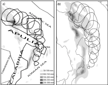
Different simulations have been performed with the two modelling systems, changing the extent of the domains, the parameterization schemes, the initial/boundary conditions. Among the different numerical setups, the simulations that better reproduce the observed cyclone trajectory (as shown in Fig. 1, Moscatello et al., 2008) are shown in the present paper and are employed to investigate the physical mecha-nisms responsible for the cyclone development.
The integration domains are shown in Fig. 1: for the coarse-resolution simulations (WRF external grid and BO-LAM) the grid spacing is 16 km, while the inner domains (WRF inner grid and MOLOCH) cover southern Italy and the
36 M. M. Miglietta et al.: The role of surface fluxes in the development of a tropical-like cyclone
Figure 1. The domains of the different simulations (black box for WRF, grey box for BOLAM and MOLOCH). The track of the cy-clone as forecast with the WRF model (external grid) is represented with the black curve (a triangle denotes the position of the cyclone centre every 3 h; the track starts south-west of Tunisia at 00:00 UTC, 25 September 2006).
surrounding seas with a horizontal resolution of 4 km. For WRF, 30 terrain following levels are used for both the grids, with enhanced resolution in the lower atmosphere. The run starts at 00:00 UTC, 24 September, and lasts for 72 h. The 0.5◦
×0.5◦ ECMWF analyses provide the initial and
bound-ary conditions. The BOLAM (40 vertical levels) run starts at 12:00 UTC, 25 September, for 48 h, and is driven by the GFS global model forecasts (0.5◦
×0.5◦ horizontal
resolu-tion). MOLOCH (50 vertical levels) is nested at 00:00 UTC, 26 September. The parameterisation schemes employed in the models are summarised in Table 1.
3 Numerical simulations
Surface observations and remote sensing data clearly show that the small vortex possess characteristics typical of a trop-ical cyclone (see, for example, Figs. 3 and 5 in Moscatello et al., 2008). As we will discuss hereafter, numerical sim-ulations with both modelling systems are able to properly capture the timing and intensity of the small-scale-cyclone development, at least during its passage inland where surface data are available for comparison.
3.1 WRF model results
First, we analyse the surface fluxes over the sea as forecast with the WRF model. The track of the cyclone predicted with WRF (external grid) is shown in Fig. 1. After its gen-eration on the lee side of the Atlas Mountains, the vortex moves east-north-eastward toward Sicily. During the transit of the cyclone over the Strait of Sicily, the model predicts cold and dry air advection to the rear of a cold front mov-ing eastward along the central Mediterranean Sea. The de-velopment of convective cells and the associated downdrafts along the frontal line determines local temperature minima
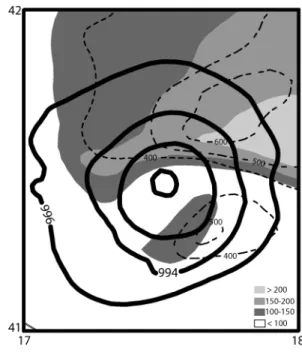
Figure 2. 996 hPa isobars (black contours), plotted every 1 h from 04:00 UTC to 14:00 UTC, 26 Sep 2006; total rainfall from 00:00 UTC to 14:00 UTC, 26 Sep (grey tones) as forecast with the WRF model-inner grid (a, left side) and MOLOCH (b, right side). The area shown in Fig. 4 is represented with the box in panel a.
and, thus, the temporary maximum of the sensible heat fluxes (HFX) increases to 120 W m−2. The saturated updrafts
pro-duce a warming that deepens the pressure minimum and then accelerates the wind speed. The latent-heat-fluxes maxima (LH) in the area of the cyclone remain almost constant at a value of ∼300–400 W m−2
: warm and dry air previously advected from the Sahara is responsible for relatively large values of LH occurring before the cyclonic circulation inter-acts with the frontal system. These quite large values of LH, which humidify the boundary layer, together with the low-level cooling due to the uplift induced by the incoming cold front, produce an environment favourable to the development of convection.
The time evolution of the 996 hPa isobars and the total rainfall in the following phases, as simulated by the high-resolution models, is shown in Fig. 2. During the passage of the vortex over the Ionian Sea, intense convective rain-fall is simulated over the sea close to Calabria. The precip-itation occurs ahead of the cyclone, and can be ascribed to the interaction of the south-easterly low-level flow, preced-ing a frontal line movpreced-ing from the Tyrrhenian to the Ionian Sea, with the steep orography of Calabria. As a consequence, strong uplift developing over the Ionian sea has the effect of generating convection in a environment that has become un-stable after the transit of the vortex to the south of Sicily. The precipitation intensity in the area suddenly increases from 60 mm/h to a maximum of 120 mm/h (with a peak of more than 250 mm in 3 h) at 03:00 UTC, 26 September. The devel-opment of deep convection produces large latent heat release, warming and a rapid drop of the pressure minimum (11 hPa in 3 h, 7 hPa in only 1 h). The time evolution of the pressure
minimum, and of the maxima of LH, HFX and wind speed maxima in the area of the vortex, simulated with WRF during the transit of the minimum over the Ionian and the Adriatic Sea, are shown in Fig. 3. In the interval 00:00–04:00 UTC, 26 September, when the strong intensification of the vortex occurs, the surface fluxes maxima do not increase, suggesting that the role of the surface fluxes is secondary with respect to the latent heat release.
At 06:00 UTC, 26 September, when the cyclone ap-proaches the Apulia region, LH and HFX reach their max-imum values, of 800 W m−2
and of 350 W m−2
respectively, with a delay of a couple of hours with respect to the deep-ening of the minimum and the consequent intensification of the wind speed. Thus, the total surface fluxes are larger than 1150 W m−2, a value consistent with the intensity expected
in tropical storms. In the following hours, the transit of the low inland slightly reduces the intensity of the fluxes, al-though the simulated pressure drops at its minimum value of 989 hPa and the simulated wind speed reaches its maxi-mum of 32 m s−1. The pressure drop when the vortex reaches
land is typical of hurricanes (Lagouvardos et al., 1999). At 09:00 UTC, the vortex reaches the Adriatic sea and the in-tensity of the fluxes grows again (Fig. 3). The intense fluxes in this phase (from 06:00 UTC to 10:00 UTC the total inten-sity ranges from 750 to 1150 W m−2
), which feed the envi-ronment with heat and humidity, cooperate with the latent heat release associated with convection to self-sustain the cy-clone. The pressure minimum deepens again, increasing the wind speed (10:00 UTC, 26 September).
During the passage of the vortex over the Adriatic Sea, the value of the pressure minimum remains around 990 hPa (Fig. 3), while the horizontal extent of the cyclone increases (the diameter of the area enclosed in the 996 hPa isobar grows from 60 to 100 km in this phase, see Fig. 2). There-fore, the pressure gradient progressively decreases and so do the wind speed and the surface fluxes, although their total in-tensity still remains larger than 700 W m−2
until 13:00 UTC, 26 September. The distribution of LH and HFX around the pressure minimum in this phase is shown in Fig. 4. Two maxima of LH are apparent, the main one is located to the north-east of the minimum pressure, where the largest wind speed is simulated. A similar distribution occurs for
Figure 3.Maximum values of HFX (in W m−2, rhomboidal dots), of LH (in W m−2, square dots), of wind speed (in m s−1, triangle dots); minimum pressure (in hPa, crosses); the values are extracted every 1 h from the WRF model – inner grid output. The maxima of the fluxes and of the wind speed are evaluated in a square box of 60×60 km centred in the pressure minimum. The fields are shown vs. time (h), from 00:00 UTC to 18:00 UTC, 26 Sep. The labels of the y-axis on the left side of the figure are relative to the fluxes; the mean sea level pressure is indicated on the right side outside the grey box, the wind speed is indicated on the right side but inside the grey box.
HFX. The location of the strongest fluxes nearly to the right side with respect to the direction of displacement of the cy-clone is consistent with previous observations and simula-tions of Mediterranean tropical-like cyclones (Pytharoulis et al., 1999). Finally, the low moves inland in the northern part of Apulia where it weakens.
3.2 MOLOCH results
The cyclone track, as forecast with MOLOCH (Fig. 2, right panel), appears quite similar to that predicted with WRF, although small differences occur. In particular, MOLOCH predicts a larger horizontal extent of the area enclosed by the 996 hPa isobar, slower movement and a track of the vor-tex that remains closer to the coast. Also, the precipitation
38 M. M. Miglietta et al.: The role of surface fluxes in the development of a tropical-like cyclone
Figure 4. Mean sea level pressure (c.i.=2 hPa), latent heat fluxes (dashed contours, c.i.=100 W m−2), sensible heat fluxes (grey areas) at 10:00 UTC, 26 Sep, forecast with WRF model-inner grid in the area shown in the box in Fig. 2a.
amount is larger, especially in the central part of Apulia, and the rainfall affects a larger area compared with WRF. The temporal evolution of the maximum values of the sur-face fluxes, wind speed and pressure minimum forecast with MOLOCH are shown in Fig. 5. Comparing these results with the WRF model output fields in Fig. 3, the pressure low pre-dicted by the two models decreases in the first few hours in a similar way (10 hPa in 3 h), but MOLOCH keeps deepening the pressure during the following hours, forecasting the low-est value of 974 hPa at 12:00 UTC, when the vortex is located over the Adriatic Sea. This value is much lower than the min-imum of 989 hPa forecast with WRF. As a consequence, the maximum wind speed and the most intense surface fluxes predicted with MOLOCH are larger and simulated with a few hour delay compared with WRF. The fact that the deep-ening of the pressure minimum occurs offshore, during the transit of the vortex over the Adriatic Sea, prevents a di-rect comparison with the observations in this phase, except for satellite and radar images (see Moscatello et al., 2008) which clearly display intense convection organised around a cloud-free centre. Thus, we cannot infer any conclusion about the ability of the models to correctly reproduce the full lifetime of the cyclone. However, when the cyclone crosses Apulia during the morning and the evening of 26 September respectively, the prediction of the two models are close to each other and to the observations: in fact, the minimum pre-dicted by the models during the transit of the vortex inland is respectively 989 hPa (WRF) and 983 hPa (MOLOCH) in
Figure 5.As Fig. 3, but for the MOLOCH forecast.
the morning (compared to the observed value of 986 hPa), 990 hPa (WRF) and 984 hPa (MOLOCH) in the evening (the observed minimum in this phase is 988 hPa). In general, the MOLOCH simulation confirms the interpretation of the role of the surface fluxes and latent heat release previously dis-cussed for the WRF model.
4 Conclusions
The scientific objective of the paper is the analysis of the role of surface fluxes in the development of a tropical-like cy-clone over the Mediterranean Sea, using two different mod-eling systems (BOLAM-MOLOCH and WRF). MOLOCH and WRF are able to reproduce correctly the observed track of the cyclone, although a weaker deepening and a faster dis-placement of the low over the Adriatic Sea is predicted by WRF. The reasons for such discrepancies will be the subject of further study.
Although an analysis of the role of the fluxes has been performed in other studies of “Mediterranean cyclones”, the mechanisms of development of these cyclones are not yet fully understood and require further investigation. Thus, a detailed description of the time evolution of the surface fluxes is addressed here. The simulation results with the two models agree in showing that surface fluxes are larger in the mature phase but are more important with respect to latent heat release during the development of the cyclone close to Sicily, where convection around the vortex is not fully de-veloped yet. The fact that contributions from the latent heat flux outweigh that of the sensible heat flux by two or three times and that the surface fluxes are important mainly during the deepening of the low is consistent with previous studies (Lagouvardos et al., 1999; Reale et Atlas, 2001). The hori-zontal structure of the fluxes, with maximum values around the low rather than above the centre, is also consistent with previous observations of tropical-like cyclones (Lagouvardos
in the proximity of the cyclone, while the reports were most likely not taken in its most active part.
Further experiments have been performed with both the modelling systems using the factor separation technique (Stein and Alpert, 1993). The simulations with both the models agree in showing the orographic origin on the lee side of the Atlas Mountains (Moscatello et al., 2007) and the different role of the surface fluxes (sensible and latent heat) during the phases of evolution of the cyclone (Davolio et al., 2007b; Moscatello et al., 2007). In particular, it is shown that the surface fluxes are more relevant during the initial phase of development of the disturbance, when a shallow depression is evolving south of Sicily (the vortex is weaker if the surface fluxes are suppressed in this phase), while the latent heat release associated with convection is more important in amplifying the vortex as the cyclone deepens and moves over the Ionian Sea (switching off convection during the transit of the minimum over the Ionian Sea has the effect of preventing the deepening of the vortex). Later, over the Adriatic Sea, where the typical characteristics of a tropical-like cyclone are identified, surface fluxes and latent heat release are together responsible for the maintenance of the cyclone, supporting the hypothesis of a physical mecha-nism similar to that responsible of the intensification of the hurricanes (WISHE theory; Rotunno and Emanuel, 1987). These sensitivity experiments will be further addressed in a forthcoming paper.
Edited by: A. M. Sempreviva
Reviewed by: K. Lagouvardos and another anonymous referee
Model, Nat. Hazards Earth Syst. Sci., 7, 41–56, 2007, http://www.nat-hazards-earth-syst-sci.net/7/41/2007/.
Homar, V., Romero, R., Stensrud, D. J., Ramis, C., and Alonso, S.: Numerical diagnosis of a small, quasi-tropical cyclone over the western Mediterranean: Dynamical vs. boundary factors, Quart. J. Roy. Meteor. Soc., 129, 1469–1490, doi:10.1256/qj.01.91, 2003.
Lagouvardos, K., Kotroni, V., Nickovic, S., Jovic, D., and Kallos, G.: Observations and model simulations of a winter sub-synoptic vortex over the Central Mediterranean, Meteorol. Appl., 6, 371– 383, 1999.
Moscatello, A., Miglietta, M. M., and Rotunno, R.: Analysis of a Mediterranean “hurricane” over south-eastern Italy, Proceed-ings of the 2007 International Conference on Alpine Meteorol-ogy, Chamb´ery, France, 2, 545–548, 2007.
Moscatello, A., Miglietta, M. M., and Rotunno, R.: Observational analysis of a Mediterranean ‘hurricane’ over south-eastern Italy, Weather, in press, 2008.
Pytharoulis, I., Craig, G. C., and Ballard, S. P.: The hurricane-like Mediterranean cyclone of January 1995, Meteorol. Appl., 7, 261–279, 2000.
Reale, O. and Atlas, R.: Tropical Cyclone–Like Vortices in the Extratropics: Observational Evidence and Synoptic Analysis, Weather Forecast., 16, 7–34, 2001.
Rotunno, R. and Emanuel, K.: An air-sea interaction theory for tropical cyclones. Part II: Evolutionary study using a nonhydro-static axysimmetric numerical model, J. Atmos. Sci., 44, 542– 561, 1987.
Skamarock, W. C., Klemp, J. B., Dudhia, J., Gill, D. O., Barker, D. M., Wang W., and Powers, J. G.: A description of the Advanced Research WRF Version 2. NCAR Tech. Note 468STR, 88 pp., 2005.
Stein, U. and Alpert, P.: Factor separation in numerical simulations, J. Atmos. Sci., 50, 2107–2115, 1993.