HAL Id: hal-02310425
https://hal-univ-rennes1.archives-ouvertes.fr/hal-02310425
Submitted on 10 Oct 2019
HAL is a multi-disciplinary open access
archive for the deposit and dissemination of
sci-entific research documents, whether they are
pub-lished or not. The documents may come from
teaching and research institutions in France or
abroad, or from public or private research centers.
L’archive ouverte pluridisciplinaire HAL, est
destinée au dépôt et à la diffusion de documents
scientifiques de niveau recherche, publiés ou non,
émanant des établissements d’enseignement et de
recherche français ou étrangers, des laboratoires
publics ou privés.
Distributed under a Creative Commons Attribution| 4.0 International License
Making virtual archeology great again (without scientific
compromise)
Marie-Anne Paradis, Théophane Nicolas, Ronan Gaugne, Jean-Baptiste
Barreau, Réginald Auger, Valérie Gouranton
To cite this version:
Marie-Anne Paradis, Théophane Nicolas, Ronan Gaugne, Jean-Baptiste Barreau, Réginald Auger,
et al.. Making virtual archeology great again (without scientific compromise). CIPA 2019 - 27th
CIPA International Symposium - Documenting the Past for a Better Future, Sep 2019, Ávila, Spain.
pp.879-886, �10.5194/isprs-archives-XLII-2-W15-879-2019�. �hal-02310425�
MAKING VIRTUAL ARCHEOLOGY GREAT AGAIN
(WITHOUT SCIENTIFIC COMPROMISE)
M.-A. Paradis 1, T. Nicolas 2, R. Gaugne 3, J.-B.. Barreau 4, R. Auger 1, V. Gouranton 5
1 Département of historical science, Univ Laval, Québec, Canada - [email protected]; [email protected] 2 Inrap, UMR Trajectoires, Rennes, France - [email protected]
3 Univ Rennes, Inria, CNRS, IRISA, France - [email protected]
4 Univ Rennes, CNRS, CReAAH, France - Jean-Baptiste BARREAU - [email protected] 5 Univ Rennes, INSA Rennes, Inria, CNRS, IRISA, France - [email protected]
Commission II, WG II/8
KEY WORDS: Virtual reality, digital archaeology, cyberarchaeology, 3D environment, digital phenomenology, methodology
ABSTRACT:
In the past two decades or so, digital tools have been slowly integrated as part of the archaeological process of information acquisition, analysis, and dissemination. We are now entering a new era, adding the missing piece to the puzzle in order to complete this digital revolution and take archaeology one step further into virtual reality (VR). The main focus of this article is the methodology of digital archaeology that fully integrates virtual reality, from beta testing to interdisciplinary teamwork. We briefly discuss data acquisition and processing necessary to construct the 3D model, the analysis that can be conducted during and after the making or creation of the 3D environment and the dissemination of knowledge. We explain the relevance of this methodology through the case study on the intendant’s palace, an 18th century archaeological site in Quebec City, Canada. With this experience, we believe that VR can prompt new questions that would never have occurred otherwise and can provide technical advantages in terms of gathering data in the same virtual space. We conclude that multidisciplinary input in archaeological research is once again proven essential in this new, inclusive and vast digital structure of possibilities.
1. INTRODUCTION
Any new technology gives us new ways to approach archaeological excavations, research, interpretation and communication. But what is it about virtual reality that makes it a game changer? Virtual reality gives us the opportunity to test multiple hypotheses, combine different types of data, project a fourth dimension (and one that is at the core of the archaeologist interest), and create a landscape closer to the past topography and natural environment. Additionally, through VR, we witness a democratization of the data gathered.
Analysis is not the only aspect to benefit from 3D and 4D information about our 3D and 4D world; the accessibility of the final product allows a vast range of feedback from colleagues – in archaeology, history, art, anthropology, etc. – the local communities and the general public. This feedback and the never-ending additions to the virtual environment are also important aspects, giving flexibility unattainable by means of the usual paper report or book – or even a 3D representation. Virtual reality as part of the four components of digital archaeology research, combined with the multiple recommendations on scientific rigour on virtual heritage, generate a complete puzzle that encompasses every challenge of archaeology. From the challenges of the excavation process to popularization of the data for the public, this process gives a complete framework in which to better accomplish archaeological objectives.
Here we propose a four-part methodology that embraces new acquisition and processing technology; teamwork; 3D visualization, simulations and interactions, as many have developed over the years (Knabb, Schulze, Kuester, DeFanti and Levy, 2014); some core principles of public archaeology; and a phenomenology angle. Our goal is to take advantage of the technological changes that are rapidly taking over the field of archaeological, by not only learning how each tool works, but also changing our mindset to facilitate an entirely different
interpretation paradigm. The intention behind the development of this methodology is not to give a detailed list of software and tutorials to follow (both of which would soon become obsolete). Instead, it is to provide a general workflow with which to experiment in academic or private collaborative research in archaeology and computer science. We believe that the “digital archaeologist” will soon invade the private sector, proving an opportunity to push the boundaries of both the investigation and its public dissemination. We argue that we, as archaeologists and computer scientists, ought to open the discussion about a new structure of archaeological research that will ultimately require governmental support and vision in order to be fully implemented. Needless to say, our institutions are all in need of a little update on the management of digital data that has already been produced and that will be produced in the future, and we will need to be able to transfer older 2D data into the digital arena. This paper on VR as a vital component of the digital archaeology methodology is intended to contribute to this vision. First, we give an overview of the structure we propose: 1) Data acquisition and processing: Enhance the current standard in information acquisition on-site through new technologies. 2) Analysis: Conduct analysis with the sole purpose of contributing to scientific research and the advancement of knowledge in its pure form. 3) Virtual reality: Enhance 3D visualization with interaction and immersion. 4) Dissemination: Use the 3D environment to communicate to different types of publics for dissemination, feedback, and “marketing”, in order to help make archaeology appealing. Then, we present the case study that helped us construct and experiment with the methodology. The results expose the technical advantages of the VR platform for archaeology (efficiency, variety of data in the same environment, scale visualization, night and day lighting visibility, handling without damage, etc.) as well as the new archaeological interpretations and questioning that were made possible. Finally, we provide more detail about the virtual reality domain and its various available applications for archaeology, being the key component of our proposition.
The International Archives of the Photogrammetry, Remote Sensing and Spatial Information Sciences, Volume XLII-2/W15, 2019 27th CIPA International Symposium “Documenting the past for a better future”, 1–5 September 2019, Ávila, Spain
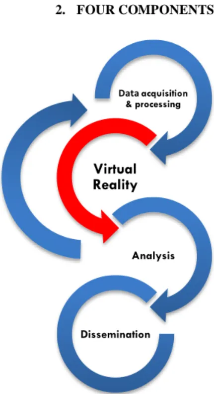
2. FOUR COMPONENTS
Figure 1. Four components of digital archaeology methodology
Each of those components contains a series of techniques necessary to execute the conceptual approach termed the methodology of digital archaeology. The basis of this proposition is the composition of a work team that includes one or more archaeologists, one graphic designer, a virtual reality specialist programmer and a computer engineer supervisor. Other specialists could take part in the acquisition phase (such as a land surveyor and a historians), virtual reality programming (such as an expert on smells equipment and programming in VR), and dissemination (such as a museum conservator), depending on the task at hand.
2.1 Data Acquisition and Processing
This first step into the process can be divided into two main concepts: the digital acquisition of existing elements and the 3D modelling of hypotheses. In these categories, there is also a subdivision: metadata kept explaining the content of the environment later on and the simplified data intended to be shared with the development team. Keeping a focus on the goal of the study helps better prioritise the time and efforts that are given for each element. The archaeologist establishes shared online file storage where the 3D file will be available for the team. The archaeologist can then start the acquisition of existing elements, which are easily understandable for everyone, in 3D format: In situ features, vestiges found during archaeological digs, and artifacts found during archaeological digs (e.g., Méreuze, Jarhaus, Dawson, Friesen, 2017). The role of the archaeologist is to gather those 3D format documents and keep detailed track of their provenience for the metadata, which is placed in parallel file storage. The acquisition necessary for the 3D modelling starts with some conversion into 3D format, such as modifying a Light Detection and Ranging (LIDAR) cloud to elevations found in archaeological reports or finds photos, or of drawings or 3D models of artifacts that only have detailed written information (morphology, size, colour, and material). We could characterise the data acquisition and processing as an ongoing process, which involves not only verifying the quality of the
acquired data, but also validating the scientific accuracy and reliability of these data.
2.2 Analysis
The analytical process can be divided into two parts: technical analysis and phenomenological analysis. These two parts have yet to be fully experimented on in archaeology. As Maurizio Forte exposed in the paradigm shift he proposed between virtual archaeology and cyberarchaeology almost ten years ago:
“Cyber Archaeology can represent today a research path of simulation and communication, whose ecological-cybernetic relations organism-environment and informative-communicative feedback constitute the core. […] Virtual Archaeology was mainly visual, static, graphic and oriented to photorealism, Cyber-archaeology is not necessarily visual, but dynamic, interactive, complex, autopoietic and not necessarily oriented to photorealism” (Forte, 2010, p.10).
In other words, the goal is not the digitization of reality but, rather, obtaining a tool to further our understanding and conception of past reality through efficient realism. In this respect, a lot has been done already in virtual archaeology and the visualization of heritage. The proposition for digital archaeology is to explore not only the affordances proposed by cyberarchaeology, but also the visual comparisons between timelines and between different people of different horizons, and the new type of phenomenology available with this platform (see, for example, Falconer, 2018). With those technical and archaeological results, it is necessary to go back to the original data to confront the analysis with its source and achieve a critical view of the process (figure 1).
2.3 Virtual Reality
The scientific domain of virtual reality continues to expand its limits. There are tools already available for archaeologists, but the potential for advancement is extensive. Virtual reality uses an interaction interface, such as a headset covering your entire vision, or an immersion room where you have to wear sensors and adapted glasses to see in 3D – to immerse the user inside a virtual world. Inside this virtual world, which can be an archaeological site or a presentation of archaeological objects, the user(s) can interact with this environment in real time (Arnaldi, Guitton, and Moreau, 2018). The archaeologist is able to incorporate most of the data acquired in the first step and add some simple programming to interact with those objects. However, teamwork is essential at this point to develop the analytical environment needed by the archaeologist. We will discuss this procedure in the following pages.
2.4 Dissemination
The digital document can be an archaeological environment or a cooperative scientific tool, but it can also be adapted for various publics. This possibility brings up the interesting concept of public archaeology. In this disciplinary practice and theoretical position, many consider that it is the duty of archaeologists to reach out to the public and make their work available and comprehensive (Richardson and Almansa-Sánchez, 2015). We suggest that the methodology of digital archaeology requires a democratic approach, whereby any public can be a passive receiver of knowledge but also an active participant able to generate new feedback from an angle that eluded the researcher (Richardson and Almansa-Sánchez, 2015; Holtorf, 2007).
Data acquisition & processing
Virtual
Reality
Analysis DisseminationThe International Archives of the Photogrammetry, Remote Sensing and Spatial Information Sciences, Volume XLII-2/W15, 2019 27th CIPA International Symposium “Documenting the past for a better future”, 1–5 September 2019, Ávila, Spain
This contribution has been peer-reviewed.
3. CASE STUDY
There are two main reasons for choosing to elaborate Quebec City intendant’s palace as a case study. This first one is the interesting problematic of the archaeological site itself. Surrounded by modern buildings and isolated from the main tourist area of the city, this important historical heritage is not well known by the local community or tourists (Nadeau, 2008). Ironically, this lack of popularity is not due to the lack of attention from researchers. The intendant’s palace has been the focus of a Université Laval archaeology program for 26 years. Research conducted by government or academics has included detailed, precise and systematic excavation campaigns as well as more than ten specialised studies, from environmental studies to material culture analysis (Bain, Auger and Monette, 2017). More recently, an interpretation centre has opened within the walls of the original vaults of the palace to explain the discoveries and the function of the site. Even after these efforts, the general public has difficulties in grasping the importance of this building and its inhabitants. Thus, there is a need to better understand the past landscape and to share that knowledge.
The second reason is to validate the methodology by applying the principles on a well-studied site. Despite the fact that numerous different researchers have worked on the site, it is possible to superimpose the maps and the archaeological data with almost perfect accuracy which makes it a reliable source, and despite the fact that the research done all those years was mainly in 2D or at least in a 2D mindset. By experimenting with this well-known site, we have the possibility not only to access a lot of reliable documentation, from a variety of sources, but also to see if we can offer a new perspective.
3.1 Historical Context
The intendant’s palace was located at the heart of what was then the French colony of New France, corresponding to the modern-day city of Quebec, in eastern Canada. The intendant’s role was to oversee the colony’s civil administration especially settlement, economic development and administration of justice which made the intendant’s position the second-most influential position in the colony after that of the governor (Ouellet, 2018; Auger, 2010). This archaeological site lies in the core of Quebec City’s French heritage, with its four centuries of occupation. The site has undergone several phases of occupation during those centuries. The first one started in 1650, with the construction of a shipyard. In 1668, at the beginning of the French colony, intendant Jean Talon built a brewery; later he added a potash plant. The brewery was later transformed into the first palace for the intendant, which, unfortunately, burnt down in 1713. A second palace was erected a few years later in front of the ruins that were to become the magasin du roy. The second palace was the intendant’s residence and the administrative centre for the colony. It caught fire in 1725, resulting in a second reconstruction. During the battle between France and Britain in 1760, the French lost to the British, who spared the palace. In 1775, it became a refuge for the American troops that besieged the city, prompting the British troops to bomb the palace to get rid of the enemy. The vaults of the second palace have survived to this day, even after the abandonment of the site until 1853, when Boswell bought and transformed the remains into a brewery once again, starting the industrial period of the site, which lasted until well into the 1960s (Bain, Auger and Monette, 2017; Moussette, 1994).
3.2 Research Goal
We chose to concentrate our experiment on a very specific time frame, when the work on the second palace was officially over, in 1719 (Mercier-Méthé, 2012). This period was chosen, because of the amount of information available and its historic significance. For the phenomenology analysis, we emphasised the architecture, the spatial organization of the site and the topography. Linked to that interpretation framework, we also conducted a viewshed analysis of three different points of view.
3.3 Data Acquisition and Processing
The sources gathered included two historical maps, from 1716 and 1717, and two architectural plans for the palace, from 1715 and 1718. We have more than ten archaeological reports from excavations that covered that period and hundreds of related photographs. Iconography references from later periods were also used to get a different perspective or to validate the reconstruction hypothesis. For the natural environment, we used two specialised analyses, one on insects, used as a proxy to reconstruct the trees and plants of the surroundings, and the other on plant macroremains directly. We started our reconstruction from the ground up, commencing with the soil information and geographical positioning. The Lidar file of the region provides a good basis, which we modified to the topography of the decade we are interested in. We then georeferenced the maps of the findings of the archaeological digs and the historical maps. The historical maps, drawings, and texts then formed the basis for the 3D representation, created in collaboration with the graphic designer. Since the palace and its architecture are one of the main focal points, this representation is the object that required the most time to model. A list of priorities, aligned with the final analysis projected, dictates the level of detail required for each element.
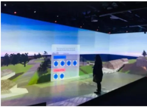
3.4 Virtual Reality Integration
Next, we added the elements directly into the virtual software Unity and chose the materials/textures for each of them. Aiming for an efficient yet realistic context, the computer researchers integrated a skymap to allow a change from day to night and back again. For navigation, the “ghost” mode was preferred, as it gives more possibilities of movement for the user to go in any direction without gravity. A main menu was created to explain the project and the controls and to allow the user to choose between an Edition mode (tr. edit mode) and a visualization mode of the initial hypothesis (Figure 2).
Figure 2. Test of the 3D model of the Intendance’s palace in an immersive room.
In the Edition mode, users can immerse themselves in the 1719 landscape but also have access to all the data that were used to build the environment. They click on each object, which opens a metadata canvas with information on the sources, the certainty level and the proposal for future advances on that particular
The International Archives of the Photogrammetry, Remote Sensing and Spatial Information Sciences, Volume XLII-2/W15, 2019 27th CIPA International Symposium “Documenting the past for a better future”, 1–5 September 2019, Ávila, Spain
object. Additionally, one button on the controller is programmed to open a secondary menu, which gives access to the photogrammetry of the modern building built on the foundations of the intendant’s palace, the 3D model of the modern city of Quebec and to selected archaeological excavations.
3.5 Results
In this immersive environment that we created, the archaeologist was able to integrate archaeological excavations, surveys, historical maps and architectural plans related to the period of study (Figure 3).
Figure 3. Archaeological excavation survey of 2009, which located the foundations of the staircase, inside the 3D virtual environment.
We also integrated the 3D model of the modern city of Quebec, giving another scale of comparison for the site and a way to visualise the urban landscape of the area directly inside the model. Following the same logic, the photogrammetry of the modern building that overlies the remains of the intendant’s palace is available through the secondary menu. Photogrammetry of the excavation, realised in 2009, is also available to investigate the remains of the monumental staircase of the entrance to the palace.
The results of this gathering of information were mainly positive, facilitating communication and comprehension, as well as saving time. This last element might seem debatable considering the amount of time necessary to gather the information. Nonetheless, we found efficiency with this methodology by gathering of a variety of types of data in the same virtual space. Time was gained not just for analysis, but also for future researchers, who will have at their fingertips information that is normally scattered across faculties, government bodies, websites, libraries, archives, archaeological sites, etc. Another foreseeable, but nonetheless interesting, result is the possibility of handling objects without alterations and visualization of those objects or landscape from every angle and at different scales. For example, we were able to see the inclusion of a few millimetres of lead inside an Egyptian amulet discovered by CT scan analysis, as well as a model of the entire City of Quebec (Figure 4).
Figure 4. Egyptian amulets discovered at the intendant’s palace archaeological site, showing a lead inclusion revealed by CT scan
analysis (left). 3D model of the modern city of Quebec (right).
Moving deeper into the archaeological input, the interpretation is able to evolve with access to the new perspective of this platform. For example, we found a distinct change in the size of the monumental staircase from the original plan of the architect compared with the archaeological remains that was not mentioned in the archaeological report. We can now speculate that the intention was to convey even more prestige than previously thought.
The phenomenological analysis also resulted in new interpretations for the surrounding buildings, mostly because of their impressive 3D volume we were able to perceive in the immersive room. It seems that the 2D plans were not doing justice to some infrastructure that now seems to be more significant to the functioning of the palace. Spatial organization of the area was also a main focus of interest in this analysis. Even if more questions than answers surfaced with this inquiry, engaging new aspects of the way people were occupying the area have emerged. The absence of a port at this important river crossroads leads to the hypothesis of smaller boats being used and hence more modest resource acquisition as dictated by that means of transportation, for example. To conclude the results of our phenomenological analysis, a final aspect was experimented: the perception at night. With the hypothesis that only two candles were lit outside of the palace during the night, the light level at night would have been very poor even on a full moon. This perception, impossible to recreate in our modern urban context, is available for our research inside the virtual environment. Darkness combined with the presence the nearby forest and wind gives us a sense of fear or stress. With those elements in mind, we can try to understand the need of the people at that time to build a protection around the property, at least against wild animals.
This concludes the review of the technical advantage to archaeology and a few of the archaeological interpretations that this virtual environment provided.
4. VIRTUAL REALITY
Virtual reality is a scientific domain in its own right, and it is not as recent as one might think. The concept can be traced back to the 1960s, with a paper by Ivan Sutherland describing VR as a “window through which a user perceives the virtual world as if looked, felt, sounded real and in which the user could act realistically” (Sutherland, 1965). The first 3D immersive simulators were separately created by Sutherland and by Morton Heilig, in 1962 (Cipresso, Giglioli, Raya and Riva, 2018). Heilig (1962) made a motorcycle simulation including sounds, smells, haptic and wind to immerse the user completely. For archaeology, a pioneer of the virtual archaeology concept was Paul Reilly, in 1990, with his simulation of an archaeological excavation. Another was a case study about the tomb of Queen Nefertari presented for an exhibition in Rome in 1994 (Karlsson, 2013). The tomb was reconstructed for viewers to be able to virtually visit the ancient site. More recently, in 2007, the Etruscan project developed a 3D model where the user could interact with avatars of inhabitants of the tomb, listen to narrative content and navigate by means of body movements (Pietroni, Pletinckx, Hupperetz and Rufa, 2013). In an even bigger vision and structure, the Conservatoire Numérique du Patrimoine Archéologique de l’Ouest (CNPAO) organization with the Institut de Recherche en Informatique et Systèmes Aléatoires (IRISA) in France produces research on digital heritage from production to analysis, using a multidisciplinary team (Barreau, 2017).
The International Archives of the Photogrammetry, Remote Sensing and Spatial Information Sciences, Volume XLII-2/W15, 2019 27th CIPA International Symposium “Documenting the past for a better future”, 1–5 September 2019, Ávila, Spain
This contribution has been peer-reviewed.
Here, following Arnaldi and colleagues, we propose to consider virtual reality as a “Scientific domain that uses computer science and interaction interfaces in order to simulate, in a virtual world, the behaviour of 3D entities that are interacting in real time with themselves and with one or more users. The user’s sensory-motor channels are engaged in a pseudo-natural immersion” (Arnaldi, Guitton, and Moreau, 2018). This encompasses a vast domain of research, which we not only have to synthesise for the purpose of this methodology presentation, but also have to adapt to the general needs and resources of archaeologists. We present a selection of possibilities of use that we consider interesting for research in archaeology. We also want to warn the reader that even though we try to keep the subject as timeless as possible, it still represents the situation of 2019, and things could easily change in this rapidly developing universe.
4.1 Teamwork
Virtual reality involves a multitude of tools, possible interactions, and functionalities that require the help of computer specialists if they are to be fully integrated. This collaboration is critical for the benefit of the time/efficiency ratio needed to carry out this digital archaeology project. As Schofield (2018, p. 11) wrote:
“Possibly, as VR gains in popularity, software solutions will emerge that enable museums and Cultural Heritage organizations to develop their own content more easily. However, the high production values necessary for historically accurate work suggests that skilled specialists will continue to be a necessary part of successfully realizing this type of production for the foreseeable future.”
The archaeologist’s role in this context is to define, as precisely as possible, the objective of their research and the effects desired from the tools that they want to implement. Communication is key at this point. For example, when asking for a house to be transparent, the archaeologist does not necessarily need transparency, but, rather, a visual indicator to represent that the presence of this house is a weak hypothesis. So instead of forcing the computer researchers to implement transparency, a conversation can be opened about different possibilities available within the optimal time frame. Sometimes the first proposition will still be exactly what is needed, but sometimes the proposition can also change completely depending on the priorities. Archaeologists have to keep in mind that there are endless possibilities to virtual reality, but some are needlessly time consuming for the desired results.
Furthermore, we recommend that the archaeologist produce a list of priorities and update it regularly. This list becomes a very useful tool for the other members of the team to keep track of the general workflow and the next steps, notably after being hyper-focussed on one variable at a time. Additionally, there is further efficiency to be found in a parallel workflow, where one person can work on coding while another can work inside the scene (e.g., by using Unity software). With this method, the project can generate results faster, not only by doubling the raw productivity, but also by doubling the problem-solving performance.
4.2 Scientific Rigour
An important aspect intrinsic to the development of 3D environment is the scientific rigour recommended by the international community working on digital heritage. The two main documents giving the primary guidelines for 3D visualization of heritage are the London Charter (Denard, 2009) and the Seville Principles (International Forum of Virtual
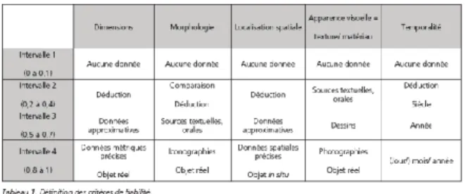
Archaeology, 2011). There are also the more than 30 documents produced since 1931 by ICOMOS (International Council on Monuments and Sites) and UNESCO that analyse the subject, including the physical heritage (see overview by Statham, 2019). The main concern is a misinterpretation of the information that might be conveyed to the public due to the visual realism, which might be mistaken for the historical truth (Statham, 2019). The digital archaeology methodology that we propose addresses those concerns and follows the recommendations to ensure scientific accuracy and transparency. We discuss the main five essential components, together with the concrete solution implemented in the Quebec intendant’s palace case study, following the recommendations of Statham (2019):
1) Transparency: The final product needs to explicitly state the type of reconstruction and the level of certainty.
Solution: In the main menu, the clear choice of visualization of a 3D reconstruction or Edition mode is given. Inside the Edition mode, it is possible to add or hide the photogrammetry of the modern palace, the 3D schematic representation of the entire modern city around the palace, and the reconstruction of the palace based on historical evidence.
For each element, a canvas with metadata can be selected that includes a table rating the level of certainty (notation from 0 to 5, maximum of 1 point per criteria):
Table 1. Criterias used in our Intendance’s palace case study from Fabre-Brun (2015) article
The Edition mode also represents in wireframe, as a quick visual indicator, those aspects with the lowest level of certainty (0 to 2).
2) Authenticity: The representations must respect the historical context by adding as many details as possible.
Solution: The name of the subject and the year of the research are given in the main menu, as well as a description of the goals, duration, and scope of the project. Research on the historical accuracy of the vegetation led to the incorporation of specific kinds of trees and soil, as well as a document listing the plant species that were recovered, which could be added in further work on the project.
3) Alternative hypotheses: Multiple hypotheses must be tested and visualised.
Solution: A first hypothesis is presented in the 3D reconstruction choice on the main menu. Inside the Edition menu, different hypotheses have been tested and visualised. Each canvas includes the metadata of each object, a short description, sources used, and an indication whether the representation is finished or not. This basis opens the possibility for multiple hypothesis
The International Archives of the Photogrammetry, Remote Sensing and Spatial Information Sciences, Volume XLII-2/W15, 2019 27th CIPA International Symposium “Documenting the past for a better future”, 1–5 September 2019, Ávila, Spain
representations that are later available as their own scene in the main menu.
4) Multiple historical periods: Multiple historical periods must be depicted.
Solution: The modern period can be selected in the Edition mode. Other periods can easily join the first phase of the intendant’s palace project.
5) Community engagement: Education and promotion of public awareness must be incorporated in the project goal.
Solution: The archaeological museum specialised in the intendant’s palace is part of the project, and to have a better understanding of the historical landscape of the archaeological site has been the main goal since the beginning. A project is in motion to integrate the virtual environment into the exhibition.
4.3 Database and Metadata
As mentioned in the acquisition presentation, the project inherited a team database with all the information needed to complete the virtual reality platform. The archaeologist also keeps a parallel file storage for all the metadata that is to be integrated.
4.3.1 Distributed Version Control System
In a VR project, another teamwork tool is necessary: the distributed version control system (such as Git or Mercurial). This system allows every version made during the entire process to be retained inside a repository on a computer server. This tool is not only interesting for keeping track of the progress, but it also plays the role of a safety net by generating copies of everything on every collaborator’s computer and by allowing users to go back to a previous state if anything goes wrong. We suggest that archaeologists use a graphical user interface (GUI) to help them understand and adopt this technique. A lot of different possibilities are available, such as TortoiseGit, GitKraken, Tower; the GUI used in the intendant’s palace project was SourceTree.
4.3.2 File Hierarchy
From the start, the file structure within the software needs to be organised as efficiently as possible, and this organization has to be maintained throughout the process. The principal categories are by type of file: Meshes/Objects, Materials, Textures, Shaders, Scenes, Scripts, Prefabs, and Tools. We suggest having a similar structure inside the scene and to identify every element with a code that will be easy to identify or search. For example, every object inside the intendant’s palace project has a related canvas with all the metadata. We kept the name “canvas” and then added the name of the object, e.g., “canvas_shed”. If we want to modify them all, the search is then simplified, especially if they are “hidden” in different subcategories. Another possible structure would be to separate the same 3D elements together: canvas, ground, water, walls, roofs, etc., instead of separating them by their historical entities (i.e., palace and all its component in a subcategory instead of each of its walls, doors, windows, etc. in its own subcategory).
4.3.3 Beta Testing
Even with the first iteration of the 3D environment, the archaeologist can perform some simple testing using open-source
software (e.g., Unity) and a virtual reality headset or immersive room. Those tests are completed all along the infographic and programming process to evaluate the quality of the model, the rapidity of processing and the further adjustments that are required. This is the usual process for virtual reality experts. It also ensures that there is no major problem that might compromise further changes.
4.4 Immersion and Interaction
- To better understand the concept of immersion and interaction, we present concrete applications that can be implemented in the platform. We see an interesting link between the interaction concept and the technical analysis that would later be conducted, as well as the immersion concept that would be closer to the phenomenology analysis. Here are some compelling interaction functionalities that are useful in a technical inquiry, together with examples from the literature: - Measuring objects: Measurement tools can be
programmed or can rely on tools already available (Vrui VR toolkit) for acquiring object geometry (Forte and Kurillo, 2010);
- Drawing coloured annotation on objects and notes: Annotation can highlight interesting features and comments (Vrui VR Toolkit, as seen in Forte and Kurillo, 2010);
- Flashlight function: Restrict the light to the controller to highlight only were the user is pointing (The Cairn of Carn project, as seen in Barreau, Gaugne, Bernard, Le Cloirec and Gouranton 2014);
- Manipulation of virtual objects or real objects in the virtual world (Fanini, Pagano and Ferdani, 2018); - Interaction with avatars that are historical figures,
ethnographic figures or fictive in the environment (Flaminia project in Dell’Unto, Di Ioia, Galeazzi, Moro, Pietroni, Vassallo and Vico, 2007);
- User avatar: to interact with the 3D environment and other avatars (Çatalhöyük project, in Morgan, 2009). - Simulations: lighting hypothesis on intensity,
disposition, type of oil used, etc. (Bawaya, 2010). Multiple senses are triggered inside a virtual environment, which can enhance the understanding of the archaeological subject at hand. Visual perception alone is able not only to see one or multiple environments, but also to access the metadata and the sources, as well as different hypotheses and chronological shifts (see example in Gaugne, 2018). But sounds can also play an important part, especially in a phenomenology analysis, where you want as much embodiment of the user inside this reality as possible (Serafin, 2004; Nordahl and Turchet, 2010). In this mindset, the smells, as well as the sensation of wind, rain or different temperatures are all fascinating possibilities to immerse the user even more in this parallel reality (Nakamoto, Otaguro, Kinoshita, Nagahama Ohinishi and Ishida, 2008; Schofield, Beale G., Beale, N., Fell, Hadley, Hook, Murphy, Richards and Thresh, 2018). A lot of scientific studies have been conducted on the concept of presence in virtual reality, which refers to the perception the user has of being inside an immersive virtual environment. That essential study assure us that archaeology can
The International Archives of the Photogrammetry, Remote Sensing and Spatial Information Sciences, Volume XLII-2/W15, 2019 27th CIPA International Symposium “Documenting the past for a better future”, 1–5 September 2019, Ávila, Spain
This contribution has been peer-reviewed.
have both limitations and possibilities in regards to perception of different stimuli (Duval, Nguyen, Fleury, Chauffaut, Dumont and Gouranton, 2014).
The immersion variable of virtual reality also opens up various questions on knowledge of the past. Archaeological digital phenomenology analysis definitely benefits from those applications:
- Infinite simulations are possible of the mechanical function of artifacts, lighting, natural disasters, fires, bombing, seasons, the efficiency of architectural structures, etc.
- The “ghost” mode makes it possible to get a different perspective on the archaeological subject, to get through tight, high, inaccessible or dangerous places. - Those perspectives are also a gateway to a variation of
scale, from the microscopic to the aerial.
- Scenarios and/or different scenes are able to present hypotheses and points of view adapted to the user.
4.5 Analysis in VR framework
Only one thing is certain in this process: a lot of mistakes, misunderstanding and lack of information will occur no matter how well prepared the project is. This is not something to be worried about, but something to welcome with open arms, as Pressner (2012) writes: “[…] experimentation and trial-and-error are inherent parts of digital research and must be recognized to carry risk”. We agree with the concept of failing productively, as presented by Shawn Graham (2017), which intertwines perfectly with the digital archaeology methodology, where the focus needs to be on the documentation of the process rather than on a fixed final outcome. By knowing this crucial fact ahead of time, you are able to better prepare your team to be in an “adapt mode” or “flexibility mode” and to prepare numerous meetings and/or establish a close working environment. Any participant in this project also has to acknowledge that the archaeologist will probably have to search for sources during the entire process and that the enormous editorial responsibility is not something most are comfortable with nor used to. Nevertheless, this uncomfortable position has the advantage of imposing scientific rigour on documenting the thought process and decision making of the archaeologist, as well as opening the 3D environment up to further research, since not every question that arises will have an immediate answer.
In the end, the key element that makes virtual reality the missing piece of the archaeological puzzle is the addition, in total immersion, of multiple senses at the same time. We are maybe used to the visual impact of a 3D representation, but virtual reality grants access to a whole new level of 360o, 3D and 4D (chronological changes), in an attempt to recreate the past. To this high-tech visual support, we are able to add soundscapes, smells and temperature perception to enhance the user experience, and we can also include the manipulation of 3D print objects and the use of haptic devices to simulate real motions. Never in the history of archaeological research have we been so close to recreating the complete context of an archaeological site and so close to recreating the context of the past to the best of our knowledge.
5. CONCLUSION
In our view, the new tools for the acquisition of information in archaeology and the software processing available are not an end in themselves. Virtual reality gives us a new 3D and 4D perspective to better understand and question the past. The analysis that can be achieved with this process is similar to that possible with present techniques, but with an intriguing and promising digital twist. We also see the value of the fascinating intrinsic nature of the process, which makes it easier to inform the public and to reach out for feedback. The intendant’s palace case study is a cornerstone for this methodology, by giving a four-century, history-packed context that was well studied. With those reliable sources, we are able to bring a strong hypothesis to the project and to develop further hypotheses from this strong basis. Furthermore, virtual reality, as a not-so-young research field, provides great tools, applications, structure and opportunities to the field of archaeology. We consider that this technology (including hardware and software) and multidisciplinary teamwork are the two main elements that will change archaeological investigation as we know it. We are at the point where it is now possible to achieve great scientific advances using tools that primarily seems too close to leisure and games. Virtual reality provides a great opportunity to investigate the past with our senses and an embodiment of space, while creating a fun and aesthetic dissemination device. A detailed archaeological report left on a government office shelf is not the way to successfully transmit our passion and make our field appealing to the public. Since public interest and desire to fund is a major part of the archaeological research system, it is essential for the future of this scientific domain to captivate audiences and make them participate: Virtual reality is a tool that until recently was missing from our repertoire.
ACKNOWLEDGEMENTS
This work is part of the ANR-16- FRQC-0004 INTROSPECT project (http://introspect.info), we thank all the members who contributed.
REFERENCES
Auger, R., 2010. Le site du palais de l’intendant à Québec, industrie et pouvoir : l’Intendance sous Jean Talon en Nouvelle-France. In L’Intendance aux sources de l’administration locale. Les Amis de Jean Talon (Ed.), Éditions Dominique Guéniot, Langres & Les Amis de Jean Talon, Châlons-en-Champagne, pp. 123-139.
Arnaldi, B., Guitton, P., Moreau, G., 2018. Virtual reality and
augmented reality: Myths and realities. ISTE, France.
Bain, A., Auger, R., Monette, Y., 2017. Îlot des Palais. Synthèses des recherches sur les études en archéologie environnementale, l’évolution du bâti et les études archéométriques sur la culture matérielle. Cahiers d’archéologie du CELAT, 42. CELAT, Quebec.
Barreau, J.-B., 2017. Étude d’une structure dédiée à la production et l’exploration de données 3D appliquées à la recherche en archéologie. Archéologies numériques, OpenScience 17(1), 1-10.
Barreau, J.-B., Gaugne, R., Bernard, Y., Le Cloirec, B., Gouranton, V., 2014. Virtual Reality Tools for the West Digital Conservatory of Archaeological Heritage. VRIC 2014, ACM. Laval, France, pp. 1-4.
The International Archives of the Photogrammetry, Remote Sensing and Spatial Information Sciences, Volume XLII-2/W15, 2019 27th CIPA International Symposium “Documenting the past for a better future”, 1–5 September 2019, Ávila, Spain
Bawaya, M., 2010. Virtual Archaeologists Recreate Parts of Ancient Worlds. Science, New Series 327(5962), 140-141. Cipresso, P., Giglioli, I., Raya, M.A., Riva, G., 2018. The Past, Present, and Future of Virtual and Augmented Reality Research: A Network and Cluster Analysis of the Literature. Frontiers in
Psychology 9, 2086.
Dell'Unto, N., Di Ioia, M., Galeazzi, F., Moro, A., Pietroni, E., Vassallo, V., Vico, L., 2007. The Reconstruction of the
Archaeological Landscape Through Virtual Reality Applications: A Discussion about Methodology. ISPRS
International Workshop, Zurich, Switzerland.
Duval, T., Nguyen, T., Fleury, C., Chauffaut, A., Dumont, G., Gouranton, V., 2014. Improving Awareness for 3D Virtual Collaboration by Embedding the Features of Users’ Physical Environments and by Augmenting Interaction Tools with Cognitive Feedback Cues. Journal on Multimodal User
Interfaces 8(2), 187-197.
Falconer, L., Scott, C., 2018. Phenomenology and Phenomenography in Virtual Worlds: An Example from Archaeology. In Falconer, L. and Gil Ortega, M.C., (Eds.) Virtual
Worlds: Concepts, Applications and Future Directions. Nova
Science Publishers, New York, pp. 1-38.
Fanini, B., Pagano, A., Ferdani, D., 2018. A Novel Immersive VR Game Model for Recontextualization in Virtual Environments: The μVRModel. Multimodal Technologies and
Interaction 2(2), 20.
Favre-Brun, A., 2015. Architecture virtuelle et représentation de l’incertitude : analyse des solutions de visualisation de la représentation 3D, Vergnieux, Robert; Delevoie, Caroline (eds.).
Actes du colloque Virtual Retrospect 2013, Nov 2013. Ausonus,
Pessac, France, pp. 91-96.
Forte, M., 2010. Introduction to Cyber-Archaeology. In M. Forte (ed.), Cyber-Archaeology. BAR International Series 2177. Archaeopress, Oxford, pp. 9-13.
Forte, M., Kurillo, G., 2010. Cyberarchaeology: Experimenting with Teleimmersive Archaeology, In16th International Conference on Virtual Systems and Multimedia, IEEE Computer
Society, Seoul, pp. 155-162.
Gaugne, R., Samaroudi, M., Nicolas, T., Barreau, J.-B. Garnier, L. et al., 2018. Virtual Reality (VR) Interactions with Multiple
Interpretations of Archaeological Artefacts.16th
EUROGRAPHICS Workshop on Graphics and Cultural Heritage. Vienna, Austria, pp. 1-9.
Graham, S., 2017. Failing Productively. In The Open Digital
Archaeology Textbook. https://o-date.github.io/draft/book/ failing-productively.html
Heilig M., 1962. Sensorama simulator. U.S. Patent No 3, 870. United States Patent and Trade Office, Virginia.
Holtorf, C., 2007. Archaeology Is a Brand! Routledge, NY. Karlsson, C., 2013. Visualizing Archaeology with Virtual Reality Tools. Master’s thesis, Lund University.
Knabb, K., Schulze, J., Kuester, F., DeFanti, T., Levy, T., 2014. Scientific Visualization, 3D Immersive Virtual Reality
Environments, and Archaeology in Jordan and the Near East.
Near Eastern Archaeology, Special Issue: Cyber-Archaeology 77(3), 228-232.
Mercier-Méthé, R., Grignon, M., 2012. L’intendant de la Nouvelle-France et l’architecture : la convenance dans un contexte colonial. CELAT, Quebec.
Méreuze, R., Jarhaus, A., Dawson, P., Friesen, T.M., 2017. Documenting a site in the Arctic using 3D, between archaeological research and environmental changes: Kuukpak, Northwest Territories, Canada. ISTE OpenScience, Digital
Archaeology 1(1), 1-11.
Morgan, C.L., 2009. (Re)Building Çatalhöyük: Changing Virtual Reality in Archaeology. Archaeologies 5(3), 468-487.
Moussette, M., 1994. Le site du Palais de l’intendant à Québec :
genèse et structuration d’un lieu urbain. Nouveaux Cahiers du
CELAT. CELAT, Quebec.
Nadeau, R., 2008. Le second palais de l’Intendant à Quebec : mise en valeur virtuelle d’un lieu archéologique. Master’s thesis, Université Laval, Québec.
Nakamoto, T., Otaguro, S., Kinoshita, M., Nagahama M., Ohinishi, K., Ishida, T., 2008. Cooking Up an Interactive Olfactory Game Display. Computer Graphics and Applications 28(1), 75-78.
Nordahl, S.S.R., Turchet L., 2010. Sound Synthesis and Evaluation of Interactive Footsteps for Virtual Reality Applications. In Proceedings of IEEE Virtual Reality
Conference, Massachusetts, USA, pp. 147-153.
Pietroni, E., Pletinckx, D., Hupperetz, W., Rufa, C., 2013. Etruscanning 3D: An Innovative Project about Etruscans. Archaeology in the Digital Era II: E-Papers from the 40th Conference on Computer Applications and Quantitative Methods in Archaeology: Southampton, 26-30 March 2012. Amsterdam University Press, Amsterdam, pp. 66-76.
Reilly, P., 1990. Towards a Virtual Archaeology. Computer
Applications in Archaeology. British Archaeological Reports
International Series 565, Archaeopress, Oxford, pp.133-139. Richardson L.-J., Almansa-Sánchez, J., 2015. Do You Even Know What Public Archaeology Is? Trends, Theory, Practice, Ethics. World Archaeology 47(2), 194-211.
Schofield, G., Beale G., Beale, N., Fell, M., Hadley, D., Hook, J., Murphy D., Richards, J., Thresh, L., 2018. Viking VR: Designing a Virtual Reality Experience for a Museum. In ACM DIS
Conference on Designing Interactive Systems 2018, 09-13 Jun 2018. Association for Computing Machinery, Hong Kong, pp.
1-11.
Serafin, S., Serafin G., 2004. Sound Design to Enhance Presence in Photorealistic Virtual Reality. In Proceedings of ICAD
04-Tenth Meeting of the International Conference on Auditory Display, Sydney, Australia, July 6-9. [publisher, place, pp. -).
Statham, N., 2019. Scientific rigour of online platforms for 3D visualization of heritage. Virtual Archaeology Review 10(20), 1-16.
Sutherland I.E., 1965. The Ultimate Display. Multimedia: From
Wagner to Virtual Reality. Norton, New York
The International Archives of the Photogrammetry, Remote Sensing and Spatial Information Sciences, Volume XLII-2/W15, 2019 27th CIPA International Symposium “Documenting the past for a better future”, 1–5 September 2019, Ávila, Spain
This contribution has been peer-reviewed.