1/2
Resistivity imaging of an analogue of the transition zone between the sedimentary
cover and the basement of deep sedimentary basin for geothermal exploitation in
Alsace
J. Portéab, M. Darnetb, J-F Girarda, N. Coppob, J-M Baltassatb, F. Bretaudeaub, P. Wawrzyniakb, Samantha Neebab,
Skah Bissavetsyab and Pierre-Daniel Mattheya
a. IPGS (UMR 7516 CNRS / University of Strasbourg), 5, rue Descartes, 67084 Strasbourg, France b. BRGM (French Geological Survey), 3, av. Cl. Guillemin, BP 6009 45060, Orléans, France
j.porte@brgm.fr Keywords: 3D CSEM, Resistivity imaging, Analogue, Geothermal exploration
ABSTRACT
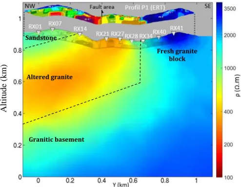
The transition zone between the basement and the sedimentary cover is becoming an increasingly attractive target for the development of geothermal energy in deep sedimentary basin as encountered in the Upper Rhine Graben. Several geothermal power plants already exploit this target but the transition zone is however still poorly known, with presence of large permeability heterogeneities. Studies in the framework of the CANTARE-Alsace project are currently on going in order to develop conceptual models on how it is formed and how heat can be exploited. In this study, we evaluate the ability of resistivity imaging by Controlled-Source Electromagnetic (CSEM) method in frequency domain, to identify favorable areas for the development of Enhanced Geothermal System (EGS). We performed a land-CSEM survey on a shallow analogue of the transition zone in a well-known catchment basin at Ringelbach (Vosges), to assess the relevance of such data. The catchment basin of Ringelbach is a well-known hydrogeological site, analogous in surface to our target in depth. According to previous geophysical studies (Two well logs, ERT…), the site is composed of resistive sandstone (>1600 Ω.m) superposed over two granitic facies with a NE-SW fault separating the site in two blocks. The first one is identified as a weathered granite being conductive (250-1600 Ω.m), whereas the second one appears as a block of fresh granite with a strong resistive signature (>1600 Ω.m). We know from former laboratory measurements (Belghoul, 2007) that conductivity of Ringelbach granites is related to its alteration degree and porosity. Furthermore, weathered granites show signs of former hydrothermal alteration succeeding the granite burial (Wyns, 2012). Fresh granitic basement is not reached by wells (150 meters depth) or former geophysical studies (Limited around 50 meters depth)
The 3D Land-CSEM survey consists in a 3D-grid of 48 reception sites uniformly distributed over the whole basin and using a single transmitter located at 1.5 km north from the grid. We performed 2.5D inversions of a data subset with the 2.5D inversion code MARE2DEM (Key, 2016) to image resistivity structures through a profile of interest (Figure 1) and compared the result to a former Electrical Resistivity Tomography (ERT) inversion. 3D inversion of the entire dataset are currently on-going using the BRGM proprietary software POLYEM3D for 3D CSEM and MT data inversion. Preliminary 3D results are consistent with the 2.5D resistivity image.
CSEM inversion results extended shallow ERT images in depth and allowed to obtain a resistivity image of the transition zone analogue. Integration of these results with existing geological and geophysical knowledge allowed identifying and mapping the different resistivity blocks: the resistive sandstone; the altered granite area more conductive, altered and potentially more permeable; the resistive fresh granites with the “Bunker” block (Right on Figure 1) as well as the fresh granitic basement, less porous thus less favorable for a geothermal reservoir. Results of this analogue study demonstrate the importance of obtaining resistivity data at the target depth before drilling to maximize the success rate of a deep EGS project. Upscaling work will be part of the last work package of the CANTARE-Alsace project.
Porté et al.
6th European Geothermal Workshop, Strasbourg, France, 10-11 Oct. 18 2/2
Figure 1: CSEM data 2.5D inversion result over the P1 profile from Baltassat et al. (2018). Former ERT inversion is displayed and its shadow is projected over our CSEM result with the fault crossing location (from geological map) represented by an arrow.
Source location is around -1.5 km in the y-direction with a 0.4 km shift on the x-axis. Dashed lines separate geological blocks interpreted from the integration of CSEM inversions and previous geophysical and geological knowledge.
Acknowledgement:
The research leading to these results has received funding from the ANR Programme under grant agreement ANR-15-CE06-0014 (Project CANTARE-Alsace).
Large-scale modeling and inversion was performed thanks to GENCI (Grand Equipement National de Calcul Intensif) and CINES (Centre Informatique National de l’Enseignement Supérieur) on the supercomputer OCCIGEN.
REFERENCES
Baltassat JM (2018) Réinterprétation des investigations géophysiques du bassin du Ringelbach avec les données de forages et les mesures en laboratoire. Tech. rep., BRGM/RP-66694-FR
Belghoul A (2007) Caractérisation pétrophysique et hydrodynamique du socle cristallin. PhD thesis, Université Montpellier II-Sciences et Techniques du Languedoc
Key K (2016) MARE2DEM: a 2-D inversion code for controlled-source electromagnetic and magnetotelluric data. Geophysical Journal International 207(1):571–588
Wyns R (2012) Etude géologique du cadre structural et des forages du bassin versant de recherche du Ringelbach (Soultzeren, haut-rhin). Tech. rep., BRGM/RP-56540-FR
Sandstone Altered granite Granitic basement Fresh granite block